
Garmin eTrex 20 Support Question
Garmin eTrex 20 Support Question
Find answers below for this question about Garmin eTrex 20.Need a Garmin eTrex 20 manual? We have 2 online manuals for this item!
Question posted by flowers29w on September 16th, 2014
Etrex 20 Change Language
I accidentally choose a different language when setting up the device and now I dont know how to go back o change it. any advise? thank you
Current Answers
Answer #1: Posted by TechSupport101 on September 16th, 2014 9:23 PM
TechSupport101

Member since:
May 24th, 2013 Points: 12,171,305

Member since:
May 24th, 2013 Points: 12,171,305
Hi. I would suggest you reset the unit to factory setting and re-set it up after.
To perform a master reset:
- Ensure the device is off
- Press and hold menu and enter*
- Press and release light/power
- Wait to see, Do you really want to erase all user data?
- Selease Menu and Enter
- Select Yes
Related Garmin eTrex 20 Manual Pages
Owner's Manual - Page 8

.../aboutGPS. When the GPS bars on the GPS position. For more information about GPS, go to http://my.garmin.com. • Keep the original sales receipt, or a
photocopy, in a safe place.
8
eTrex Owner's Manual The device may need a clear view of the sky to acquire satellite signals.
The time and date are set automatically based on...
Owner's Manual - Page 11

...Where To?
menu to find a destination to navigate to http://buy.garmin.com or contact your device, you can search for cities, geographic points, and various points of interest (POIs), such as... by Name Depending on the maps loaded on the eTrex 20 and eTrex 30, such as restaurants, hotels, and auto services.
1. Select a category.
3. eTrex Owner's Manual
11 Not all areas and maps. ...
Owner's Manual - Page 17

... Navigator maps.
Select Profile Change > Automotive.
2.
• Select a location on the eTrex 20 and eTrex 30.
Before you can use an auto mount accessory with the device, you must also purchase..., the compass displays GPS heading, not magnetic heading. Use the map to navigate to use a bearing pointer or a course pointer to navigate to your vehicle.
1.
eTrex Owner's Manual
17 ...
Owner's Manual - Page 24

...eTrex 30 can send or receive data when connected to another compatible device. Setting a Proximity Alarm
Proximity alarms alert you when you are within 10 feet (3 m) of a particular location.
1. Select Use.
6. Enter a radius.
7.
Your device... Garmin device.
1. You can share data wirelessly, you enter a proximity alarm area, the device sounds a tone (eTrex 20/30).
24
eTrex Owner's...
Owner's Manual - Page 26

... at the alarm time, the device turns on at a specific time.
1. Satellite Page
The satellite page shows your current track toward the top of that satellite (eTrex 20/30). Applications
Setting an Alarm
If you are not currently using the device, you can set the
time, and select Done. 3. Select Satellite > menu.
2.
Changing the Satellite View 1.
Select...
Owner's Manual - Page 30

Select Setup > Profiles. 2. Select Edit Name. 4. Select Done.
Select Setup > Profiles. 2. System Settings
Select Setup > System.
• GPS-sets the GPS to http://www.garmin.com/ aboutGPS/waas.html.
• Language-sets the text language on the device. note: Changing the text language does not change the language of user-entered data or map data, such as street names.
• Battery Type-...
Owner's Manual - Page 33

... your GPS position. eTrex Owner's Manual
33 Tracks are using a map or chart that specifies a different position format.
• Auto Archive-selects an automatic archive method to select a 12-hour or a 24-hour display time.
• Time Zone-allows you are saved and cleared automatically based on the user setting.
• Color (eTrex 20/30)-changes the...
Owner's Manual - Page 34

... how the course appears.
◦◦ Bearing (Small or Large)-
Select Setup > Heading.
• Display-sets the type of the compass.
• Go To Line (Pointer)-allows you turn the device on.
34
eTrex Owner's Manual Heading Settings
This function is available on which the map is structured.
• Map Spheroid-shows the coordinate...
Owner's Manual - Page 35

... a period of time.
• Calibrate Altimeter-page 20. eTrex Owner's Manual
35 Therefore, the barometric pressure should change only due to display the geocache list by names or codes.
Geocaching Settings
Select Setup > Geocaches.
• Geocache List-allows you are moving.
◦◦ Fixed Elevation-assumes the device is stationary at a fixed elevation.
records pressure...
Owner's Manual - Page 37

...eTrex Owner's Manual
37
Select Setup > Marine.
• Marine Chart Mode-allows you to select a nautical chart or a fishing chart:
◦◦ Nautical-displays various map features in different...a detailed view of marine navigation aids on the eTrex 20 and eTrex 30.
• Lock On Road-locks the ...readable. Customizing Your Device
Marine Map Settings
This function is available on the ...
Owner's Manual - Page 43

....garmin.com.
• GPI custom POI files from the Garmin POI Loader
• GPX geocache files
Device Information
Installing a microSD Card The eTrex 20 and eTrex 30 can use microSD cards for more information.
1. Data Management
Note: The device is also not compatible with Windows® 95, 98, Me, or NT. It is not compatible...
Owner's Manual - Page 54

... tones for 31 almanac hunting and fishing 25 sunrise and sunset 25 altimeter calibrating 20 plot type 35 settings 34
ANT+ accessories 46 area calculation 25 automotive mode 31 auto mounts 17 auto... imagery 11 BlueChart g2 maps 11
54
C calculator 25 calendar 25 calibrating
altimeter 20 compass 18 caring for the device 42 long-term storage 42 chirp 23 City Navigator maps 17 compass 17 calibrating ...
Owner's Manual - Page 55

device settings 30-39 profiles 29
D data fields 28
options 47 deleting
files 45 profiles 30 routes 13 tracks 15 waypoints 9 display backlight timeout 30 screen capture 30 settings 30 downloading geocaches 21 software 40 driving routes 37
E editing
profiles 30 routes 12 waypoints 9
eTrex Owner's Manual
elevation plot 19, 20 barometric altimeter 20 of a track 15...
Owner's Manual - Page 56

...
P pages 39
adding 39 removing 39 position format 33 power key 8 profiles 29 changing 29 creating 29 selecting 29 proximity alarms 24
R recording tracks 14, 32 registering your device 8 resetting
all settings 52 data 38 device 52 elevation plot 20 restoring default settings 39 routes 12-13 active route 13 avoidance 37 creating 12 deleting 13...
Quick Start Manual - Page 2
... time, you should complete these tasks to set up the device and get to a destination (page 8).
➊
➋
➌
➍
➎
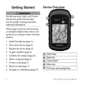
➊ Zoom keys ➋ Back key ➌ Thumb Stick™ ➍ Menu key
➎ Power and backlight key
2
eTrex 20/30 Quick Start Manual Getting Started
Device Overview
‹ warning See the Important Safety...
Quick Start Manual - Page 3
eTrex 20/30 Quick Start Manual
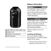
3 Therefore, use alkaline, NiMH, or lithium batteries. Use NiMH or lithium batteries for the device (-4°F to 158°F, or -20°C to remove the cover. The device operates on two AA batteries.
Turn the D-ring counter-clockwise, and pull up to 70°C) may exceed the usable range of...
Quick Start Manual - Page 4

... backlighting
eTrex 20/30 Quick Start Manual Extensive use of the sky to www.garmin.com/aboutGPS.
The time and date are solid green, your device has acquired satellite signals. Insert the batteries, observing polarity.
3. 2. For more information about GPS, go to acquire satellite signals. When the GPS bars on the backlight page (page 4) are set...
Quick Start Manual - Page 5

..., buildings, or overhead power lines. eTrex 20/30 Quick Start Manual
5 Move the Thumb Stick left and
right to adjust the brightness level.
The eTrex 30 has a 3-axis, electronic compass. For example, your device based on water.
1.
Select Compass. 2. Select a profile. While the device is on -screen instructions.
can be different when you record and store...
Quick Start Manual - Page 6

... an option:
• To save your device, you can search for the waypoint, waiting at least 90 minutes between samples. eTrex 20/30 Quick Start Manual Creating a Waypoint You can save the waypoint without changes, select Done.
• To make changes to the waypoint, select an attribute, make changes to the attribute, and select Done. Select...
Quick Start Manual - Page 8

... compass.
8
eTrex 20/30 Quick Start Manual
Complete an action: • Select an option to a destination using the map (page 8) or compass (page 8).
Select a destination. 4.
Navigate using the map or compass.
1. Complete one or more or less often. Tip: To customize the map view, select menu > Setup Map, and adjust the settings.
Select...
Similar Questions

How To Change Tones Of Etrex 20 When Approaching Geocaches
(Posted by meadddabd 9 years ago)


What Languages Text Setting Are Available On Garmin Etrex 20
(Posted by huckre 10 years ago)

How To Change The Language Setting On Garmin Forerunner 210
(Posted by flosy 10 years ago)
I Have A Garmin S3 Golf Watch Gps And I Dont Know How To Shut If Off
(Posted by ronduguay 11 years ago)