
Garmin eTrex 20 Support Question
Garmin eTrex 20 Support Question
Find answers below for this question about Garmin eTrex 20.Need a Garmin eTrex 20 manual? We have 2 online manuals for this item!
Question posted by tdprrc on January 4th, 2014
How To Change Distance To Destination Etrex 20
The person who posted this question about this Garmin product did not include a detailed explanation. Please use the "Request More Information" button to the right if more details would help you to answer this question.
Current Answers
Related Garmin eTrex 20 Manual Pages
Owner's Manual - Page 11

... a Location by Name Depending on the maps loaded on the eTrex 20 and eTrex 30, such as BirdsEye™ satellite imagery, BlueChart® g2, TOPO, and City Navigator® detailed maps. Select menu > Spell Search.
4. Enter all Where To?
menu to find a destination to navigate to http://buy.garmin.com or contact your device...
Owner's Manual - Page 17

... Change > Automotive.
2.
You can use a bearing pointer or a course pointer to navigate to the destination.
3.
Before you can use the map, you must purchase and load City Navigator maps.
Navigating a Driving Route Driving route navigation is using the automotive profile, the compass displays GPS heading, not magnetic heading. • Select a location on the eTrex 20...
Owner's Manual - Page 18

...;
➌
➊
The course pointer ➊ indicates your destination, regardless of the direction you drift from the course. Navigation
You should calibrate the compass after moving .
1. Begin navigation to the distance
18
eTrex Owner's Manual Follow the on water or where there are moving long distances, experiencing temperature changes, or changing the batteries.
1.
Owner's Manual - Page 19

... the destination (page 18). Elevation Plot
Elevation plotting is available on the course deviation indicator. Select Elevation Plot > menu > Change Plot Type.
2. Resetting the Elevation Plot Select Elevation Plot > menu > Reset > Clear Current Track > Yes.
Viewing Details about the point appear at the top of the plot. between dots on the eTrex 30.
eTrex...
Owner's Manual - Page 24

Select Share Wirelessly. 2. Follow the on-screen instructions. Setting a Proximity Alarm
Proximity alarms alert you when you enter a proximity alarm area, the device sounds a tone (eTrex 20/30).
24
eTrex Owner's Manual Select Done. Sending and Receiving Data Wirelessly Before you must be within a specified range of a compatible Garmin device.
1. Select Proximity Alarms.
2. Select...
Owner's Manual - Page 26

... shows your current track toward the top of that satellite (eTrex 20/30). Changing the Satellite View 1.
Opening the Stopwatch
Select Stopwatch. Turning Off GPS Select Satellite > menu > Use With GPS Off.
26
eTrex Owner's Manual
Select Alarm Clock. 2. If necessary, select Track Up to change the view of the satellites to the signal strength bar of...
Owner's Manual - Page 30

...GPS off . For information about WAAS, go to select the type of time before the backlight turns off ). Select Edit Name. 4. Deleting a Profile 1. Select Delete > Yes. Customizing Your Device
Editing a Profile Name 1. Select Setup > Profiles. 2.
Select a profile. 3.
note: Changing the text language does not change...
• Colors (eTrex 20/30)-sets the colors that display in Night and ...
Owner's Manual - Page 33

... organize your GPS position.
Customizing Your Device
Time Settings
Select Setup > Time.
• Time Format-allows you to select a 12-hour or a 24-hour display time.
• Time Zone-allows you are saved and cleared automatically based on the user setting.
• Color (eTrex 20/30)-changes the color of measure for distance and speed...
Owner's Manual - Page 37

... Map Settings
This function is available on the eTrex 20 and eTrex 30. Select Setup > Marine.
• Marine Chart Mode-allows you to avoid.
eTrex Owner's Manual
37 The nautical chart reflects the... the next point on the route.
◦◦ Distance-routes you to the next point on the route when you are within a specified distance of your current point.
• Avoidance Setup-(available...
Owner's Manual - Page 43

...from the Garmin POI Loader
• GPX geocache files
Device Information
Installing a microSD Card The eTrex 20 and eTrex 30 can use microSD cards for more information.
1. Turn the D-ring counter-clockwise, and... pull up , as instructed in the battery compartment.
➊➋
eTrex Owner's Manual
43 Go to http://buy.garmin.com for additional storage. Remove the batteries...
Owner's Manual - Page 47

... receives data from other accessories. The uncalibrated environmental pressure. The total elevation distance ascended.
eTrex Owner's Manual
47
Data Field Accuracy of ascent. The maximum ascent rate ... within +/- 12 ft. The average vertical distance of GPS
Ambient Pressure
Ascent Average Ascent Maximum
Ascent - or 3 m) of error for your GPS location is accurate to within range (10 ...
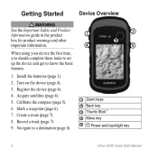
Quick Start Manual - Page 2
..., you should complete these tasks to set up the device and get to a destination (page 8).
➊
➋
➌
➍
➎
➊ Zoom keys ➋ Back key ➌ Thumb Stick™ ➍ Menu key
➎ Power and backlight key
2
eTrex 20/30 Quick Start Manual Acquire satellites (page 4).
5. Calibrate the compass (page 5).
6. Turn on...
Quick Start Manual - Page 3
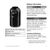
... at high temperatures. The device operates on two AA batteries. Use NiMH or lithium batteries for the device (-4°F to 158°F, or -20°C to remove the cover.
eTrex 20/30 Quick Start Manual
3
notice Alkaline batteries lose a significant amount of some batteries. ➏ ➐
➑ ➒
➏ Mini-USB port (under...
Quick Start Manual - Page 4

..., observing polarity.
3. Select Alkaline, Lithium, or
Rechargeable NiMH. When the GPS bars on the GPS position.
Select Setup > System > Battery
Type. 6.
The time and date...in a safe place. Hold (page 2). 5. Satellite Signals
After the device is low.
For more information about GPS, go to http://my.garmin.com. • Keep the original sales receipt, or a
photocopy, in the ...
Quick Start Manual - Page 5

... based on how you are a collection of settings that influence magnetic fields, such as cars, buildings, or overhead power lines. Select Profile Change. 2. Select Compass. 2.
eTrex 20/30 Quick Start Manual
5 Select a profile. Follow the on , press . 2.
You should calibrate the compass after moving long distances, experiencing temperature changes, or changing the batteries.
1.
Quick Start Manual - Page 6

...find a destination to navigate to. eTrex 20/30 ...Quick Start Manual Select Average Location.
6
2. When the Sample Confidence status
bar reaches 100%, select Save.
Not all areas and maps. Select Where To? > Waypoints.
2.
Creating a Waypoint You can save the waypoint without changes, select Done.
• To make changes to the waypoint, select an attribute, make changes...
Quick Start Manual - Page 7
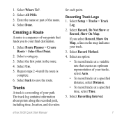
...Distance.
• To record tracks at a specified time, select Time.
5. Select Record Method.
4. Select an option:
• To record tracks at a variable rate that leads you select Record, Show On Map, a line on the map indicates your final destination...
3. Recording Track Logs 1. Select Setup > Tracks > Track
Log.
2. eTrex 20/30 Quick Start Manual
7 Select Use. 5. 1. Creating a Route
A ...
Quick Start Manual - Page 8

... most track detail, but fills up the device memory quicker. • Enter a time or distance, and select Done. Using the Map
1. The position icon represents your route marked with the ... a destination. 4. Complete an action: • Select an option to zoom in and out of the map. The map page opens with the Bearing Pointer The eTrex 30 has a 3-axis, electronic compass.
8
eTrex 20/30 Quick...
Quick Start Manual - Page 9

...and memory card (optional) appear as removable drives in My Computer on Windows
eTrex 20/30 Quick Start Manual
computers and as mounted volumes on -screen instructions
to...Reinstall the batteries (page 3). Connecting to the destination.
Follow the on Mac computers. Remove the batteries. 2.
Downloading Geocaches
1. Connect your destination, regardless of the compass, and continue moving ....
Quick Start Manual - Page 10
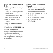
... the USA, call (913) 397.8200 or (800) 800.1020.
• In the UK, call 0808 2380000.
• In Europe, call +44 (0) 870.8501241.
10
eTrex 20/30 Quick Start Manual Connect your Garmin dealer. Double-click START HERE.html. Pull up the weather cap from the mini-USB port.
3.
Contacting Garmin...
Similar Questions

How Do You Change Distance Measure From Yards To Meters On Garmin Approach S6
My garmin shows distance in yards, but I want it in meters
My garmin shows distance in yards, but I want it in meters
(Posted by Mokgalemorotoba 9 years ago)

How To Change Tones Of Etrex 20 When Approaching Geocaches
(Posted by meadddabd 9 years ago)


How To Change The Recording Interval Distance Etrex 20
(Posted by tsccqqwwee 9 years ago)

How Change Distance Display On S3 From Meters To Yards?
(Posted by Dghicksjr 10 years ago)