
Garmin eTrex 20 Support Question
Garmin eTrex 20 Support Question
Find answers below for this question about Garmin eTrex 20.Need a Garmin eTrex 20 manual? We have 2 online manuals for this item!
Question posted by viJohnny on June 17th, 2014
How To Change Distance To Miles On Garmin Etrex
The person who posted this question about this Garmin product did not include a detailed explanation. Please use the "Request More Information" button to the right if more details would help you to answer this question.
Current Answers


Related Garmin eTrex 20 Manual Pages
Owner's Manual - Page 2

... and/or other countries. or its subsidiaries
All rights reserved. or its subsidiaries. Garmin®, the Garmin logo, eTrex®, BlueChart®, and City Navigator® are those of Garmin Ltd. Under the copyright laws, this product. Garmin reserves the right to make changes in part, without the written consent of SD-3C, LLC. Windows®...
Owner's Manual - Page 4

... Position Format Settings 33 Heading Settings 34 Altimeter Settings 34 Geocaching Settings 35 Routing Settings 36 Marine Map Settings 37 Fitness 38 Resetting Data 38 Changing the Page Sequence.....39
Device Information 40 Adjusting the Screen 40 Updating the Software 40 Viewing Device Information..........40 Specifications 41 About the Batteries 41...
Owner's Manual - Page 8

Registering Your Device
• Go to http://www.garmin.com/aboutGPS.
Satellite Signals
After the device is turned on the GPS position. For more information about GPS, go to http://my.garmin.com. • Keep the original sales receipt, or a
photocopy, in a safe place.
8
eTrex Owner's Manual
The time and date are solid green, your device...
Owner's Manual - Page 9

...waypoint.
1. Select an option:
• To save your current location as a waypoint.
1.
eTrex Owner's Manual
9 Waypoints, Routes, and Tracks
Finding a Waypoint 1. Select a waypoint. Select...Deleting a Waypoint 1. Editing a Waypoint Before you can save the waypoint without changes, select Done.
• To make changes to the waypoint, select an item to edit. 4. Creating a Waypoint ...
Owner's Manual - Page 17

... route navigation is using the automotive profile, the compass displays GPS heading, not magnetic heading. Select Profile Change > Automotive.
2. Navigation
Compass
The eTrex 30 has a 3-axis, electronic compass. You can use .... eTrex Owner's Manual
17 Calibrating the Compass
Notice Calibrate the electronic compass outdoors. • Select a location on the eTrex 20 and eTrex 30.
Owner's Manual - Page 18

...you drift from the intended course to the destination. Begin navigation to the distance
18
eTrex Owner's Manual About the Course Pointer The course pointer is based on ...Start.
2. Turn until points toward the top of the compass, and continue moving long distances, experiencing temperature changes, or changing the batteries.
1.
Select Compass.
3. As you are no major obstacles in that ...
Owner's Manual - Page 19

... Plot Type You can navigate with the course pointer, you can change the pointer setting to display pressure and elevation over
time or distance.
1. eTrex Owner's Manual
19 between dots on the eTrex 30. Navigating with the Course Pointer Before you must change the elevation plot to Course (CDI) (page 34).
1.
Select an option. Details...
Owner's Manual - Page 26

...the alarm time, the device turns on at a specific time.
1. Turning Off GPS Select Satellite > menu > Use With GPS Off.
26
eTrex Owner's Manual Select Alarm Clock. 2. Select an option. Changing the Satellite View 1.
If necessary, select Multicolor to assign a specific color to the... Page
The satellite page shows your current track toward the top of that satellite (eTrex 20/30).
Owner's Manual - Page 30

...), a dark background
30
eTrex Owner's Manual Customizing Your Device
Editing a Profile Name 1. For information about WAAS, go to Normal, WAAS/EGNOS (Wide Area Augmentation System/European Geostationary Navigation Overlay Service), or Demo Mode (GPS off . Deleting a Profile 1.
System Settings
Select Setup > System.
• GPS-sets the GPS to http://www.garmin.com/ aboutGPS/waas.html...
Owner's Manual - Page 33

...distance and speed, elevation, and pressure.
1.
You can customize units of Measure
You can select Automatic to set the time zone automatically based on the map. Position Format Settings
Note: Do not change the position format or the map datum coordinate system unless you to select the time zone for the setting. eTrex... setting.
• Color (eTrex 20/30)-changes the color of measure for ...
Owner's Manual - Page 35

... over a period of time.
◦◦ Elevation/Distance-records elevation changes over a distance.
◦◦ Barometric Pressure-records barometric pressure over a period of time.
◦◦ Ambient Pressure-records ambient pressure changes over a period of time.
• Calibrate Altimeter-page 20.
eTrex Owner's Manual
35 • Barometer Mode
◦◦ Variable Elevation...
Owner's Manual - Page 36
...garmin.com.
page 21.
• chirp™ Searching-page 23.
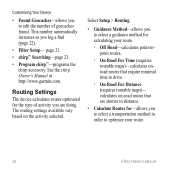
• Program chirp™-programs the chirp accessory. Select Setup > Routing.
• Guidance Method-allows you to select a guidance method for calculating your route.
36
eTrex...you to select a transportation method in distance.
• Calculate Routes for the type of geocaches found. calculates on the activity selected.
Owner's Manual - Page 47

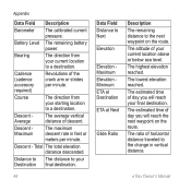
... is accurate to within range (10 ft. The average vertical distance of GPS
Ambient Pressure
Ascent Average Ascent Maximum
Ascent - or 3 m) of error for your Garmin device receives data from other accessories. The uncalibrated environmental pressure. eTrex Owner's Manual
47 The maximum ascent rate in feet or meters per minute. Data Field Options
Not...
Owner's Manual - Page 48
... Ratio
Description
The remaining distance to the change in feet or meters per minute. Descent Maximum
The maximum descent rate in vertical distance.
Cadence (cadence accessory required)
Revolutions of horizontal distance traveled to the next waypoint on the route. Distance to The distance to your current location above or below sea level. eTrex Owner's Manual
Total The...
Owner's Manual - Page 49
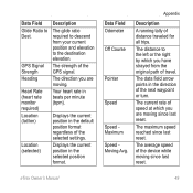
Your heart rate in the selected position format.
eTrex Owner's Manual
49
Displays the current position in beats per minute (bpm).
The strength of distance traveled for all trips.
Appendix
Description
A running tally of the GPS signal.
The maximum speed reached since last reset. The average speed of the device while moving since last...
Owner's Manual - Page 50

... you are closing on your GPS position. Trip Time Total
A running tally of sunset based on a
destination along a
route.
50
eTrex Owner's Manual
L
means turn... right. Sunrise
Sunset
Time of
difference (in which
Good
you must move to return to your
destination and your
current course. Trip Time Moving
A running tally of the distance...
Owner's Manual - Page 53
...
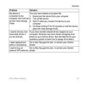
Go to http://buy .garmin.com, or contact your Garmin parts or accessories. I need replacement Go to http://buy .garmin.com, or contact your
mode.
eTrex Owner's Manual
53
If you... the device from your Garmin drives. Turn off the device. dealer. computer.
4.
Continue holding for your operating system to learn how to your Garmin
external GPS antenna.
dealer. I cannot...
Owner's Manual - Page 56

...adding 39 removing 39 position format 33 power key 8 profiles 29 changing 29 creating 29 selecting 29 proximity alarms 24
R recording tracks 14...8 resetting
all settings 52 data 38 device 52 elevation plot 20 restoring default settings 39 routes 12-13 active route 13 avoidance... 26, 47,
49, 52 system settings 30 turning off GPS 26, 27
saving tracks 15
sharing data 24 Sight N' Go...eTrex Owner's Manual
Quick Start Manual - Page 4

... Extensive use of the sky to acquire satellite signals.
2.
For more information about GPS, go to http://my.garmin.com. • Keep the original sales receipt, or a
photocopy, in the ...GPS bars on the GPS position. Replace the battery cover, and turn the D-ring clockwise.
4. Adjusting the Backlight
Note: The backlight brightness may need a clear view of screen backlighting
eTrex 20...
Quick Start Manual - Page 5

... on water.
1.
The eTrex 30 has a 3-axis, electronic compass. You should calibrate the compass after moving long distances, experiencing temperature changes, or changing the batteries.
1. Select ...influence magnetic fields, such as cars, buildings, or overhead power lines. eTrex 20/30 Quick Start Manual
5 Select Profile Change. 2. can be different when you are using it. Move the ...
Similar Questions

How Do You Change Distance Measure From Yards To Meters On Garmin Approach S6
My garmin shows distance in yards, but I want it in meters
My garmin shows distance in yards, but I want it in meters
(Posted by Mokgalemorotoba 9 years ago)

How To Change Tones Of Etrex 20 When Approaching Geocaches
(Posted by meadddabd 9 years ago)

How To Change The Recording Interval Distance Etrex 20
(Posted by tsccqqwwee 9 years ago)


How Do I Change Distance On Garmin 910xt To Miles?
(Posted by budavalgpo 10 years ago)