

Owner's Manual
Page 1
eTrex® owner's manual for use with models 10, 20, 30
eTrex® owner's manual for use with models 10, 20, 30

Owner's Manual
Page 3
...Navigation 16 Navigating to a Destination..........16 Map 16 Compass 17 Elevation Plot 19 Trip Computer 20 eTrex Owner's Manual Table of Contents Geocaches 21 Downloading Geocaches 21 Filtering the Geocache List..........21 ...24 Sharing Data 24 Setting a Proximity Alarm 24 Calculating the Size of Contents Getting Started 5 Device Overview 5 Using the eTrex Keys 6 Battery Information 7 Turning the Device On or Off.........8 Satellite Signals 8 Registering Your Device 8 Waypoints, Routes, and...Customizing Specific Pages........28 Profiles 29 System Settings 30 Display Settings...
...Navigation 16 Navigating to a Destination..........16 Map 16 Compass 17 Elevation Plot 19 Trip Computer 20 eTrex Owner's Manual Table of Contents Geocaches 21 Downloading Geocaches 21 Filtering the Geocache List..........21 ...24 Sharing Data 24 Setting a Proximity Alarm 24 Calculating the Size of Contents Getting Started 5 Device Overview 5 Using the eTrex Keys 6 Battery Information 7 Turning the Device On or Off.........8 Satellite Signals 8 Registering Your Device 8 Waypoints, Routes, and...Customizing Specific Pages........28 Profiles 29 System Settings 30 Display Settings...

Owner's Manual
Page 10
... for the waypoint, waiting at an object or in the direction, and then navigate to the object, and select Done > Save. 10 eTrex Owner's Manual Enter the distance to the object. 1. Select Start. 5. Point the device at least 90 minutes between samples. Select Lock ...Direction > Project Waypoint. 4. Using Sight 'N Go Sight 'N Go is available on the eTrex 30. Select Sight 'N Go. 2. Select Waypoint Averaging. 2. You can point the device at an object in the distance, lock in the direction of a location....
... for the waypoint, waiting at an object or in the direction, and then navigate to the object, and select Done > Save. 10 eTrex Owner's Manual Enter the distance to the object. 1. Select Start. 5. Point the device at least 90 minutes between samples. Select Lock ...Direction > Project Waypoint. 4. Using Sight 'N Go Sight 'N Go is available on the eTrex 30. Select Sight 'N Go. 2. Select Waypoint Averaging. 2. You can point the device at an object in the distance, lock in the direction of a location....

Owner's Manual
Page 11
...'s Manual 11 categories are available in all Where To? Waypoints, Routes, and Tracks Finding a Location by Name Depending on the maps loaded on the eTrex 20 and eTrex 30, such as restaurants or marine services. Select menu > Spell Search. 4. For more information, go to . Select Where To? > menu > Search Near. 2.... points, and various points of the name, and select Done. Select Where To?. 2. menu to find a destination to navigate to http://buy.garmin.com or contact your device, you can use the Where To? Enter all or part of interest (POIs), such as restaurants, hotels, and auto...
...'s Manual 11 categories are available in all Where To? Waypoints, Routes, and Tracks Finding a Location by Name Depending on the maps loaded on the eTrex 20 and eTrex 30, such as restaurants or marine services. Select menu > Spell Search. 4. For more information, go to . Select Where To? > menu > Search Near. 2.... points, and various points of the name, and select Done. Select Where To?. 2. menu to find a destination to navigate to http://buy.garmin.com or contact your device, you can use the Where To? Enter all or part of interest (POIs), such as restaurants, hotels, and auto...

Owner's Manual
Page 17
... as cars, buildings, or overhead power lines. Calibrating the Compass Notice Calibrate the electronic compass outdoors. eTrex Owner's Manual 17 • Select a location on the eTrex 20 and eTrex 30. If you plan to use the map, you must also purchase and install the mount in the text...the automotive profile, the compass displays GPS heading, not magnetic heading. Before you must purchase and load City Navigator maps. Navigation Compass The eTrex 30 has a 3-axis, electronic compass. You can use an auto mount accessory with the device, you can use a bearing pointer or a...
... as cars, buildings, or overhead power lines. Calibrating the Compass Notice Calibrate the electronic compass outdoors. eTrex Owner's Manual 17 • Select a location on the eTrex 20 and eTrex 30. If you plan to use the map, you must also purchase and install the mount in the text...the automotive profile, the compass displays GPS heading, not magnetic heading. Before you must purchase and load City Navigator maps. Navigation Compass The eTrex 30 has a 3-axis, electronic compass. You can use an auto mount accessory with the device, you can use a bearing pointer or a...

Owner's Manual
Page 19
... at the top of the plot. Begin navigation to Course (CDI) (page 34). 1. Details about a Point on the Plot Select an individual point on the eTrex 30. between dots on the course deviation indicator. Navigating with the course pointer, you must change the elevation plot to the destination (page 18). To customize...
... at the top of the plot. Begin navigation to Course (CDI) (page 34). 1. Details about a Point on the Plot Select an individual point on the eTrex 30. between dots on the course deviation indicator. Navigating with the course pointer, you must change the elevation plot to the destination (page 18). To customize...

Owner's Manual
Page 23
... can find a chirp in a geocache. A chirp is available on the eTrex 30. Geocaches Enable chirp Searching 1. Select Geocaches > menu > Show chirp™ Details. 2. eTrex Owner's Manual 23 • To enter a comment about programming a chirp, see the chirp Owner's Manual at http://www.garmin.com. Only the owner of the geocache that contains a chirp, details...
... can find a chirp in a geocache. A chirp is available on the eTrex 30. Geocaches Enable chirp Searching 1. Select Geocaches > menu > Show chirp™ Details. 2. eTrex Owner's Manual 23 • To enter a comment about programming a chirp, see the chirp Owner's Manual at http://www.garmin.com. Only the owner of the geocache that contains a chirp, details...

Owner's Manual
Page 24
... a location. 5. Select Send or Receive. 3. Select Proximity Alarms. 2. Select a category. 4. Select Use. 6. Applications Applications Sharing Data The eTrex 30 can share waypoints, geocaches, routes, and tracks. Select Create Alarm. 3. Enter a radius. 7. You can share information wirelessly. Sending and Receiving ... can send or receive data when connected to another compatible device. When you must be within a specified range of a compatible Garmin device. 1. Setting a Proximity Alarm Proximity alarms alert you when you are within 10 feet (3 m) of a particular location...
... a location. 5. Select Send or Receive. 3. Select Proximity Alarms. 2. Select a category. 4. Select Use. 6. Applications Applications Sharing Data The eTrex 30 can share waypoints, geocaches, routes, and tracks. Select Create Alarm. 3. Enter a radius. 7. You can share information wirelessly. Sending and Receiving ... can send or receive data when connected to another compatible device. When you must be within a specified range of a compatible Garmin device. 1. Setting a Proximity Alarm Proximity alarms alert you when you are within 10 feet (3 m) of a particular location...

Owner's Manual
Page 26
... track toward the top of the screen. 3. If necessary, select Track Up to change the view of that satellite (eTrex 20/30). Turning Off GPS Select Satellite > menu > Use With GPS Off. 26 eTrex Owner's Manual If the device is off at the selected time. Changing the Satellite View 1. The alarm sounds at the...
... track toward the top of the screen. 3. If necessary, select Track Up to change the view of that satellite (eTrex 20/30). Turning Off GPS Select Satellite > menu > Use With GPS Off. 26 eTrex Owner's Manual If the device is off at the selected time. Changing the Satellite View 1. The alarm sounds at the...

Owner's Manual
Page 30
...off . Display Settings Select Setup > Display. • Backlight Timeout-adjusts the length of AA battery you to http://www.garmin.com/ aboutGPS/waas.html. • Language-sets the text language on the device. For information about WAAS, go to select... > Profiles. 2. Note: To adjust the backlight brightness, see page 40. • Colors (eTrex 20/30)-sets the colors that display in Night and Day mode. ◦◦ Mode-sets a light background (Day), a dark background 30 eTrex Owner's Manual Select Done. Select Edit Name. 4. Select a profile. 3. Select Setup > Profiles...
...off . Display Settings Select Setup > Display. • Backlight Timeout-adjusts the length of AA battery you to http://www.garmin.com/ aboutGPS/waas.html. • Language-sets the text language on the device. For information about WAAS, go to select... > Profiles. 2. Note: To adjust the backlight brightness, see page 40. • Colors (eTrex 20/30)-sets the colors that display in Night and Day mode. ◦◦ Mode-sets a light background (Day), a dark background 30 eTrex Owner's Manual Select Done. Select Edit Name. 4. Select a profile. 3. Select Setup > Profiles...

Owner's Manual
Page 33
... a 24-hour display time. • Time Zone-allows you are saved and cleared automatically based on the user setting. • Color (eTrex 20/30)-changes the color of measure for the device. eTrex Owner's Manual 33 • Auto Archive-selects an automatic archive method to organize your GPS position. Select Setup > Position Format. •...
... a 24-hour display time. • Time Zone-allows you are saved and cleared automatically based on the user setting. • Color (eTrex 20/30)-changes the color of measure for the device. eTrex Owner's Manual 33 • Auto Archive-selects an automatic archive method to organize your GPS position. Select Setup > Position Format. •...

Owner's Manual
Page 34
...Datum-sets the coordinate system on which the map is structured. • Map Spheroid-shows the coordinate system the device is available on the eTrex 30. Heading Settings This function is using. Select Setup > Heading. • Display-sets the type of directional heading on the compass. •...at a higher rate of speed for a set period of the compass. • Go To Line (Pointer)-allows you turn the device on the eTrex 30. sets the direction to your destination. ◦◦ Course (CDI)-the course deviation indicator displays your relationship to a course line leading to a ...
...Datum-sets the coordinate system on which the map is structured. • Map Spheroid-shows the coordinate system the device is available on the eTrex 30. Heading Settings This function is using. Select Setup > Heading. • Display-sets the type of directional heading on the compass. •...at a higher rate of speed for a set period of the compass. • Go To Line (Pointer)-allows you turn the device on the eTrex 30. sets the direction to your destination. ◦◦ Course (CDI)-the course deviation indicator displays your relationship to a course line leading to a ...

Owner's Manual
Page 37
...point. • Avoidance Setup-(available only for optimal use while fishing. • Appearance-allows you to set the appearance of bottom contours and depth soundings. eTrex Owner's Manual 37 Select Setup > Marine. • Marine Chart Mode-allows you to select a nautical chart or a fishing chart: ◦◦ Nautical... reflects the drawing scheme of paper charts. ◦◦ Fishing-(requires marine maps) displays a detailed view of marine navigation aids on the eTrex 20 and eTrex 30. Customizing Your Device Marine Map Settings This function is available on the map.
...point. • Avoidance Setup-(available only for optimal use while fishing. • Appearance-allows you to set the appearance of bottom contours and depth soundings. eTrex Owner's Manual 37 Select Setup > Marine. • Marine Chart Mode-allows you to select a nautical chart or a fishing chart: ◦◦ Nautical... reflects the drawing scheme of paper charts. ◦◦ Fishing-(requires marine maps) displays a detailed view of marine navigation aids on the eTrex 20 and eTrex 30. Customizing Your Device Marine Map Settings This function is available on the map.

Owner's Manual
Page 42
Caring for the Device NOTICE Avoid chemical cleaners and solvents which can cause permanent damage. 42 eTrex Owner's Manual Cleaning the Device 1. Dampen a clean cloth with the damp cloth. 3. Water Immersion notice The device is not lost when batteries are removed. After ... device. Stored data is waterproof to IEC Standard 60529 IPX7. Device Information Long-Term Storage When you do not plan to use the device for 30 minutes.
Caring for the Device NOTICE Avoid chemical cleaners and solvents which can cause permanent damage. 42 eTrex Owner's Manual Cleaning the Device 1. Dampen a clean cloth with the damp cloth. 3. Water Immersion notice The device is not lost when batteries are removed. After ... device. Stored data is waterproof to IEC Standard 60529 IPX7. Device Information Long-Term Storage When you do not plan to use the device for 30 minutes.

Owner's Manual
Page 43
...compatible with Windows® 95, 98, Me, or NT. Go to http://www.garmin.com. • GPI custom POI files from the Garmin POI Loader • GPX geocache files Device Information Installing a microSD Card The eTrex 20 and eTrex 30 can use microSD cards for more information. 1. Remove the batteries or battery. 3.... earlier. File Types The device supports these file types. • Files from BaseCamp™ or HomePort™ Go to http://buy.garmin.com for additional storage. Turn the D-ring counter-clockwise, and pull up , as instructed in the battery compartment. ➊➋...
...compatible with Windows® 95, 98, Me, or NT. Go to http://www.garmin.com. • GPI custom POI files from the Garmin POI Loader • GPX geocache files Device Information Installing a microSD Card The eTrex 20 and eTrex 30 can use microSD cards for more information. 1. Remove the batteries or battery. 3.... earlier. File Types The device supports these file types. • Files from BaseCamp™ or HomePort™ Go to http://buy.garmin.com for additional storage. Turn the D-ring counter-clockwise, and pull up , as instructed in the battery compartment. ➊➋...

Owner's Manual
Page 46
...3 m) of the ANT+ accessory. 2. Select Setup > Fitness. 3. Select Heart Rate Monitor or Bike Cadence Sensor. 4. Select Search for the eTrex 30. Using Optional Fitness Accessories 1. Bring the device within range (10 ft. Customize your device. Optional Maps You can use ANT+™ wireless technology ...view the heart rate or cadence data (page 28). 46 eTrex Owner's Manual These accessories use the fitness accessory with your Garmin dealer. Optional Fitness Accessories Fitness accessories are available at http://buy.garmin.com or from your device, you can purchase additional maps,...
...3 m) of the ANT+ accessory. 2. Select Setup > Fitness. 3. Select Heart Rate Monitor or Bike Cadence Sensor. 4. Select Search for the eTrex 30. Using Optional Fitness Accessories 1. Bring the device within range (10 ft. Customize your device. Optional Maps You can use ANT+™ wireless technology ...view the heart rate or cadence data (page 28). 46 eTrex Owner's Manual These accessories use the fitness accessory with your Garmin dealer. Optional Fitness Accessories Fitness accessories are available at http://buy.garmin.com or from your device, you can purchase additional maps,...
Owner's Manual
Page 53
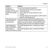
...the Help file for 30 seconds or until the device goes into mass storage 3. dealer. Disconnect the device from your operating system to learn how to assign drive letters. computer. 4. I want to buy an Go to http://buy .garmin.com, or contact your Garmin external GPS antenna. .... I need replacement Go to http://buy .garmin.com, or contact your Garmin parts or accessories. dealer. go into mass storage mode. I cannot see any new removable drives in my list of drives. Continue holding for your computer. eTrex Owner's Manual 53 If you connect the device...
...the Help file for 30 seconds or until the device goes into mass storage 3. dealer. Disconnect the device from your operating system to learn how to assign drive letters. computer. 4. I want to buy an Go to http://buy .garmin.com, or contact your Garmin external GPS antenna. .... I need replacement Go to http://buy .garmin.com, or contact your Garmin parts or accessories. dealer. go into mass storage mode. I cannot see any new removable drives in my list of drives. Continue holding for your computer. eTrex Owner's Manual 53 If you connect the device...

Owner's Manual
Page 54
... and fishing 25 sunrise and sunset 25 altimeter calibrating 20 plot type 35 settings 34 ANT+ accessories 46 area calculation 25 automotive mode 31 auto mounts 17 auto zoom 32 B backlight timeout 40 barometer 19 BaseCamp 43 batteries 30, 48 about 41 information 7, 41 installing 7 life...20 compass 18 caring for the device 42 long-term storage 42 chirp 23 City Navigator maps 17 compass 17 calibrating 18 navigating 18 restore 39 setup options 34 connecting to another device 24 USB cable 44 wireless accessories 46 course pointer 19 creating routes 12 waypoints 9 customizing data fields 28 eTrex...
... and fishing 25 sunrise and sunset 25 altimeter calibrating 20 plot type 35 settings 34 ANT+ accessories 46 area calculation 25 automotive mode 31 auto mounts 17 auto zoom 32 B backlight timeout 40 barometer 19 BaseCamp 43 batteries 30, 48 about 41 information 7, 41 installing 7 life...20 compass 18 caring for the device 42 long-term storage 42 chirp 23 City Navigator maps 17 compass 17 calibrating 18 navigating 18 restore 39 setup options 34 connecting to another device 24 USB cable 44 wireless accessories 46 course pointer 19 creating routes 12 waypoints 9 customizing data fields 28 eTrex...

Quick Start Manual
Page 5
...you are locations you are a collection of settings that influence magnetic fields, such as cars, buildings, or overhead power lines. The eTrex 30 has a 3-axis, electronic compass. Select Calibrate Compass > Start. 4. Select Compass. 2. Selecting a Profile Profiles are using the ... store in the device. Select Profile Change. 2. Calibrating the Compass Notice Calibrate the electronic compass outdoors. Select menu. 3. eTrex 20/30 Quick Start Manual 5 To improve heading accuracy, do not stand near objects that optimize your settings and views can significantly reduce...
...you are locations you are a collection of settings that influence magnetic fields, such as cars, buildings, or overhead power lines. The eTrex 30 has a 3-axis, electronic compass. Select Calibrate Compass > Start. 4. Select Compass. 2. Selecting a Profile Profiles are using the ... store in the device. Select Profile Change. 2. Calibrating the Compass Notice Calibrate the electronic compass outdoors. Select menu. 3. eTrex 20/30 Quick Start Manual 5 To improve heading accuracy, do not stand near objects that optimize your settings and views can significantly reduce...

Quick Start Manual
Page 8
... line. 5. 6. As you travel, the position icon moves. 2. Select Where To?. 2. The position icon represents your route marked with the Bearing Pointer The eTrex 30 has a 3-axis, electronic compass. 8 eTrex 20/30 Quick Start Manual As you move the map to different areas. • Select ▲ and ▼ to record tracks more or less often.
... line. 5. 6. As you travel, the position icon moves. 2. Select Where To?. 2. The position icon represents your route marked with the Bearing Pointer The eTrex 30 has a 3-axis, electronic compass. 8 eTrex 20/30 Quick Start Manual As you move the map to different areas. • Select ▲ and ▼ to record tracks more or less often.


