ME Software Manual
Page 24
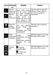
tap recalculation progress between 0% and 100%. Icon Informati on Details Action , Second route event (maneuver after the next maneuver) When GPS position and an active route are both available, this field shows the Tap this area simulation. Track Log recording 23 Stops the running simulation This...turn by turn guidance instructions. Route recalculatio n progress During recalculation, shows route this field the Nothing happens if you tap this area of the screen. - sounds strip muted/enabled Nothing happens if you this area of the screen. Indicator -
tap recalculation progress between 0% and 100%. Icon Informati on Details Action , Second route event (maneuver after the next maneuver) When GPS position and an active route are both available, this field shows the Tap this area simulation. Track Log recording 23 Stops the running simulation This...turn by turn guidance instructions. Route recalculatio n progress During recalculation, shows route this field the Nothing happens if you tap this area of the screen. - sounds strip muted/enabled Nothing happens if you this area of the screen. Indicator -
ME Software Manual
Page 25
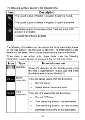
... following information can be seen in these fields show the following symbols appear in the Indicator strip: Icon Description The sound output of Nextar Navigation System is muted. Track log recording is always facing North (2D). Speed information There are speed values that can be shown: •...where you can be shown in the three data fields shown on the map screen. The sound output of Nextar Navigation System is available. Nextar Navigation System records a Track log when GPS position is enabled. Tap this area to reach the next via point • Estimated arrival...
... following information can be seen in these fields show the following symbols appear in the Indicator strip: Icon Description The sound output of Nextar Navigation System is muted. Track log recording is always facing North (2D). Speed information There are speed values that can be shown: •...where you can be shown in the three data fields shown on the map screen. The sound output of Nextar Navigation System is available. Nextar Navigation System records a Track log when GPS position is enabled. Tap this area to reach the next via point • Estimated arrival...

ME Software Manual
Page 72
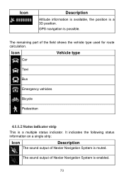
... quality • Battery status • Vehicle type used for route calculation • Sound status (muted or enabled) • Track log recording status 4.1.1.1 Battery, GPS position quality and Vehicle type indicator This area is a multiple status indicator, and also acts as a button. n/a Cursor (selected map n/a location) Lane information n/a Orange line ... levels, or to reset it to its original value. Most of them also function as a button that opens the Quick menu. 71 Symbol Name Current GPS position (on the map.
... quality • Battery status • Vehicle type used for route calculation • Sound status (muted or enabled) • Track log recording status 4.1.1.1 Battery, GPS position quality and Vehicle type indicator This area is a multiple status indicator, and also acts as a button. n/a Cursor (selected map n/a location) Lane information n/a Orange line ... levels, or to reset it to its original value. Most of them also function as a button that opens the Quick menu. 71 Symbol Name Current GPS position (on the map.
ME Software Manual
Page 74
GPS navigation is a 3D position. The sound output of Nextar Navigation System is muted. It indicates the following status information on a single strip: Icon Description The sound output of Nextar Navigation System is a multiple status indicator. Icon Description Altitude information is available, the position is possible. Icon Vehicle type Car Taxi Bus Emergency vehicles Bicycle Pedestrian 4.1.1.2 Status indicator strip This is enabled. 73 The remaining part of the field shows the vehicle type used for route calculation.
GPS navigation is a 3D position. The sound output of Nextar Navigation System is muted. It indicates the following status information on a single strip: Icon Description The sound output of Nextar Navigation System is a multiple status indicator. Icon Description Altitude information is available, the position is possible. Icon Vehicle type Car Taxi Bus Emergency vehicles Bicycle Pedestrian 4.1.1.2 Status indicator strip This is enabled. 73 The remaining part of the field shows the vehicle type used for route calculation.
ME Software Manual
Page 91
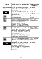
... needed (GPS receiver detection is selected in Route Planning options in Settings (page 107). If you only adjust the volume, you Opens the need to use this button and select the Vehicle type to Navigation menu. Name Main function (single tap) Function (tap and hold) Master Volume Adjusts the sound volume of Nextar Navigation...
... needed (GPS receiver detection is selected in Route Planning options in Settings (page 107). If you only adjust the volume, you Opens the need to use this button and select the Vehicle type to Navigation menu. Name Main function (single tap) Function (tap and hold) Master Volume Adjusts the sound volume of Nextar Navigation...


