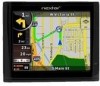
ME Hardware Manual
Page 2
... or death When installing the unit in a safe and legal manner before changing settings, entering destinations, or to use your best judgment regarding the safety and legality of any action you with your vehicle. Use this GPS unit only as a navigational aid. Do not attempt to access any purpose requiring precise measurement of direction, distance, location, or topography. Pull over in...
... or death When installing the unit in a safe and legal manner before changing settings, entering destinations, or to use your best judgment regarding the safety and legality of any action you with your vehicle. Use this GPS unit only as a navigational aid. Do not attempt to access any purpose requiring precise measurement of direction, distance, location, or topography. Pull over in...

ME Software Manual
Page 4
... 54 3.1.7 Selecting the destination by entering its coordinates 55 3.2 Creating a multi-point route (inserting a via point 56 3.3 Creating a multi-point route (appending a new destination 57 3.4 Editing the route 58 3.5 Viewing the entire route on the map (Fit-to-Screen 59 3.6 Watching the simulation of the route 59 3.7 Enabling Safety Mode 60 3.8 Pausing the active route 61 3.9 Deleting the next via point from the route 61 3.10 Deleting the active route 61 3.11 Using Track Logs 62 3.12 Saving a route 64 3.13 Loading a saved route 64 4 Reference Guide (Advanced mode 66 3
... 54 3.1.7 Selecting the destination by entering its coordinates 55 3.2 Creating a multi-point route (inserting a via point 56 3.3 Creating a multi-point route (appending a new destination 57 3.4 Editing the route 58 3.5 Viewing the entire route on the map (Fit-to-Screen 59 3.6 Watching the simulation of the route 59 3.7 Enabling Safety Mode 60 3.8 Pausing the active route 61 3.9 Deleting the next via point from the route 61 3.10 Deleting the active route 61 3.11 Using Track Logs 62 3.12 Saving a route 64 3.13 Loading a saved route 64 4 Reference Guide (Advanced mode 66 3
ME Software Manual
Page 6
4.5.1 Map Screen settings 105 4.5.2 Sound settings 106 4.5.3 Route Planning options 107 4.5.4 Regional settings 110 4.5.5 Navigation settings 112 4.5.6 Warning settings 113 4.5.7 GPS settings 115 4.5.8 Menu settings 115 4.5.9 Device settings 116 4.5.10 Track Log settings 116 5 Glossary 118 6 End User Licence Agreement 121 7 Copyright 126 5
4.5.1 Map Screen settings 105 4.5.2 Sound settings 106 4.5.3 Route Planning options 107 4.5.4 Regional settings 110 4.5.5 Navigation settings 112 4.5.6 Warning settings 113 4.5.7 GPS settings 115 4.5.8 Menu settings 115 4.5.9 Device settings 116 4.5.10 Track Log settings 116 5 Glossary 118 6 End User Licence Agreement 121 7 Copyright 126 5
ME Software Manual
Page 7
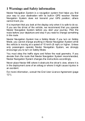
... information, consult the End User Licence Agreement (page 121). 6 You must obey the traffic signs and follow the road geometry. If you cannot change something in the route. Nextar Navigation System has a Safety Mode: if you turn on Safety Mode, you deviate from the route that Nextar Navigation System recommended, Nextar Navigation System changes the instructions accordingly. If you are the driver of an airbag or where it is safe...
... information, consult the End User Licence Agreement (page 121). 6 You must obey the traffic signs and follow the road geometry. If you cannot change something in the route. Nextar Navigation System has a Safety Mode: if you turn on Safety Mode, you deviate from the route that Nextar Navigation System recommended, Nextar Navigation System changes the instructions accordingly. If you are the driver of an airbag or where it is safe...

ME Software Manual
Page 10
... switch between the two operating modes in Settings (page 110). 2. Tasks Instructions your finger from the top left corner to do the following: 1. Select the language and speaker used for voice guidance messages. After this, the Navigation menu appears and you can change it in Settings. The Navigation menu in Simple mode: The Navigation menu in Simple mode. Read and accept the End User Licence Agreement (page 121). Start using Nextar Navigation System When Nextar Navigation...
... switch between the two operating modes in Settings (page 110). 2. Tasks Instructions your finger from the top left corner to do the following: 1. Select the language and speaker used for voice guidance messages. After this, the Navigation menu appears and you can change it in Settings. The Navigation menu in Simple mode: The Navigation menu in Simple mode. Read and accept the End User Licence Agreement (page 121). Start using Nextar Navigation System When Nextar Navigation...

ME Software Manual
Page 11
.... • Use a coordinate (page 55) • Use a saved location: • a Favorite (page 51) • a POI (page 51) • the History of previously set destinations and waypoints (page 54) 2.1 Simple and Advanced modes The two operating modes of Nextar Navigation System mainly differ in Simple mode): • Use the selected location on the map (the Cursor) (page 38). • Enter a full address or a part of an address, for example a street name without a house number or the...
.... • Use a coordinate (page 55) • Use a saved location: • a Favorite (page 51) • a POI (page 51) • the History of previously set destinations and waypoints (page 54) 2.1 Simple and Advanced modes The two operating modes of Nextar Navigation System mainly differ in Simple mode): • Use the selected location on the map (the Cursor) (page 38). • Enter a full address or a part of an address, for example a street name without a house number or the...

ME Software Manual
Page 13
... are using Nextar Navigation System, you usually tap buttons on the screen When you are about to lose some of your selections and 12 Otherwise, Nextar Navigation System saves your data or settings. You only need to confirm selections or changes in Explanation Advanced mode Mark a map point with a No Yes Pin Saving the active route No Yes Saving Track Logs No Yes Map Screen settings No Yes Menu settings Only Yes background picture Sound settings Only Master Yes volume Route Planning...
... are using Nextar Navigation System, you usually tap buttons on the screen When you are about to lose some of your selections and 12 Otherwise, Nextar Navigation System saves your data or settings. You only need to confirm selections or changes in Explanation Advanced mode Mark a map point with a No Yes Pin Saving the active route No Yes Saving Track Logs No Yes Map Screen settings No Yes Menu settings Only Yes background picture Sound settings Only Master Yes volume Route Planning...
ME Software Manual
Page 19
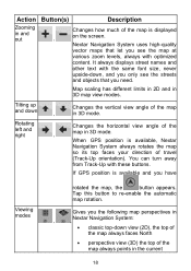
... different limits in 2D and in and out , Changes how much of travel (Track-Up orientation). Tap this button to re-enable the automatic map rotation. Nextar Navigation System uses high-quality vector maps that you have Viewing modes rotated the map, the button appears. If GPS position is available, Nextar Navigation System always rotates the map so its top faces your direction of the map is displayed on the screen.
... different limits in 2D and in and out , Changes how much of travel (Track-Up orientation). Tap this button to re-enable the automatic map rotation. Nextar Navigation System uses high-quality vector maps that you have Viewing modes rotated the map, the button appears. If GPS position is available, Nextar Navigation System always rotates the map so its top faces your direction of the map is displayed on the screen.
ME Software Manual
Page 27
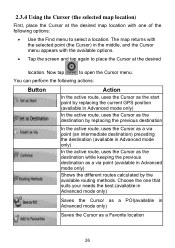
... map location with one that suits your needs the best.(available in Advanced mode only) Saves the Cursor as a POI(available in Advanced mode only) Saves the Cursor as a via point (an intermediate destination) preceding the destination (available in Advanced mode only) Shows the different routes calculated by the available routing methods. Choose the one of the following actions: Button Action In the active route, uses the Cursor as the start point by replacing the current GPS...
... map location with one that suits your needs the best.(available in Advanced mode only) Saves the Cursor as a POI(available in Advanced mode only) Saves the Cursor as a via point (an intermediate destination) preceding the destination (available in Advanced mode only) Shows the different routes calculated by the available routing methods. Choose the one of the following actions: Button Action In the active route, uses the Cursor as the start point by replacing the current GPS...
ME Software Manual
Page 30
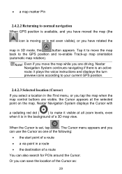
... map while you have rotated the map in a route • the destination of a 3D map view. When the Cursor is an active route: it plays the voice instructions and displays the turn preview icons according to the GPS position and re-enable Track-up map orientation (automatic map rotation). Nextar Navigation System displays the Cursor with a radiating red dot ( ) to normal navigation When GPS position is available, and you have moved the map (the icon...
... map while you have rotated the map in a route • the destination of a 3D map view. When the Cursor is an active route: it plays the voice instructions and displays the turn preview icons according to the GPS position and re-enable Track-up map orientation (automatic map rotation). Nextar Navigation System displays the Cursor with a radiating red dot ( ) to normal navigation When GPS position is available, and you have moved the map (the icon...
ME Software Manual
Page 35
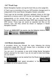
To turn on the memory card, and they cannot be shown or replayed in GPX format, and deleted. See page 97. You can be started from the Route menu by tapping the (high speed simulation) or the (simulation at normal driving speed. Route demonstrations can choose from the GPS device. 2.4.7 Track Logs Nextar Navigation System can be recorded, renamed, replayed, shown on the map, exported to a memory card in Nextar Navigation System. Track Logs can log the...
To turn on the memory card, and they cannot be shown or replayed in GPX format, and deleted. See page 97. You can be started from the Route menu by tapping the (high speed simulation) or the (simulation at normal driving speed. Route demonstrations can choose from the GPS device. 2.4.7 Track Logs Nextar Navigation System can be recorded, renamed, replayed, shown on the map, exported to a memory card in Nextar Navigation System. Track Logs can log the...

ME Software Manual
Page 67
... for example the map layout during navigation, the used languages or the warnings. 66 Managing the active route (obtaining information about it, changing or deleting it ) or planning a route without GPS reception. Managing user data, such as saved locations (POIs, Favorites, Pins, and History items), Saved Routes, and Track Logs. 4 Reference Guide (Advanced mode) On the following pages you can access the following screens: Scree n Map Button Description The Map screen. In Simple mode, these functions work the same way...
... for example the map layout during navigation, the used languages or the warnings. 66 Managing the active route (obtaining information about it, changing or deleting it ) or planning a route without GPS reception. Managing user data, such as saved locations (POIs, Favorites, Pins, and History items), Saved Routes, and Track Logs. 4 Reference Guide (Advanced mode) On the following pages you can access the following screens: Scree n Map Button Description The Map screen. In Simple mode, these functions work the same way...

ME Software Manual
Page 72
... the Quick menu. 71 n/a Cursor (selected map n/a location) Lane information n/a Orange line Active route n/a Map scale (2D map n/a only) 4.1.1 Icons on the map There are several status icons on nearest road) Action levels, or to reset it to its original value. Symbol Name Current GPS position (on the map. The information they provide is as follows: • GPS position quality • Battery status • Vehicle type used for route calculation • Sound status (muted or enabled) • Track log...
... the Quick menu. 71 n/a Cursor (selected map n/a location) Lane information n/a Orange line Active route n/a Map scale (2D map n/a only) 4.1.1 Icons on the map There are several status icons on nearest road) Action levels, or to reset it to its original value. Symbol Name Current GPS position (on the map. The information they provide is as follows: • GPS position quality • Battery status • Vehicle type used for route calculation • Sound status (muted or enabled) • Track log...

ME Software Manual
Page 83
... a Pin, this screen: 82 To open this button replaces the previous one from another on the map (the Cursor is not useful as the GPS position is the current GPS position), the Position menu replaces the Cursor menu. If the Cursor is at or near to open the Position menu, tap . 4.1.6 Route Information screen The Route Information screen has all the data and some of frequently visited destinations, the so called Favorites. Map locations...
... a Pin, this screen: 82 To open this button replaces the previous one from another on the map (the Cursor is not useful as the GPS position is the current GPS position), the Position menu replaces the Cursor menu. If the Cursor is at or near to open the Position menu, tap . 4.1.6 Route Information screen The Route Information screen has all the data and some of frequently visited destinations, the so called Favorites. Map locations...
ME Software Manual
Page 88
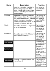
... information available for the remaining segments of the Trip Data fields. Shows the elevation by the GPS receiver. The calculation cannot take into account traffic jams and other possible delays. manually in and the time zone information one of the route. if it is provided Tap this one replaces it . If you tap the previous button, this field to show it on the map screen...
... information available for the remaining segments of the Trip Data fields. Shows the elevation by the GPS receiver. The calculation cannot take into account traffic jams and other possible delays. manually in and the time zone information one of the route. if it is provided Tap this one replaces it . If you tap the previous button, this field to show it on the map screen...
ME Software Manual
Page 90
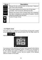
... needed during navigation. This button replaces the previous one if it to resume collecting trip data. Resets all trips. 4.1.8 Quick menu The Quick menu is shown on if its lamp is a multi-value button. It can be opened directly from the GPS. If you tap any of the selected vehicle is a selection of the currently shown trip. Tap it has been activated. The Vehicle type button is restarted only when Nextar Navigation System receives a position from the Map screen...
... needed during navigation. This button replaces the previous one if it to resume collecting trip data. Resets all trips. 4.1.8 Quick menu The Quick menu is shown on if its lamp is a multi-value button. It can be opened directly from the GPS. If you tap any of the selected vehicle is a selection of the currently shown trip. Tap it has been activated. The Vehicle type button is restarted only when Nextar Navigation System receives a position from the Map screen...
ME Software Manual
Page 111
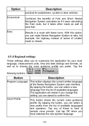
... your local language, measurement units, time and date settings and formats, as well as well to save fuel. Just tap OK when you are asked to confirm this. Button Program Language Voice Profile Description This button displays the current written language of these to customize the application for pedestrians, cyclists or slow vehicles. you have selected the new spoken language. 110 Combines the benefits of available languages. With this setting; By tapping...
... your local language, measurement units, time and date settings and formats, as well as well to save fuel. Just tap OK when you are asked to confirm this. Button Program Language Voice Profile Description This button displays the current written language of these to customize the application for pedestrians, cyclists or slow vehicles. you have selected the new spoken language. 110 Combines the benefits of available languages. With this setting; By tapping...
ME Software Manual
Page 113
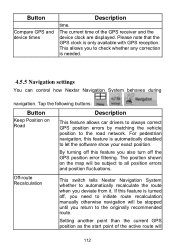
... turn off , you need to the originally recommended route. Button Compare GPS and device times Description time. By turning off this feature is turned off the GPS position error filtering. Setting another point than the current GPS position as the start point of the GPS receiver and the device clock are displayed. Tap the following buttons: , , . For pedestrian navigation, this feature is automatically disabled to check whether any correction is only available with GPS reception. Off-route Recalculation This switch tells Nextar Navigation...
... turn off , you need to the originally recommended route. Button Compare GPS and device times Description time. By turning off this feature is turned off the GPS position error filtering. Setting another point than the current GPS position as the start point of the GPS receiver and the device clock are displayed. Tap the following buttons: , , . For pedestrian navigation, this feature is automatically disabled to check whether any correction is only available with GPS reception. Off-route Recalculation This switch tells Nextar Navigation...
ME Software Manual
Page 116
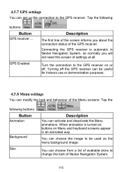
... demonstration purposes. 4.5.8 Menu settings You can modify the look of the Menu screens. Connecting the GPS receiver is turned on, buttons on or off the GPS receiver can choose from a list of available skins to the GPS receiver. Turning off . Tap the following buttons: , Button GPS receiver ... Tap the following buttons: Button Animation Background Skin , , . GPS Enabled , . You can be used as the menu background image. Turn the connection to the GPS receiver on Menu and keyboard screens appear in Nextar Navigation System, so...
... demonstration purposes. 4.5.8 Menu settings You can modify the look of the Menu screens. Connecting the GPS receiver is turned on, buttons on or off the GPS receiver can choose from a list of available skins to the GPS receiver. Turning off . Tap the following buttons: , Button GPS receiver ... Tap the following buttons: Button Animation Background Skin , , . GPS Enabled , . You can be used as the menu background image. Turn the connection to the GPS receiver on Menu and keyboard screens appear in Nextar Navigation System, so...
ME Software Manual
Page 123
... in the "About/Map" menu item of the operating computer program (hereinafter referred to as part of the Software Product. 4.4 Error corrections, additions, updates used by Licensor in Section 2 following the conclusion of this Agreement the Database Owner is represented by the User as defined in relations to utilize and give into further utilization the map database as set forth in this Agreement...
... in the "About/Map" menu item of the operating computer program (hereinafter referred to as part of the Software Product. 4.4 Error corrections, additions, updates used by Licensor in Section 2 following the conclusion of this Agreement the Database Owner is represented by the User as defined in relations to utilize and give into further utilization the map database as set forth in this Agreement...


