Installation Instructions
Page 6
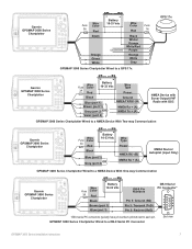
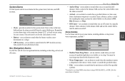
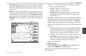
...interface must be installed. Use 22 AWG (18 AWG for the Red and Black wires), shielded, twisted-pair wiring for purchase from: National Marine Electronics Association (NMEA) Seven Riggs Avenue Severna Park, MD 21146 U.S.A. You can input one chartplotter on the network. If two or more chartplotters,...wiring diagram examples showing the GPSMAP 3000 using the 18-pin Power/data cable and the GPS 17x. For third-party devices, refer to three NMEA devices per port. Port 4-is reserved for use with support for the WPL sentence, DSC, and sonar NMEA input with Garmin sounder modules. Solder all...
...interface must be installed. Use 22 AWG (18 AWG for the Red and Black wires), shielded, twisted-pair wiring for purchase from: National Marine Electronics Association (NMEA) Seven Riggs Avenue Severna Park, MD 21146 U.S.A. You can input one chartplotter on the network. If two or more chartplotters,...wiring diagram examples showing the GPSMAP 3000 using the 18-pin Power/data cable and the GPS 17x. For third-party devices, refer to three NMEA devices per port. Port 4-is reserved for use with support for the WPL sentence, DSC, and sonar NMEA input with Garmin sounder modules. Solder all...
Installation Instructions
Page 7
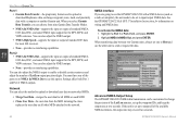
... Fuse Red 1A Unconnected Black White/ Orange White/Red Purple Orange White > Gray GPSMAP 3000 Series Chartplotter Wired to a GPS 17x GPS 17x > > > > > Garmin GPSMAP 3000 Series Chartplotter Wire Fuse Color 3A Red � � Battery 10-33... Vdc Wire Type Power Black > Blue (port 1) Brown (port 1) > Gray (port 2) OR Violet (port 2) Ground NMEA TX/RX- (B) NMEA Rx + (A)> NMEA Tx + (A) NMEA Device with Sonar Output/VHF Radio with DSC GPSMAP...
... Fuse Red 1A Unconnected Black White/ Orange White/Red Purple Orange White > Gray GPSMAP 3000 Series Chartplotter Wired to a GPS 17x GPS 17x > > > > > Garmin GPSMAP 3000 Series Chartplotter Wire Fuse Color 3A Red � � Battery 10-33... Vdc Wire Type Power Black > Blue (port 1) Brown (port 1) > Gray (port 2) OR Violet (port 2) Ground NMEA TX/RX- (B) NMEA Rx + (A)> NMEA Tx + (A) NMEA Device with Sonar Output/VHF Radio with DSC GPSMAP...
Owner's Manual
Page 3
... a GDL 30/ GDL 30A Marine Weather Satellite Receiver with your new chartplotter, read this manual and learn the operating procedures for reference. Installing Your GPSMAP 3206/3210 To install the GPSMAP 3206/3210 refer to use it to create an unsurpassed marine Multi-Function Display (MFD). The GPSMAP 3206/3210 uses the proven performance of Garmin GPS and fullfeatured mapping to...
... a GDL 30/ GDL 30A Marine Weather Satellite Receiver with your new chartplotter, read this manual and learn the operating procedures for reference. Installing Your GPSMAP 3206/3210 To install the GPSMAP 3206/3210 refer to use it to create an unsurpassed marine Multi-Function Display (MFD). The GPSMAP 3206/3210 uses the proven performance of Garmin GPS and fullfeatured mapping to...
Owner's Manual
Page 5
...Page 41 Highway Page 42 Changing the Highway Perspective Range 43 Highway Page Options 43 Video Page...44 Video Page Options 44 Main Menu 45 GPS Tab...45 Tide Tab...46 Tide Sub Tab...46 Current Sub Tab...48 Celestial Tab 49 Trip Tab...50 Weather Tab 51 Points Tab...... Dual Beam...76 Understanding the Sonar Display 77 Sonar Page...78 Configuring the Sonar Page 79 Using the Sonar Adjustment Menu 80 Using the Pointer on the Sonar Page 82 Marking an Underwater Waypoint 82 Sonar Tab...82 General Sub Tab...83 Graph Sub Tab...84 Water Temp Sub Tab 85 GPSMAP 3206/3210 Owner's Manual iii
...Page 41 Highway Page 42 Changing the Highway Perspective Range 43 Highway Page Options 43 Video Page...44 Video Page Options 44 Main Menu 45 GPS Tab...45 Tide Tab...46 Tide Sub Tab...46 Current Sub Tab...48 Celestial Tab 49 Trip Tab...50 Weather Tab 51 Points Tab...... Dual Beam...76 Understanding the Sonar Display 77 Sonar Page...78 Configuring the Sonar Page 79 Using the Sonar Adjustment Menu 80 Using the Pointer on the Sonar Page 82 Marking an Underwater Waypoint 82 Sonar Tab...82 General Sub Tab...83 Graph Sub Tab...84 Water Temp Sub Tab 85 GPSMAP 3206/3210 Owner's Manual iii
Owner's Manual
Page 40
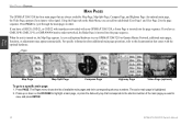
.... If you add optional hardware to your GPSMAP 3206/3210, a Sonar Page is inserted into the page sequence. For specific information about additional main page operations, refer to the documentation that comes with your GPSMAP 3206/3210 or Garmin Marine Network, additional main pages, functions, or adjustments...page is turned on the Main Menu, you want to view, and press ENTER. 32 GPSMAP 3206/3210 Owner's Manual Main Pages > Overview Main Pages The GPSMAP 3206/3210 has four main pages that corresponds to the shortcut number of available main pages and their corresponding...
.... If you add optional hardware to your GPSMAP 3206/3210, a Sonar Page is inserted into the page sequence. For specific information about additional main page operations, refer to the documentation that comes with your GPSMAP 3206/3210 or Garmin Marine Network, additional main pages, functions, or adjustments...page is turned on the Main Menu, you want to view, and press ENTER. 32 GPSMAP 3206/3210 Owner's Manual Main Pages > Overview Main Pages The GPSMAP 3206/3210 has four main pages that corresponds to the shortcut number of available main pages and their corresponding...

Owner's Manual
Page 41
...page: 1. Main page Second map Compass Digital 1 Highway Page Main Pages Configuration Window GPSMAP 3206/3210 Owner's Manual Map Page with a check mark in the check box to the left... of data that is shown in the upper-left side (two or three function windows) or in each data field. You can also display other functions, such as a compass, temperature log (if inputting Garmin or NMEA sonar... to fit your GPSMAP 3206/3210 or Garmin Marine Network, additional function choices might appear automatically.
...page: 1. Main page Second map Compass Digital 1 Highway Page Main Pages Configuration Window GPSMAP 3206/3210 Owner's Manual Map Page with a check mark in the check box to the left... of data that is shown in the upper-left side (two or three function windows) or in each data field. You can also display other functions, such as a compass, temperature log (if inputting Garmin or NMEA sonar... to fit your GPSMAP 3206/3210 or Garmin Marine Network, additional function choices might appear automatically.
Owner's Manual
Page 49
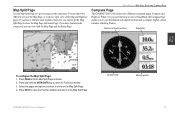
.../3210 features two different navigation pages: Compass and Highway. Press PAGE until the Map Split Page is shown. 2. Select the pages and options you can set up the Map Split Page to show the Map Page and Sonar Page; if you have a Garmin sonar module connected, you ...want to view two pages at the same time. Press QUIT to close the Function window and return to your destination with digital readouts and a compass display, which includes a Bearing Pointer. Compass ring Bearing pointer GPSMAP 3206/3210 Owner...
.../3210 features two different navigation pages: Compass and Highway. Press PAGE until the Map Split Page is shown. 2. Select the pages and options you can set up the Map Split Page to show the Map Page and Sonar Page; if you have a Garmin sonar module connected, you ...want to view two pages at the same time. Press QUIT to close the Function window and return to your destination with digital readouts and a compass display, which includes a Bearing Pointer. Compass ring Bearing pointer GPSMAP 3206/3210 Owner...
Owner's Manual
Page 66
The Alarms tab is visible. To set additional alarms, and then press ENTER when finished. 58 GPSMAP 3206/3210 Owner's Manual Highlight the field next to the alarm you want to set, and press ENTER. 3. Change the mode to set an alarm: 1. Alarms Tab...when each message occurred is shown at the bottom of messages generated by the GPSMAP 3206/3210. If you have a GDL 30/30A Marine Weather Satellite Receiver connected, the Weather sub tab is divided into three sub tabs: System, Nav, and Sonar. The status bar and data field remain red while the alarm condition persists...
The Alarms tab is visible. To set additional alarms, and then press ENTER when finished. 58 GPSMAP 3206/3210 Owner's Manual Highlight the field next to the alarm you want to set, and press ENTER. 3. Change the mode to set an alarm: 1. Alarms Tab...when each message occurred is shown at the bottom of messages generated by the GPSMAP 3206/3210. If you have a GDL 30/30A Marine Weather Satellite Receiver connected, the Weather sub tab is divided into three sub tabs: System, Nav, and Sonar. The status bar and data field remain red while the alarm condition persists...
Owner's Manual
Page 67
...off from a destination waypoint is too shallow or too deep. GPSMAP 3206/3210 Owner's Manual 59 The unit must be on and off . Enter a distance, radius, or time for your system. You must be receiving sonar data for the sonar alarms to sound when the transducer reports a temperature either above, ... work . • Battery-sets an alarm to sound when the battery reaches a userdetermined low voltage. • GPS Accuracy-sets an alarm to sound when the GPS location accuracy falls outside the specified values. • Fish -sets an alarm to sound when the unit detects a fish...
...off from a destination waypoint is too shallow or too deep. GPSMAP 3206/3210 Owner's Manual 59 The unit must be on and off . Enter a distance, radius, or time for your system. You must be receiving sonar data for the sonar alarms to sound when the transducer reports a temperature either above, ... work . • Battery-sets an alarm to sound when the battery reaches a userdetermined low voltage. • GPS Accuracy-sets an alarm to sound when the GPS location accuracy falls outside the specified values. • Fish -sets an alarm to sound when the unit detects a fish...

Owner's Manual
Page 70
Datums are available, you should change the datum only if you enter. • GPSMAP 3206/3210 Owner's Manual Although more than 100 datums are used to describe geographic locations for this data to appear. • Heading-sets the reference used ...in the unit. True provides headings based on the variation you are not actual maps built in substantial position errors. You must be receiving NMEA Sonar depth data or using a Garmin Sonar Module for the Temperature to appear. • Distance, Speed, and Elevation-set the units of measure for temperature in calculating heading ...
Datums are available, you should change the datum only if you enter. • GPSMAP 3206/3210 Owner's Manual Although more than 100 datums are used to describe geographic locations for this data to appear. • Heading-sets the reference used ...in the unit. True provides headings based on the variation you are not actual maps built in substantial position errors. You must be receiving NMEA Sonar depth data or using a Garmin Sonar Module for the Temperature to appear. • Distance, Speed, and Elevation-set the units of measure for temperature in calculating heading ...
Owner's Manual
Page 72
... set up the waypoint IDs, and keep the output rate at two seconds. See the GPSMAP 3206/3210 & GPS 17 Installation Instructions for the DPT, MTW, and VHW sentences. When transferring data between two Garmin units, always set to NMEA In/NMEA Out to the network. If the unit is ...the user data for all MFDs on wiring and NMEA data. When you select Garmin Data Transfer, you are going to change the precision of standard NMEA 0183 data, DSC, and sonar NMEA input support for most AIS receivers. • None-provides no interfacing capabilities. Settings affect both Port 1 and ...
... set up the waypoint IDs, and keep the output rate at two seconds. See the GPSMAP 3206/3210 & GPS 17 Installation Instructions for the DPT, MTW, and VHW sentences. When transferring data between two Garmin units, always set to NMEA In/NMEA Out to the network. If the unit is ...the user data for all MFDs on wiring and NMEA data. When you select Garmin Data Transfer, you are going to change the precision of standard NMEA 0183 data, DSC, and sonar NMEA input support for most AIS receivers. • None-provides no interfacing capabilities. Settings affect both Port 1 and ...

Owner's Manual
Page 80
The Sonar Page appears only if you have the unit automatically determine the best range, or select a span of 2, 4, 6, 8, or 10 degrees. See the "Using Radar" section ... right side of time. Use the Reset button in Auto mode to 2.5 hours. 72 GPSMAP 3206/3210 Owner's Manual Temp (Temperature) Tab The Temp tab displays the water temperature log (if equipped with a temperature sensing transducer or receiving NMEA Sonar temperature data). Select a duration from right to have the Radar check box selected on...
The Sonar Page appears only if you have the unit automatically determine the best range, or select a span of 2, 4, 6, 8, or 10 degrees. See the "Using Radar" section ... right side of time. Use the Reset button in Auto mode to 2.5 hours. 72 GPSMAP 3206/3210 Owner's Manual Temp (Temperature) Tab The Temp tab displays the water temperature log (if equipped with a temperature sensing transducer or receiving NMEA Sonar temperature data). Select a duration from right to have the Radar check box selected on...

Owner's Manual
Page 81
...and Highway Tab Highway Tab Use the Highway tab to select or clear options. GPSMAP 3206/3210 Owner's Manual 73 The Sonar Page appears only if you have the Sonar check box selected on page 76 for the Sonar Page. Main Menu • Active Route Waypoints-show all active route waypoints. ...• User Waypoints-show only nearby waypoints. • Track Log-show current active track log. • Saved Tracks-show any saved track logs. See the "Using Sonar" section on the System...
...and Highway Tab Highway Tab Use the Highway tab to select or clear options. GPSMAP 3206/3210 Owner's Manual 73 The Sonar Page appears only if you have the Sonar check box selected on page 76 for the Sonar Page. Main Menu • Active Route Waypoints-show all active route waypoints. ...• User Waypoints-show only nearby waypoints. • Track Log-show current active track log. • Saved Tracks-show any saved track logs. See the "Using Sonar" section on the System...
Owner's Manual
Page 84
...sonar features. The following section provides a general overview of the transducer and the water depth. The transducer receives the sound wave information, and then sends the information to the GSD 20, GSD 21, or GSD 22 sounder module and then to help you need to know to the GPSMAP 3206/3210... the beam covers more area (for example, at any object that you to use the sonar functionality of about what is under your boat, and is underneath your GPSMAP 3306/3210. The GPSMAP 3206/3210 displays the information on your sounder to see the best picture available at a 30-foot ...
...sonar features. The following section provides a general overview of the transducer and the water depth. The transducer receives the sound wave information, and then sends the information to the GSD 20, GSD 21, or GSD 22 sounder module and then to help you need to know to the GPSMAP 3206/3210... the beam covers more area (for example, at any object that you to use the sonar functionality of about what is under your boat, and is underneath your GPSMAP 3306/3210. The GPSMAP 3206/3210 displays the information on your sounder to see the best picture available at a 30-foot ...

Owner's Manual
Page 85
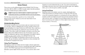
...the water, much wider view of the screen. The beam starts small near your boat. The GPSMAP 3206/3210 includes the latest technology in the weakest colors). Using Sonar > Understanding Sonar At the top of a flashlight. This area is the continuous, intensely-colored line running across ... readings. Too much like the beam of the screen, you might not always appear as arches. Hard Structure Soft Structure Sonar GPSMAP 3206/3210 Owner's Manual 77 The Sonar Page does not show a 3-D representation of approximately a 20-foot circle. Instead, the display is the default). The ...
...the water, much wider view of the screen. The beam starts small near your boat. The GPSMAP 3206/3210 includes the latest technology in the weakest colors). Using Sonar > Understanding Sonar At the top of a flashlight. This area is the continuous, intensely-colored line running across ... readings. Too much like the beam of the screen, you might not always appear as arches. Hard Structure Soft Structure Sonar GPSMAP 3206/3210 Owner's Manual 77 The Sonar Page does not show a 3-D representation of approximately a 20-foot circle. Instead, the display is the default). The ...

Owner's Manual
Page 86
... water (if equipped with a temperature or speed sensor). 78 Sonar Page with Split Screen GPSMAP 3206/3210 Owner's Manual The most recent data is selected on the System tab. Sonar Depth line The sonar function window contains a right-to view the actual sonar data, fish symbols, or a combination of the area being shown... your boat. If a GSD 20, GSD 21, or GSD 22 sounder module is not attached, the Sonar Page appears only when the GPSMAP 3206/3210 is in Simulator Mode or if the Sonar check box is shown on the other half. The right side of the screen contains a scale reflecting the...
... water (if equipped with a temperature or speed sensor). 78 Sonar Page with Split Screen GPSMAP 3206/3210 Owner's Manual The most recent data is selected on the System tab. Sonar Depth line The sonar function window contains a right-to view the actual sonar data, fish symbols, or a combination of the area being shown... your boat. If a GSD 20, GSD 21, or GSD 22 sounder module is not attached, the Sonar Page appears only when the GPSMAP 3206/3210 is in Simulator Mode or if the Sonar check box is shown on the other half. The right side of the screen contains a scale reflecting the...

Owner's Manual
Page 87
... prefer the appearance of what is wider. Press QUIT to return to them appear on page 33 for the Sonar Page. GPSMAP 3206/3210 Owner's Manual 79 It provides an almost instantaneous return of flasher sonars, select the Flasher function on the Configuration window for more faint. • A hard bottom (such as sand or...
... prefer the appearance of what is wider. Press QUIT to return to them appear on page 33 for the Sonar Page. GPSMAP 3206/3210 Owner's Manual 79 It provides an almost instantaneous return of flasher sonars, select the Flasher function on the Configuration window for more faint. • A hard bottom (such as sand or...
Owner's Manual
Page 88
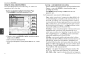
... kHz). • Whiteline-controls how the unit shows information about the bottom type (hard or soft). To exit any of the sonar receiver. The Sonar adjustment menu contains the following options: • Gain-controls the sensitivity of the adjustment options, press the Back soft key, or .... 80 To change a Sonar adjustment menu setting: 1. To turn the Whiteline off, press the ROCKER down on the ROCKER to access the settings and features most commonly used on the screen, increase the receiver sensitivity by selecting a higher gain. GPSMAP 3206/3210 Owner's Manual You can set...
... kHz). • Whiteline-controls how the unit shows information about the bottom type (hard or soft). To exit any of the sonar receiver. The Sonar adjustment menu contains the following options: • Gain-controls the sensitivity of the adjustment options, press the Back soft key, or .... 80 To change a Sonar adjustment menu setting: 1. To turn the Whiteline off, press the ROCKER down on the ROCKER to access the settings and features most commonly used on the screen, increase the receiver sensitivity by selecting a higher gain. GPSMAP 3206/3210 Owner's Manual You can set...
Owner's Manual
Page 89
... Lock, the Span setting adjusts how far off the bottom the unit shows data. • Tools-controls the display of useful sonar tools. Sonar GPSMAP 3206/3210 Owner's Manual 81 The following options are available: • Off-turns off , press the ROCKER up RANGE key to decrease ...a scroll rate from 90% to left. Ultrascroll™ (default) is all the way at the bottom of a zoomed display. Depth line Using Sonar > Sonar Page • Zoom-sets a screen zoom scale. The following settings are available: • A-scope-when you have a temperature-capable transducer. When...
... Lock, the Span setting adjusts how far off the bottom the unit shows data. • Tools-controls the display of useful sonar tools. Sonar GPSMAP 3206/3210 Owner's Manual 81 The following options are available: • Off-turns off , press the ROCKER up RANGE key to decrease ...a scroll rate from 90% to left. Ultrascroll™ (default) is all the way at the bottom of a zoomed display. Depth line Using Sonar > Sonar Page • Zoom-sets a screen zoom scale. The following settings are available: • A-scope-when you have a temperature-capable transducer. When...
Owner's Manual
Page 90
... or GSD 22 is paused, but the unit does not show any changes, and press ENTER when finished. 4. Press the Sonar Setup soft key to the location you want . 2. Sonar 82 GPSMAP 3206/3210 Owner's Manual On the Sonar Page, use an object such as a stump as a future fishing location. To change a setting on the...
... or GSD 22 is paused, but the unit does not show any changes, and press ENTER when finished. 4. Press the Sonar Setup soft key to the location you want . 2. Sonar 82 GPSMAP 3206/3210 Owner's Manual On the Sonar Page, use an object such as a stump as a future fishing location. To change a setting on the...


