Garmin GPSMAP 431s Support Question
Garmin GPSMAP 431s Support Question
Find answers below for this question about Garmin GPSMAP 431s.Need a Garmin GPSMAP 431s manual? We have 8 online manuals for this item!
Question posted by sgower on June 22nd, 2013
Sonar Symbols
What is the difference between a red fish and blue fish symbol on the sonar screen?
Current Answers


Related Garmin GPSMAP 431s Manual Pages
Installation Instructions - Page 6
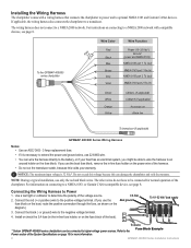
.../500 Series Wiring Harness
Notes: • Use an AGC/ 3AG - 3 Amp replacement fuse.
• If it is 32 Vdc*.
To the GPSMAP 400/500 series chartplotter
3FAuse
Wire Color
Red
Black
>
Blue
Brown
>
Grey
Violet
Wire Function
Power (10-32 Vdc*) Ground
(power and NMEA 0183) NMEA 0183 port 1 Tx (out)
NMEA 0183...
Installation Instructions - Page 9
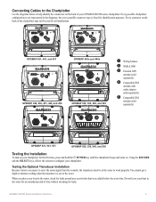
... Installation Instructions Using the ROCKER and the SELECT keys, follow the screens to configure your GPSMAP 400/500 series chartplotter. Every possible chartplotter
configuration is not represented in the diagrams, but every possible connector type is necessary to carry the sonar signal from the sounder, the transducer must be used for all installations...
Installation Instructions - Page 10

...to 55ºC)
Compass-Safe Distances:
Model Number
GPSMAP 526/536/546/556 GPSMAP 421/431/441/451 GPSMAP 521/531/541/551 GPSMAP 420/430/440/450 GPSMAP 520/530/540/550/525/535/545/555
Compass-... (75 cm)
38 in . GPSMAP 526/536/546/556 (s): High-sensitivity 12 parallel channel WAAS-capable receiver. Update Rate: 1/second, continuous
GPS Accuracy: Position: If the sonar signal suddenly is lost . If ...
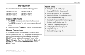
Quick Reference Guide - Page 1

... 1. From the Home screen, select Charts > Navigation Chart.
2. To delete a waypoint or an MOB: 1. Finding a Marine Service and Navigating to...shown when more than one waypoint is in the vicinity.)
GPSMAP® 400/500 series
quick reference guide Create a Waypoint
... as an MOB point.
Press SELECT to change (Name, Symbol, Depth, Water Temp,
Comment, or Position). Select the ...
Owner's Manual - Page 3
... 48. • Using Sonar: page 57. • Alarms and Messages: page 79. Then highlight Navigation Chart, and press SELECT again. GPSMAP 400/500 Series Owner's...GPSMAP® 431/431s GPSMAP 531/531s GPSMAP 541/541s
GPSMAP 441/441s GPSMAP 536/536s GPSMAP 546/546s
Tips and Shortcuts
• Press HOME from any screen to return to the Home screen.
• Press MENU from any of items on the screen...
Owner's Manual - Page 4
... Using Perspective 3D 15
ii
Using Mariner's Eye 3D 16 Using Fish Eye 3D 18 Using Fishing Charts 19 Enabling High Resolution Satellite Imagery 19 Viewing Aerial Photos 20 Animated Tide and Current Indicators 21 Detailed Road and POI Data 21 Using Automatic Guidance 22 Using the Chart/Sonar Screen 22 Automatic Identification System 22...
Owner's Manual - Page 24
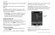
... if the chartplotter is connected to a weather module and you have an "s" series unit (such as fish). Note: You must have an XM subscription.) See page 68 for the Fish Eye 3D screen, press MENU. Fish Symbols (only available if sonar is present)-displays suspended targets (such as a GPSMAP 441s) with a connected transducer to adjust the view.
Owner's Manual - Page 28
...
GPSMAP 400/500 Series Owner's Manual
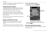
If Auto Guidance must calculate a route close to potentially dangerous points, those points are outlined in red, and a message appears informing you to view the Navigation chart, Fishing chart, Mariner's Eye 3D, or Fish Eye 3D and sonar at the same time. Navigation chart screen
Sonar screen
Using the Chart/Sonar Screen
Note: The Chart/Sonar screen...
Owner's Manual - Page 66
...symbol is displayed. The target depth of fish symbols, whiteline, and the sonar color scheme.
• Fish Symbols-set the depth of the water. Suspended targets appear as symbols with no background information shown. GPSMAP...scroll speed automatically adjust to all sonar screens. Suspended targets appear as symbols.
From the Home screen, select Sonar > Sonar Setup. Surface Noise-show or ...
Owner's Manual - Page 67
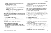
Color Scheme-select White or Blue. Gain-controls the sensitivity of the full screen.
GPSMAP 400/500 Series Owner's Manual 61
Use the Rocker to position the pointer over the fish or structure
you want to adjust manually, Manual). Frequency-when using a dual frequency transducer, select how the frequencies appear on all strong returns are...
Owner's Manual - Page 84
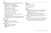
GPS Accuracy: Position:
Appendix
Acquisition Times: (Average acquisition times for a stationary receiver with a clear view of the sky) GPSMAP 431/431s GPSMAP 441/441s GPSMAP 531/531s GPSMAP 541/541s
Warm:* Approximately 1 second Cold:** Approximately 38 seconds
GPSMAP 536/536s GPSMAP 546/546s
Warm:* Approximately 15 seconds Cold:** Approximately 38 seconds
*Warm: your unit is at or near the last...
Owner's Manual - Page 91

...
Calibrate Water Speed 55 celestial information 43 Chart/Sonar screen
using 22 Chart Borders 14 chart data 10 charts
detail 13 fish eye 3D 18 fishing 19 mariner's eye 3D 16 navigation 8 settings 12 cleaning...symbols 23 threats 27 alarms 52, 79-82 anchor drag 53 arrival 53 battery 53 clock 53 collision 26 deep water 53 fish 54 fuel 54 GPS accuracy 53 navigation 53 off course 53 shallow water 53 sonar...
Owner's Manual - Page 92
...Fish Symbols 18, 60 flasher 57 forecast information 72 frequency 61 Fuel Capacity 56 fuel gauges
synchronizing 40 viewing 40 full screen, sonar 57 Full Screen Map 9 fuse 78
G
gain 61 Garmin Data Transfer 51 go to 28 GPS 5, 48, 78 GPS...map datum 49 MapSource data 44 Mariner's Eye 3D
AIS 27 MARPA 27 mariner's eye 3D colors 17 mark ...links i
GPSMAP 400/500 Series Owner's Manual Precision 51 Power/Backlight ...
Owner's Manual - Page 4
... Using Perspective 3D 15
ii
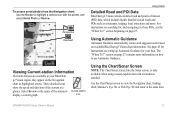
Using Mariner's Eye 3D 16 Using Fish Eye 3D 18 Using Fishing Charts 19 Enabling High Resolution Satellite Imagery 19 Viewing Aerial Photos 20 Viewing Current-station Information 21 Detailed Road and POI Data 21 Using Automatic Guidance 21 Using the Chart/Sonar Screen 21 Automatic Identification System 22
Where...
Owner's Manual - Page 24
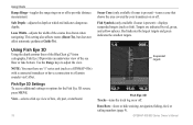
... 3D Settings To access additional settings or options for the Fish Eye 3D screen, press MENU. Data Bars-show or hide cruising, navigation, fishing, fuel, or sailing numbers (page 9). Fish Symbols (only available if sonar is present)-turns a cone that shows the area covered by red, green, and yellow spheres.
This setting also affects routes (Route To...
Owner's Manual - Page 27
... select Aerial Photo or Review. GPSMAP 400/500 Series Owner's Manual
21
The "Where To?" These detailed icons
show the speed and direction of the station to Current-station
display a current graph.
Use the Chart/Sonar screen to view the Navigation chart, Fishing chart, Mariner's Eye 3D, or Fish Eye 3D and sonar at a
glance. section beginning...
Owner's Manual - Page 28
...chart/sonar screen, press MENU.
Sonar screen
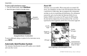
Navigation/Sonar Combination
To access additional settings or options for each vessel includes the Maritime Mobile Service Identity (MMSI), the location, the GPS speed, the GPS heading...target
Closest point and time of chart on the Navigation Chart
GPSMAP 400/500 Series Owner's Manual Automatic Identification System
The Automatic Identification System (...
Owner's Manual - Page 58
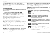
... clutter. Hide surface noise to left corner.
Surface Noise-show or hide the sonar returns near the surface of the screen.
52
GPSMAP 400/500 Series Owner's Manual A-Scope-display a vertical flasher along the bottom.
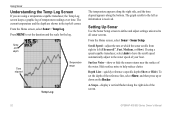
Setting Up Sonar
Use the Sonar Setup screen to define and adjust settings universal to the water speed of temperature readings...
Owner's Manual - Page 59
... mark a waypoint at a selected depth: 1. Suspended targets appear as symbols.
Color Scheme-select White or Blue. GPSMAP 400/500 Series Owner's Manual
Using Sonar
• Whiteline-highlights the strongest signal from the bottom to mark. 3. No background information appears.
From the paused screen, press MENU > Resume Sonar to display the values. Data Bars-show or hide...
Owner's Manual - Page 83
... 3D 18
settings 18 fishing chart 19
AIS 26 MARPA 26 fishing information 65 Fish Symbols 18, 53 forecast information 64 frequency 54 Fuel Capacity 48 fuel gauges 35 full screen, sonar 50 fuse 70
G
gain 54 Garmin Data Transfer 44 gauges, fuel 35 go to 27 GPS 5, 41, 70 Grid (North) 42 guide to 27
H
Hazard...
Similar Questions

How Do I Go Into Simulation Mode On A Garmin Marine Gps Modle741xs
how do I use simulation mode on a garmin 741xs marine ver
how do I use simulation mode on a garmin 741xs marine ver
(Posted by Curthupp 6 years ago)

Fish Size
does the blue or orange fish symbol on the 421s represent fish size
does the blue or orange fish symbol on the 421s represent fish size
(Posted by Nrjbigdog 8 years ago)
Water Temperature Not Showing On Gpsmap 431s.
Water temperature was showing when the unit was installed. the unit is removed from the boat during ...
Water temperature was showing when the unit was installed. the unit is removed from the boat during ...
(Posted by tbuckland2 8 years ago)


541s Marine Gps. Depth Not Reading Out.
Depth has been working since installed. Now blank. Is there an on off control for this that may have...
Depth has been working since installed. Now blank. Is there an on off control for this that may have...
(Posted by therad50 11 years ago)