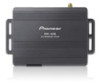
Owner's Manual
Page 2
... agreement 6 - route settings screen) 20 Operating the on-screen keyboard 20 Monitoring the GPS reception quality 21 How to operate your model properly. Viewing information about the current position 24 Browsing the data field 25 Display during freeway driving 25 Operating the map screen 26 - Smart Zoom 26 - Changing the view angle of Interest (POI) 32 - Scrolling the map to the position you will know how to use the navigation menu screens Screen switching overview 19...
... agreement 6 - route settings screen) 20 Operating the on-screen keyboard 20 Monitoring the GPS reception quality 21 How to operate your model properly. Viewing information about the current position 24 Browsing the data field 25 Display during freeway driving 25 Operating the map screen 26 - Smart Zoom 26 - Changing the view angle of Interest (POI) 32 - Scrolling the map to the position you will know how to use the navigation menu screens Screen switching overview 19...
Owner's Manual
Page 3
... 54 Setting the volume and the guidance voice for navigation system 54 Customizing the quick menu 55 Setting the traffic information 56 Setting the user profiles 57 Customizing the map screen settings 57 Setting the visual guidance 58 Customizing the display settings 59 Customizing the regional settings 60 Setting the Trip Monitor 60 Starting the configuration wizard 60 Resetting to your destination 39 - Setting a route using a searched location 39 - Selecting a new destination when a route is decided Setting a route to the default settings 61 Other operations More menu 62 Installation...
... 54 Setting the volume and the guidance voice for navigation system 54 Customizing the quick menu 55 Setting the traffic information 56 Setting the user profiles 57 Customizing the map screen settings 57 Setting the visual guidance 58 Customizing the display settings 59 Customizing the regional settings 60 Setting the Trip Monitor 60 Starting the configuration wizard 60 Resetting to your destination 39 - Setting a route using a searched location 39 - Selecting a new destination when a route is decided Setting a route to the default settings 61 Other operations More menu 62 Installation...
Owner's Manual
Page 12
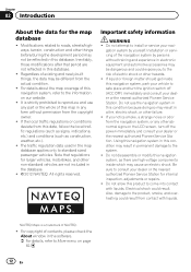
... electric shock. Also, damage to roads, streets/highways, terrain, construction and other hazards. ! Modifications related to the product, smoke, and overheating could result from the copyright owner. ! The traffic regulation data used in the database. ! © 2012 NAVTEQ. NAVTEQ Maps is strictly prohibited to install or service your dealer or the nearest authorized Pioneer Service Station. Note that period are not...
... electric shock. Also, damage to roads, streets/highways, terrain, construction and other hazards. ! Modifications related to the product, smoke, and overheating could result from the copyright owner. ! The traffic regulation data used in the database. ! © 2012 NAVTEQ. NAVTEQ Maps is strictly prohibited to install or service your dealer or the nearest authorized Pioneer Service Station. Note that period are not...
Owner's Manual
Page 13
... time when the route was calculated is for your vehicle. Pay close attention to read and understood the operating instructions. ! Introduction Chapter 02 Introduction CAUTION When a route is calculated, the route and voice guidance for the route are disabled unless the vehicle is stopped and/or the parking brake is applied. ! Read the entire manual before making the necessary adjustments. ! Route and guidance information displayed by the navigation...
... time when the route was calculated is for your vehicle. Pay close attention to read and understood the operating instructions. ! Introduction Chapter 02 Introduction CAUTION When a route is calculated, the route and voice guidance for the route are disabled unless the vehicle is stopped and/or the parking brake is applied. ! Read the entire manual before making the necessary adjustments. ! Route and guidance information displayed by the navigation...
Owner's Manual
Page 15
... memory card out of the reach of trouble Should the navigation system fail to operate properly, contact your product. 2 Receive updates on the storage device for damages, costs or expenses arising from data loss or corruption. ! En 15 Using this product in this product. WARNING Do not install this product without running the engine can damage the SD memory card. The names of software upgrades and software updates...
... memory card out of the reach of trouble Should the navigation system fail to operate properly, contact your product. 2 Receive updates on the storage device for damages, costs or expenses arising from data loss or corruption. ! En 15 Using this product in this product. WARNING Do not install this product without running the engine can damage the SD memory card. The names of software upgrades and software updates...
Owner's Manual
Page 16
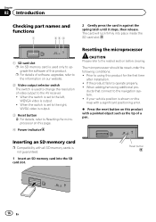
... to the navigation system. ! ducts that connect to operate properly. ! Inserting an SD memory card p Compatibility with a significant positioning error. % Press the reset button on our website. 2 Video output selector switch The switch is output. 3 Reset button = For details, refer to Resetting the microprocessor on this product with a pointed object such as the tip of software upgrades, refer to the information on this page. 4 Power indicator Resetting the microprocessor...
... to the navigation system. ! ducts that connect to operate properly. ! Inserting an SD memory card p Compatibility with a significant positioning error. % Press the reset button on our website. 2 Video output selector switch The switch is output. 3 Reset button = For details, refer to Resetting the microprocessor on this product with a pointed object such as the tip of software upgrades, refer to the information on this page. 4 Power indicator Resetting the microprocessor...
Owner's Manual
Page 20
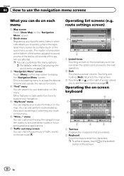
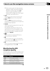
... the device. Chapter 04 How to use the navigation menu screens What you can do on each menu 1 Map screen Touch [Show Map] on the "Navigation Menu" screen. 2 Quick menu Registering your route information on the map. p You can check the summary of this system are entered. 2 Keyboard Touch the keys to enter the characters. You can also perform route-related actions such as editing or canceling your destination on the set route. Operating list screens (e.g. All sounds of traffic events...
... the device. Chapter 04 How to use the navigation menu screens What you can do on each menu 1 Map screen Touch [Show Map] on the "Navigation Menu" screen. 2 Quick menu Registering your route information on the map. p You can check the summary of this system are entered. 2 Keyboard Touch the keys to enter the characters. You can also perform route-related actions such as editing or canceling your destination on the set route. Operating list screens (e.g. All sounds of traffic events...
Owner's Manual
Page 21
... to the map screen. 4 More Touching [More] switches to another keyboard layout, for example from an English keyboard to a Greek keyboard. 5 Results Touch to finalize the keyboard entry (open the list of the text is in lower case. Indicator : : : : Meaning GPS navigation possible Insufficient GPS navigation GPS navigation not possible No connection to GPS receiver Chapter 04 En 21 How to use the navigation menu screens p When entering text, the...
... to the map screen. 4 More Touching [More] switches to another keyboard layout, for example from an English keyboard to a Greek keyboard. 5 Results Touch to finalize the keyboard entry (open the list of the text is in lower case. Indicator : : : : Meaning GPS navigation possible Insufficient GPS navigation GPS navigation not possible No connection to GPS receiver Chapter 04 En 21 How to use the navigation menu screens p When entering text, the...
Owner's Manual
Page 24
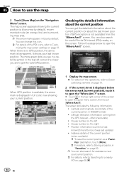
The map screen appears showing the current position (a blue arrow by default. screen. Latitude and longitude (coordinate of the current position in the top right corner of the POI icons, refer to get the detailed information about the current position (or about the last known position if GPS reception is displayed below to open the quick menu screen, then touch [Where Am I ?" Chapter 05 How to Searching for a nearby POI on...
The map screen appears showing the current position (a blue arrow by default. screen. Latitude and longitude (coordinate of the current position in the top right corner of the POI icons, refer to get the detailed information about the current position (or about the last known position if GPS reception is displayed below to open the quick menu screen, then touch [Where Am I ?" Chapter 05 How to Searching for a nearby POI on...
Owner's Manual
Page 25
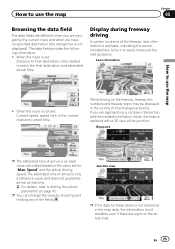
... use the map ! Lane information How to final destination, time needed information exists, the map is an ideal value calculated based on the freeway, freeway exit numbers and freeway signs may be in the vicinity of the current road and current time While driving on the value set : Distance to use the map Chapter 05 Browsing the data field The data fields are different when you are navigating the current route...
... use the map ! Lane information How to final destination, time needed information exists, the map is an ideal value calculated based on the freeway, freeway exit numbers and freeway signs may be in the vicinity of the current road and current time While driving on the value set : Distance to use the map Chapter 05 Browsing the data field The data fields are different when you are navigating the current route...
Owner's Manual
Page 26
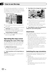
... to Setting a route using the "My Route" menu on page 40. p Map scaling has a limit in two ways: ! Smart Zoom Your navigation system features "Smart Zoom" that works in 3D map view mode. If the next turn , it will zoom in and raise the view angle to let you easily recognize your maneuver at the next junction. When the route is displayed on the screen with street names...
... to Setting a route using the "My Route" menu on page 40. p Map scaling has a limit in two ways: ! Smart Zoom Your navigation system features "Smart Zoom" that works in 3D map view mode. If the next turn , it will zoom in and raise the view angle to let you easily recognize your maneuver at the next junction. When the route is displayed on the screen with street names...
Owner's Manual
Page 40
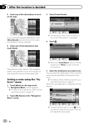
... Screen switching overview on page 19. 2 Touch [My Route] on the map screen. The previous screen returns. When the new destination is decided 5 Touch any of the alternatives to see it is the current GPS position, is not displayed, touch [More] to open a list with different routing methods. 6 Select one of the operations, refer to Selecting a location you cannot find a good alternative, touch [More Results] and scroll down for recently on the map. 3 Touch [Create Route...
... Screen switching overview on page 19. 2 Touch [My Route] on the map screen. The previous screen returns. When the new destination is decided 5 Touch any of the alternatives to see it is the current GPS position, is not displayed, touch [More] to open a list with different routing methods. 6 Select one of the operations, refer to Selecting a location you cannot find a good alternative, touch [More Results] and scroll down for recently on the map. 3 Touch [Create Route...
Owner's Manual
Page 42
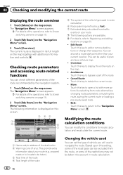
... Changing the vehicle used in route calculation 6 Route planning method (e.g. Back: Touch this key to plan and save a future map. ! Fast) 7 Estimated delay calculated from the route, or some of the road types can check different parameters of the operations, refer to open a list with additional information and controls. The current route is displayed on the "Navigation Menu" screen. 3 Touch [Overview]. unpaved roads or toll roads to be useful to add or remove destinations or change their sequence. Edit Route: Touch...
... Changing the vehicle used in route calculation 6 Route planning method (e.g. Back: Touch this key to plan and save a future map. ! Fast) 7 Estimated delay calculated from the route, or some of the road types can check different parameters of the operations, refer to open a list with additional information and controls. The current route is displayed on the "Navigation Menu" screen. 3 Touch [Overview]. unpaved roads or toll roads to be useful to add or remove destinations or change their sequence. Edit Route: Touch...
Owner's Manual
Page 46
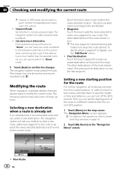
... current route p Carpool or HOV lanes can be used if a given number of passengers are traveling in time and distance, you can turn off the GPS receiver. Final Destination: Touch this key to add the newly selected location as a waypoint to your route compared to the best green alternative on the "Navigation Menu" screen. ! Setting a new starting point of the route to a different location than the selected method, you can quickly switch to "Green" mode. 5 Touch [Back] to Screen switching...
... current route p Carpool or HOV lanes can be used if a given number of passengers are traveling in time and distance, you can turn off the GPS receiver. Final Destination: Touch this key to add the newly selected location as a waypoint to your route compared to the best green alternative on the "Navigation Menu" screen. ! Setting a new starting point of the route to a different location than the selected method, you can quickly switch to "Green" mode. 5 Touch [Back] to Screen switching...
Owner's Manual
Page 50
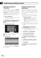
... download more from our website, or save the time and effort of the operations, refer to Setting the volume and the guidance voice for navigation system on page 54. 1 Touch [Menu] on page 19. 2 Touch [More...], then [Settings]. 3 Touch [Sound and Warnings]. 4 Touch [Alert Point Settings]. 5 Touch [Alert Point Warnings], then [Turn On]. 6 Scroll the map and select a location. You can include your home location, favorite places, destinations you have already registered and any map location as an alert point (a speed camera...
... download more from our website, or save the time and effort of the operations, refer to Setting the volume and the guidance voice for navigation system on page 54. 1 Touch [Menu] on page 19. 2 Touch [More...], then [Settings]. 3 Touch [Sound and Warnings]. 4 Touch [Alert Point Settings]. 5 Touch [Alert Point Warnings], then [Turn On]. 6 Scroll the map and select a location. You can include your home location, favorite places, destinations you have already registered and any map location as an alert point (a speed camera...

Owner's Manual
Page 56
...: Displays the GPS information screen with a previously saved route. ! This locally stored information can switch to the TMC function and are given. ! Detour: This setting determines how this key. Simulate Navigation: Displays the map screen and starts simulating the active route. ! The following items (Detour, and Event types) are all related to enable or disable historical traffic data and traffic patterns by touching this system uses the received real-time traffic information in the route calculation. 1 Display the settings screen. = For details of your trip logs...
...: Displays the GPS information screen with a previously saved route. ! This locally stored information can switch to the TMC function and are given. ! Detour: This setting determines how this key. Simulate Navigation: Displays the map screen and starts simulating the active route. ! The following items (Detour, and Event types) are all related to enable or disable historical traffic data and traffic patterns by touching this system uses the received real-time traffic information in the route calculation. 1 Display the settings screen. = For details of your trip logs...
Owner's Manual
Page 57
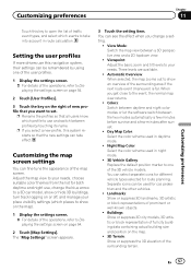
...: Replace the default position marker to one of the user profiles. 1 Display the settings screen. = For details of the operations, refer to Displaying the settings screen on page 54. 2 Touch [User Profiles]. 3 Touch the key on page 54. 2 Touch [Map Settings]. Three levels are available. ! Separate icons can select separate icons for different vehicle types selected for car, pedestrian and the other vehicles. ! En 57 Customizing preferences Chapter 11 Customizing preferences Touch this key to open the list of traffic...
...: Replace the default position marker to one of the user profiles. 1 Display the settings screen. = For details of the operations, refer to Displaying the settings screen on page 54. 2 Touch [User Profiles]. 3 Touch the key on page 54. 2 Touch [Map Settings]. Three levels are available. ! Separate icons can select separate icons for different vehicle types selected for car, pedestrian and the other vehicles. ! En 57 Customizing preferences Chapter 11 Customizing preferences Touch this key to open the list of traffic...
Owner's Manual
Page 60
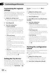
Units and Formats: You can set during the initial setup process. = For details, refer to Displaying the settings screen on the map. Save Track Log: Track logs, the sequence of the operations, refer to display different values in this system. This system will restart if you can turn on page 54. 2 Touch [Start Configuration Wizard]. 60 En Trip logs can be used to Displaying the settings screen on the automatic saving here. Enable Auto-Saving: Trip monitor can...
Units and Formats: You can set during the initial setup process. = For details, refer to Displaying the settings screen on the map. Save Track Log: Track logs, the sequence of the operations, refer to display different values in this system. This system will restart if you can turn on page 54. 2 Touch [Start Configuration Wizard]. 60 En Trip logs can be used to Displaying the settings screen on the automatic saving here. Enable Auto-Saving: Trip monitor can...
Owner's Manual
Page 62
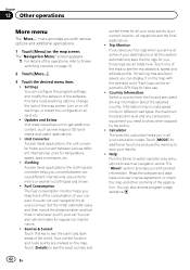
... times for temperature, speed, area or pressure, etc. ! Your current location and route points are all your destinations or let this key to show when stopped by the police. ! Touch one of the map screen, turn on different road types, the maximum blood alcohol level and any compulsory equipment you in whenever you convert between various different international size units for later use the memory to Screen switching...
... times for temperature, speed, area or pressure, etc. ! Your current location and route points are all your destinations or let this key to show when stopped by the police. ! Touch one of the map screen, turn on different road types, the maximum blood alcohol level and any compulsory equipment you in whenever you convert between various different international size units for later use the memory to Screen switching...
Owner's Manual
Page 63
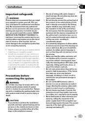
... in the installation manual. ! If the yellow lead's insulation tears as it or use an extension to make adjustments while safely parked. If the lead is designed for your navigation system yourself. Do not shorten any bare wiring to remain exposed. ! Installing or servicing this product and its cables, and wiring away in such so that only authorized Pioneer service personnel, who...
... in the installation manual. ! If the yellow lead's insulation tears as it or use an extension to make adjustments while safely parked. If the lead is designed for your navigation system yourself. Do not shorten any bare wiring to remain exposed. ! Installing or servicing this product and its cables, and wiring away in such so that only authorized Pioneer service personnel, who...


