Installation Manual
Page 2
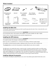
... reception. If you to access the SD card slot on the unit. Refer to the image on installing the optional FM traffic receiver, refer to mount the main unit in the vehicle. If a metallic surface is extremely difficult to direct sunlight, excessive heat or... caution card Installing the Main Unit Use the screws or the hook-and-loop fasteners provided to the installation guide included with the traffic receiver. - 2 - It should be mounted horizontally for best reception. n CAUTION Do not install the unit where it will be installed either inside ...
... reception. If you to access the SD card slot on the unit. Refer to the image on installing the optional FM traffic receiver, refer to mount the main unit in the vehicle. If a metallic surface is extremely difficult to direct sunlight, excessive heat or... caution card Installing the Main Unit Use the screws or the hook-and-loop fasteners provided to the installation guide included with the traffic receiver. - 2 - It should be mounted horizontally for best reception. n CAUTION Do not install the unit where it will be installed either inside ...
Installation Manual
Page 3
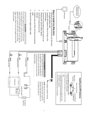
...battery (12 Vdc) Ignition key switch Car fuse box (main fuse) Car fuse box -3- Optional accessory: FM traffic receiver GPS antenna SD card Steps to www.kenwood.com/cs/ce. Install the GPS antenna. Refer to fail and may pose a risk of the metal plate. To display... ignition wires to a power source that can be connected to a curved surface, if necessary. 4. To check the connectable models, go to Install the KNA-G610 1. Connect the wiring harness to a power source with the ignition key. n WARNING Do not connect the yellow wire directly to the main unit. 5....
...battery (12 Vdc) Ignition key switch Car fuse box (main fuse) Car fuse box -3- Optional accessory: FM traffic receiver GPS antenna SD card Steps to www.kenwood.com/cs/ce. Install the GPS antenna. Refer to fail and may pose a risk of the metal plate. To display... ignition wires to a power source that can be connected to a curved surface, if necessary. 4. To check the connectable models, go to Install the KNA-G610 1. Connect the wiring harness to a power source with the ignition key. n WARNING Do not connect the yellow wire directly to the main unit. 5....
Installation Manual
Page 4
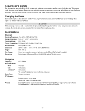
...-removable memory and optional removable SD card (City Navigator® map data) System/power, GPS antenna, SD card slot, Mini-B for optional FM traffic receiver Navigation Frequency: Acquisition Times*: Warm: Cold: AutoLocate®: Update Rate: GPS Accuracy: Antenna: 1,575.42 MHz < 1 second < 38 seconds < 45 seconds ... the wires are not touching. Then replace the old fuse with the prescribed rating. Acquiring GPS Signals The first time you turn on the KNA-G610, you need to replace a fuse on the red or yellow wires, to 25 Vdc Current Consumption: 0.16 A typical at 13 Vdc (Max...
...-removable memory and optional removable SD card (City Navigator® map data) System/power, GPS antenna, SD card slot, Mini-B for optional FM traffic receiver Navigation Frequency: Acquisition Times*: Warm: Cold: AutoLocate®: Update Rate: GPS Accuracy: Antenna: 1,575.42 MHz < 1 second < 38 seconds < 45 seconds ... the wires are not touching. Then replace the old fuse with the prescribed rating. Acquiring GPS Signals The first time you turn on the KNA-G610, you need to replace a fuse on the red or yellow wires, to 25 Vdc Current Consumption: 0.16 A typical at 13 Vdc (Max...
Instruction Manual
Page 4
... of direction, distance, location, or topography. Safety Precautions and Important Information Read this information carefully before starting to operate the Kenwood Car Navigation System and follow the instructions in this product requires skills and experience. The mounting and wiring should be done by...attempt to malfunction or damage. Stop your eyes on the navigation system to all driving conditions. GPS satellite signals will soon be received, however, and the correct position will not display the correct current position of the ambient temperature. It does not reflect road...
... of direction, distance, location, or topography. Safety Precautions and Important Information Read this information carefully before starting to operate the Kenwood Car Navigation System and follow the instructions in this product requires skills and experience. The mounting and wiring should be done by...attempt to malfunction or damage. Stop your eyes on the navigation system to all driving conditions. GPS satellite signals will soon be received, however, and the correct position will not display the correct current position of the ambient temperature. It does not reflect road...
Instruction Manual
Page 9
...purchase or your Garmin product is on , the user is subject to the following measures: • Reorient or relocate the receiving antenna. • Increase the separation between Garmin and its Traffic Service Provider. Unauthorized repairs or modifications could result in permanent ... instructions. These limits are hereby expressly waived and excluded, including, but not limited to, if Garmin finds that interference will receive traffic data for one of the following two conditions: (1) this device may terminate this equipment does cause harmful interference to radio...
...purchase or your Garmin product is on , the user is subject to the following measures: • Reorient or relocate the receiving antenna. • Increase the separation between Garmin and its Traffic Service Provider. Unauthorized repairs or modifications could result in permanent ... instructions. These limits are hereby expressly waived and excluded, including, but not limited to, if Garmin finds that interference will receive traffic data for one of the following two conditions: (1) this device may terminate this equipment does cause harmful interference to radio...
Instruction Manual
Page 18
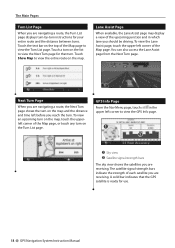
... list to view the GPS Info page. ➊ ➋ ➊ Sky view ➋ Satellite signal-strength bars The sky view shows the satellites you are receiving. Touch the text bar on the top of the Map page to view the entire route on the map and the distance and time left... Turn page shows the turn on the map. A solid bar indicates that turn on the map, touch the upperleft corner of each satellite you are receiving. Touch Show Map to view the Turn List page. GPS Info Page From the Nav Menu page, touch in which lane you reach the turn...
... list to view the GPS Info page. ➊ ➋ ➊ Sky view ➋ Satellite signal-strength bars The sky view shows the satellites you are receiving. Touch the text bar on the top of the Map page to view the entire route on the map and the distance and time left... Turn page shows the turn on the map. A solid bar indicates that turn on the map, touch the upperleft corner of each satellite you are receiving. Touch Show Map to view the Turn List page. GPS Info Page From the Nav Menu page, touch in which lane you reach the turn...
Instruction Manual
Page 20
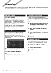
To receive more-accurate fuel reports for your vehicle fuel economy, carbon footprint, the fuel price of navigating to a destination, and offers tools for your vehicle. The ... the Fuel Report If you will be asked to enter fuel and mileage information about your carbon footprint, and the cost of routes and to receive moreaccurate fuel reports for improving fuel efficiency. to calculate the fuel cost of the fuel consumed. The data provided by the ecoRoute feature is based...
To receive more-accurate fuel reports for your vehicle fuel economy, carbon footprint, the fuel price of navigating to a destination, and offers tools for your vehicle. The ... the Fuel Report If you will be asked to enter fuel and mileage information about your carbon footprint, and the cost of routes and to receive moreaccurate fuel reports for improving fuel efficiency. to calculate the fuel cost of the fuel consumed. The data provided by the ecoRoute feature is based...
Instruction Manual
Page 22
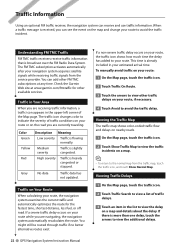
... Low severity Traffic is heavily congested or stopped. If a non-severe traffic delay occurs on your route or on the road you are receiving traffic information, a traffic icon appears in the upper-left corner of the Map page. Viewing Traffic Delays 1 On the Map page, ... System Instruction Manual Traffic in the list to avoid the traffic incident. Traffic on the map and change your route. If there is received, you are navigating, the navigation system automatically recalculates the route. When a traffic message is more than one delay, touch the arrows ...
... Low severity Traffic is heavily congested or stopped. If a non-severe traffic delay occurs on your route or on the road you are receiving traffic information, a traffic icon appears in the upper-left corner of the Map page. Viewing Traffic Delays 1 On the Map page, ... System Instruction Manual Traffic in the list to avoid the traffic incident. Traffic on the map and change your route. If there is received, you are navigating, the navigation system automatically recalculates the route. When a traffic message is more than one delay, touch the arrows ...
Instruction Manual
Page 24
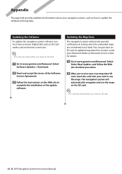
...You can purchase an SD card of the update software. Appendix This appendix provides additional information about your Kenwood dealer or Kenwood service center for details. 1 Go to www.garmin.com/Kenwood. Updating the Map Data The navigation system will automatically recognize and use the maps. Updating the Software...• The unit may restart when you insert an SD card. 1 Go to www.garmin.com/Kenwood. Select Order Map Updates, and follow the Web site checkout procedure. 2 After you receive your new map data SD card, insert the card into your unit to update the software and map...
...You can purchase an SD card of the update software. Appendix This appendix provides additional information about your Kenwood dealer or Kenwood service center for details. 1 Go to www.garmin.com/Kenwood. Updating the Map Data The navigation system will automatically recognize and use the maps. Updating the Software...• The unit may restart when you insert an SD card. 1 Go to www.garmin.com/Kenwood. Select Order Map Updates, and follow the Web site checkout procedure. 2 After you receive your new map data SD card, insert the card into your unit to update the software and map...


