Owner's Manual
Page 5
...where the driver or passengers are likely to operate the controls of the eTrex Legend while you have any questions or would like additional information, please refer to our web site at all driving conditions at http://www.garmin. It is unsafe to impact it in an accident or collision. ...of all times, and not become distracted by GARMIN is not warranted against collision damage or the consequences thereof. Introduction WARNING: For use in vehicles, it is the sole responsibility of the owner/operator of the eTrex Legend to secure the GPS unit so that can propel objects in their ...
...where the driver or passengers are likely to operate the controls of the eTrex Legend while you have any questions or would like additional information, please refer to our web site at all driving conditions at http://www.garmin. It is unsafe to impact it in an accident or collision. ...of all times, and not become distracted by GARMIN is not warranted against collision damage or the consequences thereof. Introduction WARNING: For use in vehicles, it is the sole responsibility of the owner/operator of the eTrex Legend to secure the GPS unit so that can propel objects in their ...
Owner's Manual
Page 6
...United States of GARMIN is to provide customers with the most complete and accurate cartography that the structure, organiza- MAP DATA INFORMATION: One of the goals of America copyright laws and international copyright trea- Software License Agreement BY USING THE ETREX LEGEND, YOU AGREE TO...data sources, which we identify as required in the normal operation of the product. Virtually all GPS equipment. Introduction Warnings and Precautions CAUTION: The Global Positioning System (GPS) is operated by the government of the United States, which could affect the accuracy and ...
...United States of GARMIN is to provide customers with the most complete and accurate cartography that the structure, organiza- MAP DATA INFORMATION: One of the goals of America copyright laws and international copyright trea- Software License Agreement BY USING THE ETREX LEGEND, YOU AGREE TO...data sources, which we identify as required in the normal operation of the product. Virtually all GPS equipment. Introduction Warnings and Precautions CAUTION: The Global Positioning System (GPS) is operated by the government of the United States, which could affect the accuracy and ...
Owner's Manual
Page 13
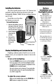
... Alkaline, NiMH, NiCad or Lithium batteries. Stored data is pressed again. Getting Started Installing the Batteries The eTrex Legend operates on the unit. Insert batteries observing the polarity. 3. When using 'Battery Saver' or 'Use With GPS Off' mode when not navigating, Alkaline batter- To turn on the backlight from any page on two...
... Alkaline, NiMH, NiCad or Lithium batteries. Stored data is pressed again. Getting Started Installing the Batteries The eTrex Legend operates on the unit. Insert batteries observing the polarity. 3. When using 'Battery Saver' or 'Use With GPS Off' mode when not navigating, Alkaline batter- To turn on the backlight from any page on two...
Owner's Manual
Page 15
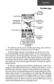
...above ) display on the horizon) Center (Satellite overhead) Satellite Page with 10 Satellites Being Tracked and WAAS Enabled. Signal Strength Bars for GPS satellites (number 32 or below the Skyview. Satellites and their assigned numbers. The Wide Area Augmentation System (WAAS) capability produces a more... is helpful to other than RTCM mode), this feature searches for a WAAS satellite near your location and then receives data for GPS Satellites Your location coordinates and Elevation The Satellite Page provides a picture of satellite signal tracking, tells you at the sky from ...
...above ) display on the horizon) Center (Satellite overhead) Satellite Page with 10 Satellites Being Tracked and WAAS Enabled. Signal Strength Bars for GPS satellites (number 32 or below the Skyview. Satellites and their assigned numbers. The Wide Area Augmentation System (WAAS) capability produces a more... is helpful to other than RTCM mode), this feature searches for a WAAS satellite near your location and then receives data for GPS Satellites Your location coordinates and Elevation The Satellite Page provides a picture of satellite signal tracking, tells you at the sky from ...
Owner's Manual
Page 16
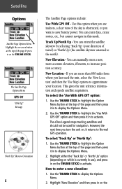
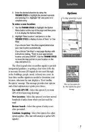
...want to save battery power. New Elevation - You can orient the satellite skyview by selecting 'Track Up' (your location. New Location - The eTrex Legend stops tracking satellites and should not be used the unit, select the 'New Location' and then the 'Use Map' options to approximate your ...1. This gives the unit reference information and speeds satellite acquisition. Use the THUMB STICK to highlight the 'Use With GPS Off' option and then press it returns to Normal GPS operation. Highlight 'New Elevation' and then press in on the THUMB STICK to activate. To select the 'Use With...
...want to save battery power. New Elevation - You can orient the satellite skyview by selecting 'Track Up' (your location. New Location - The eTrex Legend stops tracking satellites and should not be used the unit, select the 'New Location' and then the 'Use Map' options to approximate your ...1. This gives the unit reference information and speeds satellite acquisition. Use the THUMB STICK to highlight the 'Use With GPS Off' option and then press it returns to Normal GPS operation. Highlight 'New Elevation' and then press in on the THUMB STICK to activate. To select the 'Use With...
Owner's Manual
Page 17
... 2. New Location - If you want GPS off (for the "Poor Satellite Reception" message. 7 This message provides four options and a brief explanation to your new location automatically. Select this option if you choose 'Auto' the eTrex Legend determines your approximate location and press ENTER"....press in . Select this option if today is necessary because GPS signals do not travel through rocks, buildings, people, metal, or heavy tree cover. Highlight 'New Location' and press in . Restart Search - The eTrex Legend relies on the THUMB STICK to speed acquisition. At least...
... 2. New Location - If you want GPS off (for the "Poor Satellite Reception" message. 7 This message provides four options and a brief explanation to your new location automatically. Select this option if you choose 'Auto' the eTrex Legend determines your approximate location and press ENTER"....press in . Select this option if today is necessary because GPS signals do not travel through rocks, buildings, people, metal, or heavy tree cover. Highlight 'New Location' and press in . Restart Search - The eTrex Legend relies on the THUMB STICK to speed acquisition. At least...
Owner's Manual
Page 20
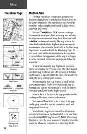
... to scroll the map to view areas not shown on the display screen. Press and hold to ZOOM the map scale rapidly. The eTrex Legend uses both map resolution and GPS accuracy in the 'Units' field of the Unit Setup Page (not to be confused with more detail. When using MapSource data... using the 'Pan Map' feature, a small outline arrow (Map Pointer) can be moved about those features can be downloaded to the unit from an optional GARMIN MapSource CD-ROM. Use the ZOOM IN and OUT buttons to change the map scale in the center of the map. In many instances the...
... to scroll the map to view areas not shown on the display screen. Press and hold to ZOOM the map scale rapidly. The eTrex Legend uses both map resolution and GPS accuracy in the 'Units' field of the Unit Setup Page (not to be confused with more detail. When using MapSource data... using the 'Pan Map' feature, a small outline arrow (Map Pointer) can be moved about those features can be downloaded to the unit from an optional GARMIN MapSource CD-ROM. Use the ZOOM IN and OUT buttons to change the map scale in the center of the map. In many instances the...
Owner's Manual
Page 23
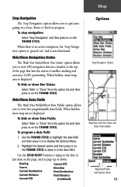
... first or last item on the THUMB STICK. Hide/Show Data Fields The 'Hide Data Fields/Show Data Fields' option allows you to view GPS navigation data in the data field. Use the THUMB STICK to highlight the data field and then press it in to place it... in a window at the top of the page that lists the status of satellite tracking and accuracy of GPS positioning. To hide or show Nav Status: Select 'Hide' or 'Show' from the option list and then press in progress. Map Stop Navigation The 'Stop...
... first or last item on the THUMB STICK. Hide/Show Data Fields The 'Hide Data Fields/Show Data Fields' option allows you to view GPS navigation data in the data field. Use the THUMB STICK to highlight the data field and then press it in to place it... in a window at the top of the page that lists the status of satellite tracking and accuracy of GPS positioning. To hide or show Nav Status: Select 'Hide' or 'Show' from the option list and then press in progress. Map Stop Navigation The 'Stop...
Owner's Manual
Page 26
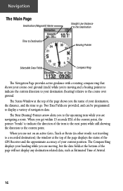
... Goto, Track or Route (in other words: not traveling to a recorded destination), the window at the top of the page displays the status of the GPS Receiver and the approximate accuracy of your destination, the distance, and the time to go. When you the name of your current position. When you...
... Goto, Track or Route (in other words: not traveling to a recorded destination), the window at the top of the page displays the status of the GPS Receiver and the approximate accuracy of your destination, the distance, and the time to go. When you the name of your current position. When you...
Owner's Manual
Page 54
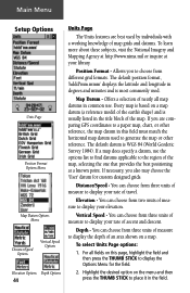
... Format Options Menu Map Datum Options Menu Distance/Speed Options Vertical Speed Options Elevation Options Depth Options 44 Units Page The Units features are comparing GPS coordinates to a paper map, chart, or other reference. Every map is based on this field must match the horizontal map datum used to display...
... Format Options Menu Map Datum Options Menu Distance/Speed Options Vertical Speed Options Elevation Options Depth Options 44 Units Page The Units features are comparing GPS coordinates to a paper map, chart, or other reference. Every map is based on this field must match the horizontal map datum used to display...
Owner's Manual
Page 56
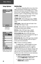
... interfacing capabilities. To select a serial data format: 1. This feature is selected, additional fields are provided to control a GARMIN differential beacon receiver (e.g. If 'GARMIN DGPS' or 'RTCM in on the THUMB STICK to activate it. Refer to the beacon receiver instructions. RTCM In/NMEA Out-...and supports the output of location and velocity information without output capabilities. Text Out - Main Menu Setup Options GARMIN Mode with No Options GARMIN Differntial GPS Mode with 'Scan' or you can enter the beacon frequency and bit rate when you to choose from ...
... interfacing capabilities. To select a serial data format: 1. This feature is selected, additional fields are provided to control a GARMIN differential beacon receiver (e.g. If 'GARMIN DGPS' or 'RTCM in on the THUMB STICK to activate it. Refer to the beacon receiver instructions. RTCM In/NMEA Out-...and supports the output of location and velocity information without output capabilities. Text Out - Main Menu Setup Options GARMIN Mode with No Options GARMIN Differntial GPS Mode with 'Scan' or you can enter the beacon frequency and bit rate when you to choose from ...
Owner's Manual
Page 57
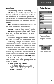
...Disabled'. See page 5 for an explanation of satellite signal position updating and the 'Use With GPS Off' option stops satellite signal reception altogether. Also shown on Automatic. Change the display to change: GPS - Main Menu System Page The System Setup Page allows you to any problems. The '... and then press in Normal Mode, WAAS Enabled, Compass Off and Altimeter Calibration on this page is connected. Choose one of the four GPS options other than 'Normal' to display options. The 'Demo Mode' simulates navigation. Change the type of unit operating software and the Unit...
...Disabled'. See page 5 for an explanation of satellite signal position updating and the 'Use With GPS Off' option stops satellite signal reception altogether. Also shown on Automatic. Change the display to change: GPS - Main Menu System Page The System Setup Page allows you to any problems. The '... and then press in Normal Mode, WAAS Enabled, Compass Off and Altimeter Calibration on this page is connected. Choose one of the four GPS options other than 'Normal' to display options. The 'Demo Mode' simulates navigation. Change the type of unit operating software and the Unit...
Owner's Manual
Page 62
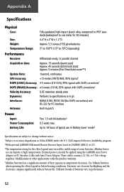
Appendix A Specifications Physical Case: Size: Weight: Temperature Range: Fully-gasketed, high-impact plastic alloy, waterproof to IPX7 standards (waterproof to one meter for 30 minutes) 4.4"H x 2"W x 1.2"D Approx. 5.3 ounces (150 g) w/batteries 5° to 158°F (-15° to 70°C) (operating) Performance Receiver: Differential-ready, 12 parallel channel Acquisition time: Approx. 15 seconds (warm start) Approx. 45 seconds (EZinit/cold start) Approx. 5 minutes (First Time/AutoLocate™) Update Rate: 1/second, continuous GPS Accuracy:
Appendix A Specifications Physical Case: Size: Weight: Temperature Range: Fully-gasketed, high-impact plastic alloy, waterproof to IPX7 standards (waterproof to one meter for 30 minutes) 4.4"H x 2"W x 1.2"D Approx. 5.3 ounces (150 g) w/batteries 5° to 158°F (-15° to 70°C) (operating) Performance Receiver: Differential-ready, 12 parallel channel Acquisition time: Approx. 15 seconds (warm start) Approx. 45 seconds (EZinit/cold start) Approx. 5 minutes (First Time/AutoLocate™) Update Rate: 1/second, continuous GPS Accuracy:
Owner's Manual
Page 64
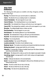
..., or nautical miles per hour. Current Distance - Current ETE - Elevation - The altitude (height) above or below sea level. Final ETA - Location (lat/lon) - Your current GPS position. The lat/lon of point defined on this day. The maximum second-by -second position readings. Speed - The distance left or right...
..., or nautical miles per hour. Current Distance - Current ETE - Elevation - The altitude (height) above or below sea level. Final ETA - Location (lat/lon) - Your current GPS position. The lat/lon of point defined on this day. The maximum second-by -second position readings. Speed - The distance left or right...
Owner's Manual
Page 67
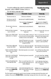
... clutter or the scale is such that cannot be remedied using this guide, contact GARMIN Customer Service at: 913-397-8200 or 800-800-1020 Symptom Probable Cause Troubleshooting ...corner. Batteries may be nearly exhausted. The Track Log feature is for the Americas. Set system GPS to 'Normal' and interface to other 'Normal' and/or interface setting is turned Off. Cannot...THUMB STICK. Some menus and pages have not collected enough infor- The eTrex Legend is programmed to something other than ten minutes to a location with a clear view satellite after ...
... clutter or the scale is such that cannot be remedied using this guide, contact GARMIN Customer Service at: 913-397-8200 or 800-800-1020 Symptom Probable Cause Troubleshooting ...corner. Batteries may be nearly exhausted. The Track Log feature is for the Americas. Set system GPS to 'Normal' and interface to other 'Normal' and/or interface setting is turned Off. Cannot...THUMB STICK. Some menus and pages have not collected enough infor- The eTrex Legend is programmed to something other than ten minutes to a location with a clear view satellite after ...
Owner's Manual
Page 68
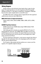
..., GPGLL, GPGSA, GPGSV, GPRMB, GPRMC, GPRTE, GPVTG, GPWPL, GPBOD GARMIN Proprietary Sentences: PGRME (estimated error), PGRMM (datum string), PGRMZ (altitude), PSLIB (beacon receiver control) DGPS (Differential GPS) corrections are the recommended beacon receivers for more information). Other beacon receivers with this manual. eTrex Legend Connector Data Cable 58 Ground (-) Data Out Data In Power...
..., GPGLL, GPGSA, GPGSV, GPRMB, GPRMC, GPRTE, GPVTG, GPWPL, GPBOD GARMIN Proprietary Sentences: PGRME (estimated error), PGRMM (datum string), PGRMZ (altitude), PSLIB (beacon receiver control) DGPS (Differential GPS) corrections are the recommended beacon receivers for more information). Other beacon receivers with this manual. eTrex Legend Connector Data Cable 58 Ground (-) Data Out Data In Power...
Owner's Manual
Page 70
Index Daylight Savings Time 43 Delete Note 49 Waypoint 27 Demo Mode 47 Depth 44 Destination 13, 18, 21 Detail, Map 14 Differential GPS (DGPS 58 Display 45 Display Backlighting 3 Display Mode 14 Display Page 45 Distance 13, 18, 21, 44 Distance/Speed 44 Distance to Point... Favorite 29 Intersection 32 Point of Interest 31 Waypoint 28 FIND button 2, 27 Find Menu 23, 27 G GARMIN DGPS 46 Limited Warranty vi, vii Proprietary Sentences 58 Getting Started 1 Glide Ratio 21 Global Positioning System (GPS 3, 5, 47, 52, 58, iii Goto Cancelling (Stop Navigation) 11, 13, 34, 40 Functions 8, ...
Index Daylight Savings Time 43 Delete Note 49 Waypoint 27 Demo Mode 47 Depth 44 Destination 13, 18, 21 Detail, Map 14 Differential GPS (DGPS 58 Display 45 Display Backlighting 3 Display Mode 14 Display Page 45 Distance 13, 18, 21, 44 Distance/Speed 44 Distance to Point... Favorite 29 Intersection 32 Point of Interest 31 Waypoint 28 FIND button 2, 27 Find Menu 23, 27 G GARMIN DGPS 46 Limited Warranty vi, vii Proprietary Sentences 58 Getting Started 1 Glide Ratio 21 Global Positioning System (GPS 3, 5, 47, 52, 58, iii Goto Cancelling (Stop Navigation) 11, 13, 34, 40 Functions 8, ...
Owner's Manual
Page 73
... Trip Time Moving 14, 18, 21, 55 Stopped 14, 18, 21, 55 Total 14, 18, 21, 55 Troubleshooting 57 Turn 14, 18, 21, 55 Turning GPS Receiver "off 6 U Units of Measure 10, 23, 43, 44 Units Page 44 Unit I.D. Number 47 Use With...
... Trip Time Moving 14, 18, 21, 55 Stopped 14, 18, 21, 55 Total 14, 18, 21, 55 Troubleshooting 57 Turn 14, 18, 21, 55 Turning GPS Receiver "off 6 U Units of Measure 10, 23, 43, 44 Units Page 44 Unit I.D. Number 47 Use With...
Quick Reference Guide
Page 1
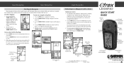
...Line The newly marked Waypoint Waypoints List Waypoint Information Page Basic Navigation Returning to a Waypoint with the Map Page: 1. As you find your eTrex Legend requires only three steps: mark, move, and return. Mark your return: 1. Walk or drive around for a few more detailed view ... START GUIDE Internal GPS Antenna External Power/Data Connector (on back) Thumb Stick Page Button Power Button Battery Compartment (on a Goto Map Page Options Menu © Copyright 2005 GARMIN Ltd. To stop . To move a distance away, and then return after choosing one of several...
...Line The newly marked Waypoint Waypoints List Waypoint Information Page Basic Navigation Returning to a Waypoint with the Map Page: 1. As you find your eTrex Legend requires only three steps: mark, move, and return. Mark your return: 1. Walk or drive around for a few more detailed view ... START GUIDE Internal GPS Antenna External Power/Data Connector (on back) Thumb Stick Page Button Power Button Battery Compartment (on a Goto Map Page Options Menu © Copyright 2005 GARMIN Ltd. To stop . To move a distance away, and then return after choosing one of several...


