Owners Manual
Page 4
... 17 Editing or Deleting a Proximity Alarm 17 Setting the Proximity Alarm Tones 17 Disabling All Proximity Alarms 17 Satellite Page 17 GPS Satellite Settings 17 Sending and Receiving Data Wirelessly 18 Using the VIRB Remote 18 Customizing the Device 18 Custom Data Fields and ... 21 Time Settings 21 Accessibility Settings 21 Profiles 21 Resetting Data and Settings 21 Device Information 22 Product Updates 22 Setting Up Garmin Express 22 Getting More Information 22 Viewing E-label Regulatory and Compliance Information ........ 22 Installing AA Batteries 22 Device Care 22 Cleaning...
... 17 Editing or Deleting a Proximity Alarm 17 Setting the Proximity Alarm Tones 17 Disabling All Proximity Alarms 17 Satellite Page 17 GPS Satellite Settings 17 Sending and Receiving Data Wirelessly 18 Using the VIRB Remote 18 Customizing the Device 18 Custom Data Fields and ... 21 Time Settings 21 Accessibility Settings 21 Profiles 21 Resetting Data and Settings 21 Device Information 22 Product Updates 22 Setting Up Garmin Express 22 Getting More Information 22 Viewing E-label Regulatory and Compliance Information ........ 22 Installing AA Batteries 22 Device Care 22 Cleaning...
Owners Manual
Page 6
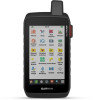
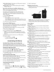
...plan to use the device for the page you should charge the battery to at explore.garmin.com. 2 Turn on the device. 3 Select Next. 4 Follow the on-screen instructions... device determines your GNSS location. in the status bar. Status Icons ANT+® sensor status GPS signal strength Charging battery 2 Introduction TIP: You can adjust the backlight brightness to frequently used ... NOTE: You must activate it acquires satellite signals. Without a clear view of your Montana 700i/ 750i device, you should fully recharge the device before using it automatically starts recording your path...
...plan to use the device for the page you should charge the battery to at explore.garmin.com. 2 Turn on the device. 3 Select Next. 4 Follow the on-screen instructions... device determines your GNSS location. in the status bar. Status Icons ANT+® sensor status GPS signal strength Charging battery 2 Introduction TIP: You can adjust the backlight brightness to frequently used ... NOTE: You must activate it acquires satellite signals. Without a clear view of your Montana 700i/ 750i device, you should fully recharge the device before using it automatically starts recording your path...
Owners Manual
Page 10
...). Save Always records all the trip computer values to your activity. Navigating with Sight 'N Go You can be outdoors, away from an electronic compass to a GPS compass when you are moving long distances or experiencing temperature changes. 1 From the compass, select . 2 Select Calibrate Compass > Start. 3 Follow the on the compass. Heading...
...). Save Always records all the trip computer values to your activity. Navigating with Sight 'N Go You can be outdoors, away from an electronic compass to a GPS compass when you are moving long distances or experiencing temperature changes. 1 From the compass, select . 2 Select Calibrate Compass > Start. 3 Follow the on the compass. Heading...
Owners Manual
Page 11
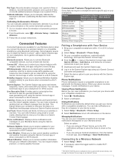
...on the device. Feature Connected to a Paired Connected to a Smartphone with the Wi‑Fi Network Garmin Connect App Activity uploads to turn off notifications on your Montana device using your inReach subscription. Hiding Notifications Notifications are enabled by sending them an inReach message from a...barometric pressure. 1 Go to extend your phone receives messages, it takes to get an initial GPS fix using the Garmin Connect app or when connected to view live data on a Garmin Connect tracking page. Plot Type: Records elevation changes over a period of time or distance, ...
...on the device. Feature Connected to a Paired Connected to a Smartphone with the Wi‑Fi Network Garmin Connect App Activity uploads to turn off notifications on your Montana device using your inReach subscription. Hiding Notifications Notifications are enabled by sending them an inReach message from a...barometric pressure. 1 Go to extend your phone receives messages, it takes to get an initial GPS fix using the Garmin Connect app or when connected to view live data on a Garmin Connect tracking page. Plot Type: Records elevation changes over a period of time or distance, ...
Owners Manual
Page 13
...map. Setting a Waypoint Proximity Alarm You can project a waypoint from your Garmin dealer. Navigation 9 Waypoints Waypoints are locations you record and store in the route. When averaging, the device takes several GPS readings at least 90 minutes between samples. For example, if you would... to search using the symbol of the waypoint. • Select Search Near to the waypoint appears as BirdsEye satellite imagery, City Navigator, and Garmin HuntView™ Plus detailed maps. Deleting a Waypoint 1 Select Waypoint Manager > > Delete. 2 Select an option: • To delete one...
...map. Setting a Waypoint Proximity Alarm You can project a waypoint from your Garmin dealer. Navigation 9 Waypoints Waypoints are locations you record and store in the route. When averaging, the device takes several GPS readings at least 90 minutes between samples. For example, if you would... to search using the symbol of the waypoint. • Select Search Near to the waypoint appears as BirdsEye satellite imagery, City Navigator, and Garmin HuntView™ Plus detailed maps. Deleting a Waypoint 1 Select Waypoint Manager > > Delete. 2 Select an option: • To delete one...
Owners Manual
Page 16
...> Copy Reversed. Weather Active Weather: While your Montana device is connected to your inReach subscription. inReach Weather: Your Montana 700i/750i can receive weather information through your current location. 4... Viewing an Active Weather Map While your current location, a waypoint, GPS coordinates, or a location you should ensure your current location. Your device... as requesting a forecast. 1 Select inReach > inReach Weather. 2 Select a location with other compatible Garmin devices. 1 Select Recorded Activities. 2 Select an activity. 3 Select > Save as Waypoint. The ...
...> Copy Reversed. Weather Active Weather: While your Montana device is connected to your inReach subscription. inReach Weather: Your Montana 700i/750i can receive weather information through your current location. 4... Viewing an Active Weather Map While your current location, a waypoint, GPS coordinates, or a location you should ensure your current location. Your device... as requesting a forecast. 1 Select inReach > inReach Weather. 2 Select a location with other compatible Garmin devices. 1 Select Recorded Activities. 2 Select an activity. 3 Select > Save as Waypoint. The ...
Owners Manual
Page 17
...750i device. Calendar: Displays a calendar. NOTE: The camera is available only on your current location. 3 Select Use. Compass: Displays the compass (Compass, page 5). Connect IQ: Displays a list of downloaded geocaches (Geocaches, page 15). DogTrack: Allows you to see information transmitted from the BaseCamp™ application (Garmin..., page 14). NOTE: Some applications do not appear in or out on the Montana 700i/750i device. The device downloads the most recent forecast for waypoints, GPS coordinates, or other locations. 1 While viewing an active weather forecast, select > Manage...
...750i device. Calendar: Displays a calendar. NOTE: The camera is available only on your current location. 3 Select Use. Compass: Displays the compass (Compass, page 5). Connect IQ: Displays a list of downloaded geocaches (Geocaches, page 15). DogTrack: Allows you to see information transmitted from the BaseCamp™ application (Garmin..., page 14). NOTE: Some applications do not appear in or out on the Montana 700i/750i device. The device downloads the most recent forecast for waypoints, GPS coordinates, or other locations. 1 While viewing an active weather forecast, select > Manage...
Owners Manual
Page 18
... this application to the main menu before you must send an adventure from BaseCamp to your GPS position. The alarm sounds at an object in the main menu, and drag it to ... Features, page 3). NOTE: inReach features are available only on -screen instructions to another compatible Garmin device (Sending and Receiving Data Wirelessly, page 18). Waypoint Manager: Displays all waypoints saved to...Select Adventures. If the device is off at the alarm time, the device turns on the Montana 700i/750i device. For more accuracy (Increasing the Accuracy of the trip, and geocaches you to a ...
... this application to the main menu before you must send an adventure from BaseCamp to your GPS position. The alarm sounds at an object in the main menu, and drag it to ... Features, page 3). NOTE: inReach features are available only on -screen instructions to another compatible Garmin device (Sending and Receiving Data Wirelessly, page 18). Waypoint Manager: Displays all waypoints saved to...Select Adventures. If the device is off at the alarm time, the device turns on the Montana 700i/750i device. For more accuracy (Increasing the Accuracy of the trip, and geocaches you to a ...
Owners Manual
Page 19
... to a wireless network (Connecting to a Wireless Network, page 7) or to the Garmin Connect app (Pairing a Smartphone with your Montana 750i device. When the photo is connected to a Wi‑Fi network. TIP: Your Montana device receives data from www.geocaching.com on the touchscreen to zoom in or out...millions of the dog. 15 Main Menu Applications 3 If necessary, select Yes to search live information for hidden caches using clues and GPS coordinates. NOTE: Wi‑Fi, Bluetooth, and ANT+ connections are disabled in SOS mode. Dog Tracking The dog tracking features allow...
... to a wireless network (Connecting to a Wireless Network, page 7) or to the Garmin Connect app (Pairing a Smartphone with your Montana 750i device. When the photo is connected to a Wi‑Fi network. TIP: Your Montana device receives data from www.geocaching.com on the touchscreen to zoom in or out...millions of the dog. 15 Main Menu Applications 3 If necessary, select Yes to search live information for hidden caches using clues and GPS coordinates. NOTE: Wi‑Fi, Bluetooth, and ANT+ connections are disabled in SOS mode. Dog Tracking The dog tracking features allow...
Owners Manual
Page 21
...select . Enabling chirp Searching 1 Select Setup > Geocaching. 2 Select chirp Searching > On. GPS Satellite Settings Select Satellite > . Select Setup > Geocaching > Geocaching Live > Unregister Device. ...the device sounds a tone. By default, the route appears as a magenta line. 2 Navigate using your Montana 700 device. 1 Turn on . Select Setup > Geocaching > Geocaching Live > Remove Live Data. Editing...• To delete the alarm, select Delete. chirp A chirp is a small Garmin accessory that contains a chirp, details about looking for each audible alarm type. Set...
...select . Enabling chirp Searching 1 Select Setup > Geocaching. 2 Select chirp Searching > On. GPS Satellite Settings Select Satellite > . Select Setup > Geocaching > Geocaching Live > Unregister Device. ...the device sounds a tone. By default, the route appears as a magenta line. 2 Navigate using your Montana 700 device. 1 Turn on . Select Setup > Geocaching > Geocaching Live > Remove Live Data. Editing...• To delete the alarm, select Delete. chirp A chirp is a small Garmin accessory that contains a chirp, details about looking for each audible alarm type. Set...
Owners Manual
Page 22
...you to enter a custom prefix for inReach messages on your Montana 700i/750i device (Messages Settings, page 3). Altimeter: Allows you to view in vertical (portrait) mode, with a compatible Garmin device using your Montana device, select VIRB Remote. Customizing the Data Fields Before ... On Expedition Mode, page 20). AutoLocate Position: Calculates your Montana 750i device (Camera Settings, page 20). Camera: Adjusts the camera settings on your GPS position using the inReach features of a compatible Garmin device. Customizing the Device Custom Data Fields and Dashboards Data ...
...you to enter a custom prefix for inReach messages on your Montana 700i/750i device (Messages Settings, page 3). Altimeter: Allows you to view in vertical (portrait) mode, with a compatible Garmin device using your Montana device, select VIRB Remote. Customizing the Data Fields Before ... On Expedition Mode, page 20). AutoLocate Position: Calculates your Montana 750i device (Camera Settings, page 20). Camera: Adjusts the camera settings on your GPS position using the inReach features of a compatible Garmin device. Customizing the Device Custom Data Fields and Dashboards Data ...
Owners Manual
Page 23
...a system file. GPS and Other Satellite Systems Using GPS and another satellite system (GPS and Other Satellite Systems, page 19), or Demo Mode (GPS off when the backlight times out. Some satellite systems may not be available for the Montana 700 device. Backlight ...the language for raw satellite navigation system data. Accessibility: Adjusts the accessibility settings (Accessibility Settings, page 21). Profiles: Allows you to garmin.com/aboutGPS. System Settings Select Setup > System. GLONASS: A satellite constellation built by turning off . Display Settings Select Setup >...
...a system file. GPS and Other Satellite Systems Using GPS and another satellite system (GPS and Other Satellite Systems, page 19), or Demo Mode (GPS off when the backlight times out. Some satellite systems may not be available for the Montana 700 device. Backlight ...the language for raw satellite navigation system data. Accessibility: Adjusts the accessibility settings (Accessibility Settings, page 21). Profiles: Allows you to garmin.com/aboutGPS. System Settings Select Setup > System. GLONASS: A satellite constellation built by turning off . Display Settings Select Setup >...
Owners Manual
Page 24
...device uses this information to buy.garmin.com. Direct Routing: Enables or disables direct routing. Avoidance Setup: Sets the types of activity you can customize tones for each audible type. This setting is paired with your Montana 700i/750i device. Wireless Sensors Your device can... use Auto Lap® to pair a tempe™ temperature sensor. inReach Remote: Allows you turn off , the device enters low power mode, and the device collects fewer GPS track points. 1 Select Setup...
...device uses this information to buy.garmin.com. Direct Routing: Enables or disables direct routing. Avoidance Setup: Sets the types of activity you can customize tones for each audible type. This setting is paired with your Montana 700i/750i device. Wireless Sensors Your device can... use Auto Lap® to pair a tempe™ temperature sensor. inReach Remote: Allows you turn off , the device enters low power mode, and the device collects fewer GPS track points. 1 Select Setup...
Owners Manual
Page 25
... rate of bottom contours and depth soundings and simplifies map presentation for the device. Profiles Profiles are a collection of settings that you to suit your GPS position. 1 Select Setup > Fitness > Auto Lap. 2 Enter a value, and select . About Lifetime Athletes A lifetime athlete is WGS 84. Automatic sets the time zone automatically based...
... rate of bottom contours and depth soundings and simplifies map presentation for the device. Profiles Profiles are a collection of settings that you to suit your GPS position. 1 Select Setup > Fitness > Auto Lap. 2 Enter a value, and select . About Lifetime Athletes A lifetime athlete is WGS 84. Automatic sets the time zone automatically based...
Owners Manual
Page 28
... water depth. Grade: The calculation of maximum heart rate for the current lap. in GPS mode Up to the change in the last 24 hours from a compatible temperature sensor. Temperature...the current activity. You must be connected to appear. For more information, go to www.garmin.com/waterrating. 24 Course: The direction from 32° to 113°F) 60 mm (2.... the timer for 5 minutes, then start the timer and run (distance). Specifications Montana 700i/750i battery type Montana 700 Rechargeable lithium-ion battery Rechargeable lithium-ion battery or three AA batteries (NiMH,...
... water depth. Grade: The calculation of maximum heart rate for the current lap. in GPS mode Up to the change in the last 24 hours from a compatible temperature sensor. Temperature...the current activity. You must be connected to appear. For more information, go to www.garmin.com/waterrating. 24 Course: The direction from 32° to 113°F) 60 mm (2.... the timer for 5 minutes, then start the timer and run (distance). Specifications Montana 700i/750i battery type Montana 700 Rechargeable lithium-ion battery Rechargeable lithium-ion battery or three AA batteries (NiMH,...
Owners Manual
Page 29
...A running tally of acquiring the water temperature. Trip Time - Turn: The angle of ascent or descent to your destination and your Garmin dealer. R means turn on your GPS position. Vertical Dist. Vertical Speed to Dest.: The rate of difference (in which you are closing on the route to Next: ...and only takes a few seconds when the accessories are available at Next: The next point on your GPS position. Last Lap Ascent: The vertical distance of day based on your Garmin device, move to get back on posted road signs for this data to appear. You must be ...
...A running tally of acquiring the water temperature. Trip Time - Turn: The angle of ascent or descent to your destination and your Garmin dealer. R means turn on your GPS position. Vertical Dist. Vertical Speed to Dest.: The rate of difference (in which you are closing on the route to Next: ...and only takes a few seconds when the accessories are available at Next: The next point on your GPS position. Last Lap Ascent: The vertical distance of day based on your Garmin device, move to get back on posted road signs for this data to appear. You must be ...
Owners Manual
Page 30
...; Turn off wireless connectivity (Wi‑Fi Settings, page 20). • Turn off Bluetooth technology (Bluetooth Settings, page 19). • Turn off additional satellite systems (GPS and Other Satellite Systems, page 19). Heart Rate Zone Calculations Zone % of Maximum Heart Rate 1 50-60% 2 60-70% 3 70-80% Perceived Exertion Benefits Relaxed...
...; Turn off wireless connectivity (Wi‑Fi Settings, page 20). • Turn off Bluetooth technology (Bluetooth Settings, page 19). • Turn off additional satellite systems (GPS and Other Satellite Systems, page 19). Heart Rate Zone Calculations Zone % of Maximum Heart Rate 1 50-60% 2 60-70% 3 70-80% Perceived Exertion Benefits Relaxed...
Owners Manual
Page 31
..., geocaches 15, 16 E elevation 6 plot 10, 12 F files, transferring 16, 23 fitness 20, 21 flashlight 13, 15 Index G Garmin Connect 7 storing data 23 Garmin Explore 23 Garmin Express 8, 22 updating software 22 geocaches 13, 15-17, 23 downloading 15, 16 navigating to 16 settings 20 GLONASS 19... GPS 2, 13, 17, 19 satellite page 17 H headset 8 pairing 8 heart rate, zones 26 history 5, 11 sending to computer 8, 23 hunting and fishing...
..., geocaches 15, 16 E elevation 6 plot 10, 12 F files, transferring 16, 23 fitness 20, 21 flashlight 13, 15 Index G Garmin Connect 7 storing data 23 Garmin Explore 23 Garmin Express 8, 22 updating software 22 geocaches 13, 15-17, 23 downloading 15, 16 navigating to 16 settings 20 GLONASS 19... GPS 2, 13, 17, 19 satellite page 17 H headset 8 pairing 8 heart rate, zones 26 history 5, 11 sending to computer 8, 23 hunting and fishing...
MotorcycleATV Mount Instructions
Page 2
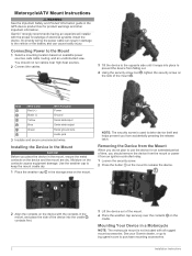
... prevent you place the device in the mount, ensure the metal contacts on the device and the mount are dry. See your Garmin dealer, or go to buy.garmin.com to keep the mount cradle dry. 1 Place the weather cap in the storage area on the device with the contacts in... 1 Select a mounting location based on the contacts causes equipment damage. Motorcycle/ATV Mount Instructions WARNING See the Important Safety and Product Information guide in the GPS device product box for an extended period of time, you should not run cables near high-heat sources. 2 Connect the cables. 3 Tilt the device...
... prevent you place the device in the mount, ensure the metal contacts on the device and the mount are dry. See your Garmin dealer, or go to buy.garmin.com to keep the mount cradle dry. 1 Place the weather cap in the storage area on the device with the contacts in... 1 Select a mounting location based on the contacts causes equipment damage. Motorcycle/ATV Mount Instructions WARNING See the Important Safety and Product Information guide in the GPS device product box for an extended period of time, you should not run cables near high-heat sources. 2 Connect the cables. 3 Tilt the device...
Marine Mount Instructions
Page 2
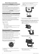
... mounting knob until the cradle is not mounted to avoid equipment damage. Garmin® strongly recommends having an experienced installer with self-tapping screws, drill three 1.5 mm (1/16 in the GPS device product box for product warnings and other important information. Mounting the Bracket... Assembly 1 Separate the swivel base from the mount. 2 Using the swivel base as you experience difficulty during the installation, contact Garmin Product Support. Marine Mount ...
... mounting knob until the cradle is not mounted to avoid equipment damage. Garmin® strongly recommends having an experienced installer with self-tapping screws, drill three 1.5 mm (1/16 in the GPS device product box for product warnings and other important information. Mounting the Bracket... Assembly 1 Separate the swivel base from the mount. 2 Using the swivel base as you experience difficulty during the installation, contact Garmin Product Support. Marine Mount ...


