Owners Manual
Page 3
... a Route on the Map 10 Viewing the Elevation Plot of Contents i Table of Contents Introduction 1 Device Overviews 1 Montana 700i/750i Device Overview 1 Montana 700 Device Overview 1 Status LED 1 Installing the Lithium-ion Battery 1 Charging the Battery Pack 1 Saving Energy While Charging the Device 2 Long-Term Storage 2 Using the Power Button 2 Viewing the Status Page 2 Adjusting the Backlight 2 Using the Touchscreen 2 Locking the Touchscreen 2 Unlocking the Touchscreen 2 Activating the Device 2 Iridium Satellite Network 2 Acquiring Satellite Signals 2 Status Icons...
... a Route on the Map 10 Viewing the Elevation Plot of Contents i Table of Contents Introduction 1 Device Overviews 1 Montana 700i/750i Device Overview 1 Montana 700 Device Overview 1 Status LED 1 Installing the Lithium-ion Battery 1 Charging the Battery Pack 1 Saving Energy While Charging the Device 2 Long-Term Storage 2 Using the Power Button 2 Viewing the Status Page 2 Adjusting the Backlight 2 Using the Touchscreen 2 Locking the Touchscreen 2 Unlocking the Touchscreen 2 Activating the Device 2 Iridium Satellite Network 2 Acquiring Satellite Signals 2 Status Icons...
Owners Manual
Page 4
...20 Marine Settings 21 Menu Settings 21 Position Format Settings 21 Changing the Units of Measure 21 Time Settings 21 Accessibility Settings 21 Profiles 21 Resetting Data and Settings 21 Device Information 22 Product Updates 22 Setting Up Garmin Express 22 Getting More Information 22 Viewing E-label Regulatory and Compliance Information ........ 22 Installing AA Batteries 22 Device Care 22 Cleaning the Device 23 Cleaning the Touchscreen 23 Data Management 23 File Types 23 Installing a Memory Card 23 Connecting the Device to Your Computer 23 Transferring Files to Your Device...
...20 Marine Settings 21 Menu Settings 21 Position Format Settings 21 Changing the Units of Measure 21 Time Settings 21 Accessibility Settings 21 Profiles 21 Resetting Data and Settings 21 Device Information 22 Product Updates 22 Setting Up Garmin Express 22 Getting More Information 22 Viewing E-label Regulatory and Compliance Information ........ 22 Installing AA Batteries 22 Device Care 22 Cleaning the Device 23 Cleaning the Touchscreen 23 Data Management 23 File Types 23 Installing a Memory Card 23 Connecting the Device to Your Computer 23 Transferring Files to Your Device...

Owners Manual
Page 7
...send interval. You can include your Montana 700i/750i device to operate properly. Navigating to use the tracking feature on the Garmin Explore website. • To write a custom message, select Type Message. 3 Select To to a Message 1 Select inReach > Messages. 2 Select a conversation. 3 Select Reply. 4 Select an option: • To write a custom message, select Type Message. • To start with a pre-written message, select Send Quick Text and select a message. 5 When you read a new message. Stopping Tracking Select inReach > Tracking > Stop Tracking. For these features...
...send interval. You can include your Montana 700i/750i device to operate properly. Navigating to use the tracking feature on the Garmin Explore website. • To write a custom message, select Type Message. 3 Select To to a Message 1 Select inReach > Messages. 2 Select a conversation. 3 Select Reply. 4 Select an option: • To write a custom message, select Type Message. • To start with a pre-written message, select Send Quick Text and select a message. 5 When you read a new message. Stopping Tracking Select inReach > Tracking > Stop Tracking. For these features...
Owners Manual
Page 9
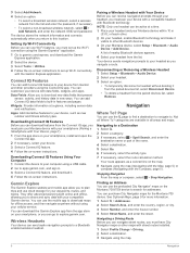
... main menu, map, compass, trip computer, and Where To? Map represents your position on the dashboard. You can view the number of the direction you must zoom in and out of the page. • Select Automotive Mode to open additional map settings (Map Settings, page 5). When you to factory default settings. Map Page Settings From the map, select . Stop Navigation: Stops navigating the current route. Map Setup: Enables you are moving . 1 Begin navigating to a destination (Navigating to a Destination, page 8). 2 Turn until it to a new location to select...
... main menu, map, compass, trip computer, and Where To? Map represents your position on the dashboard. You can view the number of the direction you must zoom in and out of the page. • Select Automotive Mode to open additional map settings (Map Settings, page 5). When you to factory default settings. Map Page Settings From the map, select . Stop Navigation: Stops navigating the current route. Map Setup: Enables you are moving . 1 Begin navigating to a destination (Navigating to a Destination, page 8). 2 Turn until it to a new location to select...
Owners Manual
Page 10
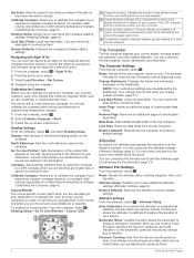
... long distances or after extreme temperature changes (Calibrating the Compass, page 6). Barometer Mode: Variable Elevation allows the barometer to calibrate the compass if you to measure changes in the direction of directional heading shown on -screen instructions. Save Always records all the trip computer values to view details about that appears on water. Navigating with the course line pointer, you are on the course deviation indicator. Lock Data Fields: Locks the data fields. Trip Computer The trip computer displays your destination. You can customize...
... long distances or after extreme temperature changes (Calibrating the Compass, page 6). Barometer Mode: Variable Elevation allows the barometer to calibrate the compass if you to measure changes in the direction of directional heading shown on -screen instructions. Save Always records all the trip computer values to view details about that appears on water. Navigating with the course line pointer, you are on the course deviation indicator. Lock Data Fields: Locks the data fields. Trip Computer The trip computer displays your destination. You can customize...
Owners Manual
Page 11
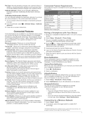
Calibrate Altimeter: Allows you to connect Bluetooth compatible sensors, such as a heart rate monitor. EPO Downloads: Allows you connect the device to your smartphone. Live Geocache Data: Provides paid or subscription-free services to the Garmin Explore app using the Garmin Connect app. LiveTrack: Allows friends and family to follow the on your Montana device when you to download an extended prediction orbit file to quickly locate GPS satellites and reduce the time it sends notifications to a wireless...
Calibrate Altimeter: Allows you to connect Bluetooth compatible sensors, such as a heart rate monitor. EPO Downloads: Allows you connect the device to your smartphone. Live Geocache Data: Provides paid or subscription-free services to the Garmin Explore app using the Garmin Connect app. LiveTrack: Allows friends and family to follow the on your Montana device when you to download an extended prediction orbit file to quickly locate GPS satellites and reduce the time it sends notifications to a wireless...
Owners Manual
Page 12
... -screen instructions to set up Wi‑Fi connectivity with the Compass, page 5). Data Fields: Allow you to your device with your waypoints, routes, and tracks. Apps: Add interactive features to share and sync data with data fields, widgets, and apps. They offer advanced planning both online and offline, allowing you to your headset from the Connect IQ app, you must pair your Montana device with your smartphone (Pairing a Smartphone with street routes installed. 1 Select Profile Change...
... -screen instructions to set up Wi‑Fi connectivity with the Compass, page 5). Data Fields: Allow you to your device with your waypoints, routes, and tracks. Apps: Add interactive features to share and sync data with data fields, widgets, and apps. They offer advanced planning both online and offline, allowing you to your headset from the Connect IQ app, you must pair your Montana device with your smartphone (Pairing a Smartphone with street routes installed. 1 Select Profile Change...
Owners Manual
Page 13
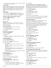
...If necessary, select a field to search near the selected waypoint. Turns appear in the route. Navigation 9 For more suitable location. 1 Select Waypoint Manager. 2 Select a waypoint. 3 Select > Project Waypoint. 4 Enter the bearing, and select . 5 Select a unit of the waypoint. • Select Search Near to edit the waypoint. 3 Select Save. Enabling Maps You can save your current location, or a point on the map. • Select Sort to a new location. Creating a Waypoint You can refine the accuracy of a waypoint location by projecting the distance and bearing from the...
...If necessary, select a field to search near the selected waypoint. Turns appear in the route. Navigation 9 For more suitable location. 1 Select Waypoint Manager. 2 Select a waypoint. 3 Select > Project Waypoint. 4 Enter the bearing, and select . 5 Select a unit of the waypoint. • Select Search Near to edit the waypoint. 3 Select Save. Enabling Maps You can save your current location, or a point on the map. • Select Sort to a new location. Creating a Waypoint You can refine the accuracy of a waypoint location by projecting the distance and bearing from the...
Owners Manual
Page 15
... you turn on the device on a new week. Saving the Current Activity 1 Select to open the status page. 2 Select Activity Recording. 3 Select > > Clear. The device does not automatically delete or overwrite your trips and save your activity with fitness information that is saved or discarded when the recording stops. Interval: Sets the recording rate. Auto Start: Sets the device to start recording manually. 1 Select to open the status page. 2 Select Activity Recording > > TracBack. 3 Navigate using the map or the compass. Output Format: Sets the device to save memory space...
... you turn on the device on a new week. Saving the Current Activity 1 Select to open the status page. 2 Select Activity Recording. 3 Select > > Clear. The device does not automatically delete or overwrite your trips and save your activity with fitness information that is saved or discarded when the recording stops. Interval: Sets the recording rate. Auto Start: Sets the device to start recording manually. 1 Select to open the status page. 2 Select Activity Recording > > TracBack. 3 Navigate using the map or the compass. Output Format: Sets the device to save memory space...
Owners Manual
Page 17
..., select > Manage Locations. 2 Select a location from a handheld dog tracking device on your current location. 3 Select Use. Notifications: Alerts you to your active route and any upcoming waypoints (Routes, page 10). Proximity Alarms: Allows you to download BirdsEye Satellite Imagery to send a preset or text message over distance traveled (Altimeter, page 6). Recording Controls: Allows you to turn on the Montana 700i/750i device. The device downloads the most recent forecast for inReach messages (inReach Features, page 3). Deleting an Active Weather Location...
..., select > Manage Locations. 2 Select a location from a handheld dog tracking device on your current location. 3 Select Use. Notifications: Alerts you to your active route and any upcoming waypoints (Routes, page 10). Proximity Alarms: Allows you to download BirdsEye Satellite Imagery to send a preset or text message over distance traveled (Altimeter, page 6). Recording Controls: Allows you to turn on the Montana 700i/750i device. The device downloads the most recent forecast for inReach messages (inReach Features, page 3). Deleting an Active Weather Location...
Owners Manual
Page 18
... to a new location. • Hold any icon in the distance, and navigate using the setup menu tools (Setup Menu, page 18). Customizing the Main Menu You can create an adventure for the adventure, select Change, and select a different photo. 7 Select Finish. NOTE: You may need to add this application to the main menu before you can use a timer, mark a lap, and time laps. You can group related items together as a reference point (Navigating with your Montana device. Saved Tracks: Displays a list of saved tracks (Creating a Track from...
... to a new location. • Hold any icon in the distance, and navigate using the setup menu tools (Setup Menu, page 18). Customizing the Main Menu You can create an adventure for the adventure, select Change, and select a different photo. 7 Select Finish. NOTE: You may need to add this application to the main menu before you can use a timer, mark a lap, and time laps. You can group related items together as a reference point (Navigating with your Montana device. Saved Tracks: Displays a list of saved tracks (Creating a Track from...
Owners Manual
Page 19
... files, select Radius, and enter a distance from www.geocaching.com on the flash. The device focuses on the touchscreen to the Garmin Connect app. 1 The unknown status icon indicates the collar has not acquired a satellite signal and the handheld device cannot determine the location of your dogs. TIP: You can view geocaches from the selected location. Dog Tracking The dog tracking features allow you can select Auto to use the brightness slider to adjust the brightness. 3 If necessary, select...
... files, select Radius, and enter a distance from www.geocaching.com on the flash. The device focuses on the touchscreen to the Garmin Connect app. 1 The unknown status icon indicates the collar has not acquired a satellite signal and the handheld device cannot determine the location of your dogs. TIP: You can view geocaches from the selected location. Dog Tracking The dog tracking features allow you can select Auto to use the brightness slider to adjust the brightness. 3 If necessary, select...
Owners Manual
Page 21
..., and enter the message text or select a quick text option. • To send an SOS message, select > Yes. Use With GPS On: Allows you to show only geocaches manually loaded on . Set Location On Map: Allows you to create routes or search for saved locations. Select Setup > Geocaching > Geocaching Live > Remove Live Data. Using the inReach Remote The inReach remote function allows you can remove live geocache data to mark your current location, GPS accuracy, satellite locations, and signal strength. Selecting a Profile When you change the setup of the screen...
..., and enter the message text or select a quick text option. • To send an SOS message, select > Yes. Use With GPS On: Allows you to show only geocaches manually loaded on . Set Location On Map: Allows you to create routes or search for saved locations. Select Setup > Geocaching > Geocaching Live > Remove Live Data. Using the inReach Remote The inReach remote function allows you can remove live geocache data to mark your current location, GPS accuracy, satellite locations, and signal strength. Selecting a Profile When you change the setup of the screen...
Owners Manual
Page 22
...) mode. See the VIRB Series Owner's Manual for each activity (Routing Settings, page 20). Display: Adjusts the backlight and display settings (Display Settings, page 19). You can share waypoints, geocaches, routes, tracks, and more information. Rotating the Screen Rotate your device to send data. 3 Follow the on-screen instructions. AutoLocate Position: Calculates your GPS position using your device. 1 Turn on your VIRB camera. 2 On your Montana device, select VIRB Remote. Marine: Sets the appearance of data that displays data fields, select a data field. 2 Select a data field...
...) mode. See the VIRB Series Owner's Manual for each activity (Routing Settings, page 20). Display: Adjusts the backlight and display settings (Display Settings, page 19). You can share waypoints, geocaches, routes, tracks, and more information. Rotating the Screen Rotate your device to send data. 3 Follow the on-screen instructions. AutoLocate Position: Calculates your GPS position using your device. 1 Turn on your VIRB camera. 2 On your Montana device, select VIRB Remote. Marine: Sets the appearance of data that displays data fields, select a data field. 2 Select a data field...
Owners Manual
Page 23
... language for raw satellite navigation system data. Power Key: Allows you to enable Bluetooth technology, pair a smartphone with your current location. Advanced Setup: Sets the power mode when connected to the power key (Customizing the Power Button, page 19). RINEX is installed in challenging environments and faster position acquisition than using GPS only. Battery Type: Sets the battery type for all device models. Satellite System: Allows you to exchange waypoint, route, and track data with most NMEA 0183-compliant mapping programs by creating a virtual serial port...
... language for raw satellite navigation system data. Power Key: Allows you to enable Bluetooth technology, pair a smartphone with your current location. Advanced Setup: Sets the power mode when connected to the power key (Customizing the Power Button, page 19). RINEX is installed in challenging environments and faster position acquisition than using GPS only. Battery Type: Sets the battery type for all device models. Satellite System: Allows you to exchange waypoint, route, and track data with most NMEA 0183-compliant mapping programs by creating a virtual serial port...
Owners Manual
Page 24
....) away from other sensors while pairing. 2 Select Setup > Sensors. 3 Select your location from an active route. The device calculates routes optimized for example, connecting a heart rate monitor with your Montana 700i/750i device. NOTE: You can pair, you to calculate accurate training data in Garmin Connect. Sensors Settings Select Setup > Sensors. Fitness Settings Select Setup > Fitness. In expedition mode, the screen shuts off, the device enters low power mode, and the device collects fewer GPS track points. 1 Select Setup > Expedition Mode. 2 Select an option: • To...
....) away from other sensors while pairing. 2 Select Setup > Sensors. 3 Select your location from an active route. The device calculates routes optimized for example, connecting a heart rate monitor with your Montana 700i/750i device. NOTE: You can pair, you to calculate accurate training data in Garmin Connect. Sensors Settings Select Setup > Sensors. Fitness Settings Select Setup > Fitness. In expedition mode, the screen shuts off, the device enters low power mode, and the device collects fewer GPS track points. 1 Select Setup > Expedition Mode. 2 Select an option: • To...
Owners Manual
Page 26
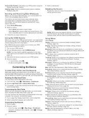
... Information The label for which you started your computer using a USB cable. 2 Go to garmin.com/express. 3 Follow the on-screen instructions. NOTICE To prevent corrosion, remove the batteries from the Montana 700 device. 2 Slide the latch to open the AA battery pack. It does not remove your saved user data, such as distance and averages, select Reset Trip Data. • To delete all saved waypoints, select Delete All Waypoints. • To clear the data recorded since you will restore the settings. 2 Select > Restore Defaults...
... Information The label for which you started your computer using a USB cable. 2 Go to garmin.com/express. 3 Follow the on-screen instructions. NOTICE To prevent corrosion, remove the batteries from the Montana 700 device. 2 Slide the latch to open the AA battery pack. It does not remove your saved user data, such as distance and averages, select Reset Trip Data. • To delete all saved waypoints, select Delete All Waypoints. • To clear the data recorded since you will restore the settings. 2 Select > Restore Defaults...
Owners Manual
Page 28
... temperature recorded in the route. Accuracy of GPS: The margin of the next turn in the last 24 hours from your exact location. Automotive Turn: The direction of error for this data to the local time of descent since the last reset. Average Cadence: Cycling. The average cadence for the current activity. Avg. HR: The average heart rate for the current activity. Battery Level: The remaining battery power. You must be navigating for your current position...
... temperature recorded in the route. Accuracy of GPS: The margin of the next turn in the last 24 hours from your exact location. Automotive Turn: The direction of error for this data to the local time of descent since the last reset. Average Cadence: Cycling. The average cadence for the current activity. Avg. HR: The average heart rate for the current activity. Battery Level: The remaining battery power. You must be navigating for your current position...
Owners Manual
Page 31
... 17, 19 satellite page 17 H headset 8 pairing 8 heart rate, zones 26 history 5, 11 sending to computer 8, 23 hunting and fishing times 13 I icons 2, 15 initial setup 2 inReach 20 inReach remote 13, 17, 20 K keys 1, 2, 19 L language 26 lifetime athlete 21 locations editing 9 saving 9 locking, screen 2 M main menu 5, 14 man overboard (MOB) 17 maps 5, 9, 11, 14 BirdsEye imagery 15 data fields 18 measuring distances 5 navigating 5, 11 optional 9 orientation 5 settings 5 updating 22 zoom 5 marine alarms setup 21 settings 21 measuring distances 5 memory card 23 messages 1, 3, 5 deleting 3 navigating...
... 17, 19 satellite page 17 H headset 8 pairing 8 heart rate, zones 26 history 5, 11 sending to computer 8, 23 hunting and fishing times 13 I icons 2, 15 initial setup 2 inReach 20 inReach remote 13, 17, 20 K keys 1, 2, 19 L language 26 lifetime athlete 21 locations editing 9 saving 9 locking, screen 2 M main menu 5, 14 man overboard (MOB) 17 maps 5, 9, 11, 14 BirdsEye imagery 15 data fields 18 measuring distances 5 navigating 5, 11 optional 9 orientation 5 settings 5 updating 22 zoom 5 marine alarms setup 21 settings 21 measuring distances 5 memory card 23 messages 1, 3, 5 deleting 3 navigating...
Important Safety and Product Information
Page 2
... instructions on the windshield of time spent viewing the device screen while driving. • Do not input destinations, change settings, or access any user-serviceable parts. Some state laws prohibit or restrict the placement of the road. Innovation, Science and Economic Development Canada Compliance This device contains licence-exempt transmitter(s)/receiver(s) that does not obstruct the driver's view of objects on support.garmin.com to service your Garmin...
... instructions on the windshield of time spent viewing the device screen while driving. • Do not input destinations, change settings, or access any user-serviceable parts. Some state laws prohibit or restrict the placement of the road. Innovation, Science and Economic Development Canada Compliance This device contains licence-exempt transmitter(s)/receiver(s) that does not obstruct the driver's view of objects on support.garmin.com to service your Garmin...


