Owner's Manual
Page 63
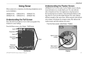
...colors indicate different strengths of sonar readings Transducer frequency or beam width Full Screen GPSMAP 400/500 Series Owner's Manual Water depth at current location Flasher 57 From the Home screen, select Sonar > Full Screen. Using Sonar When connected to a transducer, the following chartplotters... can be used as a ring that starts at the top and progresses clockwise. The scale indicates what is received at the depth indicated. It is organized as fishfinders: GPSMAP 431s GPSMAP 441s GPSMAP 531s GPSMAP 536s GPSMAP 541s GPSMAP 546s Understanding the Full...
...colors indicate different strengths of sonar readings Transducer frequency or beam width Full Screen GPSMAP 400/500 Series Owner's Manual Water depth at current location Flasher 57 From the Home screen, select Sonar > Full Screen. Using Sonar When connected to a transducer, the following chartplotters... can be used as a ring that starts at the top and progresses clockwise. The scale indicates what is received at the depth indicated. It is organized as fishfinders: GPSMAP 431s GPSMAP 441s GPSMAP 531s GPSMAP 536s GPSMAP 541s GPSMAP 546s Understanding the Full...
Owner's Manual
Page 47
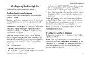
...(GPSMAP 431/441/531/541/536/546, including "s" models)-turn Simulator mode (page 6) on or off. A Garmin Product Support representative may ask you to use this feature to set simulator options, such as a troubleshooting tool. When On is selected, the chartplotter will...button is lost. Select Display > Color Mode to view additional information. GPS-view GPS satellites. • Skyview-view the GPS satellite constellation. • WAAS/EGNOS-toggle WAAS (in North America) or EGNOS GPSMAP 400/500 Series Owner's Manual Configuring the Chartplotter (in Europe) on whenever power...
...(GPSMAP 431/441/531/541/536/546, including "s" models)-turn Simulator mode (page 6) on or off. A Garmin Product Support representative may ask you to use this feature to set simulator options, such as a troubleshooting tool. When On is selected, the chartplotter will...button is lost. Select Display > Color Mode to view additional information. GPS-view GPS satellites. • Skyview-view the GPS satellite constellation. • WAAS/EGNOS-toggle WAAS (in North America) or EGNOS GPSMAP 400/500 Series Owner's Manual Configuring the Chartplotter (in Europe) on whenever power...


