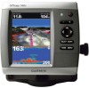
Garmin GPSMAP 546S Support Question
Garmin GPSMAP 546S Support Question
Find answers below for this question about Garmin GPSMAP 546S - Marine GPS Receiver.Need a Garmin GPSMAP 546S manual? We have 6 online manuals for this item!
Question posted by wbherbert on July 15th, 2011
How Do I View Time On The 546s
The person who posted this question about this Garmin product did not include a detailed explanation. Please use the "Request More Information" button to the right if more details would help you to answer this question.
Current Answers
Related Garmin GPSMAP 546S Manual Pages
Installation Instructions - Page 10

...550/551 (s): 5.0 in small increments. diagonal (12.7 cm), QVGA display with adjustable brightness, 320 × 240 pixels.
GPSMAP 526/536/546/556 (s): High-sensitivity 12 parallel channel WAAS-capable receiver. Acquisition Times: (Average acquisition times for a stationary receiver with adjustable brightness, 640 × 480 pixels, capable of the boat and put the transducer at a slow speed...
Installation Instructions - Page 11
...Receive PGN List Group Function Product Information Water Depth Speed - Route/WP information GNSS DOPs GNSS Sats in View Wind Data
Compatible GPSMAP 400/500 series chartplotters are supported by the GPSMAP 525s/526s/535s/536s/545s/546s... can purchase complete information about National Marine Electronics Association (NMEA) format and sentences from: NMEA Seven Riggs Avenue Severna Park, MD 21146 USA...
Owner's Manual - Page 4
...the Keypad 5 Acquiring GPS Satellite Signals 5 Using Simulator Mode 5 Viewing System Information 6 ...Viewing Information 36 Viewing a Compass 36 Viewing Numbers 36 Viewing Trip Information 37 Viewing and Customizing Engine Gauges 37 Viewing and Synchronizing Fuel Gauges 40 Viewing and Customizing Wind Gauges 41 Viewing Tide-station Information 42 Viewing Current Information 43
GPSMAP...
Owner's Manual - Page 26

... the Range (+) key, or set the detail level higher (page 13). GPSMAP 400/500 Series Owner's Manual
Viewing Aerial Photos
Preprogrammed BlueChart g2 Vision SD cards contain aerial photographs of many landmarks... help orient yourself to your BlueChart g2 Vision region, either zoom in and out while viewing the aerial photo on the full screen. Photo Overlay Off Land Only Photo Overlay
Photo...
Owner's Manual - Page 32
...Mariner's Eye 3D.
3. Select Time To to sound an alarm if AIS determines that is used with AIS. Setting the Safe-zone Collision Alarm The safe-zone collision alarm can view the AIS signal status, MMSI, GPS speed, GPS... an AIS vessel. Select a distance.
6. Press SELECT. 4.
Select a time.
26
GPSMAP 400/500 Series Owner's Manual Select AIS Vessel. The Off setting disables the...
Owner's Manual - Page 41

...use the SD card on BlueChart g2 Vision-compatible Garmin GPS units and when using HomePort. Optional BlueChart g2 Vision ...Mariner's Eye 3D-provides a view from the SD card to your computer for backup. The BlueChart g2 Vision Mariner's Eye 3D is installed on your PC.
Navigating with NMEA 2000 compatible chartplotters (GPSMAP 441/441s, GPSMAP 536/536s, GPSMAP 541/541s, and GPSMAP 546/546s...
Owner's Manual - Page 48
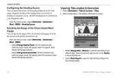
... to move the time line.
• Select Show Report to view tide information for...the close hauled wind gauge for the selected station.
42
GPSMAP 400/500 Series Owner's Manual Select Information > Tides &...Viewing Tide-station Information
1. Magnetic heading is the heading data received from a heading (or magnetic) sensor, and GPS heading data is shown.
• Select Change Date > Manual to view...
Owner's Manual - Page 53
..., type, MMSI, distance from your boat, or the time the call was received. If a second call in the Garmin\UserData folder.
2.
Select Add Contact. 2. GPSMAP 400/500 Series Owner's Manual
47 To add a DSC contact: 1.
Select Waypoints, Routes, Saved Tracks, or All.
3.
Viewing Other Vessels
To view information about all waypoints, routes, and tracks: 1. See...
Owner's Manual - Page 54
...to view additional information.
WAAS/EGNOS can provide more-accurate
48
GPS position information. GPSMAP 400...view system information and reset factory settings. Select an event to view depth and water temperature information. Auto Power-turn on or off . Note: You must be receiving... tool. The speed filter averages the speed of time for depth, temperature, distance, speed, elevation, ...
Owner's Manual - Page 59
...must be on time to arrival or distance to arrival.
• Change Time/Change Distance-if you want arrival alarms to sound when the GPS location accuracy falls outside the specified value.
GPSMAP 400/500 Series ... Configure > Alarms > Navigation. Note: You must be receiving NMEA sonar depth data or have Activation set to Time, select Change Time to change the time or distance.
Owner's Manual - Page 65
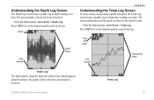
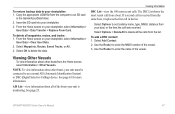
... Screen
The Depth Log screen keeps a graphic log of temperature readings over time.
Temp Log
GPSMAP 400/500 Series Owner's Manual
59
Temp and depth
Time elapsed
Temperature range
Depth Log
The depth appears along the right side, and the time elapsed appears along the bottom. Press MENU to the left as information is...
Owner's Manual - Page 77

... projected locations received from the National Hurricane Center.
GPSMAP 400/500 Series Owner's Manual 71 The darkened dots on the chart indicate marine weather warning zones. Marine Warning
Hurricane
...WX Weather and Audio
Understanding Marine Warnings When a Marine Warning is issued, the area for a county, the county is highlighted in red. To view information about the warning, select...
Owner's Manual - Page 84
Appendix
Acquisition Times: (Average acquisition times for a stationary receiver with a clear view of the sky) GPSMAP 431/431s GPSMAP 441/441s GPSMAP 531/531s GPSMAP 541/541s
Warm:* Approximately 1 second Cold:** Approximately 38 seconds
GPSMAP 536/536s GPSMAP 546/546s
Warm:* Approximately 15 seconds Cold:** ...off, or it has been turned off for more than 2 weeks. GPS Accuracy: Position:
Owner's Manual - Page 91

...drag 53 arrival 53 battery 53 clock 53 collision 26 deep water 53 fish 54 fuel 54 GPS accuracy 53 navigation 53 off course 53 shallow water 53 sonar 53 water temp 54 weather 54 ... alarms 39 viewing 37 Enter Coordinates 30
F
factory settings, restoring 6 fish eye 3D 18
settings 18 fishing chart 19
AIS 27 MARPA 27 fishing information 73
GPSMAP 400/500 Series Owner's Manual 85 Time 49 barometric ...
Owner's Manual - Page 92
...fuel gauges
synchronizing 40 viewing 40 full screen, sonar 57 Full Screen Map 9 fuse 78
G
gain 61 Garmin Data Transfer 51 go to 28 GPS 5, 48, 78 GPS heading 42 Grid ... overboard 30, 65 Manual Zoom 61 map datum 49 MapSource data 44 Mariner's Eye 3D
AIS 27 MARPA 27 mariner's eye 3D colors 17 mark current location 30
MARK key 5 MARPA
.... Heading 25
Q
quick links i
GPSMAP 400/500 Series Owner's Manual
Owner's Manual - Page 5
... Sonar 52 Advanced Sonar Settings 53
Using Digital Selective Calling (DSC 55 Using the Chartplotter with a VHF Radio 55 Adding a DSC Contact 56 Viewing the DSC List 56 Receiving Distress Calls 56 Man-Overboard Distress Calls Initiated from a VHF Radio........ 57 Man-Overboard Distress Calls Initiated from the Chartplotter.... 57 Position Tracking...
Owner's Manual - Page 26

...orient yourself to your BlueChart g2 Vision region, either zoom in and out while viewing the aerial photo on the full screen. GPSMAP 400/500 Series Owner's Manual
Using Charts
Note: When enabled, the high-resolution...50% 20
Photo Overlay at closer zoom levels. Viewing Aerial Photos
Preprogrammed BlueChart g2 Vision SD cards contain aerial photographs of many landmarks, marinas, and harbors.
Owner's Manual - Page 31
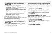
... You can view the AIS signal status, MMSI, GPS speed, GPS heading, and other information that appears using a trail, or turn the trail off.
Select AIS Vessel > Activate Target. GPSMAP 400/500 Series Owner's Manual
25 Heading-allows you to set the projected heading time
for an AIS Vessel Note: The Fishing chart and Mariner's Eye...
Owner's Manual - Page 46

...Viewing Other Vessels
To view information about all waypoints, routes, and tracks: 1. Note: To view information about other boats from the list.
40
GPSMAP 400/500 Series Owner's Manual
If a second call was received...by name, type, MMSI, distance from your boat, or the time the call is received from a boat. Viewing Information
To delete all of the boats your unit is monitoring. ...
Owner's Manual - Page 76
... acquisition times for a stationary receiver with a clear view of the sky.) GPSMAP 430/430s GPSMAP 440/440s GPSMAP 530/530s GPSMAP 535/535s GPSMAP 530/540s GPSMAP 535/545s
Warm:* Approximately 15 seconds Cold:** Approximately 45 seconds
GPSMAP 431/431s GPSMAP 441/441s GPSMAP 531/531s GPSMAP 541/541s
Warm:* Approximately 1 second Cold:** Approximately 38 seconds
GPSMAP 536/536s GPSMAP 546/546s
Warm...
Similar Questions

How Do I Go Into Simulation Mode On A Garmin Marine Gps Modle741xs
how do I use simulation mode on a garmin 741xs marine ver
how do I use simulation mode on a garmin 741xs marine ver
(Posted by Curthupp 6 years ago)

No Depth Readings On Gpsmap546s
Have cleaned pins on data cable, transducer, both hot wire and ground connection on data cable. Boug...
Have cleaned pins on data cable, transducer, both hot wire and ground connection on data cable. Boug...
(Posted by sue1953bc 7 years ago)


Cannot Update Software On 546s
Followed all the steps to load software update. I see it load and it reboots but then just hangs wit...
Followed all the steps to load software update. I see it load and it reboots but then just hangs wit...
(Posted by BAUERBK 11 years ago)