Get support for Garmin GPSMAP 546S - Marine GPS Receiver

Garmin GPSMAP 546S Support Question

Garmin GPSMAP 546S Support Question

Find answers below for this question about Garmin GPSMAP 546S - Marine GPS Receiver.
Need a Garmin GPSMAP 546S manual? We have 6 online manuals for this item!
Question posted by sue1953bc on January 16th, 2017

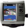
No Depth Readings On Gpsmap546s

Have cleaned pins on data cable, transducer, both hot wire and ground connection on data cable. Bought new transducer and Data cable still same problem. The only way to get a depth number to show up on the screen was to change depth to manual setting of depth, then the display would show a number in the provided spaces on the screen. Will not show any numbers when set to auto depth. What is wrong?

Current Answers

Answer #1: Posted by techyagent on January 17th, 2017 7:58 AM
This answer was accepted by the poster of the original question.
techyagent

Member since:
June 17th, 2014

Points: 4,799,800
1,110
points
Depth Reading Troubleshooting

Here are some suggestions that could solve the problem and prevent you from having to be without your unit!

* Losing Depth When the Boat is Moving: This is likely due to cavitation (turbulence) in the water surrounding the transducer. You may need to move the transducer lower in the water or to another location. The transducer cannot send or receive signals through air bubbles.

* Losing Depth in Shallow Water: It can sometimes be difficult for a high-powered unit to capture the lightning-fast return in shallow water. Turn off the automatic sensitivity setting and manually reduce the sensitivity until the unit locks onto the bottom.

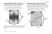
* Losing bottom over weeds: When trolling over weed beds in 20ft of water or less, you may experience vertical bars, loss of the chart picture, or the digital depth. First, do a soft reset of the unit. Click here to find the reset procedure for your unit. Then go to the Full Sonar Chart screen. Press Menu and select Sonar Features. Now turn the Chart Manual Mode to On. This will leave everything in Automatic Mode except the depth. Now go back to the main menu and set the depth range for the depth you are in such as 0-20 feet.

* Losing Depth When Another Sonar Unit is On: If two or more sonar units using the same transducer frequency are operating at the same time, one or more of them may lose the depth reading to the interference. It is like two radio stations trying to both broadcast on 97.3FM. In shallow water, if the transducers are far enough apart, you may be able to operate them together. However, the deeper the water, the wider the beams spread out. When they cross each other, the interference occurs.

* No Depth Reading at Any Time: Clean the bottom of the transducer. Make sure the beam is shooting down (see picture below). Check your transducer connection to the back of the unit. Check the connector pins for corrosion. Check the cable for frayed or pinched areas.

* Phone a Friend: If a friend has the same transducer and power connection on their boat, try your unit on their cables. If your unit works on the other boat, you transducer may need to be replaced.

Check this link for more help

http://www.boatus.com/magazine/archives/troubleshooting-fish-finders.asp

Thanks


Techygirl

Related Garmin GPSMAP 546S Manual Pages

Installation Instructions - Page 8

... or marine dealer. If you can use the Garmin CANet with other connected NMEA 2000-compatible devices. Connecting the Wiring Harness to a Garmin CANet Device If your compatible Garmin sounder or fishfinder. A standard NMEA 0183 connection only allows depth, temperature, and speed information to be shared with NMEA 2000 connectors or cables. NOTE: NMEA 2000-compatible GPSMAP 400...
Installation Instructions - Page 9

... and hold the POWER key until the chartplotter beeps and turns on. Connecting Cables to the Chartplotter Use the diagrams below the water line. You cannot get a depth or distance reading when the transducer is necessary to help identify the connectors on your chartplotter. GPSMAP 400/500 Series Installation Instructions  When you place your boat in...
Installation Instructions - Page 10

...transducer at greater risk of the boat. GPSMAP 520/521/530/531/540/541/550/551 (s): 5.0 in . GPSMAP 526/536/546/556 (s): High-sensitivity 12 parallel channel WAAS-capable receiver. Update Rate: 1/second, continuous GPS... 55ºC) Compass-Safe Distances: Model Number GPSMAP 526/536/546/556 GPSMAP 421/431/441/451 GPSMAP 521/531/541/551 GPSMAP 420/430/440/450 GPSMAP 520/530/540/550/525/535/545...
Installation Instructions - Page 11

... Transmit/Receive PGN List Group Function Product Information Vessel Heading Engine Parameters - Rapid Update Engine Parameters - Water Referenced Water Depth Position, Rapid Update COG/SOG Rapid Update GNSS - Route/WP information GNSS DOPs GNSS Sats in View Wind Data Compatible GPSMAP 400/500 series chartplotters are supported by the GPSMAP 525s/526s/535s/536s/545s/546s...
Owner's Manual - Page 4

... Settings 3 Adjusting the Backlight 4 Using the Keypad 5 Acquiring GPS Satellite Signals 5 Using Simulator Mode 5 Viewing System Information 6 Restoring...15 Using Perspective 3D 15 ii Using Mariner's Eye 3D 16 Using Fish Eye 3D...Indicators 21 Detailed Road and POI Data 21 Using Automatic Guidance 22 Using... 36 Viewing a Compass 36 Viewing Numbers 36 Viewing Trip Information 37 Viewing ...
Owner's Manual - Page 32

... can view the AIS signal status, MMSI, GPS speed, GPS heading, and other information that a target will...boat. to select an AIS vessel. Select a time. 26 GPSMAP 400/500 Series Owner's Manual Use the Rocker to 2.0 mi...Information about a targeted AIS vessel. 1. Select Navigation Chart, Fishing Chart, Perspective 3D, or Mariner's Eye 3D. 3. Use the Rocker to 3.0 km, or from 500 ft. Select a...
Owner's Manual - Page 41

... chart data and specified boat safe depth to determine the best course to your computer for backup. NOTE: Autopilot can only use the SD card on a large metal object before handling the card to prevent damage to the card. Navigating with NMEA 2000 compatible chartplotters (GPSMAP 441/441s, GPSMAP 536/536s, GPSMAP 541/541s, and GPSMAP 546/546s).
Owner's Manual - Page 54

...or Auto. Auto Power-turn Simulator mode (page 5) on or off. GPS-view GPS satellites. • Skyview-view the GPS satellite constellation • WAAS/EGNOS-toggle WAAS (in North America) or... depth and water temperature information. Note: You must be receiving NMEA sonar depth data or have a built-in Europe) on or off with a temperature-capable transducer to Card button is lost. GPSMAP ...
Owner's Manual - Page 59

... select Configure > Alarms > Sonar. GPSMAP 400/500 Series Owner's Manual 53 GPS Accuracy-set an alarm to arrival. ...transducer to set the number of minutes before arrival that the alarm should sound. The unit must be on time to arrival or distance to sound when the GPS location accuracy falls outside the specified value. Note: You must be receiving NMEA sonar depth data...
Owner's Manual - Page 60

...). 2. To adjust the Keel Offset: 1. Setting Weather Alarms Note: You must be connected to an external fuel sensor, such as a positive number. Enter a positive number to offset for a large vessel that is installed at the water line, measure the distance from the transducer to the water line. You can configure your boat, from the...
Owner's Manual - Page 65

Temp Log GPSMAP 400/500 Series Owner's Manual 59 Depth Time elapsed Depth range Using Sonar Understanding the Temp Log Screen If you are shown in the top-left as information is received. The current temperature and the depth are using a temperature-capable transducer, the Temp Log screen keeps a graphic log of depth readings over time. Press MENU to...
Owner's Manual - Page 84

GPS Accuracy: Position: Appendix Acquisition Times: (Average acquisition times for a stationary receiver with a clear view of the sky) GPSMAP 431/431s GPSMAP 441/441s GPSMAP 531/531s GPSMAP 541/541s Warm:* Approximately 1 second Cold:** Approximately 38 seconds GPSMAP 536/536s GPSMAP 546/546s Warm:* Approximately 15 seconds Cold:** Approximately 38 seconds *Warm: your unit is at or near the last ...
Owner's Manual - Page 91

... deep water 53 fish 54 fuel 54 GPS accuracy 53 navigation 53 off course 53 ...number of engines 39 status alarms 39 viewing 37 Enter Coordinates 30 F factory settings, restoring 6 fish eye 3D 18 settings 18 fishing chart 19 AIS 27 MARPA 27 fishing information 73 GPSMAP...data 10 charts detail 13 fish eye 3D 18 fishing 19 mariner's eye 3D 16 navigation 8 settings 12 cleaning the unit 82 Clear User Data...
Owner's Manual - Page 92

... gain 61 Garmin Data Transfer 51 go to 28 GPS 5, 48, 78 GPS heading 42 Grid (North) 49 grid coordinates creating waypoints using 30 ground wind 41 guide to...number 6 K keel offset 54 keypad 5 L Label Devices 52 Lane Width 16, 18 Language 49 lightning information 70 Light Sectors 14 low-pressure center 72 M magnetic heading 42 man overboard 30, 65 Manual Zoom 61 map datum 49 MapSource data 44 Mariner...
Owner's Manual - Page 4

...Unit Settings 3 Adjusting the Backlight 4 Using the Keypad 5 Acquiring GPS Satellite Signals 5 Using Simulator Mode 6 Viewing System Information 6 Restoring ...Chart 15 Using Perspective 3D 15 ii Using Mariner's Eye 3D 16 Using Fish Eye 3D ... Information 21 Detailed Road and POI Data 21 Using Automatic Guidance 21 Using ...34 Viewing Numbers 34 Viewing Trip Information 35 Viewing Fuel...
Owner's Manual - Page 31

..., MMSI, GPS speed, GPS heading, and other information that appears using a trail, or turn the trail off. GPSMAP 400/500 Series Owner's Manual 25 Select AIS Vessel > Activate Target. Select AIS Vessel. Activating a Target for an AIS Vessel Note: The Fishing chart and Mariner's Eye 3D are available with a preprogrammed BlueChart g2 Vision data card...
Owner's Manual - Page 39

...with enhanced bottom contours and without navigational data. GPSMAP 400/500 Series Owner's Manual 33 Note: You cannot transfer BlueChart g2 Vision data from above and behind the boat for...Autopilot When you are connected to the information on BlueChart g2 Vision-compatible Garmin GPS units. The BlueChart g2 Vision Mariner's Eye 3D is more detailed than the preloaded data. • Fish ...
Owner's Manual - Page 52

...fish only. 46 GPSMAP 400/500 Series Owner's Manual Note: You must be receiving NMEA sonar depth data or using the system (GPS) clock. Off ...the transducer reports a temperature that is greater than the specified value. Anchor Drag-set an alarm to sound when the GPS ...Change Time to work. Setting System Alarms To set the number of the specified symbols. -sounds an alarm for all fish...
Owner's Manual - Page 53

... Weather and a connected Garmin XM WX weather receiver to indicate the fuel level at which the alarm should sound. To enable the Total Fuel Onboard alarm and set the fuel alarm level: 1. GPSMAP 400/500 Series Owner's Manual 47 Setting Weather Alarms Note: You must be connected to measure depth from the transducer location to the...
Owner's Manual - Page 83

... arrival 45 battery 46 clock 46 collision 26, 49 deep water 46 fish 46 fuel 47 GPS accuracy 46 navigation 45 safe-zone 49 shallow water 46 sonar 46 water temp 46 weather 47... mariner's eye 3D 16 navigation 8 settings 12 cleaning the unit 74 Clear User Data 37 collision alarm 26, 49 colors, hazard 17 Color Scheme 53 Communications 44 Compass 34 compass rose 12 contact information, Garmin iv GPSMAP ...

Similar Questions

Can't Get Depth Reading.
i have no depth reading.
(Posted by rdls92 7 years ago)
Data Bars At Top Of Main Screen
How do d get the data bars to show my current location
(Posted by rddries 9 years ago)
How Do You Change The Position Settings?
The other day we went out with #s from a local capt the decimal points did not match up and the posi...
(Posted by jenn222 11 years ago)
Ask a New Question
Use the box below to post a new question about this Garmin product .
Points & Prizes
  • You can earn points for nearly everything you do on HelpOwl.com
  • You can trade in those points for gift cards at leading retailers such as Amazon.com and Walmart
  • It's that simple!
See How it Works
Create a Free Account

Garmin Manuals

Find free Garmin GPSMAP 546S - Marine GPS Receiver manuals and user guides available at ManualOwl.com. Try out our unique manual viewer allowing you to interact with manuals from directly within your browser!

Garmin Reviews

View thousands of Garmin user reviews and customer ratings available at ReviewOwl.com.

Contact Information

Complete Garmin customer service contact information including steps to reach representatives, hours of operation, customer support links and more from ContactHelp.com.

Scoreboard Ratings

See detailed Garmin customer service rankings, employee comments and much more from our sister site.