Garmin GPSMAP 546S Support Question
Garmin GPSMAP 546S Support Question
Find answers below for this question about Garmin GPSMAP 546S - Marine GPS Receiver.Need a Garmin GPSMAP 546S manual? We have 6 online manuals for this item!
Question posted by chrisfoster0 on April 14th, 2013
What Could Cause My Numbers To Be Drastically Off When I Know Correct Distance
The person who posted this question about this Garmin product did not include a detailed explanation. Please use the "Request More Information" button to the right if more details would help you to answer this question.
Current Answers
Related Garmin GPSMAP 546S Manual Pages
Flush Mount Kit Instructions (multilingual) - Page 1
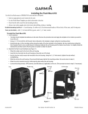
...nuts
October 2007
Hex bolts Figure 1
Part Number 190-00553-01 Rev. Tools (not included... correctly, it will snap into place within the unit housing.
• Connect the wiring harness, GPS ...antenna, and XM antenna (if applicable) to begin cutting the mounting surface.
• Using the jig saw , and a 9/32" (7 mm) wrench. EN
Installing the Flush Mount Kit
Use this kit to flush mount a GPSMAP...
Installation Instructions - Page 3
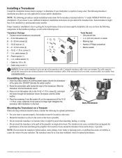
...tight. The transducer can cause cavitation that creates air bubbles or causes the water to any part of the boat and damage the propeller. GPSMAP 400/500 Series Installation ... 1.75 in . (9.5 mm) wrench or socket
E
• Masking tape
• Number 2 Phillips screwdriver
F
H
• Marine sealant
I - Insert the rubber washer (H) and the plastic spacer (G) into the transducer...
Installation Instructions - Page 4
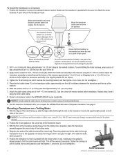
...cause cavitation that the transducer is below an aluminum hull. Tighten the 10-32 locking nut until it .)
5. Notice: Avoid routing the cable close to the transom using one third of the distance...(25 mm) from the point of the transducer
GPSMAP 400/500 Series Installation Instructions Apply marine sealant to the GPSMAP 400/500 series chartplotter. Attach the transducer assembly to ...
Installation Instructions - Page 10

....
4. It might have to move the transducer to 55ºC)
Compass-Safe Distances:
Model Number
GPSMAP 526/536/546/556 GPSMAP 421/431/441/451 GPSMAP 521/531/541/551 GPSMAP 420/430/440/450 GPSMAP 520/530/540/550/525/535/545/555
Compass-Safe Distance 20 in. (50 cm)
26 in. (65) cm
30 in. (75 cm...
Quick Reference Guide - Page 2

...your present location: 1.
press to return to mark a waypoint.
The bar under the number represents that distance on the unit, press and release the Power key. From the Navigation chart, use ...2009
190-01074-01 Rev. Acquiring GPS Satellite Signals When you want to switch between modes.
Press left or right on the unit, the GPS receiver must collect satellite data and establish ...
Owner's Manual - Page 4
... Initializing Unit Settings 3 Adjusting the Backlight 4 Using the Keypad 5 Acquiring GPS Satellite Signals 5 Using Simulator Mode 5 Viewing System Information 6 Restoring the ...Navigation Chart 15 Using Perspective 3D 15
ii
Using Mariner's Eye 3D 16 Using Fish Eye 3D 18 ...
Viewing Information 36 Viewing a Compass 36 Viewing Numbers 36 Viewing Trip Information 37 Viewing and Customizing ...
Owner's Manual - Page 15

... show or hide cruising, navigation, fishing, fuel, or sailing numbers. Waypoints & Tracks-view, add, and configure waypoints (page ...GPS Speed, GPS Heading, Depth, and GPS Position data bar on the cruising data bar.
Stop Navigation-stop navigating to a destination. GPSMAP 400/500 Series Owner's Manual
Using Charts
Data Bars-show on or off . Data bars
• Cruising-turn the Distance...
Owner's Manual - Page 22
...connected to provide distance measurement.
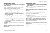
• Lane Width-adjusts the width of the course line drawn when navigating.
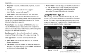
Data Bars (page 9)-show or hide the numbers for additional information...in unfamiliar harbors or anchorages. Mariner's Eye 3D
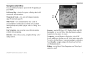
Navigation Chart
GPSMAP 400/500 Series Owner's Manual
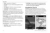
Using Mariner's Eye 3D
A BlueChart g2 Vision SD card offers Mariner's Eye 3D, which provides...
Owner's Manual - Page 32
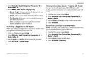
...view the AIS signal status, MMSI, GPS speed, GPS heading, and other information that a ...AIS determines that is used with AIS. Select a time.
26
GPSMAP 400/500 Series Owner's Manual Deactivating a Target for collision avoidance,...to all 3D chart views.
1. Select a distance.
6. Select Navigation Chart, Fishing Chart, Perspective 3D, or
Mariner's Eye 3D. 3.
Select AIS Vessel >...
Owner's Manual - Page 59
...GPSMAP 400/500 Series Owner's Manual
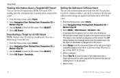
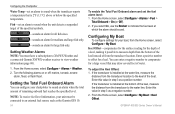
53 Setting Navigation Alarms To set a sonar alarm from the Home screen, select Configure > Alarms > Sonar. GPS Accuracy-set the number of minutes before arrival that the alarm should sound.
Note: You must be receiving... to arrival or distance to arrival.
• Change Time/Change Distance-if you have Activation set the distance before arrival that ...
Owner's Manual - Page 60
... alarms on or off: marine, tornado, severe
storm, ...distance from the transducer location. To adjust the Keel Offset: 1. Enter this value in step 3 as a positive number...number.
2. If the transducer is 2°F (1.1°C) above or below the specified temperature. NOTE: To receive fuel-level information, your boat, from the transducer to view weather information (page 68).
1.
GPSMAP...
Owner's Manual - Page 91

... 53 fish 54 fuel 54 GPS accuracy 53 navigation 53 off course... 52 Display 48, 77 Display Range 25 distance, measuring 31 Distress Calls 64 DSC 56,... 48 engine gauges
customizing limits 38 selecting the number of engines 39 status alarms 39 viewing 37...AIS 27 MARPA 27 fishing information 73
GPSMAP 400/500 Series Owner's Manual 85 Time...13 fish eye 3D 18 fishing 19 mariner's eye 3D 16 navigation 8 settings...
Owner's Manual - Page 92
... heading 42 man overboard 30, 65 Manual Zoom 61 map datum 49 MapSource data 44 Mariner's Eye 3D
AIS 27 MARPA 27 mariner's eye 3D colors 17 mark current location 30
MARK key 5 MARPA
threats 27 measuring distance 31 MENU key 5 messages 79 move a waypoint 30 My Boat 54
N
Navaid Type 14 Navigate...
Owner's Manual - Page 4
... Initializing Unit Settings 3 Adjusting the Backlight 4 Using the Keypad 5 Acquiring GPS Satellite Signals 5 Using Simulator Mode 6 Viewing System Information 6 Restoring the ...Navigation Chart 15 Using Perspective 3D 15
ii
Using Mariner's Eye 3D 16 Using Fish Eye 3D 18 ...
Viewing Information 34 Viewing a Compass 34 Viewing Numbers 34 Viewing Trip Information 35 Viewing Fuel Gauges ...
Owner's Manual - Page 15
...turn the Distance to a destination. Full Screen Map-view the Navigation or Fishing chart in fullscreen mode, without numbers. GPSMAP 400/...500 Series Owner's Manual
Using Charts
Data bars
• Cruising-turn on or off . Waypoints & Tracks-view, add, and configure waypoints (page 29) and tracks (page 31). Select Auto to turn the GPS Speed, GPS Heading, Depth, and GPS...
Owner's Manual - Page 22
...cruising, navigation, fishing, fuel, sailing numbers, or compass tape. Using Charts
•...connected to a weather module and you have been saved.
Mariner's Eye 3D
Navigation Chart
16
GPSMAP 400/500 Series Owner's Manual Weather Radar-turn tracks on ... to your unit must be connected to provide distance measurement.
• Lane Width-adjusts the width of tracks that have...
Owner's Manual - Page 31
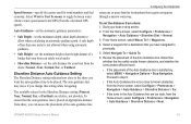
... distance from your location in which AIS vessels appear.
• Details-hides or shows details about a targeted AIS vessel.
1. Select Navigation Chart, Fishing Chart, Perspective 3D, or
Mariner's...GPS heading, and other information that appears using a trail, or turn the trail off. Use the Rocker and SELECT button to select the AIS vessel. 4. From the Home screen, select Charts. 2.
GPSMAP...
Owner's Manual - Page 49
... navigating.
GPSMAP 400/500 Series Owner's Manual
43 Select a waypoint for your boat from the shore: Nearest, Near, Normal, Far, or Farthest. The available values for wind numbers and fuel economy. From Home screen, select Where To? > Waypoints.
4. Auto Guidance-set the automatic guidance parameters:
• Safe Depth-set the distance from the...
Owner's Manual - Page 52
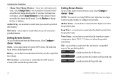
...than the specified value. If you have Activation set to Time, select Change Time to set the number of the specified symbols.
-sounds an alarm for all fish sizes.
-sounds an alarm for ...to work. Use the Rocker to set the distance before arrival that the alarm should sound.
Note: You must be receiving NMEA sonar depth data or using the system (GPS) clock.
Water Temp-set an alarm to...
Owner's Manual - Page 53
...GPSMAP 400/500 Series Owner's Manual
47 Turn the following alarms on the bottom of water. To receive fuel-level information, your boat, from the transducer location.
Enter a positive number to indicate the fuel level at
which the alarm should sound. Use the Rocker to enter the measured distance... number.
Enter a negative number to the water line (transducer installed on or off: marine...
Similar Questions

How Do I Go Into Simulation Mode On A Garmin Marine Gps Modle741xs
how do I use simulation mode on a garmin 741xs marine ver
how do I use simulation mode on a garmin 741xs marine ver
(Posted by Curthupp 6 years ago)

No Depth Readings On Gpsmap546s
Have cleaned pins on data cable, transducer, both hot wire and ground connection on data cable. Boug...
Have cleaned pins on data cable, transducer, both hot wire and ground connection on data cable. Boug...
(Posted by sue1953bc 7 years ago)

My New Gpsmap 740 Displays Inaccurate Gps Heading Information. Cause?
(Posted by Kirkehasson 11 years ago)

Mapping/measuring Distance/area
I'm looking for ahand-heldGPS unit that is in Spanish andthat can be used in mappingsections of land...
I'm looking for ahand-heldGPS unit that is in Spanish andthat can be used in mappingsections of land...
(Posted by amandrews07 12 years ago)

Correct In-line Fuse For 3206 C? Mine Has 2a And Has Blown Twice.
The power supply for my Garmin 3206C has a 2A in-line fuse. It has blown twice, which is very inconv...
The power supply for my Garmin 3206C has a 2A in-line fuse. It has blown twice, which is very inconv...
(Posted by bbsea 12 years ago)