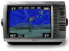
Garmin GPSMAP 4210 Support Question
Garmin GPSMAP 4210 Support Question
Find answers below for this question about Garmin GPSMAP 4210.Need a Garmin GPSMAP 4210 manual? We have 7 online manuals for this item!
Question posted by jenn222 on May 29th, 2012
How Do You Change The Position Settings?
The other day we went out with #s from a local capt the decimal points did not match up and the position I put in was 12 miles away from where I wanted to be. How do i adjust the settings so that I can put the #s in correctly?
Current Answers
Related Garmin GPSMAP 4210 Manual Pages
Owner's Manual - Page 4
... Initializing Chartplotter Settings 2 Acquiring GPS Satellite Signals 3 Adjusting the Backlight 3 Adjusting the Color Mode 3 Inserting and Removing SD Cards 3 Restoring Original Factory Settings 4 Understanding the Home Screen 5
Using Charts 6 Using the Navigation Chart 6 Using Perspective 3D 12 Using Radar Overlay 13 Using Tracks 13 Using BlueChart g2 Vision 15 Using Mariner's Eye 3D...
Owner's Manual - Page 8
... of actual satellite signals.
1.
Caution: Do not try to set speed, track control (simulated heading), position, simulator time, and
simulator date.
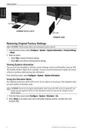
GPSMAP 4000 Series Owner's Manual Getting Started
Getting Started
Card label
GPSMAP 4210 or 4212
Card label GPSMAP 4208
Restoring Original Factory Settings
Caution: This procedure deletes any information you have entered.
1. The...
Owner's Manual - Page 11
... Some common symbols you want to , the following:*
Dangerous Rock
Exposed Rock
Beacon
Pilot Boarding Area
Airport/Seaplane Base Buoy
Anchorage Berth
Precautionary Area
Anchoring Prohibited
Radio Report Point
Exposed Wreck
Recommended Anchorage
Fishing Harbor
Rescue Station
Fishing Prohibited
Tide Station
Information
Yacht Harbor
Current Station
Marine Services
*Some symbols...
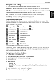
Owner's Manual - Page 13

...level
Detailed tide station information
Changing the Navigation Chart Settings From the Home screen, select Charts > Navigation Chart > Menu > Chart Setup. Service Points-turns the display of ... display of marine service points on or off .
Roses-displays a compass rose around your boat, indicating compass direction.
GPSMAP 4000 Series Owner's Manual
Photos-sets the high-resolution...
Owner's Manual - Page 18

... Information > User Data > Tracks > Clear Active Track. To retrace the active track: 1. Follow the colored line on a variance from the true course before recording a track point. Select a track to save the active track: 1. To set the value.
• Change-sets the value of the track plot.
14
GPSMAP 4000 Series Owner's Manual
Owner's Manual - Page 30
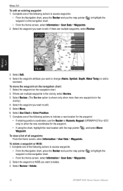
... want to edit.
To view a list of the following actions to indicate a new location for the waypoint:
• If entering position coordinates, use the Rocker or Numeric Keypad (GPSMAP 4210 ...the Home screen, select Information > User Data > Waypoints. 2. Complete one of the following actions to change (Name, Symbol, Depth, Water Temp) or add a comment.
To delete a waypoint or MOB:...
Owner's Manual - Page 39
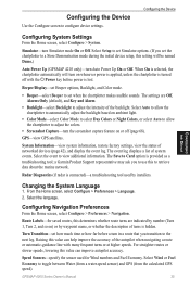
...Settings
From the Home screen, select Configure > System. When On is selected, the chartplotter automatically will be named Demo.)
Auto Power Up (GPSMAP 4210...to retrieve data about the marine network. Configuring Navigation Preferences
...Day Colors or Night Colors, or select Auto to allow the chartplotter to set Beeper options, Backlight, and Color mode.
• Beeper-select Beeper to adjust...
Owner's Manual - Page 40
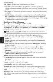
... chart that defines individual units of measure at the same time. Map Datum-set the coordinate system in which a given location reading appears. System Units-global setting that specifies a different position format.
36
GPSMAP 4000 Series Owner's Manual The default setting is structured. Changing this while navigating an automatic-guidance line will recalculate the path.
Do...
Owner's Manual - Page 41

... default settings. • Diagnostics-a tool used by installers to use when connecting your network. Preferred Sources-Assign a preferred device when more than one chartplotter on the network will perform this function for the chartplotter. Precision-adjust the number of digits (Two Digits, Three Digits, or Four Digits) to the right of the decimal point...
Owner's Manual - Page 42
... the system (GPS) clock.
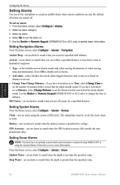
From the Home screen, select Configure > Alarms > Sonar. Configuring the Device
38
GPSMAP 4000 Series Owner's Manual
The chartplotter must have Activation set to Distance, select Change Distance to set the distance before arrival that the alarm should sound.
Select On to work. Use the Rocker or Numeric Keypad (GPSMAP 4210 or 4212...
Owner's Manual - Page 43
...for a keel.
Enter a positive number to offset for more information.
1. If the wheel turns freely, check the cable connections. sounds an alarm for calibration. Setting Weather Alarms
Note: You must...Support. GPSMAP 4000 Series Owner's Manual
39 Turn the following alarms on or off: marine, tornado, severe storm, flood, or flash flood. To enable the Total Fuel Onboard alarm and set the ...
Owner's Manual - Page 44

...•
Configuring the Device
40
GPSMAP 4000 Series Owner's Manual DSC-... positive number
shows depth at the surface. AIS-turn a safe zone around your changes...settings: 1. to 2.0 mi.).
• Select Time To (Safe Zone) to the water line (transducer installed on or off . Configuring the Device
To adjust the Keel Offset: 1. This shows the depth at the water line), enter a (+)
positive...
Owner's Manual - Page 46
... station can connect your GPSMAP 4000 series chartplotter to a Garmin Marine Network to receive data from and to Garmin chartplotters quickly and easily. All GSD 21 settings must be connected to the same chartplotter to the Garmin Marine Network and an appropriate transducer. Marine Network
Using the Marine Network
The Garmin Marine Network allows you to share...
Owner's Manual - Page 47
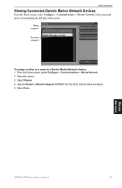
... the Rocker or Numeric Keypad (GPSMAP 4210 or 4212 only) to a Garmin Marine Network device: 1. Each connected device is listed along the left side of the screen.
Marine Network
GPSMAP 4000 Series Owner's Manual
43 From the Home screen, select Configure > Communications > Marine Network. 2. Select Done. Marine Network
Viewing Connected Garmin Marine Network Devices
From the Home screen...
Owner's Manual - Page 58
...positions of vessels sending position reports (page 56).
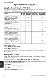
Select Configure > Other Vessels.
2. Use the Rocker or Numeric Keypad (GPSMAP 4210...routine call details to your chartplotter to the man-overboard point (page 55). If you initiate a man-overboard distress ...2.
Select Done. 4. Quickly set up and send individual routine ...GPS position to your chartplotter, the radio displays the Distress Call ...
Owner's Manual - Page 59
... you to activate navigation to the man-overboard point. Man-Overboard Distress Calls Initiated from a boat...position sent with the distress call. • Select Next Page or Previous Page to toggle between details related to a man-overboard location, see your radio is available and recorded with Radio to set a waypoint at least three seconds to view details about the call . GPSMAP...
Owner's Manual - Page 60

... can track vessels that sent the position report. To turn trails off for every vessel.
56
GPSMAP 4000 Series Owner's Manual
DSC Every position report call report. • Select...change the line color.
• Select Clear Report to delete the call received is also available with Radio to set the duration of position reports: 1.
For example, if you
select 4 Hours, all trail points...
Owner's Manual - Page 74
....
Flood Warning Alarm-(XM WX weather) there is outside the user-set value.
Invalid Date-an invalid date was entered. Invalid Entry.
MARPA: Dangerous Target-(radar) a MARPA target has become dangerous.
70
GPSMAP 4000 Series Owner's Manual Software Update Required-a GPS service software update is full, no more entries can be created. Low...
Installation Instructions - Page 7
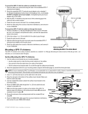
... set
Surface-mount bracket
Seal pad
screw ➌. Cable run through the pole mount and screw the assembled GPS 17 and pole-mount adapter onto the pole mount.
5. Position a standard 1 in the center of the GPS 17x
antenna, place the antenna on the pole mount, fill the remaining gap in . OD pipe-threaded-pole marine...
Installation Instructions - Page 8
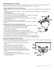
... M3 set screw ➌.
➋
6. (Optional) With the GPS 17x installed on the pole mount, fill the vertical cable slot with a marine sealant.
9. The GPS 17x will...GPS 17x, you want to mount the GPS 17x.
2. OD pipe-threaded-pole marine mount
(14 threads per inch-not included).
Connect the NMEA 2000 drop cable to the boat. Position a standard 1 in . OD pipe-threaded-pole marine...
Similar Questions

How Do I Go Into Simulation Mode On A Garmin Marine Gps Modle741xs
how do I use simulation mode on a garmin 741xs marine ver
how do I use simulation mode on a garmin 741xs marine ver
(Posted by Curthupp 6 years ago)

My Garmin Gpsmap 4210 Lost The Tracking Feature.
My garmin gpsmap 4210 lost tracking feature when my child played with buttons. How do I get it to tr...
My garmin gpsmap 4210 lost tracking feature when my child played with buttons. How do I get it to tr...
(Posted by Teah137 9 years ago)

How Do I Get The Temp Display On The Screen On My 4210 Garmin
(Posted by bndplumbing 10 years ago)
541s Marine Gps. Depth Not Reading Out.
Depth has been working since installed. Now blank. Is there an on off control for this that may have...
Depth has been working since installed. Now blank. Is there an on off control for this that may have...
(Posted by therad50 11 years ago)