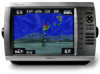
Garmin GPSMAP 4210 Support Question
Garmin GPSMAP 4210 Support Question
Find answers below for this question about Garmin GPSMAP 4210.Need a Garmin GPSMAP 4210 manual? We have 7 online manuals for this item!
Question posted by Teah137 on October 18th, 2014
My Garmin Gpsmap 4210 Lost The Tracking Feature.
My garmin gpsmap 4210 lost tracking feature when my child played with buttons. How do I get it to track again without losing my waypoints?
Current Answers
Related Garmin GPSMAP 4210 Manual Pages
Owner's Manual - Page 3
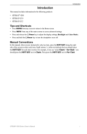
...and hold the Power key to turn the chartplotter on or off. Small arrows (>) in order. GPSMAP 4000 Series Owner's Manual For example, if you see "select Charts > Nav Chart," you ... that you should press the SOFT KEY for the following products:
• GPSMAP® 4208 • GPSMAP 4210 • GPSMAP 4212
Introduction
Tips and Shortcuts
• Press HOME from any screen to return...
Owner's Manual - Page 5
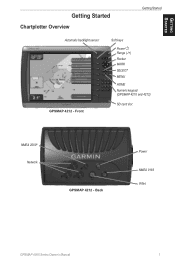
Front
Soft keys
Power Range (-/+) Rocker MARK SELECT MENU
HOME Numeric keypad (GPSMAP 4210 and 4212)
SD card slot
NMEA 2000® Network
GPSMAP 4212 - Back
Power NMEA 0183 Video
GPSMAP 4000 Series Owner's Manual
Getting Started
Getting Started
Chartplotter Overview
Getting Started
Automatic backlight sensor GPSMAP 4212 -
Owner's Manual - Page 8
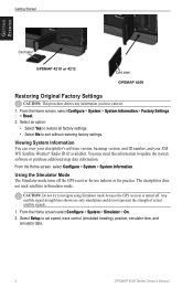
...GPSMAP 4000 Series Owner's Manual The chartplotter does not track satellites in Simulator mode.
Using the Simulator Mode The Simulator mode turns off . From the Home screen select Configure > System > Simulator > On. 2. Getting Started
Getting Started
Card label
GPSMAP 4210 or 4212
Card label GPSMAP... Simulator mode because the GPS receiver is turned off the GPS receiver for use indoors ...
Owner's Manual - Page 11
...features common to go.
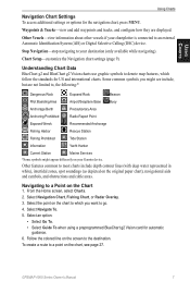
4. From the Home screen, select Charts. 2. Select the point on your Garmin device. Waypoints & Tracks-view and add waypoints and tracks, and configure how they are not limited to the destination. Navigating to a point on the Chart
1. GPSMAP... Prohibited
Tide Station
Information
Yacht Harbor
Current Station
Marine Services
*Some symbols might see page 27. Chart...
Owner's Manual - Page 28
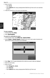
... automatic guidance.
6. Select an option: • Select Go To. • Select Guide To when using a preprogrammed BlueChart g2 Vision card.
24
GPSMAP 4000 Series Owner's Manual To stop navigating: 1.
Where To? Select the best location. 5. Use the Rocker or Numeric Keypad (GPSMAP 4210 or 4212 only) to the destination. Where To?
5.
Select Done.
Owner's Manual - Page 30
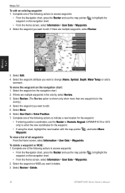
... add a comment. Complete one waypoint is shown only when more than one of all waypoints: From the Home screen, select Information > User Data > Waypoints. To view a list of the following actions to access waypoints:
• From the Navigation chart, press the Rocker and use the Rocker or Numeric Keypad (GPSMAP 4210 or 4212 only) to edit...
Owner's Manual - Page 35
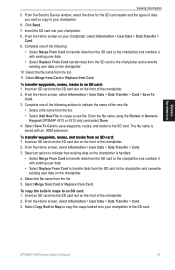
...overwrite existing user data on your chartplotter.
6. Select Save To Card to save waypoints, routes, and tracks to the chartplotter and combine it with an .ADM extension.
Insert the SD ...Select the file name from Card. Enter the file name using the Rocker or Numeric
Keypad (GPSMAP 4210 or 4212 only) and select Done. 4. Select an option to the chartplotter and overwrite existing ...
Owner's Manual - Page 36
... on those chartplotters.
• Select Merge User Data to transfer data between all waypoints, routes, and tracks: 1. From the Home screen on the card and paste it into the SD ...connected to a
computer. 6.
The DSC list can contain up data to a Garmin Marine Network using the Rocker or Numeric
Keypad (GPSMAP 4210 or 4212 only), and select Done. 4. From the Home screen, select Information ...
Owner's Manual - Page 39
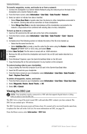
...Power Up (GPSMAP 4210 only)-turn on ) or by waypoint name, or whether the description of turns is turned off (page 68).
Simulator-turn the screenshot capture feature on ambient...tool; The settings are indicated by installers. a Garmin Product Support representative may ask you transition to retrieve data about the marine network. Configuring the Device
Configuring System Settings
From...
Owner's Manual - Page 42
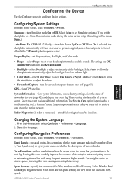
....
Clock-sets an alarm using the Garmin Marine Network to work.
Set to Off ...
Use the Rocker or Numeric Keypad (GPSMAP 4210 or 4212 only) to sound when ...To set an alarm to turn or destination waypoint.
• Type-select whether arrival alarms sound...GPS) clock. Anchor Drag-set an alarm: 1.
GPS Accuracy-sets an alarm to sound when the GPS location accuracy falls outside ...
Owner's Manual - Page 47
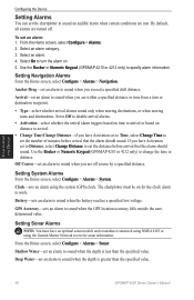
... assigned
No name assigned
To assign an alias or a name to name the device. 5. From the Home screen, select Configure > Communications > Marine Network. 2. Use the Rocker or Numeric Keypad (GPSMAP 4210 or 4212 only) to a Garmin Marine Network device: 1.
Select Done. Each connected device is listed along the left side of the screen. Select Review. 4.
Owner's Manual - Page 58
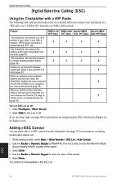
... the features that are using radar, see page 49 for information on or off .
NMEA 0183 VHF Radio
X
X
X
NMEA 2000 Garmin NMEA VHF Radio 0183 VHF Radio
X
X
X
X
X
X
Garmin NMEA 2000 VHF Radio
X X X X
X
X
To turn it on the Radar screen. Select DSC to initiate a man-overboard distress call .
1. Use the Rocker or Numeric Keypad (GPSMAP 4210...
Owner's Manual - Page 70

... to 131°F (-15°C to IEC 529-IPX-7
Temp. Appendix
Appendix
Specifications
Physical Specifications
Size: GPSMAP 4208: 7 in . H × 11¼ in . W × 4¾ in . W (131.4 × 174 mm)
GPSMAP 4210: 6⅜ in . H × 9⅝ in . (1 m)
GPS Performance Receiver: Differential-ready 12 parallel channel WAAS-capable receiver Acquisition Times:
Warm: 15 seconds...
Installation Instructions - Page 9

... look. Wiring the GPS 17 Antenna
The GPS 17 antenna must be necessary to drill holes to route the cable (power, NMEA 0183, NMEA
2000 Marine Video, or Marine Network.)
2. Note: If you want to route the connector end of these holes for extended runs of wire to cover these cables.
Garmin GPSMAP 4000/5000
Series...
Installation Instructions - Page 12

... chartplotters.
• All network components must all the connected Garmin chartplotters. The Garmin Marine Network Cable: • The Garmin Marine Network Cable has a locking ring that can connect a GPSMAP 4000/5000 chartplotter to a Marine Network with a GPSMAP 3000 series chartplotter: • They will share GPS 17 GPS position information as well as information to and from standard...
Installation Instructions - Page 13

... connections.
Note: These diagrams show the network connections; These diagrams show the Garmin Marine Network connections; Sample Garmin Marine Network Setups:
Garmin GPSMAP 4000/5000 series
chartplotter
Garmin GPSMAP 4000/5000 series
chartplotter
Marine Network with Two Chartplotters
Garmin marine radar
GDL 30/30A XM weather unit
xxxx
GSD 22 sounder unit
xxxxxxxxxxxxxxxxxxxxxxx...
Installation Instructions - Page 14
... existing Garmin Marine Network, the GMS 10 can be connected to the power supply for the boat. Wire each device according to either the existing GPSMAP 3000 series chartplotter or the new GPSMAP 4000/5000 Series chartplotter.
The GPSMAP 4000/5000 series chartplotter has three network ports and acts as a port expander. Wire the GPS antenna...
Installation Instructions - Page 15

... devices such as VHF radios, NMEA instruments, autopilots, or a computer.
Wiring Additional NMEA 0183 Devices
The NMEA 0183 data cable included with heat-shrink tubing.
Garmin GPSMAP 4000/5000 series
chartplotter
wire color
+
- Basic NMEA 0183 Wiring These diagrams illustrate basic NMEA 0183 wiring used to wire
various NMEA 0183-compliant devices...
Installation Instructions - Page 17

...
Black (data GND)
Black (data GND)
RX / A(+)
tX / A (+)
>
RX / B(-)
tX / B(-)
>
>
>
>
TX / A(+)
rX / A(+) >
>
TX / B(-)
rX / B(-) >
Wiring to a NMEA 0183-compliant Device With a Single Wire TX Connection
Garmin GPSMAP 4000/5000 series
unit
Power cable NMEA 0183 Cable
Wire see table for
Fuse
wire colors
7.5 A - 42 V Red (power)
+
-
Battery
10-35 Vdc
Wire Red...
Installation Instructions - Page 18

...35 Vdc
Horn
NMEA 0183 Cable
Yellow (alarm)
Wiring to function. Garmin GPSMAP 4000/5000 series
chartplotter
Power cable NMEA 0183 Cable
Wire see table for the GPSMAP 4000/5000 chartplotter to a lamp, a horn, or both , to... ma max coil current
Lamp
Wiring to a DB-9 PC Serial Connector
The GPSMAP 4008/4208/4010/4210/4012/4212/5008/5208/5012/5212 chartplotters can be used with a serial port...
Similar Questions

How Do I Go Into Simulation Mode On A Garmin Marine Gps Modle741xs
how do I use simulation mode on a garmin 741xs marine ver
how do I use simulation mode on a garmin 741xs marine ver
(Posted by Curthupp 6 years ago)


How Do I Get The Temp Display On The Screen On My 4210 Garmin
(Posted by bndplumbing 10 years ago)
541s Marine Gps. Depth Not Reading Out.
Depth has been working since installed. Now blank. Is there an on off control for this that may have...
Depth has been working since installed. Now blank. Is there an on off control for this that may have...
(Posted by therad50 11 years ago)