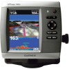
Garmin GPSMAP 546S Support Question
Garmin GPSMAP 546S Support Question
Find answers below for this question about Garmin GPSMAP 546S - Marine GPS Receiver.Need a Garmin GPSMAP 546S manual? We have 6 online manuals for this item!
Current Answers
Related Garmin GPSMAP 546S Manual Pages
Quick Reference Guide - Page 2

... chart ( ). Select Edit Route. To clear the active track: From any chart except the Fish Eye 3D, select MENU > Waypoints & Tracks > Tracks > On. the current track continues to... or left or right on the unit, the GPS receiver must collect satellite data and establish the current location.
Repeat this step to the route. From the Home screen, select Information > User Data > Routes > New...
Owner's Manual - Page 4
... Settings 6 Inserting and Removing SD Cards 6 Understanding the Home Screen 7
Using Charts 8 Using the Navigation Chart 8 Changing the Navigation Chart Settings 12 Using the Split Navigation Chart 15 Using Perspective 3D 15
ii
Using Mariner's Eye 3D 16 Using Fish Eye 3D 18 Using Fishing Charts 19 Enabling High Resolution Satellite Imagery 19 Viewing...
Owner's Manual - Page 5
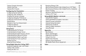
...Screen 59 Understanding the Temp Log Screen 59 Setting Up Sonar 60 Advanced Sonar Settings 61
Using Digital Selective Calling (DSC 63 Using the Chartplotter with a VHF Radio 63 Adding a DSC Contact 64 Viewing the DSC List 64
GPSMAP 400/500 Series Owner's Manual
Introduction
Receiving... 69 Viewing Forecast Information 72 Viewing Fishing Information 73 Viewing Sea Conditions 74 ...
Owner's Manual - Page 11
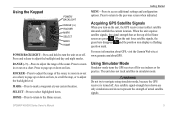
... to the previous screen when indicated. Press to zoom in or out on a chart, to page up or down on lists, to scroll the map, or to navigate using simulator mode, because the GPS receiver is turned off.
Press to return to adjust the backlight and day and night modes.
GPSMAP 400/500 Series...
Owner's Manual - Page 25

...or
both land and water.
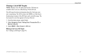
From the Home screen, select Charts > Fishing Chart. Using Fishing Charts
Use the Fishing chart for offshore deep-sea fishing. Enabling High Resolution Satellite Imagery
You can ...-resolution satellite images on the chart.
To access additional settings from the Fishing chart, press MENU. GPSMAP 400/500 Series Owner's Manual 19 Select Chart Setup > Photos.
...
Owner's Manual - Page 31

...screen, select Charts. 2.
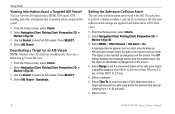
Select the length of the track that 3D chart view. Activating a Target for one chart or one 3D chart view are available only if you use a BlueChart g2 Vision SD card.
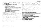
1. GPSMAP.... Select AIS Vessel > Activate Target. Select Navigation Chart, Fishing Chart, Perspective 3D, or Mariner's Eye 3D.
3. Activated target
Projected course
MMSI
Heading
Target...
Owner's Manual - Page 32
... are available only if you use a BlueChart g2 Vision SD card.
1. From the Home screen, select Charts.
2. From the Home screen, select Charts. 2. Using Charts
Viewing Information about a targeted AIS vessel.
1. Select Navigation Chart, Fishing Chart, Perspective 3D, or
Mariner's Eye 3D. 3. Select Time To to sound an alarm if AIS determines that is...
Owner's Manual - Page 33
... about all of AIS Targets Note: Mariner's Eye 3D charts and Fish Eye 3D charts are available only if you use a BlueChart g2 Vision SD card. From the Home screen, select Charts. 2. Making a Call... See "Calling an AIS Target" (page 67). GPSMAP 400/500 Series Owner's Manual
Using Charts 27 Select Navigation Chart, Fishing Chart, Perspective 3D, or
Mariner's Eye 3D. 3. The AIS list shows the MMSIs...
Owner's Manual - Page 42
... in each field.
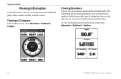
You can view up to access information about dashboard gauges, tides, currents, user data, and other vessels.
Viewing a Compass
From the Home screen, select Information > Dashboard > Compass. Viewing Numbers
You can customize the number of fields shown and the type of numerical information.
You can view and customize...
Owner's Manual - Page 60
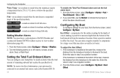
...and a connected Garmin XM WX weather receiver to sound when the unit detects a suspended target of a keel, making it possible to offset for large fish only. From the Home screen, select Configure > Alarms > Fuel... may draw several feet of the boat. From the Home screen, select Configure > My Boat > Keel Offset. GPSMAP 400/500 Series Owner's Manual Configuring the Chartplotter
Water Temp-...
Owner's Manual - Page 65
... MENU to set the duration and the scale for the log.
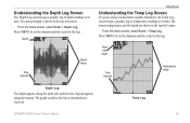
Temp Log
GPSMAP 400/500 Series Owner's Manual
59
Temp and depth
Time elapsed
Temperature range
...along the bottom. Depth
Time elapsed
Depth range
Using Sonar
Understanding the Temp Log Screen
If you are shown in the top-left as information is received. Press MENU to set the duration and the scale for the log. The ...
Owner's Manual - Page 91

...53 collision 26 deep water 53 fish 54 fuel 54 GPS accuracy 53 navigation 53 off course ...GPSMAP 400/500 Series Owner's Manual 85 Time 49 barometric pressure trend 49 Beeper/Display 48 BlueChart g2 Vision
using 34-38 bottom lock 61 buttons 5
C
Calibrate Water Speed 55 celestial information 43 Chart/Sonar screen
using 22 Chart Borders 14 chart data 10 charts
detail 13 fish eye 3D 18 fishing 19 mariner...
Owner's Manual - Page 92
...GPSMAP 400/500 Series Owner's Manual Index
Fish Symbols 18, 60 flasher 57 forecast information 72 frequency 61 Fuel Capacity 56 fuel gauges
synchronizing 40 viewing 40 full screen, sonar 57 Full Screen Map 9 fuse 78
G
gain 61 Garmin Data Transfer 51 go to 28 GPS 5, 48, 78 GPS... Zoom 61 map datum 49 MapSource data 44 Mariner's Eye 3D
AIS 27 MARPA 27 mariner's eye 3D colors 17 mark current location 30...
Owner's Manual - Page 4
... Settings 6 Inserting and Removing SD Cards 6 Understanding the Home Screen 7
Using Charts 8 Using the Navigation Chart 8 Changing the Navigation Chart Settings 12 Using the Split Navigation Chart 15 Using Perspective 3D 15
ii
Using Mariner's Eye 3D 16 Using Fish Eye 3D 18 Using Fishing Charts 19 Enabling High Resolution Satellite Imagery 19 Viewing...
Owner's Manual - Page 25
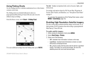
..., lights, and obstructions. To enable satellite imagery: 1. For settings and options related to Full Screen Map, Waypoints & Tracks, Other Vessels, and Data Bars, see "Navigation Chart Menu" on ...for a detailed, unobstructed view of the Fishing Chart screen, select MENU > Chart Setup (page 12).
While viewing the Navigation chart, press MENU. 2. GPSMAP 400/500 Series Owner's Manual
19 To...
Owner's Manual - Page 31
... view the AIS signal status, MMSI, GPS speed, GPS heading, and other information that appears using a trail, or turn the trail off. Activating a Target for an AIS Vessel Note: The Fishing chart and Mariner's Eye 3D are available with a preprogrammed BlueChart g2 Vision data card.
1. From the Home screen, select Charts. 2. Select AIS Vessel. Select...
Owner's Manual - Page 32
...Select a time. Select MENU > Other Vessels > AIS List.
26
GPSMAP 400/500 Series Owner's Manual Using Charts
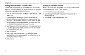
Setting the Safe-zone Collision Alarm...Fishing chart and Mariner's Eye 3D are applied to 24 minutes).
5. Viewing a List of the safe-zone ring to 2.0 mi.).
3. All safe-zone collision alarm settings are available with AIS. The safe zone is also labeled as dangerous on the screen...
Owner's Manual - Page 35
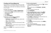
... the waypoint on the Navigation chart. To view a list of all waypoints: From the Home screen, select Information > User Data > Waypoints. Creating and Using Waypoints
You can store up to
...1.
Select the waypoint attribute you want to 1,500 waypoints (3,000 waypoints for models GPSMAP 431/441/531/541/536/546, including "s" models) with a user-defined name, symbol, depth, water temperature,...
Owner's Manual - Page 52
... on for large fish only.
46
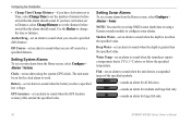
GPSMAP 400/500 Series ...the alarm should sound. Setting System Alarms To set a system alarm from the Home screen, select Configure > Alarms > Sonar. Clock-set an alarm to sound when you ...is less than the specified value.
Note: You must be receiving NMEA sonar depth data or using the system (GPS) clock. If you exceed a specified drift distance. Anchor...
Owner's Manual - Page 83
...clock 46 collision 26, 49 deep water 46 fish 46 fuel 47 GPS accuracy 46 navigation 45 safe-zone 49 shallow ...Calibrate Water Speed 48 Chart/Sonar screen
using 21 chart data 10 charts
detail 14 fish eye 3D 18 fishing 19 mariner's eye 3D 16 navigation 8 settings...iv
GPSMAP 400/500 Series Owner's Manual
course up 13 current stations 36 customizing chart settings 12
D
dashboard 34 Data Bars
fish eye...
Similar Questions

No Depth Readings On Gpsmap546s
Have cleaned pins on data cable, transducer, both hot wire and ground connection on data cable. Boug...
Have cleaned pins on data cable, transducer, both hot wire and ground connection on data cable. Boug...
(Posted by sue1953bc 7 years ago)

Direction Fish Are Moving
Have a striker 4. I fish shallow less than 10 ft trying to figure out which way the fish are moving,...
Have a striker 4. I fish shallow less than 10 ft trying to figure out which way the fish are moving,...
(Posted by Bob22259 7 years ago)


Cannot Update Software On 546s
Followed all the steps to load software update. I see it load and it reboots but then just hangs wit...
Followed all the steps to load software update. I see it load and it reboots but then just hangs wit...
(Posted by BAUERBK 11 years ago)

Fish Finder
I have sent this unit back and they sent me a new one? but still cant get ubit to locate fish, it is...
I have sent this unit back and they sent me a new one? but still cant get ubit to locate fish, it is...
(Posted by glipsky 13 years ago)