Garmin GPSMAP 546S Support Question
Garmin GPSMAP 546S Support Question
Find answers below for this question about Garmin GPSMAP 546S - Marine GPS Receiver.Need a Garmin GPSMAP 546S manual? We have 6 online manuals for this item!
Question posted by BAUERBK on May 20th, 2012
Cannot Update Software On 546s
Followed all the steps to load software update. I see it load and it reboots but then just hangs with the word GARMIN on the screen. I never get the I AGREE. I am going from 3.10 to the latest ver
Current Answers
Related Garmin GPSMAP 546S Manual Pages
Installation Instructions - Page 10

...lb. (800 g)
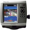
Display: GPSMAP 420/421/430/431/440/441/450/451 (s): 4.0 in . GPSMAP 526/536/546/556 (s): High-sensitivity 12 parallel channel WAAS-capable receiver. Update Rate: 1/second, continuous
GPS Accuracy: Position: Return the ...for a stationary receiver with adjustable brightness, 640 × 480 pixels, capable of the boat and put the transducer at a slow speed. diagonal (10.6 cm), QVGA ...
Installation Instructions - Page 11
...Update COG/SOG Rapid Update GNSS - Route/WP information GNSS DOPs GNSS Sats in View Wind Data
Compatible GPSMAP 400/500 series chartplotters are supported by the GPSMAP 525s/526s/535s/536s/545s/546s... Group Function Transmit/Receive PGN List Group Function...Marine Electronics Association (NMEA) format and sentences from: NMEA Seven Riggs Avenue Severna Park, MD 21146 USA www.nmea.org
GPSMAP...
Owner's Manual - Page 4
...Registration iv Contact Garmin iv
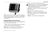
Getting Started 1 Unit Overview 1 Turning the Unit On or Off 2 Initializing Unit Settings 3 Adjusting the Backlight 4 Using the Keypad 5 Acquiring GPS Satellite Signals ...Home Screen 7
Using Charts 8 Using the Navigation Chart 8 Changing the Navigation Chart Settings 12 Using the Split Navigation Chart 15 Using Perspective 3D 15
ii
Using Mariner's ...
Owner's Manual - Page 13
... MapSource or HomePort by clicking Help > Check for Software Updates, or check the Garmin Web site at www.garmin.com. Getting Started
• Where To?-access navigation features (page 28). • Information-view information including dashboard options,
tides, currents, celestial data, user data, and information about other screens.
GPSMAP 400/500 Series Owner's Manual
Note: You...
Owner's Manual - Page 32
...Alarm The safe-zone collision alarm can view the AIS signal status, MMSI, GPS speed, GPS heading, and other information that a target will intersect the safe zone within the..., Perspective 3D, or
Mariner's Eye 3D. 3. Select a distance.
6. From the Home screen, select Charts. 2. The safe zone is reported about a targeted AIS vessel.
1.
Select a time.
26
GPSMAP 400/500 Series Owner's...
Owner's Manual - Page 41

... sea floor according to detailed marine charting, BlueChart g2 Vision has the following features:
• Mariner's Eye 3D-provides a view from static electricity. Navigating with NMEA 2000 compatible chartplotters (GPSMAP 441/441s, GPSMAP 536/536s, GPSMAP 541/541s, and GPSMAP 546/546s). In addition to the information on BlueChart g2 Vision-compatible Garmin GPS units and when using HomePort...
Owner's Manual - Page 60
...to XM WX Weather and a connected Garmin XM WX weather receiver to view weather information (page 68).... value in step 3 as the Garmin GFS 10.
54
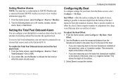
To enable the Total Fuel Onboard alarm and set the fuel alarm level: 1. GPSMAP 400/500 Series...feet of water. Turn the following alarms on or off: marine, tornado, severe
storm, flood, or flash flood.
From the Home screen, select Configure > My Boat...
Owner's Manual - Page 65
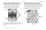
... in the top-left as information is shown in the top-left corner.
Temp Log
GPSMAP 400/500 Series Owner's Manual
59
The current temperature and the depth are using a temperature-capable transducer, the Temp Log screen keeps a graphic log of depth readings over time. The graph scrolls to set the duration...
Owner's Manual - Page 75
... 3D chart or a Mariner's Eye 3D chart:
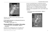
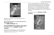
Press MENU > Weather Radar > On. If Weather is shown independently or with a variety of the screen indicates the elapsed time since the National Weather Service last updated the information. To view weather information on the chart. NEXRAD shows very light rain and
GPSMAP 400/500 Series Owner...
Owner's Manual - Page 84
... Times: (Average acquisition times for a stationary receiver with a clear view of the sky) GPSMAP 431/431s GPSMAP 441/441s GPSMAP 531/531s GPSMAP 541/541s
Warm:* Approximately 1 second Cold:** Approximately 38 seconds
GPSMAP 536/536s GPSMAP 546/546s
Warm:* Approximately 15 seconds Cold:** Approximately 38 ...turned off, or it has been turned off for more than 2 weeks.
GPS Accuracy: Position:
Owner's Manual - Page 91

... Speed 55 celestial information 43 Chart/Sonar screen
using 22 Chart Borders 14 chart data 10 charts
detail 13 fish eye 3D 18 fishing 19 mariner's eye 3D 16 navigation 8 settings 12...53 battery 53 clock 53 collision 26 deep water 53 fish 54 fuel 54 GPS accuracy 53 navigation 53 off course 53 shallow water 53 sonar 53 water temp... 27 fishing information 73
GPSMAP 400/500 Series Owner's Manual 85
Owner's Manual - Page 92
...GPSMAP 400/500 Series Owner's Manual Index
Fish Symbols 18, 60 flasher 57 forecast information 72 frequency 61 Fuel Capacity 56 fuel gauges
synchronizing 40 viewing 40 full screen, sonar 57 Full Screen Map 9 fuse 78
G
gain 61 Garmin Data Transfer 51 go to 28 GPS 5, 48, 78 GPS...MapSource data 44 Mariner's Eye 3D
AIS 27 MARPA 27 mariner's eye 3D ...
customizing 37 overlay numbers 10 viewing 36
O
object ...
Owner's Manual - Page 4
...Registration iv Contact Garmin iv
Getting Started 1 Unit Overview 1 Turning the Unit On or Off 3 Initializing Unit Settings 3 Adjusting the Backlight 4 Using the Keypad 5 Acquiring GPS Satellite Signals ...Home Screen 7
Using Charts 8 Using the Navigation Chart 8 Changing the Navigation Chart Settings 12 Using the Split Navigation Chart 15 Using Perspective 3D 15
ii
Using Mariner's ...
Owner's Manual - Page 12
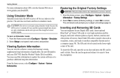
From the Home screen select Configure > System > Simulator. 2.
Viewing System Information
You can view the software version, the basemap version, supplemental map information (if applicable), the unit ID number, and your XM® WX Satellite Weather® Radio ID (if available).
Using Simulator Mode
Simulator mode turns the GPS receiver off . The unit reboots and prompts...
Owner's Manual - Page 13
...Software Updates, or check the Garmin Web site at www.garmin.com.
Note: You must have an "s" series unit (such as a GPSMAP 441s) with a connected transducer or have a connection to a Garmin sounder via CANet to use a BlueChart g2 Vision SD card. GPSMAP 400/500 Series Owner's Manual
7 Note: Mariner... about other screens. Understanding the Home Screen
Use the Home screen to access ...
Owner's Manual - Page 31
... The Fishing chart and Mariner's Eye 3D are available with a preprogrammed BlueChart g2 Vision data card.
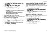
1. Use the Rocker to select an AIS vessel. 4. GPSMAP 400/500 Series Owner's ..., GPS speed, GPS heading, and other information that appears using a trail, or turn the trail off.
From the Home screen, select Charts. 2. Select Navigation Chart, Fishing Chart, Perspective 3D, or
Mariner's Eye...
Owner's Manual - Page 53
...Garmin GFS 10.
From the Home screen, select Configure > Alarms > Fuel >
Total Onboard > On (or Off). 2. To adjust the Keel Offset: 1. From the Home screen...and a connected Garmin XM WX weather receiver to the water line (transducer installed on or off: marine, tornado, severe...information (page 60).
1.
GPSMAP 400/500 Series Owner's Manual
47 Turn the following alarms on the bottom of ...
Owner's Manual - Page 66

... mode does not provide live weather data. Using XM WX Weather
The Garmin XM receiver and antenna receives XM WX weather data and shows it can change in Simulator mode. Visit http://www8.garmin.com/xm/ for your chartplotter's Navigation chart and other screens throughout the chartplotter. Using XM WX Weather and Audio
Using XM...
Owner's Manual - Page 67
...GPSMAP 400/500 Series Owner's Manual
61 NEXRAD is set to strong thunderstorms in the upper-left corner of the screen indicates the elapsed time since the National Weather Service last updated the information.
From the Home screen... 3D chart or a Mariner's Eye 3D chart:
Press MENU > Weather Radar > On. You can view NEXRAD information as an image of the latest update, or as an animated...
Owner's Manual - Page 82
... property of Garmin. Hardware and required monthly subscription sold separately. Under 10 U.S.C. 456, no warranty, express or implied, including, but not limited to the accuracy and functioning of the National Geospatial-Intelligence Agency.
76
Software License Agreement
BY USING THE UNIT, YOU AGREE TO BE BOUND BY THE TERMS AND CONDITIONS OF THE FOLLOWING SOFTWARE LICENSE...
Similar Questions

What Is Error Code 1 On Garmin Radome Radar?
(Posted by ultraypm 11 months ago)

Mgr 18 Hd
i hane a message on m'y GPS : code error 1.what is the problem?
i hane a message on m'y GPS : code error 1.what is the problem?
(Posted by Anonymous-161629 7 years ago)

My Gps Won't Power Up
my gps won't power up,and when it did it just showed the screen garmin then shut off
my gps won't power up,and when it did it just showed the screen garmin then shut off
(Posted by harlequin687 7 years ago)


How Do I View Time On The 546s
(Posted by wbherbert 12 years ago)