Garmin GPSMAP 540s - Marine GPS Receiver Support and Manuals
Get Help and Manuals for this Garmin item
View All Support Options Below
Free Garmin GPSMAP 540s manuals!
Problems with Garmin GPSMAP 540s?
Ask a Question
Free Garmin GPSMAP 540s manuals!
Problems with Garmin GPSMAP 540s?
Ask a Question
Most Recent Garmin GPSMAP 540s Questions

Flashing Depth Indicator
The debth indicator on my GPS/500 series flashes a debt that is not accurate. It appears to be stuck...
The debth indicator on my GPS/500 series flashes a debt that is not accurate. It appears to be stuck...
(Posted by tim47299 10 years ago)

Flashing Question Mark
There is a constant flashing question mark appearing on the boat symbol. What does that mean?
There is a constant flashing question mark appearing on the boat symbol. What does that mean?
(Posted by oillaw 10 years ago)


Fish Finder
I have sent this unit back and they sent me a new one? but still cant get ubit to locate fish, it is...
I have sent this unit back and they sent me a new one? but still cant get ubit to locate fish, it is...
(Posted by glipsky 13 years ago)
Popular Garmin GPSMAP 540s Manual Pages
Owner's Manual - Page 2

...2000® and the NMEA 2000 logo are trademarks of the National Maritime Electronics Association.
or its subsidiaries. Garmin®, the Garmin logo, GPSMAP®, AutoLocate®, BlueChart®, g2 Vision®, and MapSource® are registered trademarks of Garmin Ltd. Ultrascroll™, myGarmin™, and GFS™ are registered trademarks of Microsoft Corporation in the...
Owner's Manual - Page 4
... Using Routes 30 Using Tracks 31 Using BlueChart g2 Vision 33 Navigating with a Garmin Autopilot 33
Viewing Information 34 Viewing a Compass 34 Viewing Numbers 34 Viewing Trip Information 35 Viewing Fuel Gauges 35 Viewing Tide-station Information 36 Viewing Current Information 36 Viewing User Data 37 Viewing Other Vessels 40
GPSMAP 400/500 Series Owner's Manual
Owner's Manual - Page 12
...® WX Satellite Weather® Radio ID (if available). Insert optional BlueChart® g2 Vision® SD cards to eject it clicks.
You may need this information to update the system software or to another compatible Garmin unit or a computer (page 38).
Insert blank SD cards to transfer data such as waypoints, routes, and tracks to purchase...
Owner's Manual - Page 13

... 3D, and Split Navigation charts. Note: If using an SD card to transfer waypoints from any screen to return to the most-current version of MapSource by clicking Help > Check for Software Updates, or check the Garmin Web site at www.garmin.com. Understanding the Home Screen
Use the Home screen to use a BlueChart g2 Vision SD card.
Owner's Manual - Page 16
....
10
GPSMAP 400/500 Series Owner's Manual Using Charts...Setup-customize the Navigation chart settings (page 12).
Understanding Chart Data BlueChart g2 and BlueChart g2 Vision charts use graphic symbols to go. 4. Select Wind to provide a graphical representation of the screen to toggle between displaying Wind Velocity Made Good (VMG) and Waypoint VMG in the Data Bars The chartplotter...
Owner's Manual - Page 18

...GPSMAP 400/500 Series Owner's Manual Photos-sets the high-resolution satellite images to highlight a tide-station icon ( ), and press SELECT. Changing the Navigation Chart Settings
To change chart settings from the home screen, select Charts > Navigation Chart > MENU > Chart Setup...while using a BlueChart g2 Vision SD card. You can view an in the area, select Review, and then select the ...
Owner's Manual - Page 20
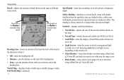
...-turns spot soundings on or off . • Distance-sets the distance to see what area the maps cover. • Photo Points-turns camera icons (page 21) on the Rocker to increase map detail. GPSMAP 400/500 Series Owner's Manual
Press left on or off when using a BlueChart g2 Vision SD card. Heading Line-draws an extension line from...
Owner's Manual - Page 22
... provides a visual navigation aid.
This setting also affects routes (Route To), but does not affect automatic guidance (Guide To).
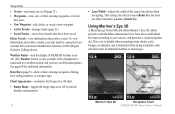
This view is helpful when navigating tricky shoals, reefs, bridges, or channels, and is connected to a weather module and you have been saved. Using Mariner's Eye 3D
A BlueChart g2 Vision SD card offers Mariner's Eye 3D, which...
Owner's Manual - Page 24
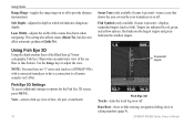
This setting also affects routes (Route To), but does not affect automatic guidance (Guide To). Fish Symbols (only available if sonar is present)-turns a cone that shows the area covered by red, green, and yellow spheres. Using Fish Eye 3D
Using the depth contour lines of the BlueChart g2 Vision cartography, Fish Eye 3D provides an underwater...
Owner's Manual - Page 25
... the Navigation chart when using a preprogrammed BlueChart g2 Vision SD card.
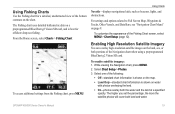
Select Chart Setup > Photos. 3. The higher you set the percentage, the more the satellite photos will cover both the water and the land at a specified
opacity.
Select one of the bottom contours on the chart. GPSMAP 400/500 Series Owner's Manual 19
Using Fishing Charts
Use the Fishing...
Owner's Manual - Page 26
... (page 14).
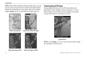
GPSMAP 400/500 Series Owner's Manual If you cannot see the high-resolution images in your surroundings or to acquaint yourself with a marina or a harbor prior to your BlueChart g2 Vision region, either zoom in and out while viewing the aerial photo on the full screen. Viewing Aerial Photos
Preprogrammed BlueChart g2 Vision SD cards contain aerial...
Owner's Manual - Page 27

... Aerial Photo or Review.
GPSMAP 400/500 Series Owner's Manual
21 Select Review or the name of interest (POI) data, which includes highly detailed coastal roads and POIs such as highlighted arrows. For instructions on setting up Automatic Guidance for , and navigating to, these POIs, see the "Where To?" section beginning on available BlueChart g2 Vision chart information. To...
Owner's Manual - Page 33
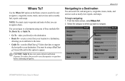
... , waypoints, routes, tracks, and services such as nearby fuel, repairs, and ramps. You must create waypoints and routes before continuing navigation. From the Home screen, select Where To?. 2.
Where To?
Use the Where To? GPSMAP 400/500 Series Owner's Manual
27
Navigating to a Destination
You can navigate to a destination using a BlueChart g2 Vision SD card for , and navigate...
Owner's Manual - Page 42

...BlueChart g2 Vision card to view Tidestation information.
36
GPSMAP 400/500 Series Owner's Manual...BlueChart g2 Vision card to view information for currents. Select Change Date > Manual to view the Tide Prediction Report for the selected station.
Adjust if necessary. • Set Total Fuel Onboard-select to an external fuel sensor, such as the Garmin... Economy-select either GPS Speed or Water...
Owner's Manual - Page 83

...BlueChart g2 Vision
using 33-37 bottom lock 54 buttons 5
C
Calibrate Water Speed 48 Chart/Sonar screen
using 21 chart data 10 charts
detail 14 fish eye 3D 18 fishing 19 mariner's eye 3D 16 navigation 8 settings... Garmin Data Transfer 44 gauges, fuel 35 go to 27 GPS 5, 41, 70 Grid (North) 42 guide to 27
H
Hazard Colors 17 heading 42 Heading Line 14 Head Up 13
GPSMAP 400/500 Series Owner's Manual 77
Garmin GPSMAP 540s Reviews
We have not received any reviews for Garmin yet.