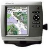
Garmin GPSMAP 540s Support Question
Garmin GPSMAP 540s Support Question
Find answers below for this question about Garmin GPSMAP 540s - Marine GPS Receiver.Need a Garmin GPSMAP 540s manual? We have 4 online manuals for this item!
Question posted by tim47299 on July 29th, 2013
Flashing Depth Indicator
The debth indicator on my GPS/500 series flashes a debt that is not accurate. It appears to be stuck on one setting then flashes another depth for a while.
Current Answers
Related Garmin GPSMAP 540s Manual Pages
Flush Mount Kit Instructions (multilingual) - Page 1
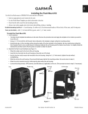
... the unit housing.
• Connect the wiring harness, GPS antenna, and XM antenna (if applicable) to the unit...jig saw , cut the mounting surface along the inside the indicated line and then sand or file the panel as needed to mount ...EN
Installing the Flush Mount Kit
Use this kit to flush mount a GPSMAP 500 series unit into a flat panel.
• Select an appropriately sized location for...
Quick Reference Guide - Page 1

... change (Name, Symbol, Depth, Water Temp,
Comment, or Position). Select Review. (The Review button is only shown when more than one waypoint is in the vicinity.)
GPSMAP® 400/500 series
quick reference guide From the Home screen, select Information > User Data > Waypoints. 2. To delete a waypoint or an MOB: 1. Finding a Marine Service and Navigating to...
Owner's Manual - Page 3
... from any of items on the screen using the Rocker, and press the SELECT key after each item.
GPSMAP 400/500 Series Owner's Manual They indicate that you should highlight a series of the main screens to access advanced settings.
• Press and release the Power key to a Destination: page 27 • Creating and Using Waypoints: page...
Owner's Manual - Page 4
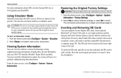
...GPS Satellite Signals 5 Using Simulator Mode 6 Viewing System Information 6 Restoring the Original Factory Settings 6 Inserting and Removing SD Cards 6 Understanding the Home Screen 7
Using Charts 8 Using the Navigation Chart 8 Changing the Navigation Chart Settings 12 Using the Split Navigation Chart 15 Using Perspective 3D 15
ii
Using Mariner... 40
GPSMAP 400/500 Series Owner's Manual
Owner's Manual - Page 11
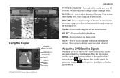
...loses satellite signals, the green bars disappear and the position icon displays a flashing question mark. GPSMAP 400/500 Series Owner's Manual RANGE (-/+)-Press to adjust the range of the Home screen... turn on the unit, the GPS receiver must collect satellite data and establish the current location. Press and release to access additional settings and configuration options. MENU-Press to...
Owner's Manual - Page 12
... from the chartplotter.
GPSMAP 400/500 Series Owner's Manual Using Simulator Mode
Simulator mode turns the GPS receiver off . To turn on...set speed, track control, and position. Getting Started
For more information about GPS, visit the Garmin Web site at www.garmin.com/aboutGPS. Select Yes to restore all factory settings, or select No to navigate using simulator mode because the GPS receiver...
Owner's Manual - Page 14

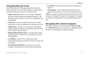
...-displays all relevant navigation data available on your preloaded maps, including buoys, lights, cables, depth soundings, marinas, and tide stations, in an overhead view.
• Perspective 3D-provides ...-displays two different zoom levels of the chart with g2 Vision GPSMAP 400/500 Series Owner's Manual The BlueChart g2 Vision Mariner's Eye 3D is more detailed than the preloaded data. Using ...
Owner's Manual - Page 15

...navigation, fishing, fuel, or sailing numbers. Navigation Chart Menu To access additional settings or options for the Navigation chart, press MENU. Select Data Bar Setup to... the Navigation or Fishing chart in fullscreen mode, without numbers.
GPSMAP 400/500 Series Owner's Manual
Using Charts
Data bars
• Cruising-turn the Depth, Water Temperature, and Water Speed data bar on or off....
Owner's Manual - Page 18

....
Viewing Tide-Station Information Tide-station information appears on the chart with the map pointer,
... your boat, indicating compass direction.
Selected item
2. For more than one item is in -depth graph for a...marine wind sensor.
12
GPSMAP 400/500 Series Owner's Manual
If more information about on or off .
Changing the Navigation Chart Settings
To change chart settings...
Owner's Manual - Page 23

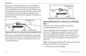
... land as beacons, lights, and obstructions: 1. When the cursor is very shallow water.
The On setting indicates shallow water and land with a color scale. To customize the appearance of the screen.
Mariner's Eye 3D (Water Hazard Colors) GPSMAP 400/500 Series Owner's Manual 17 Press the Range (+) key to move the view away from the boat.
To...
Owner's Manual - Page 30
... active transponder signals from other vessels appear on a chart or on a 3D...
The details, projected heading, and trails settings configured for one chart or one 3D chart...projected course of turn information, is indicated by an activated AIS target, the...Mariner's Eye 3D are applied only to that chart or to all 3D chart views. From the Home screen, select Charts.
24
GPSMAP 400/500 Series...
Owner's Manual - Page 31
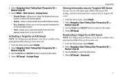
... vessel. 4. Select Navigation Chart, Fishing Chart, Perspective 3D, or
Mariner's Eye 3D. 3. Using Charts
Viewing Information about a Targeted AIS Vessel You can view the AIS signal status, MMSI, GPS speed, GPS heading, and other information that appears using a trail, or turn the trail off. GPSMAP 400/500 Series Owner's Manual
25 Use the Rocker and SELECT button...
Owner's Manual - Page 39
GPSMAP 400/500 Series Owner's Manual
33 In addition to detailed marine charting, BlueChart g2 Vision has the following features:
• Mariner's Eye 3D-provides a view from the SD ...; Auto Guidance-uses the chart data and specified boat safe depth to determine the best course to your destination (page 43). The BlueChart g2 Vision Mariner's Eye 3D is more detailed than the preloaded data.
&#...
Owner's Manual - Page 40

.... You can view and customize numerical data including depth, GPS information, and navigation information. To view the Numbers screen from the Home screen, select Information > Dashboard > Numbers.
Viewing a Compass
From the Home screen, select Information > Dashboard > Compass.
Press MENU and select Configure.
34
GPSMAP 400/500 Series Owner's Manual You can customize the number of...
Owner's Manual - Page 49

... Chartplotter
using automatic guidance.
• Safe Height-set the minimum depth (chart depth datum) to allow when calculating an automatic guidance path. Select Navigate To > Guide To.
6. Proceed to step 9.
• If the Auto Guidance line is satisfactory, select MENU > Navigation Options > Stop Navigation. GPSMAP 400/500 Series Owner's Manual
43 From Home screen, select Where...
Owner's Manual - Page 52

... unit must be on for large fish only.
46
GPSMAP 400/500 Series Owner's Manual
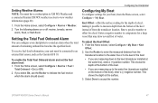
Off Course-set an alarm to sound when you exceed a specified drift distance. GPS Accuracy-set an alarm to sound when the depth is 2°F (1.1°C) above or below the specified temperature.
Fish-set an alarm to sound when the battery reaches a specified...
Owner's Manual - Page 53
... receiver to the water line (transducer installed on or off: marine, tornado, severe
storm, flood, or flash flood.
Setting Weather Alarms Note: You must be connected to an external fuel sensor, such as the Garmin GFS 10.
Use the Rocker to enter the measured distance from the Home screen, select Configure > My Boat. GPSMAP 400/500 Series...
Owner's Manual - Page 61
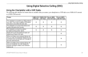
...distress call. If your radio is capable, GPS position information is transmitted with a VHF Radio
The following table indicates the features that are available when you ... receive DSC distress and position information from the radio. NMEA 0183 NMEA 2000 Garmin NMEA Garmin NMEA VHF Radio VHF Radio 0183 VHF Radio 2000 VHF Radio
X
X
X
X
X
X
X
X
X
X
X
X
X
X
X
GPSMAP 400/500 Series ...
Owner's Manual - Page 69
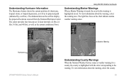
... about the warning, select the warning area. The darkened dots on the chart indicate marine weather warning zones.
GPSMAP 400/500 Series Owner's Manual 63 The light blue lines on the red line display the projected locations received from the National Hurricane Center.
Marine Warning
Hurricane
Understanding County Warnings When the National Weather Service issues a weather warning...
Owner's Manual - Page 83

...GPS accuracy 46 navigation 45 safe-zone 49 shallow water 46 sonar 46 water temp 46 weather 47 Appearance... 3D 18 fishing 19 mariner's eye 3D 16 navigation 8 settings 12 cleaning the unit ...Conformity iv delete a waypoint 30 depth line 52 depth waypoint 53 Detail, chart 14 ...GPS 5, 41, 70 Grid (North) 42 guide to 27
H
Hazard Colors 17 heading 42 Heading Line 14 Head Up 13
GPSMAP 400/500 Series Owner's ...
Similar Questions

How Do I Go Into Simulation Mode On A Garmin Marine Gps Modle741xs
how do I use simulation mode on a garmin 741xs marine ver
how do I use simulation mode on a garmin 741xs marine ver
(Posted by Curthupp 7 years ago)

Flashing Depth
My Garmin Striker 4dv will show depth and then freeze on that depth and start flashing for quite som...
My Garmin Striker 4dv will show depth and then freeze on that depth and start flashing for quite som...
(Posted by kenlawtonokc 7 years ago)

Flashing Question Mark
There is a constant flashing question mark appearing on the boat symbol. What does that mean?
There is a constant flashing question mark appearing on the boat symbol. What does that mean?
(Posted by oillaw 10 years ago)

541s Marine Gps. Depth Not Reading Out.
Depth has been working since installed. Now blank. Is there an on off control for this that may have...
Depth has been working since installed. Now blank. Is there an on off control for this that may have...
(Posted by therad50 11 years ago)

Fish Finder
I have sent this unit back and they sent me a new one? but still cant get ubit to locate fish, it is...
I have sent this unit back and they sent me a new one? but still cant get ubit to locate fish, it is...
(Posted by glipsky 13 years ago)