Garmin GPSMAP 546S Support Question
Garmin GPSMAP 546S Support Question
Find answers below for this question about Garmin GPSMAP 546S - Marine GPS Receiver.Need a Garmin GPSMAP 546S manual? We have 6 online manuals for this item!
Current Answers
Answer #1: Posted by TommyKervz on July 13th, 2016 5:11 AM
TommyKervz

Member since:
January 10th, 2013 Points: 17,776,823

Member since:
January 10th, 2013 Points: 17,776,823
See the troubleshooting guide here http://www.boatus.com/magazine/archives/troubleshooting-fish-finders.asp
Related Garmin GPSMAP 546S Manual Pages
Installation Instructions - Page 8
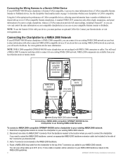
...a CANet connection provides full sonar readings, including Ultrascroll™, so you can use the... NMEA 0183 connection only allows depth, temperature, and speed information ...local Garmin dealer or marine dealer. NOTE: NMEA 2000-compatible GPSMAP 400/500 series ... you can receive sonar information from your compatible Garmin sounder or fishfinder. NMEA 2000compatible GPSMAP 400/500 ...
Installation Instructions - Page 9
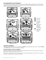
... that were added below to configure your chartplotter. You cannot get a depth or distance reading when the transducer is necessary to carry the sonar signal from the sounder...10124; External GPS
antenna (sold separately)
➍ Compatible XM
antenna with audio adapter (sold separately)
➎ Compatible XM
antenna (sold separately)
GPSMAP 521, 541, 551
GPSMAP 526, 536, 546, and 556
...
Installation Instructions - Page 10

Begin testing the installation at which the signal was turned off. Caution: When adjusting the depth of the sonar.
GPSMAP 526/536/546/556 (s): High-sensitivity 12 parallel channel WAAS-capable receiver.
Update Rate: 1/second, continuous
GPS Accuracy: Position:
Specifications
Physical Specifications Size : 400 Series: W × H × D: 5.7 × 5.0 . × 3.0 in.
(14.5 ...
Installation Instructions - Page 11
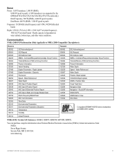
... information GNSS DOPs GNSS Sats in View Wind Data
Compatible GPSMAP 400/500 series chartplotters are supported by the GPSMAP 525s/526s/535s/536s/545s/546s/555s/556s units only.) Dual Frequency, 500 W (RMS), 4,000 W (peak to peak);
Command/Request/Acknowledge Group Function Transmit/Receive PGN List Group Function Product Information Vessel Heading Engine...
Owner's Manual - Page 4
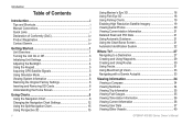
...On or Off 2 Initializing Unit Settings 3 Adjusting the Backlight 4 Using the Keypad 5 Acquiring GPS Satellite Signals 5 Using Simulator Mode 5 Viewing System Information 6 Restoring the Original Factory Settings 6 ...12 Using the Split Navigation Chart 15 Using Perspective 3D 15
ii
Using Mariner's Eye 3D 16 Using Fish Eye 3D 18 Using Fishing Charts 19...GPSMAP 400/500 Series Owner's Manual
Owner's Manual - Page 32
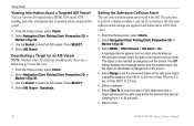
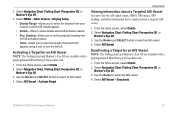
...zone is reported about a targeted AIS vessel.
1. Select a distance.
6. Select a time.
26
GPSMAP 400/500 Series Owner's Manual Use the Rocker to select an AIS vessel.
Use the Rocker to select... 3D, or
Mariner's Eye 3D. 3. Press SELECT. 4. Setting the Safe-zone Collision Alarm The safe-zone collision alarm can view the AIS signal status, MMSI, GPS speed, GPS heading, and ...
Owner's Manual - Page 41

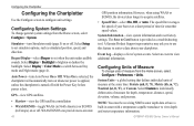
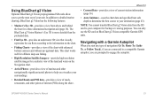
...GPS units and when using HomePort. Navigating with NMEA 2000 compatible chartplotters (GPSMAP 441/441s, GPSMAP 536/536s, GPSMAP 541/541s, and GPSMAP 546/546s).
GPSMAP... Auto Guidance-uses the chart data and specified boat safe depth to determine the best course to get the most out of... data from static electricity.
The BlueChart g2 Vision Mariner's Eye 3D is installed on your PC. Optional...
Owner's Manual - Page 54
... more-accurate
48
GPS position information.
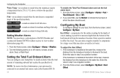
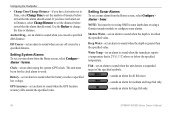
Select an event to switch between Day mode and Night mode (page 4).
GPS-view GPS satellites.
• Skyview-view the GPS satellite constellation •... speed of measure for smoother speed values. Note: You must be receiving NMEA sonar depth data or have a built-in Europe) on whenever power is applied...GPSMAP 400/500 Series Owner's Manual
Owner's Manual - Page 59
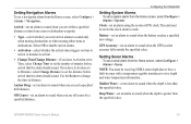
...receiving NMEA sonar depth data or have Activation set to Time, select Change Time to set an alarm to sound when the depth... is less than the specified value. Shallow Water-set an alarm to sound when the depth is greater than the specified value. GPSMAP... time from the Home screen, select Configure > Alarms > System. GPS Accuracy-set a system alarm from a turn or destination waypoint.
&#...
Owner's Manual - Page 60
...GPSMAP 400/500 Series Owner's Manual Turn the following alarms on or off: marine, tornado, severe
storm, flood, or flash flood.
Keel Offset-compensates for the surface reading...sounds an alarm for the depth of a keel, making it possible to measure depth from the bottom of the... to XM WX Weather and a connected Garmin XM WX weather receiver to view weather information (page 68).
1. If the transducer...
Owner's Manual - Page 65
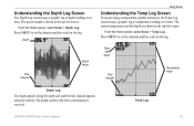
..., and the time elapsed appears along the bottom.
Temp Log
GPSMAP 400/500 Series Owner's Manual
59 The present depth is received. From the Home screen, select Sonar > Temp Log.
Understanding the Depth Log Screen
The Depth Log screen keeps a graphic log of temperature readings over time. Press MENU to the left as information is shown...
Owner's Manual - Page 84
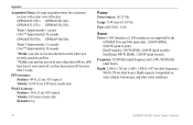
GPS Accuracy: Position: Appendix
Acquisition Times: (Average acquisition times for a stationary receiver with a clear view of the sky) GPSMAP 431/431s GPSMAP 441/441s GPSMAP 531/531s GPSMAP 541/541s
Warm:* Approximately 1 second Cold:** Approximately 38 seconds
GPSMAP 536/536s GPSMAP 546/546s
Warm:* Approximately 15 seconds Cold:** Approximately 38 seconds
*Warm: your unit is at or near the last ...
Owner's Manual - Page 91

... deep water 53 fish 54 fuel 54 GPS accuracy 53 navigation 53 off course 53 shallow...NMEA 0183 sentences 51 delete a waypoint 31 depth line 60 depth log 59 depth waypoint 61
Detail, chart 13 Details, ...chart 19
AIS 27 MARPA 27 fishing information 73
GPSMAP 400/500 Series Owner's Manual 85 Time 49 barometric...
detail 13 fish eye 3D 18 fishing 19 mariner's eye 3D 16 navigation 8 settings 12 cleaning...
Owner's Manual - Page 92
... 25
Q
quick links i
GPSMAP 400/500 Series Owner's Manual... Screen Map 9 fuse 78
G
gain 61 Garmin Data Transfer 51 go to 28 GPS 5, 48, 78 GPS heading 42 Grid (North) 49 grid coordinates
creating waypoints using 30 ground wind 41...man overboard 30, 65 Manual Zoom 61 map datum 49 MapSource data 44 Mariner's Eye 3D
AIS 27 MARPA 27 mariner's eye 3D colors 17 mark current location 30
MARK key 5 MARPA
...
Owner's Manual - Page 4
...On or Off 3 Initializing Unit Settings 3 Adjusting the Backlight 4 Using the Keypad 5 Acquiring GPS Satellite Signals 5 Using Simulator Mode 6 Viewing System Information 6 Restoring the Original Factory Settings 6 ...12 Using the Split Navigation Chart 15 Using Perspective 3D 15
ii
Using Mariner's Eye 3D 16 Using Fish Eye 3D 18 Using Fishing Charts 19...GPSMAP 400/500 Series Owner's Manual
Owner's Manual - Page 31
... 4.
From the Home screen, select Charts. 2. From the Home screen, select Charts. 2. GPSMAP 400/500 Series Owner's Manual
25 Select AIS Vessel > Activate Target. Using Charts
Viewing Information ...signal status, MMSI, GPS speed, GPS heading, and other information that appears using a trail, or turn the trail off. Select Navigation Chart, Fishing Chart, Perspective 3D, or
Mariner's Eye 3D. ...
Owner's Manual - Page 39
...uses the chart data and specified boat safe depth to determine the best course to your unit...most out of your destination (page 43).
GPSMAP 400/500 Series Owner's Manual
33 Note...prompted to detailed marine charting, BlueChart g2 Vision has the following features:
• Mariner's Eye 3D-provides...) along the shore. The BlueChart g2 Vision Mariner's Eye 3D is more detailed than the preloaded...
Owner's Manual - Page 52
...the specified value. Water Temp-set an alarm to sound when the GPS location accuracy falls outside the specified value.
The unit must be on for large fish only.
46
GPSMAP 400/500 Series Owner's Manual
Deep Water-set a sonar alarm from ...to set the distance before arrival that the alarm should sound. Note: You must be receiving NMEA sonar depth data or using the system (GPS) clock.
Owner's Manual - Page 53
... and a connected Garmin XM WX weather receiver to accept the number. This shows the depth at the water line), enter a (+)...reading for a keel. Enter a positive number to offset for the depth of a keel, making it possible to the water line (transducer installed on or off: marine, tornado, severe
storm, flood, or flash flood. Select Done to view weather information (page 60).
1. GPSMAP...
Owner's Manual - Page 83
...49 deep water 46 fish 46 fuel 47 GPS accuracy 46 navigation 45 safe-zone 49 ...10 charts
detail 14 fish eye 3D 18 fishing 19 mariner's eye 3D 16 navigation 8 settings 12 cleaning the... 34 compass rose 12 contact information, Garmin iv
GPSMAP 400/500 Series Owner's Manual
course up 13 ... Declaration of Conformity iv delete a waypoint 30 depth line 52 depth waypoint 53 Detail, chart 14 Details, AIS 25...
Similar Questions

Garmin Gpsmap 441s Depth Reading Disappeared
my Garmin GPSMAP 441s has stopped showing depth. All other aspects of navigation seem to working wel...
my Garmin GPSMAP 441s has stopped showing depth. All other aspects of navigation seem to working wel...
(Posted by Wolteringd 3 years ago)

Depth Gauge Light Blinks, Depth Reading Is Not Accurate
depth gauge light blinks, depth reading is not accurate
depth gauge light blinks, depth reading is not accurate
(Posted by jshunter 5 years ago)

No Depth Readings On Gpsmap546s
Have cleaned pins on data cable, transducer, both hot wire and ground connection on data cable. Boug...
Have cleaned pins on data cable, transducer, both hot wire and ground connection on data cable. Boug...
(Posted by sue1953bc 7 years ago)

When Using Sonar Where Is The Boat In Reation To The Depth Reading
The sonar screen advances as the boat progresses. There is a depth vaue on top of the screen... WHER...
The sonar screen advances as the boat progresses. There is a depth vaue on top of the screen... WHER...
(Posted by jeffkaley 11 years ago)

What Is The Solution For Depth Reading Irratic At Shallow Readings?
Below 10 feet, the readings jump around between 1 foot and 10 feet. It works just fine at deeper dep...
Below 10 feet, the readings jump around between 1 foot and 10 feet. It works just fine at deeper dep...
(Posted by kirkluckscheiter 12 years ago)