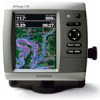
Garmin GPSMAP 536/536s Support Question
Garmin GPSMAP 536/536s Support Question
Find answers below for this question about Garmin GPSMAP 536/536s.Need a Garmin GPSMAP 536/536s manual? We have 5 online manuals for this item!
Question posted by kirkluckscheiter on August 11th, 2011
What Is The Solution For Depth Reading Irratic At Shallow Readings?
Below 10 feet, the readings jump around between 1 foot and 10 feet. It works just fine at deeper depths.
Current Answers
Related Garmin GPSMAP 536/536s Manual Pages
Installation Instructions - Page 8
...functionality matrix on the
NMEA 2000 guidelines.
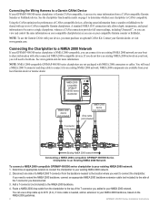
GPSMAP 400/500 Series Installation Instructions A standard NMEA 0183 connection only allows depth, temperature, and speed information to be shared ... to be sent to a single chartplotter, whereas a CANet connection provides full sonar readings, including Ultrascroll™, so you can receive sonar information from the backbone nearest to...
Installation Instructions - Page 9
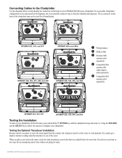
...GPS
antenna (sold separately)
➍ Compatible XM
antenna with audio adapter (sold separately)
➎ Compatible XM
antenna (sold separately)
GPSMAP 521, 541, 551
GPSMAP 526, 536, 546, and 556
Testing the Installation
To turn on your GPSMAP... the screens to work properly. GPSMAP 400/500 Series Installation Instructions You cannot get a depth or distance reading when the transducer is...
Installation Instructions - Page 10

.... Update Rate: 1/second, continuous
GPS Accuracy: Position: diagonal (10.6 cm), QVGA display with adjustable brightness, 640 × 480 pixels, capable of the transducer, make the adjustments in both directions to 55ºC)
Compass-Safe Distances:
Model Number
GPSMAP 526/536/546/556 GPSMAP 421/431/441/451 GPSMAP 521/531/541/551 GPSMAP 420/430/440/450...
Installation Instructions - Page 11
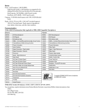
... GNSS DOPs GNSS Sats in View Wind Data
Compatible GPSMAP 400/500 series chartplotters are supported by the GPSMAP 525s/526s/535s/536s/545s/546s/555s/556s units only.) Dual Frequency, 500... National Marine Electronics Association (NMEA) format and sentences from: NMEA Seven Riggs Avenue Severna Park, MD 21146 USA www.nmea.org
GPSMAP 400/500 Series Installation Instructions
11 Depth capacity...
Quick Reference Guide - Page 1

Finding a Marine Service and Navigating to use ... 2. Select the waypoint you want to delete.
3. Select the waypoint attribute you want to change (Name, Symbol, Depth, Water Temp,
Comment, or Position). To delete a waypoint or an MOB: 1.
From the Home screen, select ... shown when more than one waypoint is in the vicinity.)
GPSMAP® 400/500 series
quick reference guide
Owner's Manual - Page 9

... Safe Zone around your boat (page 56).
GPSMAP 400/500 Series Owner's Manual
Getting Started
System Units-specify units for time readings.
AIS Alarm Range (not available if you ..., or UTC (Universal Time Coordinated) format. Position Format-specify the coordinate system to use for depth, temperature, distance, speed, elevation, volume, and pressure.
Note: You can change these settings ...
Owner's Manual - Page 23
...on or off . To customize the appearance of the screen. Blue indicates deep water, yellow is shallow water, and red is over 3D terrain.
• Classic-uses color schemes to indicate 3D ...Hazard Colors-Turns hazard colors on page 9. Mariner's Eye 3D (Water Hazard Colors) GPSMAP 400/500 Series Owner's Manual 17
The On setting indicates shallow water and land with a color scale.
...
Owner's Manual - Page 41

... backup. The BlueChart g2 Vision Mariner's Eye 3D is installed on your unit.
Navigating with NMEA 2000 compatible chartplotters (GPSMAP 441/441s, GPSMAP 536/536s, GPSMAP 541/541s, and GPSMAP 546/546s). In low-humidity ... To?
(page 43).
• Auto Guidance-uses the chart data and specified boat safe depth to determine the best course to your computer for a realistic view of your PC. You ...
Owner's Manual - Page 46

... added.
From the Home screen, select Information > Dashboard > Engine. Synchronizing Fuel Gauge Readings with Fuel Levels From the Home screen, select Information > Dashboard > Fuel (or Engine) > MENU.
• Fill Up All Tanks-select when your tanks. Select Done.
40
GPSMAP 400/500 Series Owner's Manual Viewing Information
Configuring Engine Gauges The amount...
Owner's Manual - Page 55

...time (from the calculated GPS speed).
Auto Guidance-set the time zone you transition to calculate the barometric pressure trend. If Auto is selected for time
readings. Configuring Navigation Preferences
...24-hour, or UTC time format. • Time Zone-set the Auto Guidance parameters:
GPSMAP 400/500 Series Owner's Manual
49 Heading-sets the reference used in which the map is...
Owner's Manual - Page 59
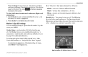
...Shallow Water-set an alarm to sound when the battery reaches a specified low voltage.
Note: You must be receiving NMEA sonar depth data or have Activation set to Time, select Change Time to work...select whether you exceed a specified drift distance.
GPS Accuracy-set the number of minutes before arrival that the alarm should sound. GPSMAP 400/500 Series Owner's Manual
53 Select ...
Owner's Manual - Page 60
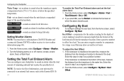
...or off: marine, tornado,...in step 3 as the Garmin GFS 10.
54
To enable the Total Fuel ... temperature that may draw several feet of water.
If you select ...a negative number to compensate for the depth of a keel, making it possible ...You must be connected to measure depth from the bottom of the keel...). 2.
Keel Offset-compensates for the surface reading for a large vessel that is installed at...
Owner's Manual - Page 61
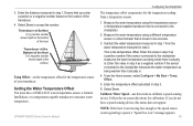
... is the temperature offset. Temp Offset-set the temperature offset for the temperature reading from the water temperature measured in step 1 from a temperature sensor.
1. Enter... the number. Select Done. Transducer at Surface A (+) positive number shows depth at the surface. GPSMAP 400/500 Series Owner's Manual
Configuring the Chartplotter
The temperature offset compensates for...
Owner's Manual - Page 63
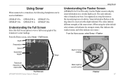
... on the ring when it is received at the depth indicated. The scale indicates what is organized as fishfinders:
GPSMAP 431s GPSMAP 441s GPSMAP 531s GPSMAP 536s GPSMAP 541s GPSMAP 546s
Understanding the Full Screen
Select the Full Screen option to view a full-screen graph of the
transducer's sonar readings. Depth of the sonar return. (When using the white default...
Owner's Manual - Page 65
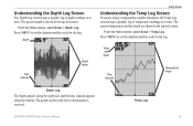
... screen keeps a graphic log of temperature readings over time.
Temp Log
GPSMAP 400/500 Series Owner's Manual
59 From the Home screen, select Sonar > Depth Log. From the Home screen, select Sonar > Temp Log. Press MENU to set the duration and the scale for the log. Press MENU to the ...
Owner's Manual - Page 79

... screen, select Information > Weather > Fishing. Strong pressure gradients are generally associated with areas of precipitation.
Pressure readings can help determine weather and wind conditions in an area.
High-pressure areas are associated with fair weather.
GPSMAP 400/500 Series Owner's Manual 73 Using XM WX Weather and Audio
Understanding Surface Pressure This...
Owner's Manual - Page 85
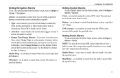
...read. Battery Alarm-battery voltage has fallen below the value entered in 10 seconds.
Can't Read User Card-error reading card; Contact your dealer or Garmin Product Support if the problem persists.
Can't Read...input voltage-the unit shuts off . GPSMAP 400/500 Series Owner's Manual 79
...to acknowledge the message.
Accuracy Alarm-the GPS accuracy has fallen outside of the dangerous ...
Owner's Manual - Page 87
...inside, or outside the specified values. Shallow Water Alarm-the Shallow Water Alarm depth has been reached.
To record more track points, you were connected to safe depth settings-the auto-guidance route was ...is not detected.
Water Speed Sensor Is Not Working-the speed sensor is full and track recording has been turned off.
GPSMAP 400/500 Series Owner's Manual 81
If the...
Owner's Manual - Page 90
... functioning of merchantability and fitness for any derivative works based on the Software. XM WX weather data...c. PLEASE READ THIS AGREEMENT CAREFULLY.
84
Garmin Ltd. You further acknowledge that the Software in the normal operation of Defense (10 U.S.C. 425... with the use the software embedded in this product. GPSMAP 400/500 Series Owner's Manual XM Satellite Radio Service ...
Owner's Manual - Page 91

...22 Chart Borders 14 chart data 10 charts
detail 13 fish eye 3D 18 fishing 19 mariner's eye 3D 16 navigation 8 settings... 53 fish 54 fuel 54 GPS accuracy 53 navigation 53 off course 53 shallow water 53 sonar 53 water temp...Defaults NMEA 0183 sentences 51 delete a waypoint 31 depth line 60 depth log 59 depth waypoint 61
Detail, chart 13 Details, AIS 25...GPSMAP 400/500 Series Owner's Manual 85 Ref.
Similar Questions

How Do I Go Into Simulation Mode On A Garmin Marine Gps Modle741xs
how do I use simulation mode on a garmin 741xs marine ver
how do I use simulation mode on a garmin 741xs marine ver
(Posted by Curthupp 6 years ago)

No Depth Readings On Gpsmap546s
Have cleaned pins on data cable, transducer, both hot wire and ground connection on data cable. Boug...
Have cleaned pins on data cable, transducer, both hot wire and ground connection on data cable. Boug...
(Posted by sue1953bc 7 years ago)


541s Marine Gps. Depth Not Reading Out.
Depth has been working since installed. Now blank. Is there an on off control for this that may have...
Depth has been working since installed. Now blank. Is there an on off control for this that may have...
(Posted by therad50 11 years ago)