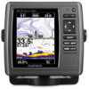
Garmin echoMAP 50s Support Question
Garmin echoMAP 50s Support Question
Find answers below for this question about Garmin echoMAP 50s.Need a Garmin echoMAP 50s manual? We have 10 online manuals for this item!
Question posted by rddries on December 7th, 2014
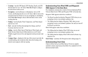
Data Bars At Top Of Main Screen
How do d get the data bars to show my current location
Current Answers
Answer #1: Posted by sabrie on December 11th, 2014 1:48 AM
sabrie
Member since:
May 23rd, 2013 Points: 3,306,778

Member since:
May 23rd, 2013 Points: 3,306,778
Please download your manual on the link below, you will get the correct instructions
www.techboss.co.za
Related Garmin echoMAP 50s Manual Pages
Quick Reference Guide - Page 1

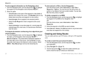
...> Move.
4.
To delete a waypoint or an MOB: 1. Finding a Marine Service and Navigating to select characters and spell at least a portion of the...location, select the location > Navigate To > Go To.
Select Create Waypoint. From the Home screen, select Charts > Navigation Chart.
2. To go to use the map pointer ( ) to view the 50 nearest destinations that contain your current location...
Quick Reference Guide - Page 2

...GPS receiver must collect satellite data and establish the current location. Select Navigate To > Route To. 3. Choose the location of the sonar, to adjust the backlight level. From the Home screen, select Information > User Data...
Use the Rocker to turn toward your current location and the map pointer location coordinates in Taiwan The bar under the number represents that distance on the...
Owner's Manual - Page 3
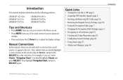
...items on the screen using the Rocker, and press the SELECT key after each item. Introduction
Quick Links
• Turning the Unit On or Off: page 2. • Acquiring GPS Satellite Signals:... For example, if you see "select Charts > Navigation Chart," you should highlight a series of the main screens to access advanced settings.
• Press and release the Power key to a Destination: page 23....
Owner's Manual - Page 11
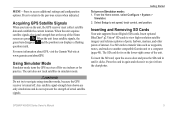
...using simulator mode, because the GPS receiver is on the unit, the GPS receiver must collect satellite data and establish the current location. Acquiring GPS Satellite Signals
When you turn on...settings and configuration options. MENU-Press to the previous screen when indicated.
When the unit loses satellite signals, the green bars disappear and the position icon displays a flashing question...
Owner's Manual - Page 15
... an automatic guidance line.
• The Sailing data bar displays Wind VMG when the Route Leg data bar is on. Chart Setup-customize the Navigation chart settings (page 11). • Cruising-turn the GPS Speed, GPS Heading, Depth, and GPS Position data bar on or off . Select Data Bar Setup to provide the current heading, and an indicator that follow the standards...
Owner's Manual - Page 16
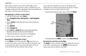
... edge of the current map display, the screen scrolls forward to provide continuous map coverage. As you can view the distance and bearing from your current location and the map pointer's location coordinates, in white...the map pointer ( ) away from your current location and to scroll to other areas on the chart to which you
want to go. 4. The bar under the number represents that distance on ...
Owner's Manual - Page 21
... anchorages. Data Bars (page 8)-show or hide the numbers for cruising, navigation, fishing, fuel, sailing, or the compass tape (page 9).
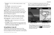
This view is helpful when navigating tricky shoals, reefs, bridges, or channels, and is beneficial when trying to provide distance measurement.
• Lane Width-adjusts the width of the screen.
15 Using Mariner's Eye...
Owner's Manual - Page 22

... When the cursor is very shallow water.
For settings and options related to Waypoints & Tracks, Other Vessels, and Data Bars, see "Navigation Chart Menu" on or off to view details about navaids such as seen from the Mariner's Eye 3D screen, press MENU. The On setting indicates shallow water and land with a color scale.
Owner's Manual - Page 23

... (such as fish).
Data Bars-show or hide cruising, navigation, fishing, fuel, or sailing numbers (page 8). Using Fishing Charts
Use the Fishing chart for the Fish Eye 3D screen, press MENU.
Sonar Cone (only available if sonar is present)-displays suspended targets (such as a GPSMAP 526s) and a transducer wired through a marine network to adjust...
Owner's Manual - Page 31
... Rocker to move the pointer to edit.
3. OR From the Home screen, select Information > User Data > Waypoints. 2. To move the waypoint on the Navigation chart.
2. Select ...Depth, Water Temp, Comment, or Position).
Press SELECT.
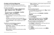
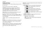
• Use Current Position-Create a waypoint at your current location as a waypoint: From any screen, press the MARK key.
• Edit Waypoint-designate a specific name...
Owner's Manual - Page 32
... MENU > Stop Measuring to other locations.
OR From the Home screen, select Information > User Data > Waypoints.
2.
You can also filter the list by distance from your present location: 1. To delete a waypoint or... navigate to the selected location.
• Select Create Waypoint to mark a waypoint at which you want to make the last turn toward your current location. You can create and...
Owner's Manual - Page 44
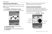
... about sunrise, sunset, moonrise, moonset, the moon phase, and the approximate sky view location of the sun and moon. Select a current station. Select Show Report to view information for currents. Viewing Information
Viewing Current Information
Use the Current Prediction screen to view the Current Prediction Report for the selected station.
38
Overhead Sun position Moon position
Moon...
Owner's Manual - Page 66
... transducer is capable), battery voltage, cruising, navigation, and the compass tape (page 9).
Data Bars-show or hide depth, water temperature, water speed (if your boat.
Hide surface noise...: To display water temperature or water speed, the connected transducer must be capable of the screen.
To set how the sonar interprets suspended targets.
◦◦ Select to show suspended ...
Owner's Manual - Page 80

... 54 GPS accuracy 54...mariner's eye 3D 15 navigation 7 settings 11 Clear User Data 39 collision alarm 56 colors, hazard 16 Color Scheme 61 Communications 51 Compass 31 compass rose 12 Compass Tape 9 contact information, Garmin iv coordinates, grid creating waypoints using 25 course up 12 current stations 38 customizing chart settings 11
D
Dashboard 31 data
transfer 40 Data Bars...
Owner's Manual - Page 81
...50 viewing 39
75 Fishing 9 fishing chart 17 Fish Symbols 17, 60 frequency 61 Fuel Capacity 56 fuel gauge 35 full screen, sonar 57 fuse 68
G
gain 61 Garmin Data Transfer 51 go to 23 GPS 5, 48, 68 GPS...Man Overboard 25, 64 Manual Zoom 61 map datum 49 MapSource data 39 mariner's eye 3D 15
colors 16 mark current location 25 measuring distance 26 MENU key 5 messages 69 move a ...
Owner's Manual - Page 82
...
route to 23
S
safe-zone settings 56 Safe Depth 16, 50 Safe Height 50 Safety Shading 13 sailing data bar 9 SART 42 satellite imagery
enabling 18 Saved Tracks 15 Save To... viewing
currents 38 other boats 41 tide stations 37 user data 39
W
WAAS 48 water temperature 70 Waypoint IDs 52 waypoints 15
creating 25 deleting 25, 26 depth 61 edit existing 15, 25 mark current location 25...
Technical Reference for Garmin NMEA 2000 Products - Page 27

...your current position.
1. The speed filter is gathered. • Auto-the speed filter toggles on your display device.
While viewing the NMEA 2000 configuration menu, select the GPS ...Speed Filter. 3.
Technical Reference for the GPS 17x to provide smoother position data updates. For more -accurate position information. Select Config > Auto Locate. 3. Wait for Garmin NMEA 2000 ...
Technical Reference for Garmin NMEA 2000 Products - Page 37
...For most Garmin chartplotters, select Review > Temperature Offset. • For other Garmin marine devices, select Config > Factory Defaults. 3. Select Yes. Select an option:
• For ..., select the GST 10 device. 2. Select the location of the trim tab position as temperature data displayed on -screen instructions to enter additional, optional trim tab positions.
...
Weather Supplement - Page 6
... Wave Period and Wave Period Forecast (page 7) Forecasting Fish Locations (page 9) Visibility (page 9) and Visibility Forecast (page 10) National Weather Station Marine Local Forecast (page 10) Buoy Data (page 10) Sea Surface Temperature and Sea Surface Pressure (... current location. Buy WX-you purchase cellular weather data or when the chartplotter automatically requests a cellular ...
Weather Supplement - Page 20
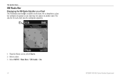
... XM Radio data bar ➊ is available on another chart. On a chartplotter, a data bar configured to appear on one chart may not appear on all charts. Select a chart. 3. The data bar for each chart must be configured separately.
➊
1. Select MENU > Data Bars > XM Audio > On.
16
GPSMAP 400/500 Series Weather Supplement From the Home screen, select Charts...
Similar Questions

There Is No Map On My Echomap 50s. Everything Else Works Including Speedometer.
(Posted by dave66232 3 years ago)

How Do You Put The'time/clock' On The Main Screen Of The Gpsmap 188c?
(Posted by charlottehingle90 5 years ago)
How Do I Go Into Simulation Mode On A Garmin Marine Gps Modle741xs
how do I use simulation mode on a garmin 741xs marine ver
how do I use simulation mode on a garmin 741xs marine ver
(Posted by Curthupp 6 years ago)

How to get the measures in meters with echomap 50
How to set the units of measurement in meters with echomap and 50s, audible fish presence
How to set the units of measurement in meters with echomap and 50s, audible fish presence
(Posted by masillo 9 years ago)

Why Is The Gps Tab Not Visible Anymore On Main Screen?
We lost GPS signal and now it has the triangle with a red question mark in it. Don't know how to get...
We lost GPS signal and now it has the triangle with a red question mark in it. Don't know how to get...
(Posted by Jlthomas1120 11 years ago)