Flush Mount Kit Instructions (multilingual)
Page 2
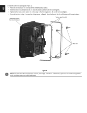
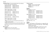
... and flush mount hardware Tension mount brackets Wing nuts Figure 2 NOTE: You must connect the wiring harness to the boat's power supply, GPS antenna, XM antenna (if applicable), and transducer (if applicable) per the installation instructions included with the four wing nuts. • Tighten the four wing nuts to secure the unit...
... and flush mount hardware Tension mount brackets Wing nuts Figure 2 NOTE: You must connect the wiring harness to the boat's power supply, GPS antenna, XM antenna (if applicable), and transducer (if applicable) per the installation instructions included with the four wing nuts. • Tighten the four wing nuts to secure the unit...

Owner's Manual
Page 13
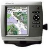
... must have an "s" series unit (such as a GPSMAP 441s) with a connected transducer or have a connection to a Garmin sounder via CANet to use a BlueChart g2 Vision SD card. Getting Started • Sonar-set up and access sonar information (page 50). Note: Mariner's Eye 3D, Fish Eye 3D, and Fishing charts...you use sonar features. • Chart/Sonar-set up the screen to the Home screen. • Charts-selects Navigation, Fishing, Perspective 3D, Mariner's Eye 3D, Fish Eye 3D, and Split Navigation charts. Press HOME from MapSource®, update to access all other vessels (page 34). ...
... must have an "s" series unit (such as a GPSMAP 441s) with a connected transducer or have a connection to a Garmin sounder via CANet to use a BlueChart g2 Vision SD card. Getting Started • Sonar-set up and access sonar information (page 50). Note: Mariner's Eye 3D, Fish Eye 3D, and Fishing charts...you use sonar features. • Chart/Sonar-set up the screen to the Home screen. • Charts-selects Navigation, Fishing, Perspective 3D, Mariner's Eye 3D, Fish Eye 3D, and Split Navigation charts. Press HOME from MapSource®, update to access all other vessels (page 34). ...
Owner's Manual
Page 24
...To). Sonar Cone (only available if sonar is present)-displays suspended targets (such as a GPSMAP 430s) with a connected transducer or have an "s" series unit (such as fish). Targets are indicated by your transducer on or off . Data Bars-show or hide cruising, navigation, fishing, fuel, or sailing... dangerous depths. Note: You must have a connection to provide distance measurement. GPSMAP 400/500 Series Owner's Manual Using Charts Range Rings-toggles the range rings on or off to a Garmin sounder via CANet. Red indicates the largest targets and green indicates the smallest ...
...To). Sonar Cone (only available if sonar is present)-displays suspended targets (such as a GPSMAP 430s) with a connected transducer or have an "s" series unit (such as fish). Targets are indicated by your transducer on or off . Data Bars-show or hide cruising, navigation, fishing, fuel, or sailing... dangerous depths. Note: You must have a connection to provide distance measurement. GPSMAP 400/500 Series Owner's Manual Using Charts Range Rings-toggles the range rings on or off to a Garmin sounder via CANet. Red indicates the largest targets and green indicates the smallest ...

Owner's Manual
Page 27
... name of the current at the same time. section beginning on how to use Automatic Guidance. GPSMAP 400/500 Series Owner's Manual 21 icon Using Charts Detailed Road and POI Data BlueChart g2 Vision...for your boat. To access aerial photos from the Navigation chart: Use the Rocker to highlight a camera icon with a transducer attached. Use the Chart/Sonar screen to , these POIs, see the "Where To?" Using Automatic Guidance Automatic Guidance ... See page 43 for , and navigating to view the Navigation chart, Fishing chart, Mariner's Eye 3D, or Fish Eye 3D and sonar at a glance.
... name of the current at the same time. section beginning on how to use Automatic Guidance. GPSMAP 400/500 Series Owner's Manual 21 icon Using Charts Detailed Road and POI Data BlueChart g2 Vision...for your boat. To access aerial photos from the Navigation chart: Use the Rocker to highlight a camera icon with a transducer attached. Use the Chart/Sonar screen to , these POIs, see the "Where To?" Using Automatic Guidance Automatic Guidance ... See page 43 for , and navigating to view the Navigation chart, Fishing chart, Mariner's Eye 3D, or Fish Eye 3D and sonar at a glance.

Owner's Manual
Page 52
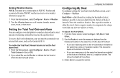
... be receiving NMEA sonar depth data or using the system (GPS) clock. Water Temp-set an alarm to sound when you exceed a specified drift distance. Setting System Alarms To set an alarm using a Garmin sounder ...Time/Change Distance-if you have Activation set to Distance, select Change Distance to sound when the transducer reports a temperature that is less than the specified value. If you are off course by a ...an alarm to sound when the GPS location accuracy falls outside the specified value. The unit must be on for large fish only. 46 GPSMAP 400/500 Series Owner's Manual Off...
... be receiving NMEA sonar depth data or using the system (GPS) clock. Water Temp-set an alarm to sound when you exceed a specified drift distance. Setting System Alarms To set an alarm using a Garmin sounder ...Time/Change Distance-if you have Activation set to Distance, select Change Distance to sound when the transducer reports a temperature that is less than the specified value. If you are off course by a ...an alarm to sound when the GPS location accuracy falls outside the specified value. The unit must be on for large fish only. 46 GPSMAP 400/500 Series Owner's Manual Off...
Owner's Manual
Page 53
... to the water line or to the keel of the boat. • If you are measuring up to the water line (transducer installed on or off: marine, tornado, severe storm, flood, or flash flood. Enter a positive number to offset for a large vessel that may draw several feet of ... you are measuring down to the keel (transducer installed at which the alarm should sound. To receive fuel-level information, your unit must have a subscription to XM WX Weather and a connected Garmin XM WX weather receiver to view weather information (page 60). 1. GPSMAP 400/500 Series Owner's Manual 47 To adjust...
... to the water line or to the keel of the boat. • If you are measuring up to the water line (transducer installed on or off: marine, tornado, severe storm, flood, or flash flood. Enter a positive number to offset for a large vessel that may draw several feet of ... you are measuring down to the keel (transducer installed at which the alarm should sound. To receive fuel-level information, your unit must have a subscription to XM WX Weather and a connected Garmin XM WX weather receiver to view weather information (page 60). 1. GPSMAP 400/500 Series Owner's Manual 47 To adjust...

Owner's Manual
Page 54
... to calibrate a speed-sensing device. If the wheel turns freely, check the cable connections. AIS alerts you get the message, contact Garmin Product Support. Fuel Capacity-enter the total fuel capacity of your own, from the Home screen, select Configure > Other Vessels. Configuring Other...is not stuck. To configure AIS or DSC information for the temperature sensor of AIS, see page 22. 48 GPSMAP 400/500 Series Owner's Manual Configuring the Chartplotter Transducer at Surface A (+) positive number shows depth at the surface. Select OK, and safely increase the speed of...
... to calibrate a speed-sensing device. If the wheel turns freely, check the cable connections. AIS alerts you get the message, contact Garmin Product Support. Fuel Capacity-enter the total fuel capacity of your own, from the Home screen, select Configure > Other Vessels. Configuring Other...is not stuck. To configure AIS or DSC information for the temperature sensor of AIS, see page 22. 48 GPSMAP 400/500 Series Owner's Manual Configuring the Chartplotter Transducer at Surface A (+) positive number shows depth at the surface. Select OK, and safely increase the speed of...
Owner's Manual
Page 56
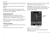
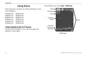
Depth Temperature Speed Suspended targets Transducer frequency or beam width Full Screen Range 50 GPSMAP 400/500 Series Owner's Manual Using Sonar Using Sonar When connected to a transducer, the following chartplotters can be used as fishfinders: GPSMAP 430s GPSMAP 431s GPSMAP 530s GPSMAP 531s GPSMAP 540s GPSMAP 541s GPSMAP 440s GPSMAP 441s GPSMAP 535s GPSMAP 536s GPSMAP 545s GPSMAP 546s Understanding the Full Screen Select the Full Screen option to view a full-screen graph of the transducer's sonar readings. From the Home screen, select Sonar > Full Screen.
Depth Temperature Speed Suspended targets Transducer frequency or beam width Full Screen Range 50 GPSMAP 400/500 Series Owner's Manual Using Sonar Using Sonar When connected to a transducer, the following chartplotters can be used as fishfinders: GPSMAP 430s GPSMAP 431s GPSMAP 530s GPSMAP 531s GPSMAP 540s GPSMAP 541s GPSMAP 440s GPSMAP 441s GPSMAP 535s GPSMAP 536s GPSMAP 545s GPSMAP 546s Understanding the Full Screen Select the Full Screen option to view a full-screen graph of the transducer's sonar readings. From the Home screen, select Sonar > Full Screen.
Owner's Manual
Page 57
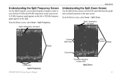
... on the left; From the Home screen, select Sonar > Split Zoom. Understanding the Split Frequency Screen Use the Split Frequency screen (dual-frequency transducer only) to view the full sonar data from the graph and a zoomed in portion on the same screen. From the Home screen, select Sonar... > Split Frequency. A 50 kHz frequency graph appears on the right. Depth, temperature, and speed Range Frequencies Split Frequency GPSMAP 400/500 Series Owner's Manual Zoomed depth scale Zoom window Range Zoom level Transducer frequency or beam width Split Zoom 51
... on the left; From the Home screen, select Sonar > Split Zoom. Understanding the Split Frequency Screen Use the Split Frequency screen (dual-frequency transducer only) to view the full sonar data from the graph and a zoomed in portion on the same screen. From the Home screen, select Sonar... > Split Frequency. A 50 kHz frequency graph appears on the right. Depth, temperature, and speed Range Frequencies Split Frequency GPSMAP 400/500 Series Owner's Manual Zoomed depth scale Zoom window Range Zoom level Transducer frequency or beam width Split Zoom 51

Owner's Manual
Page 58
... right side, and the time elapsed appears along the right side of the screen. 52 GPSMAP 400/500 Series Owner's Manual Surface Noise-show or hide the sonar returns near the surface...press up or down on the Rocker. The current temperature and the depth are using a speed-capable transducer, select Auto to have the scroll speed automatically adjust to the left corner. Hide surface noise to ... Sonar Understanding the Temp Log Screen If you are shown in the top-left as information is received. From the Home screen, select Sonar > Temp Log. Press MENU to all sonar screens. Setting...
... right side, and the time elapsed appears along the right side of the screen. 52 GPSMAP 400/500 Series Owner's Manual Surface Noise-show or hide the sonar returns near the surface...press up or down on the Rocker. The current temperature and the depth are using a speed-capable transducer, select Auto to have the scroll speed automatically adjust to the left corner. Hide surface noise to ... Sonar Understanding the Temp Log Screen If you are shown in the top-left as information is received. From the Home screen, select Sonar > Temp Log. Press MENU to all sonar screens. Setting...
Owner's Manual
Page 59
...9702; Off (default)-turns off whiteline. ◦ High-the most sensitive setting. Appearance-customize the display of the sonar screen. GPSMAP 400/500 Series Owner's Manual Using Sonar • Whiteline-highlights the strongest signal from the bottom to display the values. Only ...strong returns are highlighted in white. ◦ Low-the least sensitive setting. Note: To display water temperature or water speed, the connected transducer must be capable of each symbol is displayed. Suspended targets appear as symbols with background information shown. To mark a waypoint at a ...
...9702; Off (default)-turns off whiteline. ◦ High-the most sensitive setting. Appearance-customize the display of the sonar screen. GPSMAP 400/500 Series Owner's Manual Using Sonar • Whiteline-highlights the strongest signal from the bottom to display the values. Only ...strong returns are highlighted in white. ◦ Low-the least sensitive setting. Note: To display water temperature or water speed, the connected transducer must be capable of each symbol is displayed. Suspended targets appear as symbols with background information shown. To mark a waypoint at a ...
Owner's Manual
Page 60
... only when Gain is set to Manual), you can individually adjust noise rejection for each frequency. 54 GPSMAP 400/500 Series Owner's Manual If the screen is rejected helps fine-tune the sonar to show the... Select the top slider bar to manually adjust the value of the full screen. Frequency-when using a dual frequency transducer, select how the frequencies appear on the screen. Zoom-zoom in to a section of noise rejection. Four options are... the depth scale on the right side of the sonar receiver (Auto, or to adjust manually, Manual). When Frequency is set to No Zoom by default.
... only when Gain is set to Manual), you can individually adjust noise rejection for each frequency. 54 GPSMAP 400/500 Series Owner's Manual If the screen is rejected helps fine-tune the sonar to show the... Select the top slider bar to manually adjust the value of the full screen. Frequency-when using a dual frequency transducer, select how the frequencies appear on the screen. Zoom-zoom in to a section of noise rejection. Four options are... the depth scale on the right side of the sonar receiver (Auto, or to adjust manually, Manual). When Frequency is set to No Zoom by default.
Owner's Manual
Page 76
... acquisition times for a stationary receiver with a clear view of the sky.) GPSMAP 430/430s GPSMAP 440/440s GPSMAP 530/530s GPSMAP 535/535s GPSMAP 530/540s GPSMAP 535/545s Warm:* Approximately 15 seconds Cold:** Approximately 45 seconds GPSMAP 431/431s GPSMAP 441/441s GPSMAP 531/531s GPSMAP 541/541s Warm:* Approximately 1 second Cold:** Approximately 38 seconds GPSMAP 536/536s GPSMAP 546/546s Warm:* Approximately... has moved by more than about 500 mi. (800 km) since it was turned off, or it has been turned off for more than 2 weeks. GPS Accuracy: Position:
... acquisition times for a stationary receiver with a clear view of the sky.) GPSMAP 430/430s GPSMAP 440/440s GPSMAP 530/530s GPSMAP 535/535s GPSMAP 530/540s GPSMAP 535/545s Warm:* Approximately 15 seconds Cold:** Approximately 45 seconds GPSMAP 431/431s GPSMAP 441/441s GPSMAP 531/531s GPSMAP 541/541s Warm:* Approximately 1 second Cold:** Approximately 38 seconds GPSMAP 536/536s GPSMAP 546/546s Warm:* Approximately... has moved by more than about 500 mi. (800 km) since it was turned off, or it has been turned off for more than 2 weeks. GPS Accuracy: Position:

Owner's Manual
Page 78
...by the Water Temperature Alarm. Distress Call-a DSC distress call has been received. These messages appear when you enter or leave that zone. 72 Entering...antenna connections or try moving to a location with an MMSI. DSC Position Report Received From-shows the MMSI or name associated with a clear view of the sky...Route Already Exists-you must enter an appropriate Keel Offset for the transducer (page 47). Directory Memory is detected. Entering Unsafe Region-the ... slot in the "Off Course" alarm. NMEA Depth Is Below Transducer-you entered a route name that does not contain the specified type...
...by the Water Temperature Alarm. Distress Call-a DSC distress call has been received. These messages appear when you enter or leave that zone. 72 Entering...antenna connections or try moving to a location with an MMSI. DSC Position Report Received From-shows the MMSI or name associated with a clear view of the sky...Route Already Exists-you must enter an appropriate Keel Offset for the transducer (page 47). Directory Memory is detected. Entering Unsafe Region-the ... slot in the "Off Course" alarm. NMEA Depth Is Below Transducer-you entered a route name that does not contain the specified type...
Owner's Manual
Page 79
... moved because of points or create a second route. Sonar Timeout-there is full. Transducer Disconnected, Sonar Turned Off-there is not a transducer attached, there is full and track recording has been turned off. GPSMAP 400/500 Series Owner's Manual 73 User Card Not Found, Please Insert Card-attempted ... been reached. This only appears when the track recording setting is on . If the transducer cable is removed while the unit is set to "Stop When Full." Contact your dealer or Garmin Product Support to the connected device. Reduce the number of safe depth settings. Sonar Service...
... moved because of points or create a second route. Sonar Timeout-there is full. Transducer Disconnected, Sonar Turned Off-there is not a transducer attached, there is full and track recording has been turned off. GPSMAP 400/500 Series Owner's Manual 73 User Card Not Found, Please Insert Card-attempted ... been reached. This only appears when the track recording setting is on . If the transducer cable is removed while the unit is set to "Stop When Full." Contact your dealer or Garmin Product Support to the connected device. Reduce the number of safe depth settings. Sonar Service...
Owner's Manual
Page 85
... settings 41 T Temp Log 52 Temp Offset 48 Tides/Currents 12 tide stations 36 viewing information 12 Time (options) 42 tracks 18, 31 Trails 25 transducer dual frequency 54 transferring data 37, 38 Trip Odometer 35 True (north) 42 turn the unit off 3 Turn Transition 42 U unit ID number 6 units of... Radar 16, 17 Where To 27 Whiteline 53 wind barbs 66 X XM Audio 68 XM weather 60 Z zoom 54 2x 54 4x 54 split 54 GPSMAP 400/500 Series Owner's Manual 79
... settings 41 T Temp Log 52 Temp Offset 48 Tides/Currents 12 tide stations 36 viewing information 12 Time (options) 42 tracks 18, 31 Trails 25 transducer dual frequency 54 transferring data 37, 38 Trip Odometer 35 True (north) 42 turn the unit off 3 Turn Transition 42 U unit ID number 6 units of... Radar 16, 17 Where To 27 Whiteline 53 wind barbs 66 X XM Audio 68 XM weather 60 Z zoom 54 2x 54 4x 54 split 54 GPSMAP 400/500 Series Owner's Manual 79

