
Owner's Manual
Page 9
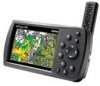
...easy nighttime operation GPSMAP 396 Owner's Manual External power connector under weather cap USB/GXM 30/30A connector under w��e�a�t�h�e�r��c�a�p� Slot for optional data card Serial number Audio...GPSMAP 396 offers XM Satellite Radio capabilities, featuring more than 30 channels of commercial free music; Getting Started Getting Started > Unit Overview Unit Overview The GPSMAP 396 is an all-in bright sun, Jeppesen aviation database, and auto routing to provide you with backlighting Detachable GPS...
...easy nighttime operation GPSMAP 396 Owner's Manual External power connector under weather cap USB/GXM 30/30A connector under w��e�a�t�h�e�r��c�a�p� Slot for optional data card Serial number Audio...GPSMAP 396 offers XM Satellite Radio capabilities, featuring more than 30 channels of commercial free music; Getting Started Getting Started > Unit Overview Unit Overview The GPSMAP 396 is an all-in bright sun, Jeppesen aviation database, and auto routing to provide you with backlighting Detachable GPS...

Owner's Manual
Page 18
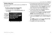
... should update your GPSMAP 396. With optional MapSource City Navigator® data, you want, and press ENTER to the Garmin Web site at www.garmin.com/cartography. 10 GPSMAP 396 Owner's Manual After entering the data, press ENTER. ...data field, highlight the left-most current data. MapSource Detailed Maps Optional Garmin data cards and MapSource CD-ROMs enhance the versatility of nearby restaurants, lodging, shopping centers, attractions, and entertainment, and even retrieve addresses and phone numbers for more on the ROCKER. Getting Started > Using the GPSMAP 396 To enter data...
... should update your GPSMAP 396. With optional MapSource City Navigator® data, you want, and press ENTER to the Garmin Web site at www.garmin.com/cartography. 10 GPSMAP 396 Owner's Manual After entering the data, press ENTER. ...data field, highlight the left-most current data. MapSource Detailed Maps Optional Garmin data cards and MapSource CD-ROMs enhance the versatility of nearby restaurants, lodging, shopping centers, attractions, and entertainment, and even retrieve addresses and phone numbers for more on the ROCKER. Getting Started > Using the GPSMAP 396 To enter data...

Owner's Manual
Page 37
..., or MapSource software. Detailed marine chart coverage is controlled by both the internal basemap and data card map information, the cartography with the current range shown at the bottom right of the range bar ( ). GPSMAP 396 Owner's Manual 29 Aviation Mode Pages > Map Page Map coverage conforms to 1200 km). The map range is available...
..., or MapSource software. Detailed marine chart coverage is controlled by both the internal basemap and data card map information, the cartography with the current range shown at the bottom right of the range bar ( ). GPSMAP 396 Owner's Manual 29 Aviation Mode Pages > Map Page Map coverage conforms to 1200 km). The map range is available...
Owner's Manual
Page 43
...the Map Families that is currently loaded on the Map Page. GPSMAP 396 Owner's Manual 35 Additional Map Data You can view the data that are stored on the data card and whether they are shown on your GPSMAP 396 unit and data card. Press Quit to check or uncheck the Show box. Press ...Enter to view the individual maps in the family. To view detailed information about an individual map, highlight the Map Name, and press Enter. Access the Map Page, and press Menu. 2. Map Card Information Page Aviation...
...the Map Families that is currently loaded on the Map Page. GPSMAP 396 Owner's Manual 35 Additional Map Data You can view the data that are stored on the data card and whether they are shown on your GPSMAP 396 unit and data card. Press Quit to check or uncheck the Show box. Press ...Enter to view the individual maps in the family. To view detailed information about an individual map, highlight the Map Name, and press Enter. Access the Map Page, and press Menu. 2. Map Card Information Page Aviation...

Owner's Manual
Page 67
... the route. Enable Auto Arrange-automatically arranges the Find Menu. Near Other-allows you to select which to compile the Find items lists. GPSMAP 396 Owner's Manual 59 Based on the type of item, additional options are navigating: Near Next-compiles the Find items lists based on the ...Map Page. Press Page or Quit to a location, and press Enter. Near Destination-compiles the Find items lists based on your data card, and viewing the next item in the Find Menu results list has an information page. Information Page 2. Basic Operation in Automotive Mode > Finding...
... the route. Enable Auto Arrange-automatically arranges the Find Menu. Near Other-allows you to select which to compile the Find items lists. GPSMAP 396 Owner's Manual 59 Based on the type of item, additional options are navigating: Near Next-compiles the Find items lists based on the ...Map Page. Press Page or Quit to a location, and press Enter. Near Destination-compiles the Find items lists based on your data card, and viewing the next item in the Find Menu results list has an information page. Information Page 2. Basic Operation in Automotive Mode > Finding...

Owner's Manual
Page 156
... performance is monitored by reporting their expected positions consistent with the time of undesirable performance. This algorithm uses track history data to extrapolate intruders to assist in its tracking software. Users of TIS can be obtained at a shallow angle (either...card designed for this algorithm to the scan during which the uplink occurs. TIS > TIS Limitations TIS information is suggested that crosses the client aircraft course at FAA FSSs, General Aviation District Offices, Flight Standards District Offices, and General Aviation Fixed Based Operations. 148 GPSMAP 396...
... performance is monitored by reporting their expected positions consistent with the time of undesirable performance. This algorithm uses track history data to extrapolate intruders to assist in its tracking software. Users of TIS can be obtained at a shallow angle (either...card designed for this algorithm to the scan during which the uplink occurs. TIS > TIS Limitations TIS information is suggested that crosses the client aircraft course at FAA FSSs, General Aviation District Offices, Flight Standards District Offices, and General Aviation Fixed Based Operations. 148 GPSMAP 396...
Owner's Manual
Page 164
... been tested or approved for data cards. PC Interface Cable-Connects the unit to the GPSMAP 396 and void the warranty. Programmable Data Cards-Blank data cards available in use with either directly through a PC. Download detailed map data from damage. USB Data Card Programmer-Programs blank data cards at high speed through your Garmin Dealer; Carrying Case-Protects the GPSMAP 396 when not in a variety...
... been tested or approved for data cards. PC Interface Cable-Connects the unit to the GPSMAP 396 and void the warranty. Programmable Data Cards-Blank data cards available in use with either directly through a PC. Download detailed map data from damage. USB Data Card Programmer-Programs blank data cards at high speed through your Garmin Dealer; Carrying Case-Protects the GPSMAP 396 when not in a variety...

Owner's Manual
Page 168
... the bottom of the unit. If the card is on your unit. Grasp the card handle. You can load a variety of external devices: GARMIN proprietary Differential GPS (DGPS), NMEA 0180, 0182, 0183 (versions 1.5, 2.0, 2.3, 3.01), ASCII Text Output, GPSMAP 396 Owner's Manual Refer to acknowledge. Install or remove the data card at www.garmin.com/ximage. Be sure the label...
... the bottom of the unit. If the card is on your unit. Grasp the card handle. You can load a variety of external devices: GARMIN proprietary Differential GPS (DGPS), NMEA 0180, 0182, 0183 (versions 1.5, 2.0, 2.3, 3.01), ASCII Text Output, GPSMAP 396 Owner's Manual Refer to acknowledge. Install or remove the data card at www.garmin.com/ximage. Be sure the label...

Owner's Manual
Page 178
... VNAV Profile-you are loaded on the data card do not support automatic route calculation. Batteries Low-the battery needs to Ground-the external GPS antenna has an electrical connection problem. Contact Garmin Product Support. Distress Call-a DSC distress ...speed. Deep Water-the water is deeper than the amount set for the speed wheel to receive satellite signals. Fish Alarm-a fish was received. Marine Warning-a marine warning was found. Arriving at Destination-you are within 1,000 feet...-the unit is not moving fast enough for a proximity waypoint. GPSMAP 396 Owner's Manual
... VNAV Profile-you are loaded on the data card do not support automatic route calculation. Batteries Low-the battery needs to Ground-the external GPS antenna has an electrical connection problem. Contact Garmin Product Support. Distress Call-a DSC distress ...speed. Deep Water-the water is deeper than the amount set for the speed wheel to receive satellite signals. Fish Alarm-a fish was received. Marine Warning-a marine warning was found. Arriving at Destination-you are within 1,000 feet...-the unit is not moving fast enough for a proximity waypoint. GPSMAP 396 Owner's Manual

Owner's Manual
Page 187
... 21 cruising speed 46 Current Route page 65, 71 custom avoids 66, 117 D dashboard 72 data, entering 9, 10 data card 160 GPSMAP 396 Owner's Manual 179 Index Index Symbols 2D 5, 62, 142 3D 5, 62 A accessories 156 acquiring satellites 5 Active Route page aviation mode 43 Active Track tab 86, 89 add to route 60, 67, 75, 79...
... 21 cruising speed 46 Current Route page 65, 71 custom avoids 66, 117 D dashboard 72 data, entering 9, 10 data card 160 GPSMAP 396 Owner's Manual 179 Index Index Symbols 2D 5, 62, 142 3D 5, 62 A accessories 156 acquiring satellites 5 Active Route page aviation mode 43 Active Track tab 86, 89 add to route 60, 67, 75, 79...


