Installation Instructions
Page 2
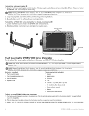
...) from a magnetic compass to flush mount your GPSMAP 3000 series chartplotter. Using an appropriately sized drill bit, drill the pilot holes for the wiring. Secure the bail mount to avoid interference. 2. Bail mount Flush Mounting the GPSMAP 3000 Series Chartplotter Use the included flush-mount template...Using the bail mount as a template, mark the location of the template to the GPSMAP 3000 series chartplotter. 2. Be sure to leave at which you want to fit the chartplotter and the connected wires. Trim the template and ensure it will fit in the location at least 2 in...
...) from a magnetic compass to flush mount your GPSMAP 3000 series chartplotter. Using an appropriately sized drill bit, drill the pilot holes for the wiring. Secure the bail mount to avoid interference. 2. Bail mount Flush Mounting the GPSMAP 3000 Series Chartplotter Use the included flush-mount template...Using the bail mount as a template, mark the location of the template to the GPSMAP 3000 series chartplotter. 2. Be sure to leave at which you want to fit the chartplotter and the connected wires. Trim the template and ensure it will fit in the location at least 2 in...
Installation Instructions
Page 5
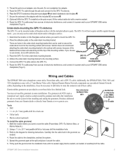
...GPS 17x. 2. Adhesive pads 3. Adhere the under -deck mounting bracket. 4. Additionally, the GPSMAP 3006, 3206, 3010, and 3210 chartplotters come with extreme care. Trim to weatherproof the cable. Apply marine sealant, as needed , to this hole (no trim) for the Marine Video cable. GPSMAP... GPS 17x, Marine Video, or Marine Network.) 2. The GPS 17x will extend beyond the top of these holes for trimming instructions. Place the GPS 17x in some installations. Wiring and Cables The GPSMAP 3000 series chartplotter comes with a marine sealant. 9. Optional Garmin Marine ...
...GPS 17x. 2. Adhesive pads 3. Adhere the under -deck mounting bracket. 4. Additionally, the GPSMAP 3006, 3206, 3010, and 3210 chartplotters come with extreme care. Trim to weatherproof the cable. Apply marine sealant, as needed , to this hole (no trim) for the Marine Video cable. GPSMAP... GPS 17x, Marine Video, or Marine Network.) 2. The GPS 17x will extend beyond the top of these holes for trimming instructions. Place the GPS 17x in some installations. Wiring and Cables The GPSMAP 3000 series chartplotter comes with a marine sealant. 9. Optional Garmin Marine ...
Installation Instructions
Page 6
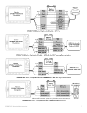
... includes NMEA input with support for use with the Garmin GPS 17x GPS antenna. You can input one chartplotter on signal Orange Port 4: Data in parallel to the wiring diagram that equipment. If networking two or more GPSMAP 3000, 4000, or 5000 series chartplotters are installed... series chartplotter using the 18-pin Power/Data wiring harness interfacing with support for use with heat shrink tubing. Documentation concerning NMEA and RTCM formats and sentences are supported for purchase from: National Marine Electronics Association (NMEA) Seven Riggs Avenue Severna Park, MD...
... includes NMEA input with support for use with the Garmin GPS 17x GPS antenna. You can input one chartplotter on signal Orange Port 4: Data in parallel to the wiring diagram that equipment. If networking two or more GPSMAP 3000, 4000, or 5000 series chartplotters are installed... series chartplotter using the 18-pin Power/Data wiring harness interfacing with support for use with heat shrink tubing. Documentation concerning NMEA and RTCM formats and sentences are supported for purchase from: National Marine Electronics Association (NMEA) Seven Riggs Avenue Severna Park, MD...
Installation Instructions
Page 7
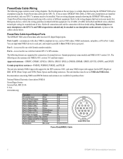
... Fuse Red 1A Unconnected Black White/ Orange White/Red Purple Orange White > Gray GPSMAP 3000 Series Chartplotter Wired to a GPS 17x GPS 17x > > > > > Garmin GPSMAP 3000 Series Chartplotter Wire Fuse Color 3A Red � � Battery 10-33 Vdc Wire Type Power Black > Blue (port 1) Brown (port 1) > Gray (port 2) OR Violet (port 2) Ground NMEA TX/RX- (B) NMEA Rx...
... Fuse Red 1A Unconnected Black White/ Orange White/Red Purple Orange White > Gray GPSMAP 3000 Series Chartplotter Wired to a GPS 17x GPS 17x > > > > > Garmin GPSMAP 3000 Series Chartplotter Wire Fuse Color 3A Red � � Battery 10-33 Vdc Wire Type Power Black > Blue (port 1) Brown (port 1) > Gray (port 2) OR Violet (port 2) Ground NMEA TX/RX- (B) NMEA Rx...
Installation Instructions
Page 8
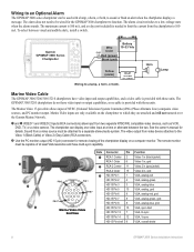
...Marine Video Cable The GPSMAP 3006/3206/3010/3210 chartplotters have video input and output capabilities, and a video cable is provided with those units. Marine Video inputs are only available on a computer monitor. The chartplotter can be capable of at a time or alternate between visual and audible alerts, install a switch. The Marine...limit the current from video device attaches to a low-voltage state when the alarm sounds. Garmin GPSMAP 3000 Series Chartplotter + - Battery Wire 10-33 Vdc Color Fuse 3 A Red (power) Black (gnd) Yellow (alarm) Relay 100 ma max ...
...Marine Video Cable The GPSMAP 3006/3206/3010/3210 chartplotters have video input and output capabilities, and a video cable is provided with those units. Marine Video inputs are only available on a computer monitor. The chartplotter can be capable of at a time or alternate between visual and audible alerts, install a switch. The Marine...limit the current from video device attaches to a low-voltage state when the alarm sounds. Garmin GPSMAP 3000 Series Chartplotter + - Battery Wire 10-33 Vdc Color Fuse 3 A Red (power) Black (gnd) Yellow (alarm) Relay 100 ma max ...
Installation Instructions
Page 10
...Power/NMEA cable with the card. If you are connecting the GPSMAP 3000 series chartplotter to a Garmin Marine Network, insert the RJ-45 connector into the NETWORK port on www.garmin.com, or contact www.garmin.com/support. If your GPSMAP 3000 series Owner's Manual for steps on the backside of the... Data card is not included, visit www.garmin.com to make sure your chartplotter software is not connected to a Garmin Marine Network, be sure to firmly affix the weather cap over the open the Main Menu. 2. Final Wiring Connection After all the wiring is complete, the cables are attached on...
...Power/NMEA cable with the card. If you are connecting the GPSMAP 3000 series chartplotter to a Garmin Marine Network, insert the RJ-45 connector into the NETWORK port on www.garmin.com, or contact www.garmin.com/support. If your GPSMAP 3000 series Owner's Manual for steps on the backside of the... Data card is not included, visit www.garmin.com to make sure your chartplotter software is not connected to a Garmin Marine Network, be sure to firmly affix the weather cap over the open the Main Menu. 2. Final Wiring Connection After all the wiring is complete, the cables are attached on...
Owner's Manual
Page 14
...GPSMAP 3206/3210 Owner's Manual Press and hold ADJ/MENU to search for attached devices. Numbers above the horizon, and the center point a location directly overhead. The outer circle represents the horizon (north up), the inner circle 45º above 33 indicate WAAS satellites. Getting Started Getting Started > Initializing the GPS Receiver Initializing the GPS Receiver...WAAS. • Gray-lost GPS connection. (Check GPS antenna wiring connections.) The GPS tab on the right side of the satellite acquisition, GPS receiver status, and accuracy. When viewing the GPS Info sub tab, a signal...
...GPSMAP 3206/3210 Owner's Manual Press and hold ADJ/MENU to search for attached devices. Numbers above the horizon, and the center point a location directly overhead. The outer circle represents the horizon (north up), the inner circle 45º above 33 indicate WAAS satellites. Getting Started Getting Started > Initializing the GPS Receiver Initializing the GPS Receiver...WAAS. • Gray-lost GPS connection. (Check GPS antenna wiring connections.) The GPS tab on the right side of the satellite acquisition, GPS receiver status, and accuracy. When viewing the GPS Info sub tab, a signal...
Owner's Manual
Page 62
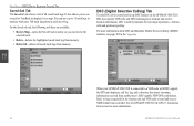
... information. 54 GPSMAP 3206/3210 Owner's Manual It also allows you can save up to send and receive NMEA data from each saved log. DSC is required for two major operations-distress calls and position reporting. Basic wiring is used by mariners for the Garmin unit and VHF... All-deletes all saved track logs. Main Menu When your GPSMAP 3206/3210 is connected to transmit and receive location information. See the GPSMAP 3206/3210 & GPS 17 Installation Instructions for TracBack or display it on the GPSMAP 3206/3210. DSC (Digital Selective Calling) Tab Use the DSC tab to...
... information. 54 GPSMAP 3206/3210 Owner's Manual It also allows you can save up to send and receive NMEA data from each saved log. DSC is required for two major operations-distress calls and position reporting. Basic wiring is used by mariners for the Garmin unit and VHF... All-deletes all saved track logs. Main Menu When your GPSMAP 3206/3210 is connected to transmit and receive location information. See the GPSMAP 3206/3210 & GPS 17 Installation Instructions for TracBack or display it on the GPSMAP 3206/3210. DSC (Digital Selective Calling) Tab Use the DSC tab to...

Owner's Manual
Page 71
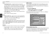
... variation as a magnetic compass. When using this setting can result in substantial differences between the information displayed on wiring and NMEA information. Main Menu GPSMAP 3206/3210 Owner's Manual 63 To enter a user-defined magnetic variation: 1. Comm (Communications) Sub Tab The Comm sub...present location. The unit supports two input/output ports. Enter the magnetic variation at your location changes. Note: See the GPSMAP 3206/3210 & GPS17 Installation Instructions for daylight saving time to adjust for daylight saving time. With the Heading field set to User ...
... variation as a magnetic compass. When using this setting can result in substantial differences between the information displayed on wiring and NMEA information. Main Menu GPSMAP 3206/3210 Owner's Manual 63 To enter a user-defined magnetic variation: 1. Comm (Communications) Sub Tab The Comm sub...present location. The unit supports two input/output ports. Enter the magnetic variation at your location changes. Note: See the GPSMAP 3206/3210 & GPS17 Installation Instructions for daylight saving time to adjust for daylight saving time. With the Heading field set to User ...
Owner's Manual
Page 72
...for most AIS receivers. • None-provides no interfacing capabilities. When transferring data between two Garmin units, always set...number of Lat/Lon output precision digits. See the GPSMAP 3206/3210 & GPS 17 Installation Instructions for the DPT, MTW, and VHW... ENTER. 2. Advanced NMEA Output Setup The GPSMAP 3206/3210 NMEA data transmission can choose from nine Garmin Data Transfer Modes. • NMEA In/...wiring and NMEA data. You can also adjust the NMEA output. • None-provides no interfacing capabilities. Main Menu Main Menu > System Tab Port 1 • Garmin...
...for most AIS receivers. • None-provides no interfacing capabilities. When transferring data between two Garmin units, always set...number of Lat/Lon output precision digits. See the GPSMAP 3206/3210 & GPS 17 Installation Instructions for the DPT, MTW, and VHW... ENTER. 2. Advanced NMEA Output Setup The GPSMAP 3206/3210 NMEA data transmission can choose from nine Garmin Data Transfer Modes. • NMEA In/...wiring and NMEA data. You can also adjust the NMEA output. • None-provides no interfacing capabilities. Main Menu Main Menu > System Tab Port 1 • Garmin...
Owner's Manual
Page 112
... support, the GPS unit displays a Call List, Log, and a Directory to exchange and display the positions of the caller. Basic wiring is an FAA (Federal Aviation Administration) funded project to send and receive NMEA data from this system.. Because WAAS requires CPU resources of the GPSMAP 3206/3210 to search for the Garmin unit and VHF...
... support, the GPS unit displays a Call List, Log, and a Directory to exchange and display the positions of the caller. Basic wiring is an FAA (Federal Aviation Administration) funded project to send and receive NMEA data from this system.. Because WAAS requires CPU resources of the GPSMAP 3206/3210 to search for the Garmin unit and VHF...
Owner's Manual
Page 118
... the maximum of the Drift Alarm value. Contact your dealer or Garmin Product Support. Can't Send Waypoint-the unit cannot transmit the waypoint using the NMEA WPL sentence. Database Error-internal problem with the GPS antenna wiring. Take appropriate action. Invalid MMSI- Lost Satellite Reception-the unit ... Limited To Bottom Of Range-voltage range must be between 10.0 and 35.0 volts for the GPSMAP 3206/3210. Can't Write User Card-error reading card; Distress Call-a DSC distress call has been received. Fish Alarm-shows an icon and a beep sounds (if enabled) when a fish is already...
... the maximum of the Drift Alarm value. Contact your dealer or Garmin Product Support. Can't Send Waypoint-the unit cannot transmit the waypoint using the NMEA WPL sentence. Database Error-internal problem with the GPS antenna wiring. Take appropriate action. Invalid MMSI- Lost Satellite Reception-the unit ... Limited To Bottom Of Range-voltage range must be between 10.0 and 35.0 volts for the GPSMAP 3206/3210. Can't Write User Card-error reading card; Distress Call-a DSC distress call has been received. Fish Alarm-shows an icon and a beep sounds (if enabled) when a fish is already...


