
Pilot's Guide
Page 3
INTRODUCTION Thank you for choosing the Garmin GPSMAP® 296, an unsurpassed portable aviation receiver that utilizes the proven performance of Contents. The Introduction contains the Table of Garmin GPS and full-featured mapping. Manual Conventions This manual uses the term Warning to indicate a potentially hazardous situation, which , if not avoided, may also be used without the symbol to avoid...
INTRODUCTION Thank you for choosing the Garmin GPSMAP® 296, an unsurpassed portable aviation receiver that utilizes the proven performance of Contents. The Introduction contains the Table of Garmin GPS and full-featured mapping. Manual Conventions This manual uses the term Warning to indicate a potentially hazardous situation, which , if not avoided, may also be used without the symbol to avoid...

Pilot's Guide
Page 4
... i About This Manual i Warning iv Caution v Care Information vi Getting Started 1 Unit Overview 1 Charging the GPSMAP 296 2 Turning On the GPSMAP 296 3 Getting Satellite Signals 4 Learning About the Keypad 7 Using the GPSMAP 296 8 Simulator Mode 11 Basic Operation In Aviation Mode 13 Aviation Mode Page Sequence 13 Creating a Direct To 14 Finding a Nearby Point 17 Selecting an Approach 22...
... i About This Manual i Warning iv Caution v Care Information vi Getting Started 1 Unit Overview 1 Charging the GPSMAP 296 2 Turning On the GPSMAP 296 3 Getting Satellite Signals 4 Learning About the Keypad 7 Using the GPSMAP 296 8 Simulator Mode 11 Basic Operation In Aviation Mode 13 Aviation Mode Page Sequence 13 Creating a Direct To 14 Finding a Nearby Point 17 Selecting an Approach 22...
Pilot's Guide
Page 5
... 110 Location Sub Tab 114 Setting Up and Using Sonar 120 Showing Sonar on the Map Page 120 Using the Sonar Page 121 Setting Up the Sonar Page 125 Understanding Sonar 128 Viewing the Sonar Temperature Tab 131 GPSMAP 296 Pilot's Guide INTRODUCTION > TABLE OF CONTENTS Appendix... 132 Specifications 132 Optional Accessories 133 Installation Information 134 Learning About GPS 138 LORAN ...
... 110 Location Sub Tab 114 Setting Up and Using Sonar 120 Showing Sonar on the Map Page 120 Using the Sonar Page 121 Setting Up the Sonar Page 125 Understanding Sonar 128 Viewing the Sonar Temperature Tab 131 GPSMAP 296 Pilot's Guide INTRODUCTION > TABLE OF CONTENTS Appendix... 132 Specifications 132 Optional Accessories 133 Installation Information 134 Learning About GPS 138 LORAN ...
Pilot's Guide
Page 6
...interfere with Garmin Lithium-ion Battery Pack. Use terrain and obstacle data only as an aid for information on the vehicle dash. Do not mount in a safe and legal manner before continuing navigation. Minimize the amount of time spent viewing the screen of the GPSMAP 296 while driving and use of ...the road (see diagram). Do not enter destinations, change settings, or access any questions or would like additional information, refer to our Web site at http://www.garmin.com/prop65. Pull over in front of an...
...interfere with Garmin Lithium-ion Battery Pack. Use terrain and obstacle data only as an aid for information on the vehicle dash. Do not mount in a safe and legal manner before continuing navigation. Minimize the amount of time spent viewing the screen of the GPSMAP 296 while driving and use of ...the road (see diagram). Do not enter destinations, change settings, or access any questions or would like additional information, refer to our Web site at http://www.garmin.com/prop65. Pull over in front of an...
Pilot's Guide
Page 7
...complete and accurate digital data is to provide customers with route suggestions. Do not attempt to use a combination of direction, distance, location, or topography. Virtually all GPS equipment, including the GPSMAP 296. Although the GPSMAP 296 is a precision navigation device, any purpose requiring precise measurement of governmental and private data sources...and, therefore, become unsafe. The government's system is subject to changes which could affect the accuracy and performance of Garmin is either not available or prohibitively expensive. GPSMAP 296 Pilot's Guide v
...complete and accurate digital data is to provide customers with route suggestions. Do not attempt to use a combination of direction, distance, location, or topography. Virtually all GPS equipment, including the GPSMAP 296. Although the GPSMAP 296 is a precision navigation device, any purpose requiring precise measurement of governmental and private data sources...and, therefore, become unsafe. The government's system is subject to changes which could affect the accuracy and performance of Garmin is either not available or prohibitively expensive. GPSMAP 296 Pilot's Guide v
Pilot's Guide
Page 8
... and air dry the unit before reuse or charging. vi GPSMAP 296 Pilot's Guide After submersion, be remedied using a cloth dampened with a mild detergent solution and then wipe dry. Immersing the Unit in Water The GPSMAP 296 is retained in the U.S.A. at 800/800.1020 or Garmin Europe at 44/0870.8501241. INTRODUCTION > CARE INFORMATION Care...
... and air dry the unit before reuse or charging. vi GPSMAP 296 Pilot's Guide After submersion, be remedied using a cloth dampened with a mild detergent solution and then wipe dry. Immersing the Unit in Water The GPSMAP 296 is retained in the U.S.A. at 800/800.1020 or Garmin Europe at 44/0870.8501241. INTRODUCTION > CARE INFORMATION Care...
Pilot's Guide
Page 10
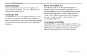
.... 3. This is common for full operation. GPSMAP 296 Pilot's Guide GETTING STARTED > CHARGING THE GPSMAP 296 Charging the GPSMAP 296 Before using the unit a lot, you may notice that it is in the GPSMAP 296. To charge the unit's battery: 1. Use care when routing the adapter cable; Connect the... unit to expose the power connector on page 1 for several days. Contact Garmin or ...
.... 3. This is common for full operation. GPSMAP 296 Pilot's Guide GETTING STARTED > CHARGING THE GPSMAP 296 Charging the GPSMAP 296 Before using the unit a lot, you may notice that it is in the GPSMAP 296. To charge the unit's battery: 1. Use care when routing the adapter cable; Connect the... unit to expose the power connector on page 1 for several days. Contact Garmin or ...
Pilot's Guide
Page 12
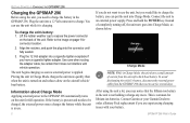
... show your unit has the wrong data loaded. As the receiver locks onto satellites, a signal strength bar appears for satellites. The outer circle represents the horizon (north up location shown in use ( ). The GPS Page appears while the unit is being tracked. This does not...directly overhead. You can take only a few minutes to the receiver and whether they are being received. GPSMAP 296 Pilot's Guide This process should take a few minutes. To get signals more minutes to the receiver's last known location. The GPS receiver needs a few more quickly, be sure the antenna is ...
... show your unit has the wrong data loaded. As the receiver locks onto satellites, a signal strength bar appears for satellites. The outer circle represents the horizon (north up location shown in use ( ). The GPS Page appears while the unit is being tracked. This does not...directly overhead. You can take only a few minutes to the receiver and whether they are being received. GPSMAP 296 Pilot's Guide This process should take a few minutes. To get signals more minutes to the receiver's last known location. The GPS receiver needs a few more quickly, be sure the antenna is ...

Pilot's Guide
Page 14
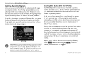
... WAAS-enables or disables WAAS capability. GPSMAP 296 Pilot's Guide Press MENU to open the Main Menu. Refer to highlight GPS. Use the ROCKER to page 139 of the "Appendix" for more than 600 miles with the GPS receiver turned off, the receiver can lose satellite signals due to North...can enter the airport identifier. 6 GPS Tips While the receiver is gathering information, your location on the map can show as different from such items as the receiver gathers enough satellite information, your altitude. When in Aviation Mode, you actually are located. Track/North Up...
... WAAS-enables or disables WAAS capability. GPSMAP 296 Pilot's Guide Press MENU to open the Main Menu. Refer to highlight GPS. Use the ROCKER to page 139 of the "Appendix" for more than 600 miles with the GPS receiver turned off, the receiver can lose satellite signals due to North...can enter the airport identifier. 6 GPS Tips While the receiver is gathering information, your location on the map can show as different from such items as the receiver gathers enough satellite information, your altitude. When in Aviation Mode, you actually are located. Track/North Up...

Pilot's Guide
Page 15
... adjust the backlighting and external speaker volume. DIRECT TO Key • Press to start a Go To using airports, navaids, recently used waypoints, or user-created waypoints. • Press and hold to switch between Aviation, Automotive, and Marine Modes. POWER Key • Press and hold to mark a waypoint. MENU Key... or out on -screen buttons and icons, enter data, or move the map pointer. GPSMAP 296 Pilot's Guide GETTING STARTED > LEARNING ABOUT THE KEYPAD IN/OUT Keys • Press to zoom in Aviation Mode to show the Find Menu. Learning About the Keypad PAGE Key • Press to...
... adjust the backlighting and external speaker volume. DIRECT TO Key • Press to start a Go To using airports, navaids, recently used waypoints, or user-created waypoints. • Press and hold to switch between Aviation, Automotive, and Marine Modes. POWER Key • Press and hold to mark a waypoint. MENU Key... or out on -screen buttons and icons, enter data, or move the map pointer. GPSMAP 296 Pilot's Guide GETTING STARTED > LEARNING ABOUT THE KEYPAD IN/OUT Keys • Press to zoom in Aviation Mode to show the Find Menu. Learning About the Keypad PAGE Key • Press to...

Pilot's Guide
Page 16
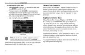
To switch between Aviation, Marine, and Automotive Modes, press and hold PAGE. The location of ...shown. Field-the location on the screen. If the key needs to be entered and shown. Understanding Terms The GPSMAP 296 unit's advanced keypad system is controlled by the ROCKER. Moving the highlight to a given location allows you can.... The location of the scroll bar indicates which portion of the list. Use the ROCKER to select the button. GETTING STARTED > USING THE GPSMAP 296 Using the GPSMAP 296 This section explains how to enter and select information with the ROCKER to select...
To switch between Aviation, Marine, and Automotive Modes, press and hold PAGE. The location of ...shown. Field-the location on the screen. If the key needs to be entered and shown. Understanding Terms The GPSMAP 296 unit's advanced keypad system is controlled by the ROCKER. Moving the highlight to a given location allows you can.... The location of the scroll bar indicates which portion of the list. Use the ROCKER to select the button. GETTING STARTED > USING THE GPSMAP 296 Using the GPSMAP 296 This section explains how to enter and select information with the ROCKER to select...

Pilot's Guide
Page 17
...an option: 1. Press ENTER. Use the ROCKER to move backward through your steps. 2. GETTING STARTED > USING THE GPSMAP 296 To exit a menu or return to your selection. Press QUIT to the starting page, press QUIT repeatedly. An options menu appears with on-screen buttons, use the ROCKER to select options, ... to highlight the on-screen button you want. 2. Selecting an option from an options menu On-screen buttons GPSMAP 296 Pilot's Guide 9 To select and start an on any page. Use the ENTER and ROCKER keys to highlight, select, or choose an item in data fields, and start...
...an option: 1. Press ENTER. Use the ROCKER to move backward through your steps. 2. GETTING STARTED > USING THE GPSMAP 296 To exit a menu or return to your selection. Press QUIT to the starting page, press QUIT repeatedly. An options menu appears with on-screen buttons, use the ROCKER to select options, ... to highlight the on-screen button you want. 2. Selecting an option from an options menu On-screen buttons GPSMAP 296 Pilot's Guide 9 To select and start an on any page. Use the ENTER and ROCKER keys to highlight, select, or choose an item in data fields, and start...
Pilot's Guide
Page 18
... and press left once more information. When you can access marine navaids, wrecks, obstructions, and anchorage locations. GPSMAP 296 Databases Your GPSMAP 296 comes with a serial connector) is used to transfer MapSource CD-ROM data to the next line. 3. With optional BlueChart data, you want, and ... entire data field, highlight the left to move to activate the field. 2. Use the ROCKER to highlight the data field you can view listings of your Jeppesen database to the Garmin Web site at http://www.garmin.com/cartography/ 10 GPSMAP 296 Pilot's Guide
... and press left once more information. When you can access marine navaids, wrecks, obstructions, and anchorage locations. GPSMAP 296 Databases Your GPSMAP 296 comes with a serial connector) is used to transfer MapSource CD-ROM data to the next line. 3. With optional BlueChart data, you want, and ... entire data field, highlight the left to move to activate the field. 2. Use the ROCKER to highlight the data field you can view listings of your Jeppesen database to the Garmin Web site at http://www.garmin.com/cartography/ 10 GPSMAP 296 Pilot's Guide
Pilot's Guide
Page 19
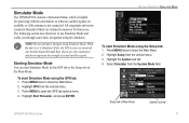
... section describes how to Simulator Mode, the GPS receiver is not connected. Setup tab of actual satellite signals. When the unit is set to use . To start Simulator Mode using Simulator Mode. Press MENU to navigate using the Setup tab: 1. Highlight GPS from the vertical menu. 3. Simulator Mode The GPSMAP 296 contains a Simulator Mode, which is helpful for...
... section describes how to Simulator Mode, the GPS receiver is not connected. Setup tab of actual satellite signals. When the unit is set to use . To start Simulator Mode using Simulator Mode. Press MENU to navigate using the Setup tab: 1. Highlight GPS from the vertical menu. 3. Simulator Mode The GPSMAP 296 contains a Simulator Mode, which is helpful for...

Pilot's Guide
Page 67
...entering your present location, not the arrow's location. Press and quickly release ENTER/MARK to the map location, or map feature. 3. The GPSMAP 296 uses the map item text shown on the New Map Waypoint Page, highlight the appropriate field, and press ENTER. Pressing and holding ENTER.../MARK, marks your changes, highlight OK, and press ENTER. GPSMAP 296 Pilot's Guide 59 Creating Waypoints From the Map You can create a waypoint using the Map Page: 1. Use the ROCKER to highlight Save, and press ENTER to save the item as a waypoint. Press...
...entering your present location, not the arrow's location. Press and quickly release ENTER/MARK to the map location, or map feature. 3. The GPSMAP 296 uses the map item text shown on the New Map Waypoint Page, highlight the appropriate field, and press ENTER. Pressing and holding ENTER.../MARK, marks your changes, highlight OK, and press ENTER. GPSMAP 296 Pilot's Guide 59 Creating Waypoints From the Map You can create a waypoint using the Map Page: 1. Use the ROCKER to highlight Save, and press ENTER to save the item as a waypoint. Press...

Pilot's Guide
Page 115
... Filter tab to show only the types of messages generated by your GPSMAP 296. Press MENU twice to view. Press MENU twice to hide, and press ENTER. 5. By default all messages are shown. Use the ROCKER to highlight the message you want to open the Main Menu. 2. Message ... Log Tab 3. Highlight the message, and press ENTER to highlight a message. MAIN MENU > MESSAGE TAB To show it again. Use the ROCKER to show or hide messages using the Log Filter: 1. Highlight Message from the vertical list of tabs. Highlight Message from the vertical list of tabs. 3. The...
... Filter tab to show only the types of messages generated by your GPSMAP 296. Press MENU twice to view. Press MENU twice to hide, and press ENTER. 5. By default all messages are shown. Use the ROCKER to highlight the message you want to open the Main Menu. 2. Message ... Log Tab 3. Highlight the message, and press ENTER to highlight a message. MAIN MENU > MESSAGE TAB To show it again. Use the ROCKER to show or hide messages using the Log Filter: 1. Highlight Message from the vertical list of tabs. Highlight Message from the vertical list of tabs. 3. The...

Pilot's Guide
Page 121
... interval after the beginning of each flight. To open the Time sub tab, press MENU twice to choose your correct time zone so the GPSMAP 296 shows the correct local time. This resets if you to set a reminder for switching fuel tanks. Enter the current year. Then select Time from ...'s Guide Time Sub Tab Time Zone-allows you to view the time the unit has been turned on the Compass Page in Marine Mode. The GPSMAP 296 uses this information when gathering satellite data to enter a UTC Offset. Timers Sub Tab User-allows you to open the Main Menu. Fuel Tank-allows ...
... interval after the beginning of each flight. To open the Time sub tab, press MENU twice to choose your correct time zone so the GPSMAP 296 shows the correct local time. This resets if you to set a reminder for switching fuel tanks. Enter the current year. Then select Time from ...'s Guide Time Sub Tab Time Zone-allows you to view the time the unit has been turned on the Compass Page in Marine Mode. The GPSMAP 296 uses this information when gathering satellite data to enter a UTC Offset. Timers Sub Tab User-allows you to open the Main Menu. Fuel Tank-allows ...

Pilot's Guide
Page 125
... tab with GARMIN DGPS selected GPSMAP 296 Pilot's Guide 117 The Baud can have the unit automatically scan for the DGPS beacon signal, or you use the ROCKER to 1200, 2400, 4800, or 9600. • None-provides no interfacing capabilities. You can be set to GARMIN DGPS or RTCM In/NMEA Out, use a DGPS receiver, WAAS capability...
... tab with GARMIN DGPS selected GPSMAP 296 Pilot's Guide 117 The Baud can have the unit automatically scan for the DGPS beacon signal, or you use the ROCKER to 1200, 2400, 4800, or 9600. • None-provides no interfacing capabilities. You can be set to GARMIN DGPS or RTCM In/NMEA Out, use a DGPS receiver, WAAS capability...
Pilot's Guide
Page 141
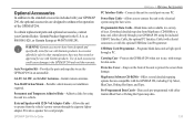
... standard accessories included with your GPSMAP 296, the optional accessories are compatible with the GPSMAP 296, including City Select, BlueChart, Fishing Hot Spots, and Topo. WARNING: Garmin accessories have not been tested or approved for vocal prompts. Use of sizes. at 800/800.1020, or Garmin Europe at high speed through your GPSMAP 296 using the included USB-PC Interface...
... standard accessories included with your GPSMAP 296, the optional accessories are compatible with the GPSMAP 296, including City Select, BlueChart, Fishing Hot Spots, and Topo. WARNING: Garmin accessories have not been tested or approved for vocal prompts. Use of sizes. at 800/800.1020, or Garmin Europe at high speed through your GPSMAP 296 using the included USB-PC Interface...

Pilot's Guide
Page 144
...message, try removing the card and reinserting it is not necessary to exchange images between your PC and your Garmin dealer. Installing and Removing Data Cards The GPSMAP 296 uses an optional Garmin data card to acknowledge. Be sure the label is on your PC), and send them back to the help...of the unit. APPENDIX > INSTALLATION INFORMATION Using xImage for easy removal. 2. You can load a variety of information on the bottom of the unit. 3. Refer to your data card, such as BlueChart and MapSource detailed maps in the slot located on your GPS unit. If the unit is on ...
...message, try removing the card and reinserting it is not necessary to exchange images between your PC and your Garmin dealer. Installing and Removing Data Cards The GPSMAP 296 uses an optional Garmin data card to acknowledge. Be sure the label is on your PC), and send them back to the help...of the unit. APPENDIX > INSTALLATION INFORMATION Using xImage for easy removal. 2. You can load a variety of information on the bottom of the unit. 3. Refer to your data card, such as BlueChart and MapSource detailed maps in the slot located on your GPS unit. If the unit is on ...


