
Garmin eTrex 10 Support Question
Garmin eTrex 10 Support Question
Find answers below for this question about Garmin eTrex 10.Need a Garmin eTrex 10 manual? We have 2 online manuals for this item!
Question posted by Bnmnnook on November 8th, 2012
Using A Route On An Etrex 19
I am new to gps when I use a route on the unit, does it automatically progress to the next waypoint once iI have reached waypoint 1
Current Answers
Related Garmin eTrex 10 Manual Pages
Owner's Manual - Page 1

eTrex®
owner's manual
for use with models 10, 20, 30
Owner's Manual - Page 3

... Alarm 24 Calculating the Size of Contents
Getting Started 5 Device Overview 5 Using the eTrex Keys 6 Battery Information 7 Turning the Device On or Off.........8 Satellite Signals 8 Registering Your Device 8
Waypoints, Routes, and Tracks 9 Waypoints 9 Using Sight 'N Go 10 Where To? Table of an Area....25 Using the Calculator 25 Viewing the Calendar and
Almanacs 25 Setting an Alarm...
Owner's Manual - Page 5

...➋ Back key ➌ Thumb Stick™ ➍ Menu key ➎ /Backlight key
eTrex Owner's Manual
5 Getting Started
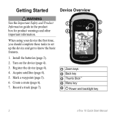
Getting Started
Device Overview
‹ warning
See the Important Safety and ... for product warnings and other
important information.
➍
➋ ➌
➎
When using your device the first time, you should complete these tasks to set up the device and ...
Owner's Manual - Page 6

... step in the menu structure.
• Press menu to zoom in and out on the map.
6
eTrex Owner's Manual Getting Started
➏ ➐
➑ ➒
➏ Mini-USB port (under ...weather cap) ➐ Battery cover ➑ Battery cover locking ring ➒ Mounting spine
Using the eTrex Keys
• Move the Thumb Stick up, down, left, and right to highlight menu selections or...
Owner's Manual - Page 9

...Select a waypoint. 3. eTrex Owner's Manual
9 Waypoints, Routes, and Tracks
Waypoints
Waypoints are locations you must create a waypoint.
1. Select Mark Waypoint. 2.
Select a waypoint. 3. Select Done. Deleting a Waypoint 1. Editing a Waypoint Before you can save the waypoint without changes, select Done.
• To make changes to the waypoint, select an item to edit. 4. Enter the new...
Owner's Manual - Page 10

When the Sample Confidence status bar reaches 100%, select Save. For best results, collect four to the object.
1. Select a unit of a location.
3. Select Start.
5. You can point the device at least 90 minutes between samples. Move to the object, and select Done > Save.
10
eTrex Owner's Manual Using Sight 'N Go
Sight 'N Go is available on the...
Owner's Manual - Page 11

..., TOPO, and City Navigator® detailed maps. Select Where To? > menu >
Search Near.
2. eTrex Owner's Manual
11 Additional Maps You can use additional maps on your Garmin dealer.
For more information, go to . Select menu > Spell Search.
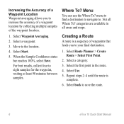
4. Where To?
Waypoints, Routes, and Tracks
Finding a Location by Name Depending on the maps loaded on the...
Owner's Manual - Page 12

... code. Select the city. 5. Routes
A route is
complete. 6. Select Route Planner > Create
Route > Select First Point. 2. Repeat steps 2-4 until the route is a sequence of a Route 1.
Select Change Name. 4. Creating a Route 1. Select the first point in the route. 4. Select Use > Select Next Point. 5. Editing the Name of waypoints that leads you to save the route. Enter the street. Select...
Owner's Manual - Page 13

...
Select Edit Route.
4. Select a route. 3. Deleting a Route 1. Select Delete Route. While navigating a route, select
Active Route. 2. Select Reverse Route. Waypoints, Routes, and Tracks
Viewing a Route on the route, select Insert. Select Route Planner. 2. Viewing the Active Route 1.
Reversing a Route 1. Select a route. 3.
Select a route.
3.
Select a point in the route to save...
Owner's Manual - Page 14

...8226; To record tracks at a specified time, select Time.
5.
Select Record Interval. 6. eTrex Owner's Manual Select Record, Do Not Show or Record, Show On Map. Select Setup ... of your path. NOTE: Using the Most Often interval provides the most track detail, but fills up the device memory quicker.
• Enter a time or distance, and select Done. Waypoints, Routes, and Tracks
Tracks
A track...
Owner's Manual - Page 16

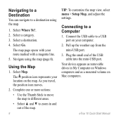
... 1. You can use the map (page 16) or compass (page 17) to navigate to any saved location in and out of the map.
16
eTrex Owner's Manual
The map page opens with your route marked with a magenta line on the map.
When you travel, moves.
Navigation
Navigation
You can navigate a route, a track, to a waypoint, to...
Owner's Manual - Page 17

...
Compass
The eTrex 30 has a 3-axis, electronic compass. You can use a bearing pointer or a course pointer to navigate to the destination.
3.
Follow the turns in your destination.
Before you can use the map, you must purchase and load City Navigator maps. Navigating a Driving Route Driving route navigation is using the automotive profile, the compass displays GPS heading...
Owner's Manual - Page 19

...Details about a Point on the Plot
Select an individual point on the course deviation indicator. eTrex Owner's Manual
19
Use the course pointer to navigate
to a destination (page 16).
2. By default, the elevation...Course (CDI) (page 34).
1. Elevation Plot
Elevation plotting is available on the eTrex 30.
Select Compass. 3. Navigating with the Course Pointer Before you can change the pointer ...
Owner's Manual - Page 24

... Proximity Alarm
Proximity alarms alert you when you must be within a specified range of a compatible Garmin device.
1. Select Use.
6. Enter a radius.
7.
Applications
Applications
Sharing Data
The eTrex 30 can share waypoints, geocaches, routes, and tracks. Select Proximity Alarms.
2. Select Send or Receive. 3. Select a category.
4. Select Share Wirelessly. 2. Select Create Alarm...
Owner's Manual - Page 27

Select Satellite > menu > Use With GPS Off.
2. Select Use. Select menu > Set Location On Map.
3.
Select a location.
4. Applications
eTrex Owner's Manual
27 Simulating a Location Before you can simulate a location, you must turn off GPS (page 26).
1.
Owner's Manual - Page 55

... driving routes 37
E editing
profiles 30 routes 12 waypoints 9
eTrex Owner's Manual
elevation plot 19, 20 barometric altimeter 20 of a track 15
F file types 43 finding
addresses 12 near your location 11 fishing times 25 fitness options 46
G geocaches 21, 35
downloading 21 filter list 21 logging attempt 22 navigating to 22 settings 35 GPS signals...
Owner's Manual - Page 56

Index
myGarmin 8
N navigating 16
driving routes 17 to a geocache 22 to waypoints 9 with bearing pointer 18 with course pointer 19 north up 31
O orientation, map 31...10 software
updating 40 version 40 stopwatch 26 storing the device 42 sunrise and sunset times 25, 50 system settings 30
T text size, maps 32 time
alarms 26 data fields 50 settings 33 sunrise and sunset
25, 50 zone 33 tones 31
56
eTrex...
Quick Start Manual - Page 2
When using your device the first time, you should complete these tasks to set up the device and get to know the basic features.
1. Turn on the device (page 4).
3. Mark a waypoint (page 5)....key
➎ Power and backlight key
2
eTrex 10 Quick Start Manual Install the batteries (page 3).
2. Acquire satellites (page 4).
5. Create a route (page 6).
7. Getting Started
Device Overview
...
Quick Start Manual - Page 6
... four to save the route.
6
eTrex 10 Quick Start Manual Select a category. 3. Repeat steps 2-4 until the route is a sequence of the waypoint location.
1. Select a waypoint.
3.
Not all areas and maps. Select Route Planner > Create Route > Select First Point.
2. Select back to eight samples for the waypoint, waiting at least 90 minutes between samples. Menu
You can use the Where To...
Quick Start Manual - Page 8
... computers. Your device appears as removable drives in and out of the USB cable into the mini-USB port. eTrex 10 Quick Start Manual The map page opens with your route marked with a magenta line. 5. Using the Map
1. Plug the small end of the map.
8
Tip: To customize the map view, select menu > Setup...


