
Pilot's Guide
Page 3
... choosing the Garmin GPSMAP® 296, an unsurpassed portable aviation receiver that utilizes the proven performance of Aviation Mode, such as the Trip Computer Page and creating waypoints. The Introduction contains the Table of the manual for your Garmin dealer immediately. INTRODUCTION > ABOUT THIS MANUAL The Basic Operation in detail, the main pages and features of Garmin GPS and...
... choosing the Garmin GPSMAP® 296, an unsurpassed portable aviation receiver that utilizes the proven performance of Aviation Mode, such as the Trip Computer Page and creating waypoints. The Introduction contains the Table of the manual for your Garmin dealer immediately. INTRODUCTION > ABOUT THIS MANUAL The Basic Operation in detail, the main pages and features of Garmin GPS and...
Pilot's Guide
Page 9
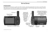
.... Press tab down to receive satellite signals. Battery pack. GETTING STARTED GETTING STARTED > UNIT OVERVIEW Unit Overview The GPSMAP 296 is an all-in basemap, Jeppesen aviation database, and auto routing to the Appendix, page 137, for instructions on page iv for more information about the lithium-ion battery pack. GPS antenna 256-Color TFT...
.... Press tab down to receive satellite signals. Battery pack. GETTING STARTED GETTING STARTED > UNIT OVERVIEW Unit Overview The GPSMAP 296 is an all-in basemap, Jeppesen aviation database, and auto routing to the Appendix, page 137, for instructions on page iv for more information about the lithium-ion battery pack. GPS antenna 256-Color TFT...

Pilot's Guide
Page 14
... tree cover. When in Aviation Mode, you actually are located. Be patient; GETTING STARTED > GETTING SATELLITE SIGNALS GPS Tab Options Press MENU two times to page 139 of the "Appendix" for more than 600 miles with the GPS receiver turned off, the receiver can lose satellite signals due...North Up or Track Up. as soon as the receiver gathers enough satellite information, your proper location is shown on the map can enter the airport identifier. 6 GPS Tips While the receiver is recommended. Monitoring the GPS status is gathering information, your unit. GPSMAP 296 Pilot's Guide
... tree cover. When in Aviation Mode, you actually are located. Be patient; GETTING STARTED > GETTING SATELLITE SIGNALS GPS Tab Options Press MENU two times to page 139 of the "Appendix" for more than 600 miles with the GPS receiver turned off, the receiver can lose satellite signals due...North Up or Track Up. as soon as the receiver gathers enough satellite information, your proper location is shown on the map can enter the airport identifier. 6 GPS Tips While the receiver is recommended. Monitoring the GPS status is gathering information, your unit. GPSMAP 296 Pilot's Guide
Pilot's Guide
Page 20
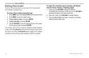
.... 3. Highlight New Location, and press ENTER. 4. Press down on the ROCKER to simulate from the GPS tab options menu. GETTING STARTED > SIMULATOR MODE Entering a New Location From the GPS options menu you want, and press ENTER. To enter a New Location using the ROCKER. Press up ...on the map you can also select a New Location by entering an airport identifier (code). Use the ROCKER to move the panning arrow to increase or decrease altitude (Aviation Mode only). 12 GPSMAP 296...
.... 3. Highlight New Location, and press ENTER. 4. Press down on the ROCKER to simulate from the GPS tab options menu. GETTING STARTED > SIMULATOR MODE Entering a New Location From the GPS options menu you want, and press ENTER. To enter a New Location using the ROCKER. Press up ...on the map you can also select a New Location by entering an airport identifier (code). Use the ROCKER to move the panning arrow to increase or decrease altitude (Aviation Mode only). 12 GPSMAP 296...
Pilot's Guide
Page 30
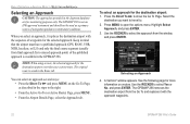
...the Approach tab. Select the destination you select an approach, it with the sequence of the published approach is available in the GPSMAP 296. Press MENU to show the Go To Page. See the following page for the destination airport overrides your current route. To select...want to travel to. 2. BASIC OPERATION IN AVIATION MODE > SELECTING AN APPROACH Selecting an Approach CAUTION: The approaches provided in the Jeppesen database are for the destination airport: 1. The GPSMAP 296 is saved in mind that the airport must have a published approach (GPS, RNAV, VOR, NDB, localizer, or ...
...the Approach tab. Select the destination you select an approach, it with the sequence of the published approach is available in the GPSMAP 296. Press MENU to show the Go To Page. See the following page for the destination airport overrides your current route. To select...want to travel to. 2. BASIC OPERATION IN AVIATION MODE > SELECTING AN APPROACH Selecting an Approach CAUTION: The approaches provided in the Jeppesen database are for the destination airport: 1. The GPSMAP 296 is saved in mind that the airport must have a published approach (GPS, RNAV, VOR, NDB, localizer, or ...
Pilot's Guide
Page 33
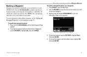
...and store in your present location: 1. Saving the selected item as a waypoint: 1. To mark your GPSMAP 296. Press PAGE to save the waypoint, use the ROCKER to open the GPS tab to create a new waypoint. For more information about editing waypoints, see the "Editing and Managing ..."), use the ROCKER to mark your satellite receiver status. Press MENU twice and open the Information Page for the map item. Press the ENTER/MARK to capture your present location to view your location. GPSMAP 296 Pilot's Guide 25 BASIC OPERATION IN AVIATION MODE > MARKING A WAYPOINT To mark a...
...and store in your present location: 1. Saving the selected item as a waypoint: 1. To mark your GPSMAP 296. Press PAGE to save the waypoint, use the ROCKER to open the GPS tab to create a new waypoint. For more information about editing waypoints, see the "Editing and Managing ..."), use the ROCKER to mark your satellite receiver status. Press MENU twice and open the Information Page for the map item. Press the ENTER/MARK to capture your present location to view your location. GPSMAP 296 Pilot's Guide 25 BASIC OPERATION IN AVIATION MODE > MARKING A WAYPOINT To mark a...
Pilot's Guide
Page 47
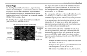
...Indicator (CDI) Ground speed Next waypoint and distance to it Turn Rate Indicator Estimated time enroute Panel Page Altitude Vertical speed CDI scale AVIATION MODE PAGES > PANEL PAGE The graphic HSI depicts the course to the course if you back to the destination or the next ...from that derived using GPS. The Panel Page appears only when the GPSMAP 296 is adjustable for Auto, ±0.25, 1.25 or 5.00 (nautical mile, statute mile, or kilometer) full-scale deflection. GPSMAP 296 Pilot's Guide 39 The course deviation scale setting is in Aviation Mode. The course pointer...
...Indicator (CDI) Ground speed Next waypoint and distance to it Turn Rate Indicator Estimated time enroute Panel Page Altitude Vertical speed CDI scale AVIATION MODE PAGES > PANEL PAGE The graphic HSI depicts the course to the course if you back to the destination or the next ...from that derived using GPS. The Panel Page appears only when the GPSMAP 296 is adjustable for Auto, ±0.25, 1.25 or 5.00 (nautical mile, statute mile, or kilometer) full-scale deflection. GPSMAP 296 Pilot's Guide 39 The course deviation scale setting is in Aviation Mode. The course pointer...

Pilot's Guide
Page 51
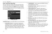
... PAGES > ACTIVE ROUTE PAGE Active Route Page Options Press MENU while on the Active Route Page to suit your route, based on existing GPS, RNAV, VOR, NDB, localizer, or ILS approach procedures. You can also change the data fields to open the Active Route Page. Active...options in Aviation or Marine Mode, the Active Route Page shows each point (waypoint or map item) of the active route, with the sequence of information. Active Route Page NOTE: If you to your current Usage Mode): Select Approach-(Aviation Only) allows you to open the options menu. GPSMAP 296 Pilot's Guide...
... PAGES > ACTIVE ROUTE PAGE Active Route Page Options Press MENU while on the Active Route Page to suit your route, based on existing GPS, RNAV, VOR, NDB, localizer, or ILS approach procedures. You can also change the data fields to open the Active Route Page. Active...options in Aviation or Marine Mode, the Active Route Page shows each point (waypoint or map item) of the active route, with the sequence of information. Active Route Page NOTE: If you to your current Usage Mode): Select Approach-(Aviation Only) allows you to open the options menu. GPSMAP 296 Pilot's Guide...

Pilot's Guide
Page 72
...-selectable data fields appear on the right side of the screen shows the GPS status or the route leg. The top of the screen that shows your routes does not include areas you press ROCKER, the GPSMAP 296 enters pan mode, which moves the map to page 28 through 35 in Marine... fields. The location marker (icon) that can also add additional data fields to customize the Map Page. 64 GPSMAP 296 Pilot's Guide Enter Custom Avoids so your travel on the map appear only if the map is a triangle symbol in the "Aviation Mode Pages and Features" section for the Map Page.
...-selectable data fields appear on the right side of the screen shows the GPS status or the route leg. The top of the screen that shows your routes does not include areas you press ROCKER, the GPSMAP 296 enters pan mode, which moves the map to page 28 through 35 in Marine... fields. The location marker (icon) that can also add additional data fields to customize the Map Page. 64 GPSMAP 296 Pilot's Guide Enter Custom Avoids so your travel on the map appear only if the map is a triangle symbol in the "Aviation Mode Pages and Features" section for the Map Page.
Pilot's Guide
Page 124
... data and sonar NMEA input support for the DPT, MTW, and VHW sentences. • Aviation In-the proprietary format used for connection to a Garmin panel-mounted GPS receiver. This eliminates the need to connect the GPSMAP 296 with a PC or another Garmin GPSMAP 296. When the USB is connected and the unit automatically switches to open the Com 1 and...
... data and sonar NMEA input support for the DPT, MTW, and VHW sentences. • Aviation In-the proprietary format used for connection to a Garmin panel-mounted GPS receiver. This eliminates the need to connect the GPSMAP 296 with a PC or another Garmin GPSMAP 296. When the USB is connected and the unit automatically switches to open the Com 1 and...
Pilot's Guide
Page 162
...Current Location 3 Finding an Item in Automotive or Marine Mode 53-55 Finding a Nearby Aviation Point 17-21 Fishing Information 106 Fish Symbols 125 Flasher 127 FlightBook 45, 146 Flight... your Flight Plan 27 Follow Roads 57 FSS 17 Fuel Flow 43, 46, 72 G GARMIN DGPS 116, 117 Getting Satellite Signals 4-6 Going to a Destination 51 Go To 14, ...GPS 139-140 Learning About 139 Off/On 5 Page 6, 69 GRI Chain 142 GSD 20 120 Guidance Tab 112 H Heading 115 Highways Avoid 112 Highway Page 108 Automotive Mode 65-66 Data Fields 66 Page Layout 66 Setup 66 HSI 39 Bug Indicator 33 Hunt & Fish Tab 106 GPSMAP 296...
...Current Location 3 Finding an Item in Automotive or Marine Mode 53-55 Finding a Nearby Aviation Point 17-21 Fishing Information 106 Fish Symbols 125 Flasher 127 FlightBook 45, 146 Flight... your Flight Plan 27 Follow Roads 57 FSS 17 Fuel Flow 43, 46, 72 G GARMIN DGPS 116, 117 Getting Satellite Signals 4-6 Going to a Destination 51 Go To 14, ...GPS 139-140 Learning About 139 Off/On 5 Page 6, 69 GRI Chain 142 GSD 20 120 Guidance Tab 112 H Heading 115 Highways Avoid 112 Highway Page 108 Automotive Mode 65-66 Data Fields 66 Page Layout 66 Setup 66 HSI 39 Bug Indicator 33 Hunt & Fish Tab 106 GPSMAP 296...
Pilot's Guide
Page 163
...Off-Route Recalculation 112 Off Course 100 Off Road 111 On-Screen Button 8 Options Menu 9 Overzoom 29 P Page Layout 34 Page Sequence 86 Panel Page Aviation Mode 39-42 Panning the Map 28, 30 Pan Mode 28, 30 PC Interface Cable 136 Persistent Alarm 100 Plan Flight 43, 72, 102 INDEX...Location Format 114, 143 Locked Route 26 Log Filter 107 Longitude 149 LORAN TD Setup 141-142 Lost Satellite Reception 5 GPSMAP 296 Pilot's Guide M Magnetic Variation 115 Main Menu Display Tab 108 GPS tab 4 Sound Tab 109 Managing Routes 69 Managing Tracks 82 Managing Waypoints 73 Man OverBoard 87 Map Information 35, 55...
...Off-Route Recalculation 112 Off Course 100 Off Road 111 On-Screen Button 8 Options Menu 9 Overzoom 29 P Page Layout 34 Page Sequence 86 Panel Page Aviation Mode 39-42 Panning the Map 28, 30 Pan Mode 28, 30 PC Interface Cable 136 Persistent Alarm 100 Plan Flight 43, 72, 102 INDEX...Location Format 114, 143 Locked Route 26 Log Filter 107 Longitude 149 LORAN TD Setup 141-142 Lost Satellite Reception 5 GPSMAP 296 Pilot's Guide M Magnetic Variation 115 Main Menu Display Tab 108 GPS tab 4 Sound Tab 109 Managing Routes 69 Managing Tracks 82 Managing Waypoints 73 Man OverBoard 87 Map Information 35, 55...


