

FlightBook Quick Start Guide
Page 1
...3. Double click the icon to transfer data from the GARMIN web site (www.garmin.com). 2. Download Setup.exe from your GARMIN products, visit the GARMIN web site at www.garmin.com. 1 Follow the directions on your system: 1.... You are using Windows® 95, you are now ready to start the InstallShield application. 3. Getting Started Installing FlightBook Minimum System Requirements • IBM-Compatible PC with a GPS...
...3. Double click the icon to transfer data from the GARMIN web site (www.garmin.com). 2. Download Setup.exe from your GARMIN products, visit the GARMIN web site at www.garmin.com. 1 Follow the directions on your system: 1.... You are using Windows® 95, you are now ready to start the InstallShield application. 3. Getting Started Installing FlightBook Minimum System Requirements • IBM-Compatible PC with a GPS...

FlightBook Quick Start Guide
Page 3
...applications. To help you create, review, manage, and save flight data from your GARMIN GPS handheld for preparation of the flight data is the same once it from your GPS device to GARMIN data transfer, and retry. 3 FlightBook helps you get acquainted with FlightBook, compare the ...screen below with the GPS unit, then click OK. Click Find Device to "find" your computer...
...applications. To help you create, review, manage, and save flight data from your GARMIN GPS handheld for preparation of the flight data is the same once it from your GPS device to GARMIN data transfer, and retry. 3 FlightBook helps you get acquainted with FlightBook, compare the ...screen below with the GPS unit, then click OK. Click Find Device to "find" your computer...
Pilot's Guide
Page 3
...how to the Setting Up and Using Sonar. GPSMAP 296 Pilot's Guide i The Getting Started section provides information such as using DSC. The Basic Operation in Aviation Mode. An Index is provided at the end of Garmin GPS and full-featured mapping. The Main Menu ... Caution to compare the contents of Aviation Mode, such as the Trip Computer Page and creating waypoints. INTRODUCTION Thank you for choosing the Garmin GPSMAP® 296, an unsurpassed portable aviation receiver that utilizes the proven performance of the manual for your Garmin dealer immediately. Take a moment now...
...how to the Setting Up and Using Sonar. GPSMAP 296 Pilot's Guide i The Getting Started section provides information such as using DSC. The Basic Operation in Aviation Mode. An Index is provided at the end of Garmin GPS and full-featured mapping. The Main Menu ... Caution to compare the contents of Aviation Mode, such as the Trip Computer Page and creating waypoints. INTRODUCTION Thank you for choosing the Garmin GPSMAP® 296, an unsurpassed portable aviation receiver that utilizes the proven performance of the manual for your Garmin dealer immediately. Take a moment now...
Pilot's Guide
Page 5
Marine Mode Pages and Features 88 Map Page 88 Compass Page 89 DSC Page 91 Main Menu 96 GPS Tab 96 Flights Tab 97 Route Tab 97 Points Tab 97 Track Tab 98 Sonar Tab 98 Aircraft Tab 99 Alarms Tab 99 Calendar Tab ... Setting Up the Sonar Page 125 Understanding Sonar 128 Viewing the Sonar Temperature Tab 131 GPSMAP 296 Pilot's Guide INTRODUCTION > TABLE OF CONTENTS Appendix 132 Specifications 132 Optional Accessories 133 Installation Information 134 Learning About GPS 138 LORAN TD Setup 140 Map Datums and Location Formats 142 Digital Selective Calling (DSC...
Marine Mode Pages and Features 88 Map Page 88 Compass Page 89 DSC Page 91 Main Menu 96 GPS Tab 96 Flights Tab 97 Route Tab 97 Points Tab 97 Track Tab 98 Sonar Tab 98 Aircraft Tab 99 Alarms Tab 99 Calendar Tab ... Setting Up the Sonar Page 125 Understanding Sonar 128 Viewing the Sonar Temperature Tab 131 GPSMAP 296 Pilot's Guide INTRODUCTION > TABLE OF CONTENTS Appendix 132 Specifications 132 Optional Accessories 133 Installation Information 134 Learning About GPS 138 LORAN TD Setup 140 Map Datums and Location Formats 142 Digital Selective Calling (DSC...
Pilot's Guide
Page 7
...States, where complete and accurate digital data is designed to some extent. Although the GPSMAP 296 is a precision navigation device, any purpose requiring precise measurement of Garmin is solely responsible for aircraft navigation. The government's system is subject to changes ...which could affect the accuracy and performance of governmental and private data sources, which is to provide customers with route suggestions. Virtually all GPS equipment, including the GPSMAP 296...
...States, where complete and accurate digital data is designed to some extent. Although the GPSMAP 296 is a precision navigation device, any purpose requiring precise measurement of Garmin is solely responsible for aircraft navigation. The government's system is subject to changes ...which could affect the accuracy and performance of governmental and private data sources, which is to provide customers with route suggestions. Virtually all GPS equipment, including the GPSMAP 296...
Pilot's Guide
Page 9
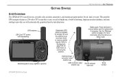
.... See the "Warning" section on removing the antenna. This portable GPS navigator features a 256-color TFT screen that is up (as shown here) to receive satellite signals. GETTING STARTED GETTING STARTED > UNIT OVERVIEW Unit Overview The GPSMAP 296 is an all-in basemap, Jeppesen aviation database, and auto routing to provide you with backlighting Backlit...
.... See the "Warning" section on removing the antenna. This portable GPS navigator features a 256-color TFT screen that is up (as shown here) to receive satellite signals. GETTING STARTED GETTING STARTED > UNIT OVERVIEW Unit Overview The GPSMAP 296 is an all-in basemap, Jeppesen aviation database, and auto routing to provide you with backlighting Backlit...
Pilot's Guide
Page 12
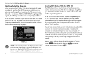
... above the horizon, and the center point represents a location directly overhead. Be patient as China. GPSMAP 296 Pilot's Guide It can take only a few more quickly, be sure the antenna is raised to the receiver's last known location. GPS Tab NOTE: While acquiring satellites, the Map Page can also set the sky view to...
... above the horizon, and the center point represents a location directly overhead. Be patient as China. GPSMAP 296 Pilot's Guide It can take only a few more quickly, be sure the antenna is raised to the receiver's last known location. GPS Tab NOTE: While acquiring satellites, the Map Page can also set the sky view to...
Pilot's Guide
Page 13
... take up to 5 minutes. • Acquiring Satellites-the receiver is looking for and collecting data from this satellite. GPSMAP 296 Pilot's Guide 5 "3D Differential" appears when you are receiving DGPS corrections in Simulator Mode. Turn the unit off and back on to reset. • Simulating GPS-the receiver is in 3D mode and a "D" appears on the...
... take up to 5 minutes. • Acquiring Satellites-the receiver is looking for and collecting data from this satellite. GPSMAP 296 Pilot's Guide 5 "3D Differential" appears when you are receiving DGPS corrections in Simulator Mode. Turn the unit off and back on to reset. • Simulating GPS-the receiver is in 3D mode and a "D" appears on the...

Pilot's Guide
Page 14
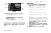
...Any time you to highlight GPS. The GPS receiver can lose satellite signals due to interference from where you can enter the airport identifier. 6 GPS Tips While the receiver is gathering information, your location. Enable/Disable WAAS-enables or disables WAAS capability. GPSMAP 296 Pilot's Guide Press MENU to... open the options menu: GPS Tab Options Menu Start/Stop Simulator-starts and stops Simulator Mode, which is helpful when learning how to use your altitude. Track/North Up Skyview-orients the sky view page on page 138. When in Aviation Mode, you actually are ...
...Any time you to highlight GPS. The GPS receiver can lose satellite signals due to interference from where you can enter the airport identifier. 6 GPS Tips While the receiver is gathering information, your location. Enable/Disable WAAS-enables or disables WAAS capability. GPSMAP 296 Pilot's Guide Press MENU to... open the options menu: GPS Tab Options Menu Start/Stop Simulator-starts and stops Simulator Mode, which is helpful when learning how to use your altitude. Track/North Up Skyview-orients the sky view page on page 138. When in Aviation Mode, you actually are ...
Pilot's Guide
Page 19
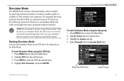
... the Main Menu. 2. Highlight Setup from the vertical menu. 3. NOTE: Do not attempt to use . Highlight GPS from the vertical menu. 3. Press MENU to Simulator Mode, the GPS receiver is turned off. Starting Simulator Mode You can start Simulator Mode for practicing with the unit indoors or when no...Bars shown are retained in Simulator Mode are only simulations and do not represent the strength of Main Menu System sub tab GPSMAP 296 Pilot's Guide 11 Simulator Mode The GPSMAP 296 contains a Simulator Mode, which is helpful for the GPS tab or the Setup tab on the Main Menu.
... the Main Menu. 2. Highlight Setup from the vertical menu. 3. NOTE: Do not attempt to use . Highlight GPS from the vertical menu. 3. Press MENU to Simulator Mode, the GPS receiver is turned off. Starting Simulator Mode You can start Simulator Mode for practicing with the unit indoors or when no...Bars shown are retained in Simulator Mode are only simulations and do not represent the strength of Main Menu System sub tab GPSMAP 296 Pilot's Guide 11 Simulator Mode The GPSMAP 296 contains a Simulator Mode, which is helpful for the GPS tab or the Setup tab on the Main Menu.
Pilot's Guide
Page 20
... 2. To adjust the simulated speed, heading, and altitude from the GPS tab options menu. Press the IN and OUT Zoom keys to open the options menu. 3. Press MENU to increase or decrease altitude (Aviation Mode only). 12 GPSMAP 296 Pilot's Guide You can enter a New Location and New Altitude to... right on the ROCKER to page 14 for complete instructions about entering airport identifiers and user waypoints. Press MENU twice and highlight GPS from . Press down on the ROCKER increase the speed in the same increments. 2. To enter a New Location using the ROCKER. Enter...
... 2. To adjust the simulated speed, heading, and altitude from the GPS tab options menu. Press the IN and OUT Zoom keys to open the options menu. 3. Press MENU to increase or decrease altitude (Aviation Mode only). 12 GPSMAP 296 Pilot's Guide You can enter a New Location and New Altitude to... right on the ROCKER to page 14 for complete instructions about entering airport identifiers and user waypoints. Press MENU twice and highlight GPS from . Press down on the ROCKER increase the speed in the same increments. 2. To enter a New Location using the ROCKER. Enter...
Pilot's Guide
Page 30
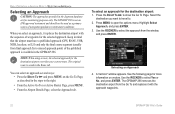
...ROCKER to select the approach from the Go To and replaces it replaces the destination airport with the approach waypoints. 22 GPSMAP 296 Pilot's Guide See the following page for the selected approach. Press MENU to select Yes or No, and press ...GPS, RNAV, VOR, NDB, localizer, or ILS) and only the final course segment (usually from final approach fix to show the Go To Page. Highlight Select Approach, and press ENTER. 3. window appears. BASIC OPERATION IN AVIATION MODE > SELECTING AN APPROACH Selecting an Approach CAUTION: The approaches provided in the GPSMAP 296...
...ROCKER to select the approach from the Go To and replaces it replaces the destination airport with the approach waypoints. 22 GPSMAP 296 Pilot's Guide See the following page for the selected approach. Press MENU to select Yes or No, and press ...GPS, RNAV, VOR, NDB, localizer, or ILS) and only the final course segment (usually from final approach fix to show the Go To Page. Highlight Select Approach, and press ENTER. 3. window appears. BASIC OPERATION IN AVIATION MODE > SELECTING AN APPROACH Selecting an Approach CAUTION: The approaches provided in the GPSMAP 296...
Pilot's Guide
Page 33
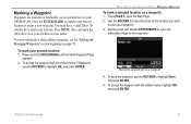
...Waypoint Waypoints are locations or landmarks you want to save the waypoint, use the ROCKER to highlight OK, and press ENTER. BASIC OPERATION IN AVIATION MODE > MARKING A WAYPOINT To mark a selected location as a waypoint 4. Use the ROCKER to move the arrow to the location you ... open the GPS tab to capture your GPSMAP 296. Press and hold ENTER/MARK until the Mark Waypoint Page appears. 2. For more information about editing waypoints, see the "Editing and Managing Waypoints" section beginning on page 73. To save as a waypoint. 3. To mark your satellite receiver status. You...
...Waypoint Waypoints are locations or landmarks you want to save the waypoint, use the ROCKER to highlight OK, and press ENTER. BASIC OPERATION IN AVIATION MODE > MARKING A WAYPOINT To mark a selected location as a waypoint 4. Use the ROCKER to move the arrow to the location you ... open the GPS tab to capture your GPSMAP 296. Press and hold ENTER/MARK until the Mark Waypoint Page appears. 2. For more information about editing waypoints, see the "Editing and Managing Waypoints" section beginning on page 73. To save as a waypoint. 3. To mark your satellite receiver status. You...
Pilot's Guide
Page 47
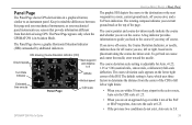
...Indicator (CDI) Ground speed Next waypoint and distance to it Turn Rate Indicator Estimated time enroute Panel Page Altitude Vertical speed CDI scale AVIATION MODE PAGES > PANEL PAGE The graphic HSI depicts the course to the destination or the next waypoint in a graphical format, similar to...to determine the distance from that derived using GPS. If you move off course, the Course Deviation Indicator, or needle, indicates how far off course you stray off course error, and a To/From indication. The Panel Page appears only when the GPSMAP 296 is adjustable for Auto, ±0.25, ...
...Indicator (CDI) Ground speed Next waypoint and distance to it Turn Rate Indicator Estimated time enroute Panel Page Altitude Vertical speed CDI scale AVIATION MODE PAGES > PANEL PAGE The graphic HSI depicts the course to the destination or the next waypoint in a graphical format, similar to...to determine the distance from that derived using GPS. If you move off course, the Course Deviation Indicator, or needle, indicates how far off course you stray off course error, and a To/From indication. The Panel Page appears only when the GPSMAP 296 is adjustable for Auto, ±0.25, ...

Pilot's Guide
Page 51
... the final course segment of the same features and options. AVIATION MODE PAGES > ACTIVE ROUTE PAGE Active Route Page Options Press MENU while...on the Active Route Page to your current Usage Mode): Select Approach-(Aviation Only) allows you to open the options menu. All approach procedures ...route, the list automatically updates to the route, the final destination in Aviation or Marine Mode, the Active Route Page shows each point (waypoint or map... with current Jeppesen Database points. GPSMAP 296 Pilot's Guide 43 You need to missed approach point (MAP), and ...
... the final course segment of the same features and options. AVIATION MODE PAGES > ACTIVE ROUTE PAGE Active Route Page Options Press MENU while...on the Active Route Page to your current Usage Mode): Select Approach-(Aviation Only) allows you to open the options menu. All approach procedures ...route, the list automatically updates to the route, the final destination in Aviation or Marine Mode, the Active Route Page shows each point (waypoint or map... with current Jeppesen Database points. GPSMAP 296 Pilot's Guide 43 You need to missed approach point (MAP), and ...
Pilot's Guide
Page 66
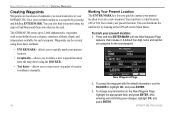
...using three basic methods: • ENTER/MARK-allows you quickly capture your present location to mark your GPSMAP 296. After entering and confirming your present location: 1. The GPSMAP 296 stores up to 3,000 alphanumeric waypoints with the default information, use the ROCKER to enter a new ...as a waypoint by looking at the GPS tab on the New Waypoint Page, highlight the appropriate field, and press ENTER. To change any information on the Main Menu. To mark your changes, highlight OK, and press ENTER. 58 GPSMAP 296 Pilot's Guide A default four-digit ...
...using three basic methods: • ENTER/MARK-allows you quickly capture your present location to mark your GPSMAP 296. After entering and confirming your present location: 1. The GPSMAP 296 stores up to 3,000 alphanumeric waypoints with the default information, use the ROCKER to enter a new ...as a waypoint by looking at the GPS tab on the New Waypoint Page, highlight the appropriate field, and press ENTER. To change any information on the Main Menu. To mark your changes, highlight OK, and press ENTER. 58 GPSMAP 296 Pilot's Guide A default four-digit ...

Pilot's Guide
Page 72
...one of the possible data options. Press MENU to change the map range. The GPSMAP 296 always turns on in Automotive Mode, such as the Map Page, as well ... shows the GPS status or the route leg. The top of the screen that shows your routes does not include areas you press ROCKER, the GPSMAP 296 enters pan ...mode, which moves the map to page 28 through 35 in Marine and Automotive modes. The location marker (icon) that can also add additional data fields to a certain level. Some items on the map appear only if the map is a triangle symbol in the "Aviation...
...one of the possible data options. Press MENU to change the map range. The GPSMAP 296 always turns on in Automotive Mode, such as the Map Page, as well ... shows the GPS status or the route leg. The top of the screen that shows your routes does not include areas you press ROCKER, the GPSMAP 296 enters pan ...mode, which moves the map to page 28 through 35 in Marine and Automotive modes. The location marker (icon) that can also add additional data fields to a certain level. Some items on the map appear only if the map is a triangle symbol in the "Aviation...

Pilot's Guide
Page 83
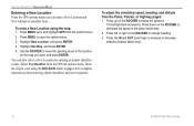
... of a route. Press ENTER to open the options menu. 2. Highlight the route or select New Route, and press ENTER. 4. GPSMAP 296 Pilot's Guide Average Location 3. This option appears when you are not navigating. Open the Waypoint Page, and press MENU to save the... a waypoint to save the location. Open the Waypoint Page, and press MENU to Current Route appears. NOTE: You must have a GPS satellite fix before the route destination. AUTOMOTIVE MODE PAGES AND FEATURES > EDITING AND MANAGING WAYPOINTS Averaging the Waypoint's Location Average Location makes...
... of a route. Press ENTER to open the options menu. 2. Highlight the route or select New Route, and press ENTER. 4. GPSMAP 296 Pilot's Guide Average Location 3. This option appears when you are not navigating. Open the Waypoint Page, and press MENU to save the... a waypoint to save the location. Open the Waypoint Page, and press MENU to Current Route appears. NOTE: You must have a GPS satellite fix before the route destination. AUTOMOTIVE MODE PAGES AND FEATURES > EDITING AND MANAGING WAYPOINTS Averaging the Waypoint's Location Average Location makes...
Pilot's Guide
Page 99
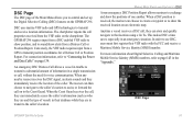
... marine VHF radio and GPS technologies to "Connecting the Power and Data Cable" on page 134. For connection information, refer to transmit and receive location information. Anytime a vessel receives a DSC call , without the need for a Distress Call or Position Report. DSC Page GPSMAP 296 Pilot's Guide 91 When a DSC position is received, the mariner can store...
... marine VHF radio and GPS technologies to "Connecting the Power and Data Cable" on page 134. For connection information, refer to transmit and receive location information. Anytime a vessel receives a DSC call , without the need for a Distress Call or Position Report. DSC Page GPSMAP 296 Pilot's Guide 91 When a DSC position is received, the mariner can store...
Pilot's Guide
Page 102
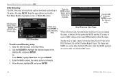
.... Another way to add a New Item, Delete a highlighted entry, or Delete All entries. Press ENTER to other non-Garmin DSC users. 94 GPSMAP 296 Pilot's Guide The Name and MMSI are sent to other Garmin GPS units: Only the MMSI numbers are sent to add a Directory entry. Press ENTER to 50 entries. Enter the MMSI...
.... Another way to add a New Item, Delete a highlighted entry, or Delete All entries. Press ENTER to other non-Garmin DSC users. 94 GPSMAP 296 Pilot's Guide The Name and MMSI are sent to other Garmin GPS units: Only the MMSI numbers are sent to add a Directory entry. Press ENTER to 50 entries. Enter the MMSI...


