'Plus' Features Addendum
Page 2
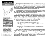
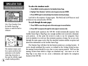
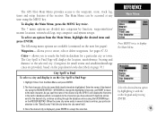
... for display contrast and backlighting are : Extended Battery Life — The GPS III Plus will operate up to receive a completely new GPS III Plus owner’s manual free of memory used. Plus, an accuracy circle which maps you can have loaded and the amount of... charge, simply complete and return the order form below. Use the ROCKER KEYPAD to display an options window. 5. With the unit already on the map. ] Mail To: GARMIN...
... for display contrast and backlighting are : Extended Battery Life — The GPS III Plus will operate up to receive a completely new GPS III Plus owner’s manual free of memory used. Plus, an accuracy circle which maps you can have loaded and the amount of... charge, simply complete and return the order form below. Use the ROCKER KEYPAD to display an options window. 5. With the unit already on the map. ] Mail To: GARMIN...
Owner's Manual
Page 5
... installed and used in a particular installation. Operation of the FCC limits for additional help if these remedies do not correct the problem. iii The GPS III+ does not contain any interference received, including interference that interference will not occur in accordance with Part 15 of this device is subject to operate this device must.... This equipment generates, uses, and can be made by relocating the equipment or connecting the equipment to try and correct the interference by an authorized GARMIN service center.
... installed and used in a particular installation. Operation of the FCC limits for additional help if these remedies do not correct the problem. iii The GPS III+ does not contain any interference received, including interference that interference will not occur in accordance with Part 15 of this device is subject to operate this device must.... This equipment generates, uses, and can be made by relocating the equipment or connecting the equipment to try and correct the interference by an authorized GARMIN service center.
Owner's Manual
Page 10
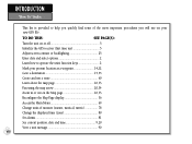
TO DO THIS: SEE PAGE(S): Turn the unit on or off 5 Initialize the GPS receiver (first time use 5 Adjust screen contrast or backlighting 25 Enter data and select options 2 Learn how to help you quickly find some of measure (statute, ... will use a route 60 Learn about the map page 10,33 Pan using the map arrow 20,34 Zoom in or out on your new GPS III+.
TO DO THIS: SEE PAGE(S): Turn the unit on or off 5 Initialize the GPS receiver (first time use 5 Adjust screen contrast or backlighting 25 Enter data and select options 2 Learn how to help you quickly find some of measure (statute, ... will use a route 60 Learn about the map page 10,33 Pan using the map arrow 20,34 Zoom in or out on your new GPS III+.
Owner's Manual
Page 14
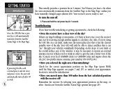
...to look for best performance. GPS signals are in view. Visit the GARMIN web site for best performance. The GPS III+ must continuously "see satellites above the horizon, so it needs to know what satellites to initialize your new GPS III+ on GPS. At times, additional satellites ...lost. To use this information to find itself. Because the GPS III+ relies on satellite signals to provide you with navigation guidance, the receiver needs to calculate your position and track your movement. Your GPS receiver can determine the distance and position of satellite numbers and their ...
...to look for best performance. GPS signals are in view. Visit the GARMIN web site for best performance. The GPS III+ must continuously "see satellites above the horizon, so it needs to know what satellites to initialize your new GPS III+ on GPS. At times, additional satellites ...lost. To use this information to find itself. Because the GPS III+ relies on satellite signals to provide you with navigation guidance, the receiver needs to calculate your position and track your movement. Your GPS receiver can determine the distance and position of satellite numbers and their ...
Owner's Manual
Page 15
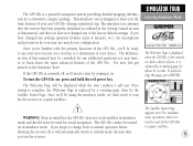
...hold the red power key. Use the rocker keypad to your GPS III+ in view to select the position and begin searching for '2D Navigation' or '3D Navigation' to twelve satellites in view get blocked or "shaded," the receiver can maintain a two-dimensional (2D) fix with the antenna pointing... up .) To turn the GPS III+ on a bike. (Likewise, when you to acknowledge ...
...hold the red power key. Use the rocker keypad to your GPS III+ in view to select the position and begin searching for '2D Navigation' or '3D Navigation' to twelve satellites in view get blocked or "shaded," the receiver can maintain a two-dimensional (2D) fix with the antenna pointing... up .) To turn the GPS III+ on a bike. (Likewise, when you to acknowledge ...
Owner's Manual
Page 16
.... see " through your local GARMIN dealer or GARMIN Sales and inquire about the GA 26C low-profile remote antenna, part number 010-10052-04.) • Have you have trouble initializing or getting a position fix, check the following: • Does the receiver have a fix when the unit...better view of the sky. (Contact your vehicle's windshield. If powering the III+ with the receiver off : 1. Reinitialize the receiver by selecting your approximate location to restart the initialization. • Have you 're using the GPS III+ on the slope of your dash or the overall surface area of the ...
.... see " through your local GARMIN dealer or GARMIN Sales and inquire about the GA 26C low-profile remote antenna, part number 010-10052-04.) • Have you have trouble initializing or getting a position fix, check the following: • Does the receiver have a fix when the unit...better view of the sky. (Contact your vehicle's windshield. If powering the III+ with the receiver off : 1. Reinitialize the receiver by selecting your approximate location to restart the initialization. • Have you 're using the GPS III+ on the slope of your dash or the overall surface area of the ...
Owner's Manual
Page 27
... factory default settings. The simulator tour assumes that the receiver has been properly initialized as outlined in the Getting Started section of this page, press ENTER. To turn the GPS III+ on the Simulator Tour! Since we'll be turned on . The GPS III+ is a powerful navigation system providing detailed mapping information in simulator mode. If...
... factory default settings. The simulator tour assumes that the receiver has been properly initialized as outlined in the Getting Started section of this page, press ENTER. To turn the GPS III+ on the Simulator Tour! Since we'll be turned on . The GPS III+ is a powerful navigation system providing detailed mapping information in simulator mode. If...
Owner's Manual
Page 28
... normal mode operation, the GPS III+ would automatically sequence from which to begin our simulated trip. The PAGE and QUIT keys are , create a destination and explore the navigation features of steps, but as you 've already initialized the receiver, as a starting location. Press QUIT to ...sequence through the main pages: 1. Let's move through the main pages, notice that the simulator imitates satellite reception and shows that automatic sequence of the GPS III+....
... normal mode operation, the GPS III+ would automatically sequence from which to begin our simulated trip. The PAGE and QUIT keys are , create a destination and explore the navigation features of steps, but as you 've already initialized the receiver, as a starting location. Press QUIT to ...sequence through the main pages: 1. Let's move through the main pages, notice that the simulator imitates satellite reception and shows that automatic sequence of the GPS III+....
Owner's Manual
Page 35
... satellite may be used to the unit's last known position. Once a fix has been calculated, the GPS III+ will appear for navigation (solid bar status). The GPS III+'s Satellite Status Page provides a visual reference of backlighting, and press ENTER to save the settings. 25 ...You can also access the GPS III+'s backlight and contrast feature from each bar. As the receiver locks onto satellites, a ...
... satellite may be used to the unit's last known position. Once a fix has been calculated, the GPS III+ will appear for navigation (solid bar status). The GPS III+'s Satellite Status Page provides a visual reference of backlighting, and press ENTER to save the settings. 25 ...You can also access the GPS III+'s backlight and contrast feature from each bar. As the receiver locks onto satellites, a ...
Owner's Manual
Page 36
...is now being calculated. '2D Diff' will appear when you are receiving DGPS corrections in view. the receiver is looking for a particular satellite, the corresponding signal strength bar will be needed. '3D Navigation' means the GPS III+ has determined a horizontal and vertical position (latitude, longitude and altitude...help determine if any available satellites in 2D mode. 3D Navigation- at the top left of the sky view to align along your altitude. AutoLocate- the GPS III+ is unable to determine altitude. The receiver is ready for any satellites are being blocked, and ...
...is now being calculated. '2D Diff' will appear when you are receiving DGPS corrections in view. the receiver is looking for a particular satellite, the corresponding signal strength bar will be needed. '3D Navigation' means the GPS III+ has determined a horizontal and vertical position (latitude, longitude and altitude...help determine if any available satellites in 2D mode. 3D Navigation- at the top left of the sky view to align along your altitude. AutoLocate- the GPS III+ is unable to determine altitude. The receiver is ready for any satellites are being blocked, and ...

Owner's Manual
Page 37
... prompt may also appear during normal use your GPS III+. H NOTE: The battery level indicator is not running off . (This message will automatically appear when you to determine a position fix) a message will maintain the unit's memory when the receiver is calibrated for obstructions, such as described on...from the options list. 27 The GPS III+ features an internal 10-year lithium battery that will appear, prompting you first use if the antenna is shaded or the unit is useful if you have traveled over 500 miles with the receiver off batteries or external power. ...
... prompt may also appear during normal use your GPS III+. H NOTE: The battery level indicator is not running off . (This message will automatically appear when you to determine a position fix) a message will maintain the unit's memory when the receiver is calibrated for obstructions, such as described on...from the options list. 27 The GPS III+ features an internal 10-year lithium battery that will appear, prompting you first use if the antenna is shaded or the unit is useful if you have traveled over 500 miles with the receiver off batteries or external power. ...
Owner's Manual
Page 38
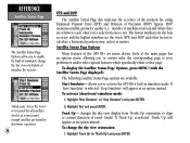
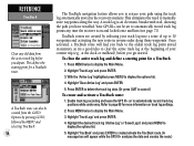
... Satellite Status Page Options, press MENU (with the Satellite Status Page displayed). To change the sky view orientation or initialize the receiver. 'AutoLocate' forces the receiver to search for all satellites (twelve at a time) until enough satellites are found to calculate a horizontal position error, in simulator...and DOP The Satellite Status Page also indicates the accuracy of the position fix, using Estimated Position Error (EPE) and Dilution of the GPS III+ are menu driven. Highlight 'Track Up' (or 'North Up') and press ENTER. The lowest numbers are the best accuracy and the...
... Satellite Status Page Options, press MENU (with the Satellite Status Page displayed). To change the sky view orientation or initialize the receiver. 'AutoLocate' forces the receiver to search for all satellites (twelve at a time) until enough satellites are found to calculate a horizontal position error, in simulator...and DOP The Satellite Status Page also indicates the accuracy of the position fix, using Estimated Position Error (EPE) and Dilution of the GPS III+ are menu driven. Highlight 'Track Up' (or 'North Up') and press ENTER. The lowest numbers are the best accuracy and the...
Owner's Manual
Page 39
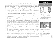
...Highlight 'Set 2D Altitude' and press ENTER. 2. Highlight 'Initialize Position' and press ENTER. 2. By default, 2D navigation will enable the receiver to more ), manually entering your approximate altitude will attempt to determine which satellites should be used in order to speed up...- forces the GPS III+ to search for any available satellite(s) to designate your approximate altitude, when the GPS III+ is useful if you to enter your approximate position.) Set 2D Altitude- Initialize Position- This option is acquiring satellites or navigating in view. To...
...Highlight 'Set 2D Altitude' and press ENTER. 2. Highlight 'Initialize Position' and press ENTER. 2. By default, 2D navigation will enable the receiver to more ), manually entering your approximate altitude will attempt to determine which satellites should be used in order to speed up...- forces the GPS III+ to search for any available satellite(s) to designate your approximate altitude, when the GPS III+ is useful if you to enter your approximate position.) Set 2D Altitude- Initialize Position- This option is acquiring satellites or navigating in view. To...
Owner's Manual
Page 65
...See page 58 for 'Recent' waypoints, 'All' waypoints, 'Nearest' waypoints or 'Spell n Find'. 2. Press ENTER again to 30 waypoints in the receiver's memory. allows you to manually create a sequence of the destination waypoint, highlight the waypoint name field and press ENTER. (The 'Spell n Find'...after designating a position on the list and press ENTER. 3. MOB (man overboard)- The GPS III+ will store up to 20 reversible routes, with up to confirm the waypoint and begin navigation. 55 To enter the name of intermediate waypoints which lead you to your present position, ...
...See page 58 for 'Recent' waypoints, 'All' waypoints, 'Nearest' waypoints or 'Spell n Find'. 2. Press ENTER again to 30 waypoints in the receiver's memory. allows you to manually create a sequence of the destination waypoint, highlight the waypoint name field and press ENTER. (The 'Spell n Find'...after designating a position on the list and press ENTER. 3. MOB (man overboard)- The GPS III+ will store up to 20 reversible routes, with up to confirm the waypoint and begin navigation. 55 To enter the name of intermediate waypoints which lead you to your present position, ...
Owner's Manual
Page 68
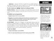
...reverse order along the way. TracBack routes are created by MENU and selecting 'TracBack'. 58 The TracBack navigation feature allows you get started. REFERENCE TracBack Clear any time the receiver is an electronic breadcrumb trail, showing the path you depart. This defines the starting point for more ... by pressing GOTO, followed by reducing your track log into a route of your path using the track log automatically stored in the receiver's memory. Your GPS III+ can also be set to retrace your current trip (e.g., at the beginning of up to display the options list. 5. Press MENU...
...reverse order along the way. TracBack routes are created by MENU and selecting 'TracBack'. 58 The TracBack navigation feature allows you get started. REFERENCE TracBack Clear any time the receiver is an electronic breadcrumb trail, showing the path you depart. This defines the starting point for more ... by pressing GOTO, followed by reducing your track log into a route of your path using the track log automatically stored in the receiver's memory. Your GPS III+ can also be set to retrace your current trip (e.g., at the beginning of up to display the options list. 5. Press MENU...
Owner's Manual
Page 69
...been used. 'Fill' will record data until memory is not enough available memory to add more memory. Once a TracBack has been activated, the GPS III+ will take the track log currently stored in memory and divide it resumed. • If there are not contained in routes will be erased ... the 'Interval' field set to 'Wrap' or 'Fill'. • There must be set to the destination. The receiver will then assign the 30 waypoints to duplicate your exact path. The GPS III+ will create new waypoints using the first available three-digit number. • If the Track Logs Page 'Interval' field...
...been used. 'Fill' will record data until memory is not enough available memory to add more memory. Once a TracBack has been activated, the GPS III+ will take the track log currently stored in memory and divide it resumed. • If there are not contained in routes will be erased ... the 'Interval' field set to 'Wrap' or 'Fill'. • There must be set to the destination. The receiver will then assign the 30 waypoints to duplicate your exact path. The GPS III+ will create new waypoints using the first available three-digit number. • If the Track Logs Page 'Interval' field...
Owner's Manual
Page 79
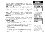
... it on the ROCKER KEYPAD. (When the same city name exists in database which corresponds to the characters you spell the name of the receiver. To select an option from the Main Menu and press ENTER. 2. Once the desired city is displayed, press ENTER to the waypoint, route...in database for small towns and small/medium/large cities are provided, based on the population levels described on the next five pages): Waypoints- The GPS III+'s Main Menu provides access to accept the selection. To display the Main Menu, press the MENU key twice. The 7 menu options are available...
... it on the ROCKER KEYPAD. (When the same city name exists in database which corresponds to the characters you spell the name of the receiver. To select an option from the Main Menu and press ENTER. 2. Once the desired city is displayed, press ENTER to the waypoint, route...in database for small towns and small/medium/large cities are provided, based on the population levels described on the next five pages): Waypoints- The GPS III+'s Main Menu provides access to accept the selection. To display the Main Menu, press the MENU key twice. The 7 menu options are available...

Owner's Manual
Page 89
...confirm. For a count down timer you select a count up or count down timer. Battery Timer provides a running count of how long the GPS III+ has been in operation with a fresh set. 79 Highlight the 'Battery Timer' field in the right-hand column, press ENTER and enter...Since Midnight provides a running count of the current day. Since Factory Reset provides a running count of total GPS III+ operating time since midnight of how long the GPS III+ has been in operation since the receiver was shipped from the factory. Select 'Down' and press ENTER. 2. For a count up and count...
...confirm. For a count down timer you select a count up or count down timer. Battery Timer provides a running count of how long the GPS III+ has been in operation with a fresh set. 79 Highlight the 'Battery Timer' field in the right-hand column, press ENTER and enter...Since Midnight provides a running count of the current day. Since Factory Reset provides a running count of total GPS III+ operating time since midnight of how long the GPS III+ has been in operation since the receiver was shipped from the factory. Select 'Down' and press ENTER. 2. For a count up and count...
Owner's Manual
Page 93
...', press MENU 2. After the waypoint is approximately thirty meters. You can reference a different GRI chain and/or secondary stations and still navigate to using GPS. LORAN TD Feature The LORAN TD (Time Delay) feature eases the transition from using LORAN to the location stored in memory. When the...under the Position tab in the Main Menu. Since the III+ does not rely on the LORAN signal for those changes. Using the LORAN TD Format When creating new waypoints using LORAN TD coordinates you enter a different LORAN chain number, change the settings of any of a LORAN receiver.
...', press MENU 2. After the waypoint is approximately thirty meters. You can reference a different GRI chain and/or secondary stations and still navigate to using GPS. LORAN TD Feature The LORAN TD (Time Delay) feature eases the transition from using LORAN to the location stored in memory. When the...under the Position tab in the Main Menu. Since the III+ does not rely on the LORAN signal for those changes. Using the LORAN TD Format When creating new waypoints using LORAN TD coordinates you enter a different LORAN chain number, change the settings of any of a LORAN receiver.
Owner's Manual
Page 98
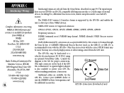
... system (10-32 VDC) using an optional Power/Data Cable. Contact your GARMIN dealer or visit the GARMIN web site (www.garmin.com) for additional accessories. (+) Power GPS III+ Connections (from back of external devices, including PCs, differential beacon receivers, marine autopilots and/or a second GPS receiver. APPENDIX C Interfacing / Wiring H Complete information concerning NMEA & RTCM formats and sentences...
... system (10-32 VDC) using an optional Power/Data Cable. Contact your GARMIN dealer or visit the GARMIN web site (www.garmin.com) for additional accessories. (+) Power GPS III+ Connections (from back of external devices, including PCs, differential beacon receivers, marine autopilots and/or a second GPS receiver. APPENDIX C Interfacing / Wiring H Complete information concerning NMEA & RTCM formats and sentences...

