Owner's Manual
Page 2
..., disseminated, downloaded or stored in Taiwan. Visit the GARMIN web site (www.garmin.com) for current updates and supplemental information concerning the use and operation of this and other electronic storage medium to be viewed for any person or organization of GARMIN Corporation. All rights reserved. GARMIN Corporation hereby grants permission to download a single copy of...
..., disseminated, downloaded or stored in Taiwan. Visit the GARMIN web site (www.garmin.com) for current updates and supplemental information concerning the use and operation of this and other electronic storage medium to be viewed for any person or organization of GARMIN Corporation. All rights reserved. GARMIN Corporation hereby grants permission to download a single copy of...
Owner's Manual
Page 7
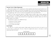
Serial Number: v Also, be sure to record your GARMIN GPS unit: • Notification of Product Updates • Notification of New Products • Lost or Stolen unit tracking Serial Number Use this area to record the serial number (8-digit number located on the back of your GPS III+ handy and connect to re-register using a mail-in...
Serial Number: v Also, be sure to record your GARMIN GPS unit: • Notification of Product Updates • Notification of New Products • Lost or Stolen unit tracking Serial Number Use this area to record the serial number (8-digit number located on the back of your GPS III+ handy and connect to re-register using a mail-in...
Owner's Manual
Page 15
... it can simply use your approximate location directly on the map. 5 To initialize the GPS III+, designate your GPS III+ in view to select the position and begin searching for '2D Navigation' or '3D Navigation' to twelve satellites in view get blocked or "shaded," the receiver can maintain a ...Press ENTER to update your approximate location (within 250 miles). The receiver will be replaced by a warning page, then by the Satellite Status Page. Press ENTER to position the cursor on the map display. Initializing Your GPS III+ To initialize the GPS III+, take the receiver...
... it can simply use your approximate location directly on the map. 5 To initialize the GPS III+, designate your GPS III+ in view to select the position and begin searching for '2D Navigation' or '3D Navigation' to twelve satellites in view get blocked or "shaded," the receiver can maintain a ...Press ENTER to update your approximate location (within 250 miles). The receiver will be replaced by a warning page, then by the Satellite Status Page. Press ENTER to position the cursor on the map display. Initializing Your GPS III+ To initialize the GPS III+, take the receiver...
Owner's Manual
Page 35
...receiver locks onto satellites, a signal strength bar will then update your position, track, and speed by selecting and using ...strength bars- the receiver has found the satellite(s) and is looking for navigation (solid bar status). Once a fix has been calculated, the GPS III+ will appear for use . Press UP or DOWN on the rocker ...of various receiver functions, including current satellite coverage, receiver operating mode, battery level and position accuracy. The GPS III+'s Satellite Status Page provides a visual reference of each one. the inner circle 45º above the ...
...receiver locks onto satellites, a signal strength bar will then update your position, track, and speed by selecting and using ...strength bars- the receiver has found the satellite(s) and is looking for navigation (solid bar status). Once a fix has been calculated, the GPS III+ will appear for use . Press UP or DOWN on the rocker ...of various receiver functions, including current satellite coverage, receiver operating mode, battery level and position accuracy. The GPS III+'s Satellite Status Page provides a visual reference of each one. the inner circle 45º above the ...
Owner's Manual
Page 48
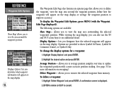
... for the selected item. 3. Scroll through the list using the UP/DOWN portion of travel. Press ENTER to the map pointer. The lists are continuously updated as outlined on the Waypoint Edit Page. Use the rocker keypad to move the cursor to Pntr' option will only be available when the pointer...
... for the selected item. 3. Scroll through the list using the UP/DOWN portion of travel. Press ENTER to the map pointer. The lists are continuously updated as outlined on the Waypoint Edit Page. Use the rocker keypad to move the cursor to Pntr' option will only be available when the pointer...
Owner's Manual
Page 62
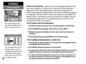
... Options' and press ENTER. 2. To delete a waypoint: 1. While viewing the map display, you to see additional detail. Average Position- ENTER to delete (or QUIT to update the waypoint's position with the Waypoint Edit Page displayed). allows you to average position samples over time to cancel).
... Options' and press ENTER. 2. To delete a waypoint: 1. While viewing the map display, you to see additional detail. Average Position- ENTER to delete (or QUIT to update the waypoint's position with the Waypoint Edit Page displayed). allows you to average position samples over time to cancel).
Owner's Manual
Page 63
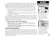
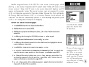
...the city, save it as a waypoint or switch between size and reference information as described on pages 35, 39-40 and 54) are continuously updated as described above) and highlight the desired location (Waypoint, City or Exit). 2. from the Main Menu. REFERENCE Nearest Locations To view the ... closest points of safety in an emergency. To view the nearest locations pages: 1. Press ENTER to each . 53 Another waypoint feature of the GPS III+ is displayed on the Waypoint Edit Page. The nearest locations pages are organized as outlined on pages 50-51. 4. For cities, the information ...
...the city, save it as a waypoint or switch between size and reference information as described on pages 35, 39-40 and 54) are continuously updated as described above) and highlight the desired location (Waypoint, City or Exit). 2. from the Main Menu. REFERENCE Nearest Locations To view the ... closest points of safety in an emergency. To view the nearest locations pages: 1. Press ENTER to each . 53 Another waypoint feature of the GPS III+ is displayed on the Waypoint Edit Page. The nearest locations pages are organized as outlined on pages 50-51. 4. For cities, the information ...

Owner's Manual
Page 76
...the active route, along the current route will show each route waypoint. There are ten different data items available. See page 95 for navigation guidance. To delete all stored routes will remain in the route is the Active Route Page. Press ENTER to each waypoint, fuel requirements... press the LEFT/RIGHT keys on the left -hand side of the screen. allows you navigate the route, the information on the Active Route Page will appear. 2. A confirmation page will automatically update to cancel). The next waypoint in memory, but not as part of any remaining interim ...
...the active route, along the current route will show each route waypoint. There are ten different data items available. See page 95 for navigation guidance. To delete all stored routes will remain in the route is the Active Route Page. Press ENTER to each waypoint, fuel requirements... press the LEFT/RIGHT keys on the left -hand side of the screen. allows you navigate the route, the information on the Active Route Page will appear. 2. A confirmation page will automatically update to cancel). The next waypoint in memory, but not as part of any remaining interim ...
Owner's Manual
Page 87
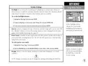
... prevent the backlighting from the 'System' settings. 77 This setting ensures accurate readings from 15 seconds to your GPS III+: Alkaline, Lithium or NiCad. Display orientation is suitable for most applications and offers position updates which adapt to 4 minutes (since last key press) are available. REFERENCE Setup Menu: System Set the 'Backlight' field...
... prevent the backlighting from the 'System' settings. 77 This setting ensures accurate readings from 15 seconds to your GPS III+: Alkaline, Lithium or NiCad. Display orientation is suitable for most applications and offers position updates which adapt to 4 minutes (since last key press) are available. REFERENCE Setup Menu: System Set the 'Backlight' field...

Owner's Manual
Page 88
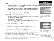
... is used in the 'Heading' field, highlight the heading reference field (immediately to the right) and press ENTER. Failure to update this setting, the GPS III+ will not automatically calculate and update the magnetic variation at your position changes. You can select from 'Auto Mag Var', 'True', 'Grid' and 'User Mag ... 'Nautical', 'Statute' or 'Metric' terms. Heading lets you select the reference used in substantial differences between the information displayed on your GPS III+ and external references, such as your current position using the rocker keypad and press ENTER.
... is used in the 'Heading' field, highlight the heading reference field (immediately to the right) and press ENTER. Failure to update this setting, the GPS III+ will not automatically calculate and update the magnetic variation at your position changes. You can select from 'Auto Mag Var', 'True', 'Grid' and 'User Mag ... 'Nautical', 'Statute' or 'Metric' terms. Heading lets you select the reference used in substantial differences between the information displayed on your GPS III+ and external references, such as your current position using the rocker keypad and press ENTER.
Owner's Manual
Page 95
...to highlight the 'Tuning Mode' field and press ENTER/MARK. 2. REFERENCE Setup Menu: DGPS The III+ can automatically tune the GARMIN GBR 21 or GBR 23. To restart the scan: 1. With the unit set to 'Garmin DGPS' or 'RTCM/NMEA', use a frequency from the DGPS site. The DGPS beacon transmitters ... for their web site at 6-second intervals. Press MENU to restart the scan. 'View Beacon Log' allows you to find the most updated list of the following: • Tuning- To have the unit automatically scan for operation. • Check Wiring- Highlight 'Scan' and press ENTER/MARK...
...to highlight the 'Tuning Mode' field and press ENTER/MARK. 2. REFERENCE Setup Menu: DGPS The III+ can automatically tune the GARMIN GBR 21 or GBR 23. To restart the scan: 1. With the unit set to 'Garmin DGPS' or 'RTCM/NMEA', use a frequency from the DGPS site. The DGPS beacon transmitters ... for their web site at 6-second intervals. Press MENU to restart the scan. 'View Beacon Log' allows you to find the most updated list of the following: • Tuning- To have the unit automatically scan for operation. • Check Wiring- Highlight 'Scan' and press ENTER/MARK...
Owner's Manual
Page 97
...may cause injury or void your GARMIN dealer or GARMIN Customer Service. The GPS III+ has no user-serviceable Specifications parts. The GPS III+ is constructed of high-quality materials and should not require user APPENDIX B maintenance. To protect your GPS III+, keep it in its carrying case... PhaseTrac12™ Acquisition Time: Approx. 15 seconds (warm start) Approx. 45 seconds (EZinit/cold start) Approx. 5 minutes (AutoLocate™) Update Rate: 1/second, continuous Position Accuracy: 3-5 meters (10-16 ft) with DGPS corrections, 95% typical* Input: Four 1.5-volt AA batteries&#...
...may cause injury or void your GARMIN dealer or GARMIN Customer Service. The GPS III+ has no user-serviceable Specifications parts. The GPS III+ is constructed of high-quality materials and should not require user APPENDIX B maintenance. To protect your GPS III+, keep it in its carrying case... PhaseTrac12™ Acquisition Time: Approx. 15 seconds (warm start) Approx. 45 seconds (EZinit/cold start) Approx. 5 minutes (AutoLocate™) Update Rate: 1/second, continuous Position Accuracy: 3-5 meters (10-16 ft) with DGPS corrections, 95% typical* Input: Four 1.5-volt AA batteries&#...


