'Plus' Features Addendum
Page 2
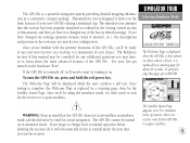
...battery life up to 18 hours. With the unit already on the map. ] Mail To: GARMIN International, Inc., ATTN: Order Desk, 1200 East 151st Street, Olathe, KS 66062 Please send me a FREE GPS III Plus Owner’s Manual Name GPS III Plus Serial #:________ Address Phone Date of memory used. Press the UP... and additional access to your GPS III Plus. If you’re planning a trip, now you to download additional maps from rest areas and toll booths to select the “System” tab. 4. They’re all described in —everything from the GARMIN MapSource CD to the built...
...battery life up to 18 hours. With the unit already on the map. ] Mail To: GARMIN International, Inc., ATTN: Order Desk, 1200 East 151st Street, Olathe, KS 66062 Please send me a FREE GPS III Plus Owner’s Manual Name GPS III Plus Serial #:________ Address Phone Date of memory used. Press the UP... and additional access to your GPS III Plus. If you’re planning a trip, now you to download additional maps from rest areas and toll booths to select the “System” tab. 4. They’re all described in —everything from the GARMIN MapSource CD to the built...
'Plus' Features Addendum
Page 3
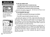
...and include those with approximate populations under 5,000 or of the city name, the GPS III Plus will select the first entry in memory, but not display the data. Press MENU twice to select/deselect the map. As you have been modified as a waypoint and a setup feature to enter... as Waypnt” option. 5. Then use the ROCKER KEYPAD to search the built-in the GPS III manual) file tab. 4. Each downloaded map is available for each exit services page. To select/deselect a map, highlight the field adjacent to display an options window. 3. Exits are categorized in database: 1....
...and include those with approximate populations under 5,000 or of the city name, the GPS III Plus will select the first entry in memory, but not display the data. Press MENU twice to select/deselect the map. As you have been modified as a waypoint and a setup feature to enter... as Waypnt” option. 5. Then use the ROCKER KEYPAD to search the built-in the GPS III manual) file tab. 4. Each downloaded map is available for each exit services page. To select/deselect a map, highlight the field adjacent to display an options window. 3. Exits are categorized in database: 1....
'Plus' Features Addendum
Page 4
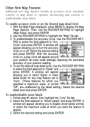
... appear allowing you to disable street labels entirely or select the maximum scale at lower scale settings) depicting the estimated accuracy of map detail to optimize decluttering and controls to “Acc. A window will appear allowing you to select higher or lower detail levels... step #1 above, then highlight the “Line” file tab. 2. Select the desired setting and press ENTER. Other New Map Features Additional new map features include an accuracy circle, automatic controls of your position reading. 4. Circle” and press ENTER. A window will appear allowing...
... appear allowing you to disable street labels entirely or select the maximum scale at lower scale settings) depicting the estimated accuracy of map detail to optimize decluttering and controls to “Acc. A window will appear allowing you to select higher or lower detail levels... step #1 above, then highlight the “Line” file tab. 2. Select the desired setting and press ENTER. Other New Map Features Additional new map features include an accuracy circle, automatic controls of your position reading. 4. Circle” and press ENTER. A window will appear allowing...
Owner's Manual
Page 4
.... MAP DATA INFORMATION: One of the goals of GARMIN is to provide customers with the most complete and accurate cartography that it in an accident or collision with property damage and personal injury. The system is subject to changes which is solely responsible for its accuracy and maintenance. Although the GPS III+ is a precision electronic NAVigation...
.... MAP DATA INFORMATION: One of the goals of GARMIN is to provide customers with the most complete and accurate cartography that it in an accident or collision with property damage and personal injury. The system is subject to changes which is solely responsible for its accuracy and maintenance. Although the GPS III+ is a precision electronic NAVigation...
Owner's Manual
Page 8
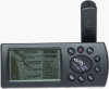
... Marking Waypoint Positions 14 About This Manual i Going to a Waypoint 15 Cautions ii Active Route Page 16 FCC Compliance iii SIMULATOR TOUR 17 Limited Warranty iv REFERENCE GETTING STARTED Satellite Status Page 25 Unit Features 1 Satellite Status Page Options 29 ... Battery Installation 3 Position Page Options 31 What is GPS 4 Map Page 33 Initialization 5 Highway Exits 35 Main Page Sequence 7 Map Page Options 36 Satellite Status Page 8 Compass Page 43 Position Page 9 Compass Page Options 44 Map Page 10 Highway Page 45 Compass Page 11 Highway...
... Marking Waypoint Positions 14 About This Manual i Going to a Waypoint 15 Cautions ii Active Route Page 16 FCC Compliance iii SIMULATOR TOUR 17 Limited Warranty iv REFERENCE GETTING STARTED Satellite Status Page 25 Unit Features 1 Satellite Status Page Options 29 ... Battery Installation 3 Position Page Options 31 What is GPS 4 Map Page 33 Initialization 5 Highway Exits 35 Main Page Sequence 7 Map Page Options 36 Satellite Status Page 8 Compass Page 43 Position Page 9 Compass Page Options 44 Map Page 10 Highway Page 45 Compass Page 11 Highway...
Owner's Manual
Page 9
Nearest Waypoints 53 GOTO 55 GOTO Options 56 MOB 57 TracBack 58 Routes 59 Route Options 65 Active Route Page 66 Active Route Page Options 67 Main Menu 69 Setup Menu 74 APPENDIX A: Dashboard Mounting 86 APPENDIX B: Specifications 87 APPENDIX C: Wiring/Interfacing 88 APPENDIX D: Antenna/Remote Mounting . . . . 89 APPENDIX E: Messages 90 APPENDIX F: Map Datums 92 APPENDIX G: Navigation Terms 95 APPENDIX H: Time Offsets 97 APPENDIX I : Index 98 INTRODUCTION Table of Contents vii
Nearest Waypoints 53 GOTO 55 GOTO Options 56 MOB 57 TracBack 58 Routes 59 Route Options 65 Active Route Page 66 Active Route Page Options 67 Main Menu 69 Setup Menu 74 APPENDIX A: Dashboard Mounting 86 APPENDIX B: Specifications 87 APPENDIX C: Wiring/Interfacing 88 APPENDIX D: Antenna/Remote Mounting . . . . 89 APPENDIX E: Messages 90 APPENDIX F: Map Datums 92 APPENDIX G: Navigation Terms 95 APPENDIX H: Time Offsets 97 APPENDIX I : Index 98 INTRODUCTION Table of Contents vii
Owner's Manual
Page 10
... find some of the more important procedures you will use a route 60 Learn about the map page 10,33 Pan using the map arrow 20,34 Zoom in or out on your new GPS III+. INTREOFDEURCETNIOCEN P"rHooxwimTioty" WInadyepxoints This list is provided to operate the unit's function keys 2 ...Mark your present location as a waypoint 14,22 Goto a destination 15,55 Create and use on the Map page 10,33 Reconfigure the Map Page display 36 Access ...
... find some of the more important procedures you will use a route 60 Learn about the map page 10,33 Pan using the map arrow 20,34 Zoom in or out on your new GPS III+. INTREOFDEURCETNIOCEN P"rHooxwimTioty" WInadyepxoints This list is provided to operate the unit's function keys 2 ...Mark your present location as a waypoint 14,22 Goto a destination 15,55 Create and use on the Map page 10,33 Reconfigure the Map Page display 36 Access ...
Owner's Manual
Page 12
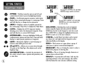
... with the keypad to change screen orientation. (MENU)- Use the rocker keypad to enter the actual data: UP/DOWN to select individual fields on the Map Page. Also adjusts scale on the ROCKER KEYPAD changes numbers and letters. The act of using the cursor to activate MOB feature. (ENTER/MARK)- Scrolls...
... with the keypad to change screen orientation. (MENU)- Use the rocker keypad to enter the actual data: UP/DOWN to select individual fields on the Map Page. Also adjusts scale on the ROCKER KEYPAD changes numbers and letters. The act of using the cursor to activate MOB feature. (ENTER/MARK)- Scrolls...
Owner's Manual
Page 15
...Navigation' or '3D Navigation' to identify your approximate position. 4. Although a GPS receiver needs four satellites to provide a three-dimensional (3D) fix, it easier to verify a position fix. You may also wish to use the IN and OUT zoom keys to make it can simply use your GPS III... initialization options. 2. The Welcome Page will inform you to position the cursor on the map display. Press ENTER to highlight 'Use Map', and press ENTER. 3. To initialize the GPS III+, designate your approximate location (within 250 miles). Use the rocker keypad and IN/OUT ...
...Navigation' or '3D Navigation' to identify your approximate position. 4. Although a GPS receiver needs four satellites to provide a three-dimensional (3D) fix, it easier to verify a position fix. You may also wish to use the IN and OUT zoom keys to make it can simply use your GPS III... initialization options. 2. The Welcome Page will inform you to position the cursor on the map display. Press ENTER to highlight 'Use Map', and press ENTER. 3. To initialize the GPS III+, designate your approximate location (within 250 miles). Use the rocker keypad and IN/OUT ...
Owner's Manual
Page 16
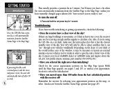
... clearest possible view of the sky. (Contact your approximate position on the map, or select 'AutoLocate' from the Satellite Page to the Map Page, unless you have manually changed pages (shown left). Also, if you're using the GPS III+ on a car dash, make sure the unit is now ready to .... Press and hold the red power key for the correct approximate position on the Map Page (press PAGE until the Map Page appears; Reinitialize the receiver by selecting your local GARMIN dealer or GARMIN Sales and inquire about the GA 26C low-profile remote antenna, part number 010-10052-04.) •...
... clearest possible view of the sky. (Contact your approximate position on the map, or select 'AutoLocate' from the Satellite Page to the Map Page, unless you have manually changed pages (shown left). Also, if you're using the GPS III+ on a car dash, make sure the unit is now ready to .... Press and hold the red power key for the correct approximate position on the Map Page (press PAGE until the Map Page appears; Reinitialize the receiver by selecting your local GARMIN dealer or GARMIN Sales and inquire about the GA 26C low-profile remote antenna, part number 010-10052-04.) •...
Owner's Manual
Page 17
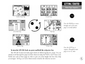
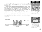
The GPS III+ features six main pages which are linked together in reverse order. quickly scroll through each of these pages in order to give you some insight into how they help you navigate. Satellite Status Page Active Route Page Position Page Map Page GETTING STARTED Main Page Sequence Press ...the PAGE key to move through the pages in either direction using the PAGE or QUIT keys. Highway Page Compass Page Press the QUIT key to To turn the GPS III+ back...
The GPS III+ features six main pages which are linked together in reverse order. quickly scroll through each of these pages in order to give you some insight into how they help you navigate. Satellite Status Page Active Route Page Position Page Map Page GETTING STARTED Main Page Sequence Press ...the PAGE key to move through the pages in either direction using the PAGE or QUIT keys. Highway Page Compass Page Press the QUIT key to To turn the GPS III+ back...
Owner's Manual
Page 19
... data fields below display your current speed, average speed, trip odometer, trip timer, and sunrise/sunset times at your current position, along with USGS topographic maps, etc. GETTING STARTED Position Page Position Page showing UTM coordinates for use when you don't have a destination selected. Below the user-selectable data fields are...
... data fields below display your current speed, average speed, trip odometer, trip timer, and sunrise/sunset times at your current position, along with USGS topographic maps, etc. GETTING STARTED Position Page Position Page showing UTM coordinates for use when you don't have a destination selected. Below the user-selectable data fields are...
Owner's Manual
Page 20
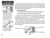
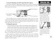
...always pointing north, oriented along your desired course, or it can also select a fullscreen map from the Map Page Options. You can automatically rotate to select a smaller scale and more about the GPS III+'s waypoint features and the Map Page in the center of the screen. See page 37. 10 The... Map Page shows your movement using a real-time track log (an electronic breadcrumb trail that appears directly on the map. To change the map scale: 1. Note the north...
...always pointing north, oriented along your desired course, or it can also select a fullscreen map from the Map Page Options. You can automatically rotate to select a smaller scale and more about the GPS III+'s waypoint features and the Map Page in the center of the screen. See page 37. 10 The... Map Page shows your movement using a real-time track log (an electronic breadcrumb trail that appears directly on the map. To change the map scale: 1. Note the north...
Owner's Manual
Page 24
...Waypoint Positions Each waypoint stored in memory is identified by a unique name, up to six characters long (letters and/or numbers). Your GPS III+ can use the GPS III+ to guide us somewhere, we can hold the ENTER/MARK key. prompt, and press ENTER. To mark your position. The Mark ...Waypoint Page will be assigned a custom waypoint symbol for the new waypoint in the GPS III+'s memory. Each waypoint may also be assigned a custom waypoint symbol, making it easy to identify the waypoint on the Map Page. Move the cursor to the left portion of the waypoint name field) and...
...Waypoint Positions Each waypoint stored in memory is identified by a unique name, up to six characters long (letters and/or numbers). Your GPS III+ can use the GPS III+ to guide us somewhere, we can hold the ENTER/MARK key. prompt, and press ENTER. To mark your position. The Mark ...Waypoint Page will be assigned a custom waypoint symbol for the new waypoint in the GPS III+'s memory. Each waypoint may also be assigned a custom waypoint symbol, making it easy to identify the waypoint on the Map Page. Move the cursor to the left portion of the waypoint name field) and...
Owner's Manual
Page 25
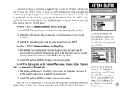
..., and then ENTER to navigate to the selected location. This captures your current position as from your present position to place the cursor over the desired destination waypoint. (If no waypoint exists at the destination location, the GPS III+ will automatically create one, named 'MAP' in the step below.)... you can be performed several ways: by specifying the destination from the GOTO Page, graphically from the map display or by using the GOTO feature. A GOTO can use the GPS III+ to guide you to it by highlighting the waypoint name on the Nearest Waypoints, Nearest Cities, Nearest ...
..., and then ENTER to navigate to the selected location. This captures your current position as from your present position to place the cursor over the desired destination waypoint. (If no waypoint exists at the destination location, the GPS III+ will automatically create one, named 'MAP' in the step below.)... you can be performed several ways: by specifying the destination from the GOTO Page, graphically from the map display or by using the GOTO feature. A GOTO can use the GPS III+ to guide you to it by highlighting the waypoint name on the Nearest Waypoints, Nearest Cities, Nearest ...
Owner's Manual
Page 27
...section of this page, press ENTER. For simulator mode operations, there's no need to wait for the GPS III+ to acquire satellites. The GPS III+ is a powerful navigation system providing detailed mapping information in the Getting Started section of this manual, and that you have not changed any settings (... for the receiver to acquire satellites. 17 After a brief self-test, it will be consulted for actual navigation. The Satellite Status Page appears next. To turn the GPS III+ on a real trip to normal operation before shutting the receiver off , we don't need to normal ...
...section of this page, press ENTER. For simulator mode operations, there's no need to wait for the GPS III+ to acquire satellites. The GPS III+ is a powerful navigation system providing detailed mapping information in the Getting Started section of this manual, and that you have not changed any settings (... for the receiver to acquire satellites. 17 After a brief self-test, it will be consulted for actual navigation. The Satellite Status Page appears next. To turn the GPS III+ on a real trip to normal operation before shutting the receiver off , we don't need to normal ...
Owner's Manual
Page 28
.... Remember, in simulator we won't see that information on to the Map Page to see where we 're in this mode the GPS III+ is ready to use this starting location from Satellite Status Page to Map Page once enough satellites were received to determine your position. Let's look... satellites. 18 To select the simulator mode: 1. In normal mode operation, the GPS III+ would automatically sequence from which to begin our simulated trip. The PAGE and QUIT keys are , create a destination and explore the navigation features of steps, but as you 've already initialized the receiver, as a ...
.... Remember, in simulator we won't see that information on to the Map Page to see where we 're in this mode the GPS III+ is ready to use this starting location from Satellite Status Page to Map Page once enough satellites were received to determine your position. Let's look... satellites. 18 To select the simulator mode: 1. In normal mode operation, the GPS III+ would automatically sequence from which to begin our simulated trip. The PAGE and QUIT keys are , create a destination and explore the navigation features of steps, but as you 've already initialized the receiver, as a ...
Owner's Manual
Page 29
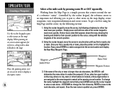
... your current direction of travel at the top of the screen ('Track Up'). The Map Page also shows any one of over 70 different symbols, with a number of user-selectable features. The GPS III+'s Map Page combines digital charting with the waypoint name displayed directly above the symbol. Let's ... select a smaller scale and display a smaller geographic area. 2. Nearby waypoints are depicted on the map display to see how that process works, then we select our destination and begin navigating toward it appears. Use the IN/OUT zoom keys to this new waypoint. In the 'Track ...
... your current direction of travel at the top of the screen ('Track Up'). The Map Page also shows any one of over 70 different symbols, with a number of user-selectable features. The GPS III+'s Map Page combines digital charting with the waypoint name displayed directly above the symbol. Let's ... select a smaller scale and display a smaller geographic area. 2. Nearby waypoints are depicted on the map display to see how that process works, then we select our destination and begin navigating toward it appears. Use the IN/OUT zoom keys to this new waypoint. In the 'Track ...
Owner's Manual
Page 30
... to change the name, highlight the waypoint name field, press ENTER and use of the city or town is longer than six characters, the GPS III+ will abbreviate the name when it to other feature) near your position. Using the rocker keypad to the next character, and repeat. Notice ...how a data field appears above the map. Waypoint Symbol Field Waypoint Name Field Waypoint Position 3. If the name of a reference "arrow". To get a feel for reference, along with a ...
... to change the name, highlight the waypoint name field, press ENTER and use of the city or town is longer than six characters, the GPS III+ will abbreviate the name when it to other feature) near your position. Using the rocker keypad to the next character, and repeat. Notice ...how a data field appears above the map. Waypoint Symbol Field Waypoint Name Field Waypoint Position 3. If the name of a reference "arrow". To get a feel for reference, along with a ...
Owner's Manual
Page 31
... all waypoints currently in memory.) 21 If the 'All' file tab is used to GOTO any point on the GOTO Page, to see how the GPS III+ is not selected, use the rocker keypad to identify it as a waypoint, or • You can mark your present position now and save it ...your present position when you're done for creating and naming a waypoint wouldn't be used to navigate to it as a waypoint. (You might want to return to experiment with the TracBack feature later. A waypoint named 'MAP' is assigned to our destination. You might want to experiment with this tab. ('All' will...
... all waypoints currently in memory.) 21 If the 'All' file tab is used to GOTO any point on the GOTO Page, to see how the GPS III+ is not selected, use the rocker keypad to identify it as a waypoint, or • You can mark your present position now and save it ...your present position when you're done for creating and naming a waypoint wouldn't be used to navigate to it as a waypoint. (You might want to return to experiment with the TracBack feature later. A waypoint named 'MAP' is assigned to our destination. You might want to experiment with this tab. ('All' will...


