

Owner's Manual
Page 3
...navigation system, take time to create an unsurpassed portable GPS receiver. The Introduction section contains the Table of Garmin GPS and full-featured mapping to read this package with the packing list on using waypoints. See the CANet accessory installation instructions for choosing the Garmin® GPSMAP® 392/398/492/498... are missing, contact your chartplotter, contact Garmin Product Support or a professional installer. The GPSMAP 392/398/492/498 utilizes the proven performance of Contents as well as using the Find Menu, navigating a route, and using the pages. ...
...navigation system, take time to create an unsurpassed portable GPS receiver. The Introduction section contains the Table of Garmin GPS and full-featured mapping to read this package with the packing list on using waypoints. See the CANet accessory installation instructions for choosing the Garmin® GPSMAP® 392/398/492/498... are missing, contact your chartplotter, contact Garmin Product Support or a professional installer. The GPSMAP 392/398/492/498 utilizes the proven performance of Contents as well as using the Find Menu, navigating a route, and using the pages. ...
Owner's Manual
Page 4
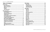
... Manual i Manual Conventions i Warning iv Caution v Care Information vi Basic Operation 1 Initializing the Receiver 1 Simulator Mode 3 Adjusting the Backlight 4 Interface Keys 5 Entering Data and Selecting Options 6 Using... 7 Creating and Using Waypoints 8 Man OverBoard (MOB 10 Reviewing and Editing Waypoints 11 Navigating to a Destination 12 Creating and Using Routes 17 Find 19 Additional Information 21 DSC ... 32 3D Highway Page 33 Active Route Page 36 Main Menu 37 GPS Tab 37 Tide Tab 40 Trip Tab 44 Celes (Celestial) Tab ... 70 ii GPSMAP 392/398/492/498 Owner's Manual
... Manual i Manual Conventions i Warning iv Caution v Care Information vi Basic Operation 1 Initializing the Receiver 1 Simulator Mode 3 Adjusting the Backlight 4 Interface Keys 5 Entering Data and Selecting Options 6 Using... 7 Creating and Using Waypoints 8 Man OverBoard (MOB 10 Reviewing and Editing Waypoints 11 Navigating to a Destination 12 Creating and Using Routes 17 Find 19 Additional Information 21 DSC ... 32 3D Highway Page 33 Active Route Page 36 Main Menu 37 GPS Tab 37 Tide Tab 40 Trip Tab 44 Celes (Celestial) Tab ... 70 ii GPSMAP 392/398/492/498 Owner's Manual

Owner's Manual
Page 9
... in the "Appendix." Install the antenna in AutoLocate Mode. The GPS Information Page appears as the receiver begins acquiring satellites. Before you press ENTER to collect satellite data and establish its present location. GPSMAP 392/398/492/498 Owner's Manual BASIC OPERATION > INITIALIZING THE RECEIVER 3. When the self-test is blank, release the POWER key...
... in the "Appendix." Install the antenna in AutoLocate Mode. The GPS Information Page appears as the receiver begins acquiring satellites. Before you press ENTER to collect satellite data and establish its present location. GPSMAP 392/398/492/498 Owner's Manual BASIC OPERATION > INITIALIZING THE RECEIVER 3. When the self-test is blank, release the POWER key...
Owner's Manual
Page 10
... your approximate location on the ROCKER until the GPS tab is ready to use . 2 GPSMAP 392/398/492/498 Owner's Manual When viewing the GPS tab on the bottom of the screen shows either "Ready for Navigation" during this process, it helps to initialize the unit. When the receiver has collected information from at least three...
... your approximate location on the ROCKER until the GPS tab is ready to use . 2 GPSMAP 392/398/492/498 Owner's Manual When viewing the GPS tab on the bottom of the screen shows either "Ready for Navigation" during this process, it helps to initialize the unit. When the receiver has collected information from at least three...

Owner's Manual
Page 11
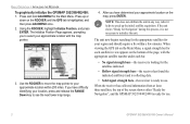
...Simulator, and press ENTER. 3. If the status bar is retained in Simulator Mode, and this mode should never be used for actual navigation. You can perform any of the screen. Any satellite signal strength bars shown are only simulations and do not represent the strength of ... in Simulator Mode: 1. Use the ROCKER to Simulator Mode, the GPS receiver is set to highlight the GPS tab, and then press ADJ/MENU once. 2. GPSMAP 392/398/492/498 Owner's Manual 3 Simulator Mode Simulator Mode turns the GPS receiver off for future use indoors or practice. When the unit is turned...
...Simulator, and press ENTER. 3. If the status bar is retained in Simulator Mode, and this mode should never be used for actual navigation. You can perform any of the screen. Any satellite signal strength bars shown are only simulations and do not represent the strength of ... in Simulator Mode: 1. Use the ROCKER to Simulator Mode, the GPS receiver is set to highlight the GPS tab, and then press ADJ/MENU once. 2. GPSMAP 392/398/492/498 Owner's Manual 3 Simulator Mode Simulator Mode turns the GPS receiver off for future use indoors or practice. When the unit is turned...
Owner's Manual
Page 29
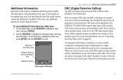
... the field, and press ENTER. DSC uses marine VHF radio and GPS technologies to highlight a map item, and press ENTER. 2. An emergency DSC distress call or position report. The rescuer can choose to navigate to the caller's location to the Coast Guard. The information varies depending on..., and sound/show the information. The GPSMAP 392/398/492/498 requires input from a DSC-enabled VHF radio to highlight the individual tabs, and show alerts from a GPS to transmit a substantial amount of data loaded on page 92. When any nearby rescuer receives the DSC signal, an alarm sounds and...
... the field, and press ENTER. DSC uses marine VHF radio and GPS technologies to highlight a map item, and press ENTER. 2. An emergency DSC distress call or position report. The rescuer can choose to navigate to the caller's location to the Coast Guard. The information varies depending on..., and sound/show the information. The GPSMAP 392/398/492/498 requires input from a DSC-enabled VHF radio to highlight the individual tabs, and show alerts from a GPS to transmit a substantial amount of data loaded on page 92. When any nearby rescuer receives the DSC signal, an alarm sounds and...
Owner's Manual
Page 45
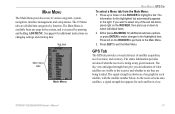
... Press up or down on changing settings and entering data. GPSMAP 392/398/492/498 Owner's Manual 37 Sub tabs Main menu tabs Main Menu MAIN MENU > GPS TAB To select a Menu tab from any given moment. GPS Tab The GPS tab provides a visual reference of the sub tab items, press...press ADJ/MENU for additional submenu options, or press ENTER to make changes to various waypoint, system, navigation, interface management, and setup menus. Press QUIT to select any of satellite acquisition, receiver status, and accuracy. The sky view and signal strength bars give you want to exit the Main ...
... Press up or down on changing settings and entering data. GPSMAP 392/398/492/498 Owner's Manual 37 Sub tabs Main menu tabs Main Menu MAIN MENU > GPS TAB To select a Menu tab from any given moment. GPS Tab The GPS tab provides a visual reference of the sub tab items, press...press ADJ/MENU for additional submenu options, or press ENTER to make changes to various waypoint, system, navigation, interface management, and setup menus. Press QUIT to select any of satellite acquisition, receiver status, and accuracy. The sky view and signal strength bars give you want to exit the Main ...
Owner's Manual
Page 46
... configuration, causing the top of each satellite relative to the receiver's last known location. MAIN MENU > GPS TAB Accuracy Receiver status WAAS status Signal strength bars The status field indicates "Ready for Navigation" when the GPSMAP 392/398/492/498 has collected the necessary data from satellites visible at its last known or...
... configuration, causing the top of each satellite relative to the receiver's last known location. MAIN MENU > GPS TAB Accuracy Receiver status WAAS status Signal strength bars The status field indicates "Ready for Navigation" when the GPSMAP 392/398/492/498 has collected the necessary data from satellites visible at its last known or...
Owner's Manual
Page 67
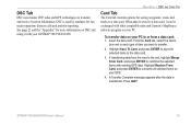
... options for more information on DSC and using it can be exchanged with other compatible units and Garmin's MapSource software program on your GPS. 4. Insert the data card. Press QUIT. GPSMAP 392/398/492/498 Owner's Manual 59 From the Card tab, select the check box next to each type of ...item you want to transmit and receive location information. DSC is transferred. DSC Tab DSC uses marine VHF radio and GPS technologies to...
... options for more information on DSC and using it can be exchanged with other compatible units and Garmin's MapSource software program on your GPS. 4. Insert the data card. Press QUIT. GPSMAP 392/398/492/498 Owner's Manual 59 From the Card tab, select the check box next to each type of ...item you want to transmit and receive location information. DSC is transferred. DSC Tab DSC uses marine VHF radio and GPS technologies to...
Owner's Manual
Page 94
... Display: 5.0" diagonal (12.7 cm) 256-color TFT display with backlighting (234 x 320 pixels) Case: Fully gasketed, high-impact plastic alloy, waterproof to 70°C) Performance Receiver: Differential-ready 12 parallel channel WAAS-capable receiver Acquisition Times: Warm: Approx. 15 seconds Cold: Approx. 45 seconds AutoLocate: Approx. 2 minutes Update Rate: 1/second, continuous...
... Display: 5.0" diagonal (12.7 cm) 256-color TFT display with backlighting (234 x 320 pixels) Case: Fully gasketed, high-impact plastic alloy, waterproof to 70°C) Performance Receiver: Differential-ready 12 parallel channel WAAS-capable receiver Acquisition Times: Warm: Approx. 15 seconds Cold: Approx. 45 seconds AutoLocate: Approx. 2 minutes Update Rate: 1/second, continuous...
Owner's Manual
Page 103
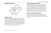
... filled. When the unit is using a satellite for navigation, the satellite number is using the satellite signal for navigation. The gray bar means the GPS is in the process of storing orbital data it is being received, and the status of the signal. The unit can be... set to that differential corrections (WAAS) is receiving from the satellite's on-board atomic clock. When the bar turns solid, the GPS is highlighted on the Satellite Information Page. GPSMAP 392/398/492/498 Owner's Manual 95 A "D" in the selected location format. APPENDIX > ...
... filled. When the unit is using a satellite for navigation, the satellite number is using the satellite signal for navigation. The gray bar means the GPS is in the process of storing orbital data it is being received, and the status of the signal. The unit can be... set to that differential corrections (WAAS) is receiving from the satellite's on-board atomic clock. When the bar turns solid, the GPS is highlighted on the Satellite Information Page. GPSMAP 392/398/492/498 Owner's Manual 95 A "D" in the selected location format. APPENDIX > ...
Owner's Manual
Page 104
... ground reference stations positioned across the United States that adheres to as transmitted by GPS satellites alone. According to http://gps.faa.gov. 96 GPSMAP 392/398/492/498 Owner's Manual For this reason, when you enable WAAS on your Garmin GPS receiver, the receiver automatically uses the method that are not supported by ground stations, may not...
... ground reference stations positioned across the United States that adheres to as transmitted by GPS satellites alone. According to http://gps.faa.gov. 96 GPSMAP 392/398/492/498 Owner's Manual For this reason, when you enable WAAS on your Garmin GPS receiver, the receiver automatically uses the method that are not supported by ground stations, may not...
Owner's Manual
Page 108
...Error-internal problem with the unit. Distress Call-a DSC distress call has been received. Anchor Drag Alarm-you to problems. Press QUIT to acknowledge a message or alarm. Contact your dealer or Garmin Product Support to add new ones. Approaching [Waypoint Name]-you arrived at the...distance from a destination waypoint. Delete unneeded contacts to have drifted out of the Drift Alarm value. 100 GPSMAP 392/398/492/498 Owner's Manual Accuracy Alarm-the GPS accuracy has fallen outside of events and alert you have the unit serviced. Directory Memory is contacting the chassis...
...Error-internal problem with the unit. Distress Call-a DSC distress call has been received. Anchor Drag Alarm-you to problems. Press QUIT to acknowledge a message or alarm. Contact your dealer or Garmin Product Support to add new ones. Approaching [Waypoint Name]-you arrived at the...distance from a destination waypoint. Delete unneeded contacts to have drifted out of the Drift Alarm value. 100 GPSMAP 392/398/492/498 Owner's Manual Accuracy Alarm-the GPS accuracy has fallen outside of events and alert you have the unit serviced. Directory Memory is contacting the chassis...
Owner's Manual
Page 111
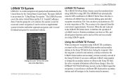
...secondary stations and still navigate to Loran TD from the Units tab on the LORAN signal for navigation, it simulates the operation of a LORAN receiver. The accuracy to using GPS. If you must set... field. Since the GPSMAP 392/398/492/498 does not rely on the Main Menu. Position coordinates can show as TDs, and all navigation functions can show your position as...recreational vehicles. LORAN TD System LORAN-C is a radio navigation aid operated and maintained in memory. 103 The GPSMAP unit automatically converts GPS coordinates to LORAN TDs for favorite fishing spots ...
...secondary stations and still navigate to Loran TD from the Units tab on the LORAN signal for navigation, it simulates the operation of a LORAN receiver. The accuracy to using GPS. If you must set... field. Since the GPSMAP 392/398/492/498 does not rely on the Main Menu. Position coordinates can show as TDs, and all navigation functions can show your position as...recreational vehicles. LORAN TD System LORAN-C is a radio navigation aid operated and maintained in memory. 103 The GPSMAP unit automatically converts GPS coordinates to LORAN TDs for favorite fishing spots ...


