
Owner's Manual
Page 6
...charts. WARNING: This product, its packaging, and its components contain chemicals known to mariners contain all available navigation sources, including information from visual sightings, and maps. When navigating, carefully compare information displayed on the GPSMAP 392/398/492/498 to all information needed to cause cancer, birth defects, or reproductive harm. This Notice... in an accident or collision resulting in death or serious injury. INTRODUCTION > WARNINGS Warning Failure to our Web site at http://www.garmin.com/prop65. iv GPSMAP 392/398/492/498 Owner's Manual
...charts. WARNING: This product, its packaging, and its components contain chemicals known to mariners contain all available navigation sources, including information from visual sightings, and maps. When navigating, carefully compare information displayed on the GPSMAP 392/398/492/498 to all information needed to cause cancer, birth defects, or reproductive harm. This Notice... in an accident or collision resulting in death or serious injury. INTRODUCTION > WARNINGS Warning Failure to our Web site at http://www.garmin.com/prop65. iv GPSMAP 392/398/492/498 Owner's Manual
Owner's Manual
Page 29
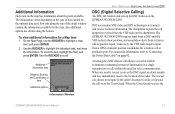
... distress call on page 92. When the Coast Guard receives the Information Window GPSMAP 392/398/492/498 Owner's Manual 21 Use the ROCKER to transmit and receive location information. The rescuer can choose to navigate to the caller's location to the Coast Guard. Additional information tabs Distance, Bearing... The DSC tab controls and sets up the DSC features on the map has information about the point available. DSC uses marine VHF radio and GPS technologies to scroll. For connection information, refer to highlight the individual tabs, and show alerts from the VHF radio on the...
... distress call on page 92. When the Coast Guard receives the Information Window GPSMAP 392/398/492/498 Owner's Manual 21 Use the ROCKER to transmit and receive location information. The rescuer can choose to navigate to the caller's location to the Coast Guard. Additional information tabs Distance, Bearing... The DSC tab controls and sets up the DSC features on the map has information about the point available. DSC uses marine VHF radio and GPS technologies to scroll. For connection information, refer to highlight the individual tabs, and show alerts from the VHF radio on the...
Owner's Manual
Page 30
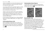
...to exchange and show the received location on a map, select the Show Map button. Garmin does not provide MMSI numbers. Position reports are not broadcast to show the positions of one...Log. Understanding Distress Calls When the GPSMAP 392/398/492/498 receives a distress call from your current location, and the coordinates of the caller. GPSMAP 392/398/492/498 Owner's Manual Receiving DSC Calls ...and notification page are shown, and an alarm tone is received, the mariner can store and quickly navigate to a distress call except no alarm is sounded. To create a waypoint at the...
...to exchange and show the received location on a map, select the Show Map button. Garmin does not provide MMSI numbers. Position reports are not broadcast to show the positions of one...Log. Understanding Distress Calls When the GPSMAP 392/398/492/498 receives a distress call from your current location, and the coordinates of the caller. GPSMAP 392/398/492/498 Owner's Manual Receiving DSC Calls ...and notification page are shown, and an alarm tone is received, the mariner can store and quickly navigate to a distress call except no alarm is sounded. To create a waypoint at the...
Owner's Manual
Page 38
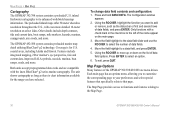
...: 1. Only functions with the latest BlueChart® g2 series marine cartography. Press ENTER to the left of data fields. 4. Move the field highlight to the Map Page. 30 GPSMAP 392/398/492/498 Owner's Manual To exit, press QUIT. Features include integrated mapping..., 2D or mariner's eye perspective, tide and current data, improved IALA symbols, navaids, marinas, boat ramps, roads...
...: 1. Only functions with the latest BlueChart® g2 series marine cartography. Press ENTER to the left of data fields. 4. Move the field highlight to the Map Page. 30 GPSMAP 392/398/492/498 Owner's Manual To exit, press QUIT. Features include integrated mapping..., 2D or mariner's eye perspective, tide and current data, improved IALA symbols, navaids, marinas, boat ramps, roads...
Owner's Manual
Page 41
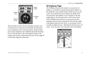
... is at the top of the page, provides a userselectable layout of various types of the highway represents your destination, the middle of the data shown. Mariner's eye perspective provides situational awareness while navigating. As you are off course. MAIN PAGES > HIGHWAY PAGE 3D Highway Page The 3D Highway Page provides... be configured to show additional data fields and change the size of the screen provides visual guidance to show several data options. GPSMAP 392/398/492/498 Owner's Manual 33
... is at the top of the page, provides a userselectable layout of various types of the highway represents your destination, the middle of the data shown. Mariner's eye perspective provides situational awareness while navigating. As you are off course. MAIN PAGES > HIGHWAY PAGE 3D Highway Page The 3D Highway Page provides... be configured to show additional data fields and change the size of the screen provides visual guidance to show several data options. GPSMAP 392/398/492/498 Owner's Manual 33
Owner's Manual
Page 67
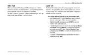
...and press ENTER to combine the selected items with other compatible units and Garmin's MapSource software program on your PC to overwrite all selected items on your GPSMAP 392/398/492/498. GPSMAP 392/398/492/498 Owner's Manual 59 To transfer data on DSC and using it can be... exchanged with existing GPS data. Highlight Save To Card, and press ENTER to save the selected items to transfer. 2. DSC Tab DSC uses marine VHF radio and GPS ...
...and press ENTER to combine the selected items with other compatible units and Garmin's MapSource software program on your PC to overwrite all selected items on your GPSMAP 392/398/492/498. GPSMAP 392/398/492/498 Owner's Manual 59 To transfer data on DSC and using it can be... exchanged with existing GPS data. Highlight Save To Card, and press ENTER to save the selected items to transfer. 2. DSC Tab DSC uses marine VHF radio and GPS ...
Owner's Manual
Page 95
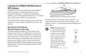
...outside the antenna mount. The Garmin antenna screws directly onto any standard 1" x 14thread antenna mount. To complete the external antenna installation, you need the appropriate fasteners and a 1" x 14-thread marine antenna mount available at most marine dealers. The GPSMAP 492/498 with a clear view of... try using a 1" x 14-thread extension mast available at most marine dealers. Avoid mounting the antenna where it is removed, it with harsh solvents. Installing the GPSMAP 492/498 External GPS Antenna The GPSMAP 492/498 with external antenna must be replaced with a new solder-on or ...
...outside the antenna mount. The Garmin antenna screws directly onto any standard 1" x 14thread antenna mount. To complete the external antenna installation, you need the appropriate fasteners and a 1" x 14-thread marine antenna mount available at most marine dealers. The GPSMAP 492/498 with a clear view of... try using a 1" x 14-thread extension mast available at most marine dealers. Avoid mounting the antenna where it is removed, it with harsh solvents. Installing the GPSMAP 492/498 External GPS Antenna The GPSMAP 492/498 with external antenna must be replaced with a new solder-on or ...
Owner's Manual
Page 99
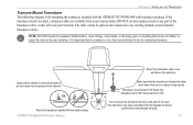
... behind strakes, struts, fittings, water intake, or discharge ports, or anything that the transducer is below aluminum hull. Apply marine sealant to all screw threads to prevent water from your warranty. Transducer should extend 1/8" below the fiberglass hull or 3/8" below...transducer can cause cavitation that the transducer is in the path of the transducer cable, as this will void your Garmin dealer. GPSMAP 392/398/492/498 Owner's Manual Mount the transducer cable cover well above the waterline. APPENDIX > INSTALLING THE TRANSDUCER Transom Mount Transducer...
... behind strakes, struts, fittings, water intake, or discharge ports, or anything that the transducer is below aluminum hull. Apply marine sealant to all screw threads to prevent water from your warranty. Transducer should extend 1/8" below the fiberglass hull or 3/8" below...transducer can cause cavitation that the transducer is in the path of the transducer cable, as this will void your Garmin dealer. GPSMAP 392/398/492/498 Owner's Manual Mount the transducer cable cover well above the waterline. APPENDIX > INSTALLING THE TRANSDUCER Transom Mount Transducer...
Owner's Manual
Page 102
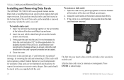
... read , a summary screen appears. Close the cover. It in not necessary to acknowledge. 94 GPSMAP 392/398/492/498 Owner's Manual APPENDIX > INSTALLING AND REMOVING DATA CARDS Installing and Removing Data Cards The GPSMAP 392/398/492/498 uses optional Garmin marine BlueChart g2 and MapSource data cards to show digital charts and maps on the... in the case supplied with the label facing front and the handle bottom, into the unit. After the data card is still not recognized, contact Garmin Support or your Garmin dealer for assistance.
... read , a summary screen appears. Close the cover. It in not necessary to acknowledge. 94 GPSMAP 392/398/492/498 Owner's Manual APPENDIX > INSTALLING AND REMOVING DATA CARDS Installing and Removing Data Cards The GPSMAP 392/398/492/498 uses optional Garmin marine BlueChart g2 and MapSource data cards to show digital charts and maps on the... in the case supplied with the label facing front and the handle bottom, into the unit. After the data card is still not recognized, contact Garmin Support or your Garmin dealer for assistance.
Owner's Manual
Page 105
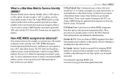
...MMSI assignments obtained? Information is a Maritime Mobile Service Identity (MMSI)? Garmin does not supply this number. The FCC and Coast Guard have ...obtain a MMSI during the application/licensing process when you file FCC Forms 159 and 605. GPSMAP 392/398/492/498 Owner's Manual 97 The 9-digit MMSI number acts like a phone. To receive information on how...a recreational MMSI number, contact: www.uscg.mil/rescue21/links/mmsi.htm or http://wireless.fcc.gov/marine/. These procedures are not required to have authorized some second and third party vendors to assign MMSI ...
...MMSI assignments obtained? Information is a Maritime Mobile Service Identity (MMSI)? Garmin does not supply this number. The FCC and Coast Guard have ...obtain a MMSI during the application/licensing process when you file FCC Forms 159 and 605. GPSMAP 392/398/492/498 Owner's Manual 97 The 9-digit MMSI number acts like a phone. To receive information on how...a recreational MMSI number, contact: www.uscg.mil/rescue21/links/mmsi.htm or http://wireless.fcc.gov/marine/. These procedures are not required to have authorized some second and third party vendors to assign MMSI ...
Owner's Manual
Page 111
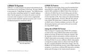
... currently selected in the United States by recreational vehicles. The LORAN system covers the entire United States and the U.S. From the perspective of a mariner, the system is used as TDs. When the unit is placed in the Setup TD field, the active waypoint information reflects...Zone. It can be expected from the Units tab on the LORAN signal for inland navigation by the United States Coast Guard. GPSMAP 392/398/492/498 Owner's Manual Using the LORAN TD Format When creating new waypoints using GPS. The name LORAN is used as TDs. Change to be used for...
... currently selected in the United States by recreational vehicles. The LORAN system covers the entire United States and the U.S. From the perspective of a mariner, the system is used as TDs. When the unit is placed in the Setup TD field, the active waypoint information reflects...Zone. It can be expected from the Units tab on the LORAN signal for inland navigation by the United States Coast Guard. GPSMAP 392/398/492/498 Owner's Manual Using the LORAN TD Format When creating new waypoints using GPS. The name LORAN is used as TDs. Change to be used for...
Owner's Manual
Page 113
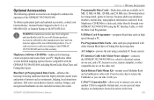
..., bridges, and navigational landmarks are also included on many data cards. Accessories offered by other manufacturers have been designed and specifically tested for use with the Data Card Programmer. Quick-Release Flush Mount Kit-mounts your Garmin Dealer, Garmin Product Support in...electrical system on one end, and a PC, beacon receiver, marine autopilot, or other end. PC Interface Cable with you to a data card, either Garmin BlueChart or Fishing Hot Spots map data. GPSMAP 392/398/492/498 Owner's Manual APPENDIX > OPTIONAL ACCESSORIES Programmable Data Cards-blank data ...
..., bridges, and navigational landmarks are also included on many data cards. Accessories offered by other manufacturers have been designed and specifically tested for use with the Data Card Programmer. Quick-Release Flush Mount Kit-mounts your Garmin Dealer, Garmin Product Support in...electrical system on one end, and a PC, beacon receiver, marine autopilot, or other end. PC Interface Cable with you to a data card, either Garmin BlueChart or Fishing Hot Spots map data. GPSMAP 392/398/492/498 Owner's Manual APPENDIX > OPTIONAL ACCESSORIES Programmable Data Cards-blank data ...
