

Owner's Manual
Page 3
...about the Main Menu and how to use it to create an unsurpassed portable GPS receiver. The GPSMAP 392/398/492/498 Sounder is organized into the following sections. About This Manual To get the most out of Garmin GPS and full-featured mapping to configure your unit in detail. This ... end of Contents as well as using the Find Menu, navigating a route, and using the pages. If any question about each page in the GPSMAP 392/398/492/498 and step-by -step directions for features such as GPSMAP 392/398/492/498 care information. You can also find warranty and FCC...
...about the Main Menu and how to use it to create an unsurpassed portable GPS receiver. The GPSMAP 392/398/492/498 Sounder is organized into the following sections. About This Manual To get the most out of Garmin GPS and full-featured mapping to configure your unit in detail. This ... end of Contents as well as using the Find Menu, navigating a route, and using the pages. If any question about each page in the GPSMAP 392/398/492/498 and step-by -step directions for features such as GPSMAP 392/398/492/498 care information. You can also find warranty and FCC...
Owner's Manual
Page 4
... Selecting Options 6 Using the Map Pointer 7 Creating and Using Waypoints 8 Man OverBoard (MOB 10 Reviewing and Editing Waypoints 11 Navigating to a Destination 12 Creating and Using Routes 17 Find 19 Additional Information 21 DSC (Digital Selective Calling 21 AIS 25 Main ...Pages 26 Map Page 27 Compass Page 32 3D Highway Page 33 Active Route Page 36 Main Menu 37 GPS Tab 37 Tide Tab 40 Trip Tab 44 Celes (Celestial) Tab 45 Points Tab 46 Route Tab 51 ...Temp (Temperature) Tab 64 Sonar Tab 64 Systm (System) Tab 65 Alarm Tab 70 ii GPSMAP 392/398/492/498 Owner's Manual
... Selecting Options 6 Using the Map Pointer 7 Creating and Using Waypoints 8 Man OverBoard (MOB 10 Reviewing and Editing Waypoints 11 Navigating to a Destination 12 Creating and Using Routes 17 Find 19 Additional Information 21 DSC (Digital Selective Calling 21 AIS 25 Main ...Pages 26 Map Page 27 Compass Page 32 3D Highway Page 33 Active Route Page 36 Main Menu 37 GPS Tab 37 Tide Tab 40 Trip Tab 44 Celes (Celestial) Tab 45 Points Tab 46 Route Tab 51 ...Temp (Temperature) Tab 64 Sonar Tab 64 Systm (System) Tab 65 Alarm Tab 70 ii GPSMAP 392/398/492/498 Owner's Manual

Owner's Manual
Page 5
...Options 79 Flasher Page 84 Map Split Page 85 Appendix 86 Specifications 86 Installing the GPSMAP 492/498 External GPS Antenna..... 87 Mounting the GPSMAP 392/398/492/498 88 Installing the Transducer 90 Connecting the Power/Data Cable 92 Interfacing 93 Installing and Removing ... assignments obtained 97 Navigation Terms 98 Messages and Alarms 100 LORAN TD System 103 Optional Accessories 105 Software License Agreement 106 Product Registration 106 Limited Warranty 107 FCC Compliance 108 Declaration of Conformity (DoC 108 Index 109 GPSMAP 392/398/492/498 Owner's Manual iii
...Options 79 Flasher Page 84 Map Split Page 85 Appendix 86 Specifications 86 Installing the GPSMAP 492/498 External GPS Antenna..... 87 Mounting the GPSMAP 392/398/492/498 88 Installing the Transducer 90 Connecting the Power/Data Cable 92 Interfacing 93 Installing and Removing ... assignments obtained 97 Navigation Terms 98 Messages and Alarms 100 LORAN TD System 103 Optional Accessories 105 Software License Agreement 106 Product Registration 106 Limited Warranty 107 FCC Compliance 108 Declaration of Conformity (DoC 108 Index 109 GPSMAP 392/398/492/498 Owner's Manual iii
Owner's Manual
Page 7
... Electronic Waste Recycling Act of 2003 requires the recycling of Garmin is to provide customers with the most complete and accurate cartography that is prohibitively expensive. Use the GPSMAP 392/398/492/498 only as a navigational aid. Virtually all GPS equipment, including the GPSMAP 392/398/492/498. In some extent. Do not attempt to this product...
... Electronic Waste Recycling Act of 2003 requires the recycling of Garmin is to provide customers with the most complete and accurate cartography that is prohibitively expensive. Use the GPSMAP 392/398/492/498 only as a navigational aid. Virtually all GPS equipment, including the GPSMAP 392/398/492/498. In some extent. Do not attempt to this product...

Owner's Manual
Page 9
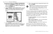
...the POWER key. 2. To turn off the GPSMAP 392/398/492/498: 1. GPSMAP 392/398/492/498 Owner's Manual BASIC OPERATION > INITIALIZING THE RECEIVER 3. To turn on the GPSMAP 392/398/492/498: 1. Before you initialize, make sure the GPSMAP 392/398/492/498 unit and antenna are only asked this the... while the unit conducts a self-test. 2. To ensure proper initialization, the GPSMAP 392/398/492/498 is shown after the unit gets a position fix, or you start the Retail Demonstration?". A full-screen GPS Information Page is shipped from the factory in a location with a clear and ...
...the POWER key. 2. To turn off the GPSMAP 392/398/492/498: 1. GPSMAP 392/398/492/498 Owner's Manual BASIC OPERATION > INITIALIZING THE RECEIVER 3. To turn on the GPSMAP 392/398/492/498: 1. Before you initialize, make sure the GPSMAP 392/398/492/498 unit and antenna are only asked this the... while the unit conducts a self-test. 2. To ensure proper initialization, the GPSMAP 392/398/492/498 is shown after the unit gets a position fix, or you start the Retail Demonstration?". A full-screen GPS Information Page is shipped from the factory in a location with a clear and ...
Owner's Manual
Page 10
...up or down on the bottom of the screen shows either "Ready for Navigation" during this process, it is highlighted, and then press ADJ/MENU once. 2. If the unit shows "Ready for Navigation", and the GPSMAP 392/398/492/498 is ready to select your region and should acquire a fix within... 200 miles. When viewing the GPS tab on the Main Menu, a signal strength bar for each bar. • No...
...up or down on the bottom of the screen shows either "Ready for Navigation" during this process, it is highlighted, and then press ADJ/MENU once. 2. If the unit shows "Ready for Navigation", and the GPSMAP 392/398/492/498 is ready to select your region and should acquire a fix within... 200 miles. When viewing the GPS tab on the Main Menu, a signal strength bar for each bar. • No...

Owner's Manual
Page 11
... mode should never be used for actual navigation. Press QUIT to Simulator Mode, the GPS receiver is turned on, "Simulating" appears at the bottom of actual satellite signals. To turn off . BASIC OPERATION > SIMULATOR MODE To place the GPSMAP 392/398/492/498 in Simulator Mode. Press and hold ADJ... at the top of each of the functions discussed in the following pages in Simulator Mode: 1. Use the ROCKER to navigate using Simulator Mode. GPSMAP 392/398/492/498 Owner's Manual 3 You can perform any of the main pages. 4. Any satellite signal strength bars shown are only simulations...
... mode should never be used for actual navigation. Press QUIT to Simulator Mode, the GPS receiver is turned on, "Simulating" appears at the bottom of actual satellite signals. To turn off . BASIC OPERATION > SIMULATOR MODE To place the GPSMAP 392/398/492/498 in Simulator Mode. Press and hold ADJ... at the top of each of the functions discussed in the following pages in Simulator Mode: 1. Use the ROCKER to navigate using Simulator Mode. GPSMAP 392/398/492/498 Owner's Manual 3 You can perform any of the main pages. 4. Any satellite signal strength bars shown are only simulations...
Owner's Manual
Page 29
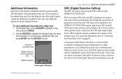
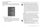
Sub tabs along the bottom. DSC uses marine VHF radio and GPS technologies to scroll. The chartplotter repeats the call or position report. When the Coast Guard receives the Information Window GPSMAP 392/398/492/498 Owner's Manual 21 Use the ROCKER to transmit and receive location information. Additional Information Each item on ...the detail window contain the information available for a Map item: 1. The information varies depending on the type of the caller. The rescuer can choose to navigate to the caller's location to highlight a map item, and press ENTER. 2.
Sub tabs along the bottom. DSC uses marine VHF radio and GPS technologies to scroll. The chartplotter repeats the call or position report. When the Coast Guard receives the Information Window GPSMAP 392/398/492/498 Owner's Manual 21 Use the ROCKER to transmit and receive location information. Additional Information Each item on ...the detail window contain the information available for a Map item: 1. The information varies depending on the type of the caller. The rescuer can choose to navigate to the caller's location to highlight a map item, and press ENTER. 2.
Owner's Manual
Page 45
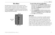
The information for the highlighted tab automatically appears to exit the Main Menu. Press QUIT to the right. GPSMAP 392/398/492/498 Owner's Manual 37 Either press ADJ/MENU for each satellite, with the satellite number below. The status information provides an idea ... The GPS tab provides a visual reference of what the receiver is accessed by function. As the receiver locks onto satellites, a signal strength bar appears for additional submenu options, or press ENTER to make changes to various waypoint, system, navigation, interface management, and setup menus. Press up or ...
The information for the highlighted tab automatically appears to exit the Main Menu. Press QUIT to the right. GPSMAP 392/398/492/498 Owner's Manual 37 Either press ADJ/MENU for each satellite, with the satellite number below. The status information provides an idea ... The GPS tab provides a visual reference of what the receiver is accessed by function. As the receiver locks onto satellites, a signal strength bar appears for additional submenu options, or press ENTER to make changes to various waypoint, system, navigation, interface management, and setup menus. Press up or ...
Owner's Manual
Page 46
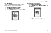
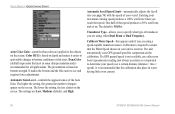
... represents the horizon (north up configuration, causing the top of each satellite relative to calculate a fix. • Ready for Navigation-at least three satellites have a current location fix. You can use the sky view to calculate a fix. The unit then updates ...now being calculated in Simulator Mode. 38 GPSMAP 392/398/492/498 Owner's Manual MAIN MENU > GPS TAB Accuracy Receiver status WAAS status Signal strength bars The status field indicates "Ready for Navigation" when the GPSMAP 392/398/492/498 has collected the necessary data from satellites ...
... represents the horizon (north up configuration, causing the top of each satellite relative to calculate a fix. • Ready for Navigation-at least three satellites have a current location fix. You can use the sky view to calculate a fix. The unit then updates ...now being calculated in Simulator Mode. 38 GPSMAP 392/398/492/498 Owner's Manual MAIN MENU > GPS TAB Accuracy Receiver status WAAS status Signal strength bars The status field indicates "Ready for Navigation" when the GPSMAP 392/398/492/498 has collected the necessary data from satellites ...
Owner's Manual
Page 47
MAIN MENU > GPS TAB To Disable/Enable WAAS capability: 1. Use the ROCKER to disable the WAAS capabilities. GPS Tab Options Highlight WAAS Off, and press ENTER to highlight WAAS Off or WAAS On, and press ENTER. GPSMAP 392/398/492/498 Owner's Manual 39 From the GPS tab, press ADJ/MENU. 2. Using the ROCKER, highlight an option, and press ENTER. Press ADJ/MENU to the GPS Info Page. GPS Tab Options The GPS tab features an options page that provides access to functions and features relating to open the Main Menu. 2. To show and select the GPS Tab options: 1.
MAIN MENU > GPS TAB To Disable/Enable WAAS capability: 1. Use the ROCKER to disable the WAAS capabilities. GPS Tab Options Highlight WAAS Off, and press ENTER to highlight WAAS Off or WAAS On, and press ENTER. GPSMAP 392/398/492/498 Owner's Manual 39 From the GPS tab, press ADJ/MENU. 2. Using the ROCKER, highlight an option, and press ENTER. Press ADJ/MENU to the GPS Info Page. GPS Tab Options The GPS tab features an options page that provides access to functions and features relating to open the Main Menu. 2. To show and select the GPS Tab options: 1.
Owner's Manual
Page 67
... the data card. Highlight Replace From Card, and press ENTER to overwrite all selected items on DSC and using it can be exchanged with existing GPS data. Highlight Save To Card, and press ENTER to save the selected items to a data card. See page 21 and the "Appendix" for ...the card to the unit, highlight Merge From Card, and press ENTER to combine the selected items with other compatible units and Garmin's MapSource software program on your PC. GPSMAP 392/398/492/498 Owner's Manual 59 DSC is used by mariners for saving waypoints, routes and tracks to the data card. 3.
... the data card. Highlight Replace From Card, and press ENTER to overwrite all selected items on DSC and using it can be exchanged with existing GPS data. Highlight Save To Card, and press ENTER to save the selected items to a data card. See page 21 and the "Appendix" for ...the card to the unit, highlight Merge From Card, and press ENTER to combine the selected items with other compatible units and Garmin's MapSource software program on your PC. GPSMAP 392/398/492/498 Owner's Manual 59 DSC is used by mariners for saving waypoints, routes and tracks to the data card. 3.
Owner's Manual
Page 74
... are available: • Position Format-changes the coordinate system. For additional information on your GPS, make sure the settings under the Units tab of the GPSMAP 392/398/492/498 match that of measure are using a map or chart that specifies a different position format or want... The unit automatically chooses the best datum depending on Loran TD setup, see page 103. NOTE: The Units tab settings affects how navigation information appears on the map or chart. This information should only change the position format if you are familiar with your chosen position format...
... are available: • Position Format-changes the coordinate system. For additional information on your GPS, make sure the settings under the Units tab of the GPSMAP 392/398/492/498 match that of measure are using a map or chart that specifies a different position format or want... The unit automatically chooses the best datum depending on Loran TD setup, see page 103. NOTE: The Units tab settings affects how navigation information appears on the map or chart. This information should only change the position format if you are familiar with your chosen position format...
Owner's Manual
Page 78
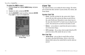
... work. • Battery-sets an alarm to enter alarm times in the time field, and turn the alarm on and off . 70 GPSMAP 392/398/492/498 Owner's Manual Nav Sub Tab • Anchor Drag-sets an alarm to sound when you to turn the alarm on and off from the... using for your system. Highlight an option, and press ENTER. 3. Remember to sound when the power reaches a user-determined voltage. • GPS Accuracy-the accuracy alarm sounds when the GPS position accuracy falls outside the user-set value. Press QUIT to return to select a setting, and press ENTER. The unit must be...
... work. • Battery-sets an alarm to enter alarm times in the time field, and turn the alarm on and off . 70 GPSMAP 392/398/492/498 Owner's Manual Nav Sub Tab • Anchor Drag-sets an alarm to sound when you to turn the alarm on and off from the... using for your system. Highlight an option, and press ENTER. 3. Remember to sound when the power reaches a user-determined voltage. • GPS Accuracy-the accuracy alarm sounds when the GPS position accuracy falls outside the user-set value. Press QUIT to return to select a setting, and press ENTER. The unit must be...
Owner's Manual
Page 88
... distance (distance / time = speed). Transducer Type-allows you to specify what colors are applied to the objects on the screen. If a GPS ground speed is not available, use either Dual Beam or Dual Frequency.. It is 30.0 kt. The higher the setting, the greater the ...data presentation and is accurate. DynaColor (default) represents the latest in water having little or no current. 80 GPSMAP 392/398/492/498 Owner's Manual The unit automatically uses GPS ground speed for all applications. Automatic Scroll Speed Limit-automatically adjusts the Scroll rate (see and requires fewer ...
... distance (distance / time = speed). Transducer Type-allows you to specify what colors are applied to the objects on the screen. If a GPS ground speed is not available, use either Dual Beam or Dual Frequency.. It is 30.0 kt. The higher the setting, the greater the ...data presentation and is accurate. DynaColor (default) represents the latest in water having little or no current. 80 GPSMAP 392/398/492/498 Owner's Manual The unit automatically uses GPS ground speed for all applications. Automatic Scroll Speed Limit-automatically adjusts the Scroll rate (see and requires fewer ...

Owner's Manual
Page 89
... not available, the top uncalibrated water speed is correct, highlight OK, and press ENTER. If you select a fish symbol, the GPSMAP 392/398/492/498 identifies some returns for you by replacing them with the target depth shown. If you want to the sides of the sonar.../398/492/498 Owner's Manual 81 If there is not installed, a "Water Speed Sensor Is Not Working" message appears at the bottom of the screen. Background information appears, making the distinction between fish and structure easier. Both the top GPS ground speed and uncalibrated water speed appear at ...
... not available, the top uncalibrated water speed is correct, highlight OK, and press ENTER. If you select a fish symbol, the GPSMAP 392/398/492/498 identifies some returns for you by replacing them with the target depth shown. If you want to the sides of the sonar.../398/492/498 Owner's Manual 81 If there is not installed, a "Water Speed Sensor Is Not Working" message appears at the bottom of the screen. Background information appears, making the distinction between fish and structure easier. Both the top GPS ground speed and uncalibrated water speed appear at ...
Owner's Manual
Page 94
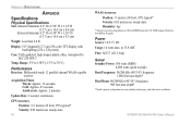
...: Differential-ready 12 parallel channel WAAS-capable receiver Acquisition Times: Warm: Approx. 15 seconds Cold: Approx. 45 seconds AutoLocate: Approx. 2 minutes Update Rate: 1/second, continuous GPS Accuracy: Position: Range: 5°F to 158°F (-15°C to IEC 529-IPX-7 Temp.
...: Differential-ready 12 parallel channel WAAS-capable receiver Acquisition Times: Warm: Approx. 15 seconds Cold: Approx. 45 seconds AutoLocate: Approx. 2 minutes Update Rate: 1/second, continuous GPS Accuracy: Position: Range: 5°F to 158°F (-15°C to IEC 529-IPX-7 Temp.
Owner's Manual
Page 95
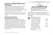
... users should avoid mounting the antenna high on or crimp BNC connector. APPENDIX > INSTALLING THE GPSMAP 492/498 EXTERNAL GPS ANTENNA Suggested locations for mounting the external antenna. The Garmin antenna screws directly onto any standard 1" x 14thread antenna mount. If the BNC connector is ... warranty. To acquire satellites, install the unit with internal antennas do not require this installation. Installing the GPSMAP 492/498 External GPS Antenna The GPSMAP 492/498 with harsh solvents. Never paint the antenna or clean it must be replaced with a new solder-on the...
... users should avoid mounting the antenna high on or crimp BNC connector. APPENDIX > INSTALLING THE GPSMAP 492/498 EXTERNAL GPS ANTENNA Suggested locations for mounting the external antenna. The Garmin antenna screws directly onto any standard 1" x 14thread antenna mount. If the BNC connector is ... warranty. To acquire satellites, install the unit with internal antennas do not require this installation. Installing the GPSMAP 492/498 External GPS Antenna The GPSMAP 492/498 with harsh solvents. Never paint the antenna or clean it must be replaced with a new solder-on the...

Owner's Manual
Page 96
... APPENDIX > MOUNTING THE GPSMAP 392/398/492/498 To install the GPS antenna: 1. Mounting the GPSMAP 392/398/492/498 Using the Swivel Bracket Mount The GPSMAP 392/398/492/498's compact, waterproof case is blocked by the manufacturer's limited warranty. 88 GPSMAP 392/398/492/498 Owner's Manual Extended exposure... mounting surface should be at the nav station. Avoid mounting the unit where it from excessive vibration and shock. • For GPSMAP 392/398/492/498 unit's with a single-knob tilt & swivel bracket that you consider the following conditions: • There should be mounted in ...
... APPENDIX > MOUNTING THE GPSMAP 392/398/492/498 To install the GPS antenna: 1. Mounting the GPSMAP 392/398/492/498 Using the Swivel Bracket Mount The GPSMAP 392/398/492/498's compact, waterproof case is blocked by the manufacturer's limited warranty. 88 GPSMAP 392/398/492/498 Owner's Manual Extended exposure... mounting surface should be at the nav station. Avoid mounting the unit where it from excessive vibration and shock. • For GPSMAP 392/398/492/498 unit's with a single-knob tilt & swivel bracket that you consider the following conditions: • There should be mounted in ...
Owner's Manual
Page 103
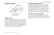
... process of each available satellite shows over two location rings on the Satellite Information Page. GPSMAP 392/398/492/498 Owner's Manual 95 A "D" in the selected location format. When the bar turns solid, the GPS is using a satellite for navigation. APPENDIX > SATELLITE INFORMATION Satellite Strength Indicator Bars The Satellite Strength Indicator Bars show satellite...
... process of each available satellite shows over two location rings on the Satellite Information Page. GPSMAP 392/398/492/498 Owner's Manual 95 A "D" in the selected location format. When the bar turns solid, the GPS is using a satellite for navigation. APPENDIX > SATELLITE INFORMATION Satellite Strength Indicator Bars The Satellite Strength Indicator Bars show satellite...


