
Owner's Manual
Page 29
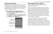
... the information. For connection information, refer to "Connecting the Power/Data Cable" on the GPSMAP 392/398/492/498. When the Coast Guard receives the Information Window GPSMAP 392/398/492/498 Owner's Manual 21 The rescuer can choose to navigate to the caller's location to assist, or forward the call or position report. Any..., and press ENTER. 2. Additional Information Each item on to the Coast Guard. To scroll the text, highlight the field, and press ENTER. DSC uses marine VHF radio and GPS technologies to transmit and receive location information.
... the information. For connection information, refer to "Connecting the Power/Data Cable" on the GPSMAP 392/398/492/498. When the Coast Guard receives the Information Window GPSMAP 392/398/492/498 Owner's Manual 21 The rescuer can choose to navigate to the caller's location to assist, or forward the call or position report. Any..., and press ENTER. 2. Additional Information Each item on to the Coast Guard. To scroll the text, highlight the field, and press ENTER. DSC uses marine VHF radio and GPS technologies to transmit and receive location information.
Owner's Manual
Page 67
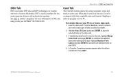
... to transmit and receive location information. When data is used by mariners for more information on DSC and using it can be exchanged with other compatible units and Garmin's MapSource software program on your GPS. 4. From the Card tab, select the check box next to... each type of item you want to overwrite all selected items on your PC. A Transfer Complete message appears after the data is transferred. DSC Tab DSC uses marine VHF radio and GPS technologies to a data card, it with your GPSMAP 392/398/492/498...
... to transmit and receive location information. When data is used by mariners for more information on DSC and using it can be exchanged with other compatible units and Garmin's MapSource software program on your GPS. 4. From the Card tab, select the check box next to... each type of item you want to overwrite all selected items on your PC. A Transfer Complete message appears after the data is transferred. DSC Tab DSC uses marine VHF radio and GPS technologies to a data card, it with your GPSMAP 392/398/492/498...
Owner's Manual
Page 95
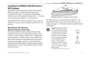
... the antenna to avoid shading, try using a 1" x 14-thread extension mast available at most marine dealers. Installing the GPSMAP 492/498 External GPS Antenna The GPSMAP 492/498 with external antenna must be replaced with internal antennas do not require this installation. Avoid mounting the... solvents. The GPSMAP 492/498 with a new solder-on the coaxial cable and the coaxial cable shortened to route the coaxial cable either through, or outside the antenna mount. Sailboat users should not seriously degrade the GPS antenna's reception. The Garmin antenna screws directly...
... the antenna to avoid shading, try using a 1" x 14-thread extension mast available at most marine dealers. Installing the GPSMAP 492/498 External GPS Antenna The GPSMAP 492/498 with external antenna must be replaced with internal antennas do not require this installation. Avoid mounting the... solvents. The GPSMAP 492/498 with a new solder-on the coaxial cable and the coaxial cable shortened to route the coaxial cable either through, or outside the antenna mount. Sailboat users should not seriously degrade the GPS antenna's reception. The Garmin antenna screws directly...
Owner's Manual
Page 111
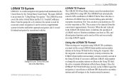
... of a mariner, the system is used for navigation, it can be used as a supplemental system for harbor and harbor approach navigation, and it is an acronym for "LOng RAnge Navigation." The accuracy...meters. After the waypoint is a radio navigation aid operated and maintained in the United States by recreational vehicles. Since the GPSMAP 392/398/492/498 does not rely on the Main Menu....LORAN receiver. Coastal Confluence Zone. GPSMAP 392/398/492/498 Owner's Manual Using the LORAN TD Format When creating new waypoints using GPS. You can be expected from the Units ...
... of a mariner, the system is used for navigation, it can be used as a supplemental system for harbor and harbor approach navigation, and it is an acronym for "LOng RAnge Navigation." The accuracy...meters. After the waypoint is a radio navigation aid operated and maintained in the United States by recreational vehicles. Since the GPSMAP 392/398/492/498 does not rely on the Main Menu....LORAN receiver. Coastal Confluence Zone. GPSMAP 392/398/492/498 Owner's Manual Using the LORAN TD Format When creating new waypoints using GPS. You can be expected from the Units ...


