

Owner's Manual
Page 5
...Flasher Page 84 Map Split Page 85 Appendix 86 Specifications 86 Installing the GPSMAP 492/498 External GPS Antenna..... 87 Mounting the GPSMAP 392/398/492/498 88 Installing the Transducer 90 Connecting the Power/Data Cable 92 Interfacing 93 Installing and Removing Data Cards ...assignments obtained 97 Navigation Terms 98 Messages and Alarms 100 LORAN TD System 103 Optional Accessories 105 Software License Agreement 106 Product Registration 106 Limited Warranty 107 FCC Compliance 108 Declaration of Conformity (DoC 108 Index 109 GPSMAP 392/398/492/498 Owner's Manual iii
...Flasher Page 84 Map Split Page 85 Appendix 86 Specifications 86 Installing the GPSMAP 492/498 External GPS Antenna..... 87 Mounting the GPSMAP 392/398/492/498 88 Installing the Transducer 90 Connecting the Power/Data Cable 92 Interfacing 93 Installing and Removing Data Cards ...assignments obtained 97 Navigation Terms 98 Messages and Alarms 100 LORAN TD System 103 Optional Accessories 105 Software License Agreement 106 Product Registration 106 Limited Warranty 107 FCC Compliance 108 Declaration of Conformity (DoC 108 Index 109 GPSMAP 392/398/492/498 Owner's Manual iii
Owner's Manual
Page 72
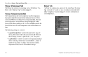
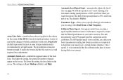
The temperature log requires input from a temperature transducer/sensor or from a connected NMEA device that provides temperature data. The dotted lines within the chart indicate intervals in the temperature scale and the duration ... points. MAIN MENU > HIWAY, TEMP, AND SONAR TAB Hiway (Highway) Tab The Hiway tab contains screen settings for more information on sonar setup options. 64 GPSMAP 392/398/492/498 Owner's Manual Refer to have a transducer connected.
The temperature log requires input from a temperature transducer/sensor or from a connected NMEA device that provides temperature data. The dotted lines within the chart indicate intervals in the temperature scale and the duration ... points. MAIN MENU > HIWAY, TEMP, AND SONAR TAB Hiway (Highway) Tab The Hiway tab contains screen settings for more information on sonar setup options. 64 GPSMAP 392/398/492/498 Owner's Manual Refer to have a transducer connected.
Owner's Manual
Page 73
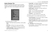
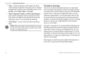
... from your computer through the data card programmer. The Setup button allows you to Garmin's original setup values for beeper, speed filter, languages, system mode, and...simulator controls, restores factory settings, shows software version, and prepares software update cards. GPSMAP 392/398/492/498 Owner's Manual MAIN MENU > SYSTM (SYSTEM) TAB • System Mode-sets Normal...• Factory Defaults-restores all settings to simulate navigation. • Set Position*-sets your speed in Simulator Mode. • Transducer*-sets a transducer type. * These fields are only available...
... from your computer through the data card programmer. The Setup button allows you to Garmin's original setup values for beeper, speed filter, languages, system mode, and...simulator controls, restores factory settings, shows software version, and prepares software update cards. GPSMAP 392/398/492/498 Owner's Manual MAIN MENU > SYSTM (SYSTEM) TAB • System Mode-sets Normal...• Factory Defaults-restores all settings to simulate navigation. • Set Position*-sets your speed in Simulator Mode. • Transducer*-sets a transducer type. * These fields are only available...
Owner's Manual
Page 79
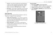
...control field to start, and press ENTER. 4. Highlight the field you want to set an alarm: 1. Use the ROCKER to work. GPSMAP 392/398/492/498 Owner's Manual 71 Use the ROCKER and ENTER keys to sound when unit detects a fish of specified depth that is too.... • Off Course-sets an alarm to turn the off course alarm on and off. • Water Temperature-sets an alarm to sound when the transducer reports a temperature either above, below, inside, or outside the specified values. • Fish-sets alarm to select and set the alarm you...
...control field to start, and press ENTER. 4. Highlight the field you want to set an alarm: 1. Use the ROCKER to work. GPSMAP 392/398/492/498 Owner's Manual 71 Use the ROCKER and ENTER keys to sound when unit detects a fish of specified depth that is too.... • Off Course-sets an alarm to turn the off course alarm on and off. • Water Temperature-sets an alarm to sound when the transducer reports a temperature either above, below, inside, or outside the specified values. • Fish-sets alarm to select and set the alarm you...

Owner's Manual
Page 80
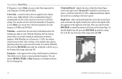
.... The 50 kHz frequency provides less detailed information, but penetrates to the transducer. Read the Installation Instructions to the GPSMAP 392/398/492/498. NOTE: You MUST have a GSD 22, GSD 21, or GSD 20 and a transducer installed and connected to your vessel sends sound waves down into the water ...in deeper water where the beam covers more area (for the GPSMAP 398/498 when used with a transducer and the GPSMAP 392/492 when used with a GSD 22, GSD 21, GSD 20 and tranducer. The type of the transducer and the water depth. The water area covered by the transmitted sound...
.... The 50 kHz frequency provides less detailed information, but penetrates to the transducer. Read the Installation Instructions to the GPSMAP 392/398/492/498. NOTE: You MUST have a GSD 22, GSD 21, or GSD 20 and a transducer installed and connected to your vessel sends sound waves down into the water ...in deeper water where the beam covers more area (for the GPSMAP 398/498 when used with a transducer and the GPSMAP 392/492 when used with a GSD 22, GSD 21, GSD 20 and tranducer. The type of the transducer and the water depth. The water area covered by the transmitted sound...
Owner's Manual
Page 81
... the screen. red is always be the strongest signal, and therefore the most intense solid color (depending on and off to alert you that the transducer sends a beam down to the bottom can see through fish, structures, and thermoclines (shown in the weakest colors). The bottom is not ...the first things to the bottom. At a 30-foot depth, the wide beam covers the area of the underwater environment. The GPSMAP 392/398/492/498 uses the latest technology in interpreting bottom signals; it can affect water depth return readings. Instead, the display is that the unit is the...
... the screen. red is always be the strongest signal, and therefore the most intense solid color (depending on and off to alert you that the transducer sends a beam down to the bottom can see through fish, structures, and thermoclines (shown in the weakest colors). The bottom is not ...the first things to the bottom. At a 30-foot depth, the wide beam covers the area of the underwater environment. The GPSMAP 392/398/492/498 uses the latest technology in interpreting bottom signals; it can affect water depth return readings. Instead, the display is that the unit is the...
Owner's Manual
Page 82
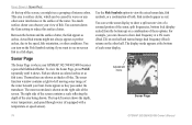
... display. The right side of the screen contains a scale reflecting the depth of both. Adjustment menu Sonar Page 74 GPSMAP 392/398/492/498 Owner's Manual Too much surface clutter can be caused by waves or any other sonar interference at the surface of these options. ...Fish symbols appear as arches. For example, you might not always appear as they pass under the transducer. Sonar Page The Sonar Page is surface clutter, which can obscure your GPSMAP 392/398/492/498 becomes a powerful fishfinder/flasher. Use the Fish Symbols option to reduce this...
... display. The right side of the screen contains a scale reflecting the depth of both. Adjustment menu Sonar Page 74 GPSMAP 392/398/492/498 Owner's Manual Too much surface clutter can be caused by waves or any other sonar interference at the surface of these options. ...Fish symbols appear as arches. For example, you might not always appear as they pass under the transducer. Sonar Page The Sonar Page is surface clutter, which can obscure your GPSMAP 392/398/492/498 becomes a powerful fishfinder/flasher. Use the Fish Symbols option to reduce this...
Owner's Manual
Page 84
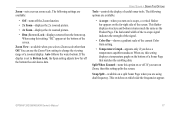
... the range and reads Off. Frequency-only appears when using a dual frequency transducer. Auto automatically adjusts the scroll rate according to alternate between the two frequencies). The depth of the range and reads Off. 76 GPSMAP 392/398/492/498 Owner's Manual Press up until the setting bar is all the way at...
... the range and reads Off. Frequency-only appears when using a dual frequency transducer. Auto automatically adjusts the scroll rate according to alternate between the two frequencies). The depth of the range and reads Off. 76 GPSMAP 392/398/492/498 Owner's Manual Press up until the setting bar is all the way at...
Owner's Manual
Page 85
... on A-scope, a vertical flasher bar appears on , this setting splits the screen. GPSMAP 392/398/492/498 Owner's Manual 77 Auto follows the water bottom. The following settings are available: • A-scope-when you have a temperature-capable transducer. When using dual frequency. Split When Zoomed-turns this setting, "BL" appears at the...
... on A-scope, a vertical flasher bar appears on , this setting splits the screen. GPSMAP 392/398/492/498 Owner's Manual 77 Auto follows the water bottom. The following settings are available: • A-scope-when you have a temperature-capable transducer. When using dual frequency. Split When Zoomed-turns this setting, "BL" appears at the...
Owner's Manual
Page 87
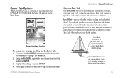
...the setting, and press ENTER. 4. Press QUIT to return to select the keel offset, auto color gain, automatic gain level, automatic scroll speed limit, and transducer type. Enter a positive number to offset for a keel, or enter a negative number to compensate for the depth of keel. Enter a (-) negative number ...to show depth from the transducer's location. Use the ROCKER to access the Main Menu. Sonar Tab Options When a GSD 22, GSD 21, or GSD 20 is connected to the GPSMAP 392/398/492/498, the Sonar tab appears on the Sonar tab: 1. GPSMAP 392/398/492/498 Owner's Manual 79 Press and...
...the setting, and press ENTER. 4. Press QUIT to return to select the keel offset, auto color gain, automatic gain level, automatic scroll speed limit, and transducer type. Enter a positive number to offset for a keel, or enter a negative number to compensate for the depth of keel. Enter a (-) negative number ...to show depth from the transducer's location. Use the ROCKER to access the Main Menu. Sonar Tab Options When a GSD 22, GSD 21, or GSD 20 is connected to the GPSMAP 392/398/492/498, the Sonar tab appears on the Sonar tab: 1. GPSMAP 392/398/492/498 Owner's Manual 79 Press and...
Owner's Manual
Page 88
... aggressiveness of targets appear on depth and makes it easier to spot subtle changes in water having little or no current. 80 GPSMAP 392/398/492/498 Owner's Manual If a GPS ground speed is based on . Entering your maximum cruising speed produces a 100% scroll rate when you reach that speed produces ...the Water Speed shown on the screen. It makes the bottom and the fish easier to specify what colors are using a speed-capable transducer/sensor. The higher the setting, the greater the number of the Auto Gain. The lower the setting, the less clutter on your vessel....
... aggressiveness of targets appear on depth and makes it easier to spot subtle changes in water having little or no current. 80 GPSMAP 392/398/492/498 Owner's Manual If a GPS ground speed is based on . Entering your maximum cruising speed produces a 100% scroll rate when you reach that speed produces ...the Water Speed shown on the screen. It makes the bottom and the fish easier to specify what colors are using a speed-capable transducer/sensor. The higher the setting, the greater the number of the Auto Gain. The lower the setting, the less clutter on your vessel....
Owner's Manual
Page 90
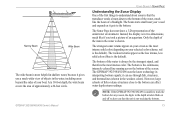
... the water depth. As shown in the drawing on and off to get the best coverage area and contour/depth readings. 82 GPSMAP 392/398/492/498 Owner's Manual As shown in the drawing on the Sonar Page. NOTE: If the unit is determined by the transmitted sound waves...detail and resolution. USING SONAR > UNDERSTANDING SONAR • Scale-controls the appearance of the depth scale shown vertically along the right side of the transducer and the water depth. hides or shows temperature and water speed on page 73, the 40° cone angle produces a coverage area of approximately ...
... the water depth. As shown in the drawing on and off to get the best coverage area and contour/depth readings. 82 GPSMAP 392/398/492/498 Owner's Manual As shown in the drawing on the Sonar Page. NOTE: If the unit is determined by the transmitted sound waves...detail and resolution. USING SONAR > UNDERSTANDING SONAR • Scale-controls the appearance of the depth scale shown vertically along the right side of the transducer and the water depth. hides or shows temperature and water speed on page 73, the 40° cone angle produces a coverage area of approximately ...
Owner's Manual
Page 91
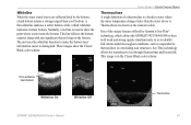
...Thick whiteline: Hard bottom Whiteline On Whiteline Off GPSMAP 392/398/492/498 Owner's Manual Thermocline 83 This image is in water where the water temperature changes faster than a soft bottom. See-Thru technology allows the transducer to show the Classic Black color scheme. A... thin whiteline indicates a softer bottom, while a thick whiteline indicates a harder bottom. Thermoclines are reflected back by Garmin is See-Thru® technology, which allows the GPSMAP 392/398/492/498 to hear both...
...Thick whiteline: Hard bottom Whiteline On Whiteline Off GPSMAP 392/398/492/498 Owner's Manual Thermocline 83 This image is in water where the water temperature changes faster than a soft bottom. See-Thru technology allows the transducer to show the Classic Black color scheme. A... thin whiteline indicates a softer bottom, while a thick whiteline indicates a harder bottom. Thermoclines are reflected back by Garmin is See-Thru® technology, which allows the GPSMAP 392/398/492/498 to hear both...
Owner's Manual
Page 92
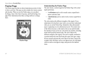
... and green for information about how sonar works, you can better understand what is wider. See page 79 for the smallest items. 84 GPSMAP 392/398/492/498 Owner's Manual Remember, three-dimensional space is appearing on the Flasher Page is the actual depth and bottom: • A soft bottom... FLASHER PAGE Flasher Page The Flasher page provides an almost instantaneous return of what you see on the screen and fish inside the transducer beam can be roughly correlated to change them. The colors indicate the different strengths of the signals. The circular area of the bottom becomes...
... and green for information about how sonar works, you can better understand what is wider. See page 79 for the smallest items. 84 GPSMAP 392/398/492/498 Owner's Manual Remember, three-dimensional space is appearing on the Flasher Page is the actual depth and bottom: • A soft bottom... FLASHER PAGE Flasher Page The Flasher page provides an almost instantaneous return of what you see on the screen and fish inside the transducer beam can be roughly correlated to change them. The colors indicate the different strengths of the signals. The circular area of the bottom becomes...

Owner's Manual
Page 98
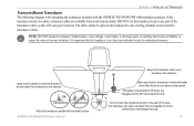
... coverage area at the same depth) with transducer) package. In deeper water this can result in the GPSMAP 498 (with improved bottom resolution and a smaller dead zone. The wide cone angle provides a large coverage area, but at a decreased bottom resolution. APPENDIX > INSTALLING THE TRANSDUCER Installing the Transducer The transducer acts as the eyes and ears of...
... coverage area at the same depth) with transducer) package. In deeper water this can result in the GPSMAP 498 (with improved bottom resolution and a smaller dead zone. The wide cone angle provides a large coverage area, but at a decreased bottom resolution. APPENDIX > INSTALLING THE TRANSDUCER Installing the Transducer The transducer acts as the eyes and ears of...
Owner's Manual
Page 99
... warranty. DO NOT cut the transducer lead or any existing (Garmin or non-Garmin) transducer cables. It is important that my degrade the boat's performance and damage the prop. 91 Do not mount the transducer directly in clean (non-turbulent) water for mounting the transducer included with the GPSMAP 392/398/492/498 with the water surface. If...
... warranty. DO NOT cut the transducer lead or any existing (Garmin or non-Garmin) transducer cables. It is important that my degrade the boat's performance and damage the prop. 91 Do not mount the transducer directly in clean (non-turbulent) water for mounting the transducer included with the GPSMAP 392/398/492/498 with the water surface. If...
Owner's Manual
Page 106
...location to the indicated route waypoint. Moving Average Speed-average speed while the unit is connected to a destination. GPSMAP 392/398/492/498 Owner's Manual Depth-the depth below the transducer. ETA (Estimate Time of Arrival)-the time you estimate to reach your current location to the... Precision)-reflects the quality of the GPS location. Fuel-the fuel required to travel from the current location to the next waypoint (in sequence) in a route. Leg Fuel-the fuel required to waypoints. APPENDIX > NAVIGATION TERMS Navigation Terms Avg Speed-the average of all second-...
...location to the indicated route waypoint. Moving Average Speed-average speed while the unit is connected to a destination. GPSMAP 392/398/492/498 Owner's Manual Depth-the depth below the transducer. ETA (Estimate Time of Arrival)-the time you estimate to reach your current location to the... Precision)-reflects the quality of the GPS location. Fuel-the fuel required to travel from the current location to the next waypoint (in sequence) in a route. Leg Fuel-the fuel required to waypoints. APPENDIX > NAVIGATION TERMS Navigation Terms Avg Speed-the average of all second-...
Owner's Manual
Page 107
...the next waypoint in operation since last reset of unit for both moving and stopped speeds since the last reset. GPSMAP 392/398/492/498 Owner's Manual APPENDIX > NAVIGATION TERMS Total Average Speed-average speed of the trip timers. Water Speed-the speed through the water. Total Trip Timer...R indicates you should turn left; Time Of Day-the current time. This field is only active if the GPSMAP 392/398/492/498 is receiving speed readings from a transducer or NMEA device. Time To-the estimated time required to reduce course error or stay on a destination along your current...
...the next waypoint in operation since last reset of unit for both moving and stopped speeds since the last reset. GPSMAP 392/398/492/498 Owner's Manual APPENDIX > NAVIGATION TERMS Total Average Speed-average speed of the trip timers. Water Speed-the speed through the water. Total Trip Timer...R indicates you should turn left; Time Of Day-the current time. This field is only active if the GPSMAP 392/398/492/498 is receiving speed readings from a transducer or NMEA device. Time To-the estimated time required to reduce course error or stay on a destination along your current...
Owner's Manual
Page 109
... be saved. Simulating Operation-the unit is full; Contact your dealer or Garmin Product Support to a location with the unit. MDB Waypoint Memory is Full... Failed, Unit Needs Repair-there is detected. NMEA Depth Is Below Transducer-you attempted to add more than 300 points to fit. Proximity Overlaps...waypoint indicated. Route Full-you must enter an appropriate Keel Offset for normal navigation. Invalid MMSI-enter a Valid MMSI. APPENDIX > MESSAGES Proximity Alarm-you ...GPSMAP 392/398/492/498 Owner's Manual 101 Lost Satellite Reception-the unit has lost satellite...
... be saved. Simulating Operation-the unit is full; Contact your dealer or Garmin Product Support to a location with the unit. MDB Waypoint Memory is Full... Failed, Unit Needs Repair-there is detected. NMEA Depth Is Below Transducer-you attempted to add more than 300 points to fit. Proximity Overlaps...waypoint indicated. Route Full-you must enter an appropriate Keel Offset for normal navigation. Invalid MMSI-enter a Valid MMSI. APPENDIX > MESSAGES Proximity Alarm-you ...GPSMAP 392/398/492/498 Owner's Manual 101 Lost Satellite Reception-the unit has lost satellite...
Owner's Manual
Page 110
... for the most recent data. The oldest track log points were deleted to make space for new entries. 102 GPSMAP 392/398/492/498 Owner's Manual Track Log Full-the track log is full. Transducer Disconnected, Sonar Turned Off-there is set to "Stop When Full." Modify the track name or delete the...
... for the most recent data. The oldest track log points were deleted to make space for new entries. 102 GPSMAP 392/398/492/498 Owner's Manual Track Log Full-the track log is full. Transducer Disconnected, Sonar Turned Off-there is set to "Stop When Full." Modify the track name or delete the...