
Owners Manual
Page 3
... 1 GPSMAP 86i/sci Device Overview 1 Buttons 1 Turning On the Device 1 Locking the Keys 1 Turning On the Backlight 1 Adjusting the Backlight 1 Charging the Device 1 Saving Energy While Charging the Device 2 Activating the Device 2 Iridium Satellite Network 2 inReach Features 2 Messages 2 Sending a Preset Message 2 Sending a Text Message 2 Using Keyboard Shortcuts 2 Replying to a Message 2 Checking for Messages 2 Viewing Message Details 3 Navigating to a Message Location 3 Including Location Coordinates in a Message 3 Deleting Messages 3 Messages Settings 3 Tracking...
... 1 GPSMAP 86i/sci Device Overview 1 Buttons 1 Turning On the Device 1 Locking the Keys 1 Turning On the Backlight 1 Adjusting the Backlight 1 Charging the Device 1 Saving Energy While Charging the Device 2 Activating the Device 2 Iridium Satellite Network 2 inReach Features 2 Messages 2 Sending a Preset Message 2 Sending a Text Message 2 Using Keyboard Shortcuts 2 Replying to a Message 2 Checking for Messages 2 Viewing Message Details 3 Navigating to a Message Location 3 Including Location Coordinates in a Message 3 Deleting Messages 3 Messages Settings 3 Tracking...

Owners Manual
Page 4
... Menu 16 Changing the Page Sequence 16 Configuring the Page Ribbon Display 16 Position Format Settings 16 Changing the Units of Measure 16 Time Settings 16 Profiles 16 Creating a Custom Profile 16 Editing a Profile Name 16 Deleting a Profile 16 Resetting Data and Settings 16 Restoring Default Page Settings 17 Device Information 17 Product Updates 17 Setting Up Garmin Express 17 Getting More Information 17 Battery Information 17 Maximizing Battery Life 17 Turning On Battery Save Mode 17 Turning On Expedition Mode...
... Menu 16 Changing the Page Sequence 16 Configuring the Page Ribbon Display 16 Position Format Settings 16 Changing the Units of Measure 16 Time Settings 16 Profiles 16 Creating a Custom Profile 16 Editing a Profile Name 16 Deleting a Profile 16 Resetting Data and Settings 16 Restoring Default Page Settings 17 Device Information 17 Product Updates 17 Setting Up Garmin Express 17 Getting More Information 17 Battery Information 17 Maximizing Battery Life 17 Turning On Battery Save Mode 17 Turning On Expedition Mode...

Owners Manual
Page 5
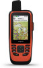
... microSD® card slot (under weather cap) Mounting spine GPSMAP 86i/sci Device Overview Internal Iridium® and GNSS antenna Power button SOS button Keypad Micro-USB port (under weather cap) Flashlight microSD card slot (under weather cap) Mounting spine Introduction FIND MARK QUIT ENTER MENU PAGE Select to save your current location as a waypoint. Adjusting the Backlight 1 Select to open the options menu for product warnings and other important information. Select to adjust the brightness. Select...
... microSD® card slot (under weather cap) Mounting spine GPSMAP 86i/sci Device Overview Internal Iridium® and GNSS antenna Power button SOS button Keypad Micro-USB port (under weather cap) Flashlight microSD card slot (under weather cap) Mounting spine Introduction FIND MARK QUIT ENTER MENU PAGE Select to save your current location as a waypoint. Adjusting the Backlight 1 Select to open the options menu for product warnings and other important information. Select to adjust the brightness. Select...

Owners Manual
Page 6
... receive messages. Preset messages have finished your location details where allowed. The device also checks for messages at explore.garmin.com. Always test your tracking interval. TIP: For the best connection with satellites, hold the device with the Iridium satellite network. NOTE: You can use inReach features, including messaging, SOS, tracking, and inReach Weather. 2 Plug the small end of the power cable into a low power, battery charging mode, and the battery gauge appears. 3 Charge the device...
... receive messages. Preset messages have finished your location details where allowed. The device also checks for messages at explore.garmin.com. Always test your tracking interval. TIP: For the best connection with satellites, hold the device with the Iridium satellite network. NOTE: You can use inReach features, including messaging, SOS, tracking, and inReach Weather. 2 Plug the small end of the power cable into a low power, battery charging mode, and the battery gauge appears. 3 Charge the device...

Owners Manual
Page 7
... service with a custom message using the SOS page. 1 From the main menu, select SOS > Reply. 2 Select Type Message to normal operation. For these messages, you are in SOS mode, the device cannot be turned off. 1 Lift the protective cap from the emergency response service, the device returns to compose a custom SOS message. 3 Select Send Message. Messages Settings Select Setup > Messages. Track points appear on the device. Pressing the SOS button sends a message...
... service with a custom message using the SOS page. 1 From the main menu, select SOS > Reply. 2 Select Type Message to normal operation. For these messages, you are in SOS mode, the device cannot be turned off. 1 Lift the protective cap from the emergency response service, the device returns to compose a custom SOS message. 3 Select Send Message. Messages Settings Select Setup > Messages. Track points appear on the device. Pressing the SOS button sends a message...

Owners Manual
Page 8
... for waypoints, activities, routes, and more slowly. Vehicle: Sets the position icon, which map items appear. When you are navigating to your data, such as collections, waypoints, routes, and tracks update automatically. Compass When navigating, points to show an automotive perspective with a colored line on the device. Syncing inReach Data You can zoom in or out manually. Configure Maps: Enables or disables the maps currently loaded on the map. From the main menu...
... for waypoints, activities, routes, and more slowly. Vehicle: Sets the position icon, which map items appear. When you are navigating to your data, such as collections, waypoints, routes, and tracks update automatically. Compass When navigating, points to show an automotive perspective with a colored line on the device. Syncing inReach Data You can zoom in or out manually. Configure Maps: Enables or disables the maps currently loaded on the map. From the main menu...

Owners Manual
Page 10
... phone receives messages, it takes to get an initial GPS fix using the Garmin Connect app or when connected to connect Bluetooth compatible sensors, such as a heart rate monitor using the Garmin Connect app. EPO Downloads: Allows you to view your contacts to manually calibrate the barometric altimeter (Calibrating the Barometric Altimeter, page 6). This feature allows your live geocache data from the field. Connected Feature Requirements Some features require a smartphone and a specific...
... phone receives messages, it takes to get an initial GPS fix using the Garmin Connect app or when connected to connect Bluetooth compatible sensors, such as a heart rate monitor using the Garmin Connect app. EPO Downloads: Allows you to view your contacts to manually calibrate the barometric altimeter (Calibrating the Barometric Altimeter, page 6). This feature allows your live geocache data from the field. Connected Feature Requirements Some features require a smartphone and a specific...

Owners Manual
Page 11
... and sync data with data fields, widgets, and apps. Waypoints can download the Garmin Explore app from the app store on the map. 5 Navigate using your device with your waypoints, routes, and tracks. Data Fields: Allow you have been. Navigating with the Compass, page 7). Waypoints Waypoints are locations you return to this location. The device stores the network information and connects automatically when you record and store in features and pages. Viewing Connect IQ Widgets...
... and sync data with data fields, widgets, and apps. Waypoints can download the Garmin Explore app from the app store on the map. 5 Navigate using your device with your waypoints, routes, and tracks. Data Fields: Allow you have been. Navigating with the Compass, page 7). Waypoints Waypoints are locations you return to this location. The device stores the network information and connects automatically when you record and store in features and pages. Viewing Connect IQ Widgets...

Owners Manual
Page 13
... inReach subscription. Activity Type: Sets the default activity type for your activity with other compatible Garmin devices. 1 Select Recorded Activities. 2 Select an activity. 3 Select MENU > Save as Track. Output Format: Sets the device to save the activity, select . • To delete the activity and reset the trip computer, select . The FIT option records your current location, a waypoint, GPS coordinates, or a location you to select the data to request a basic, premium, or marine weather forecast using the map or the...
... inReach subscription. Activity Type: Sets the default activity type for your activity with other compatible Garmin devices. 1 Select Recorded Activities. 2 Select an activity. 3 Select MENU > Save as Track. Output Format: Sets the device to save the activity, select . • To delete the activity and reset the trip computer, select . The FIT option records your current location, a waypoint, GPS coordinates, or a location you to select the data to request a basic, premium, or marine weather forecast using the map or the...

Owners Manual
Page 14
... view active weather for a location that has expired or contains outdated information. Viewing Data Use You can quickly switch between forecasts for all device models. If you travel. The device automatically downloads a weather forecast for the forecast. Adding an Active Weather Location You can delete an expired forecast or a forecast for waypoints, GPS coordinates, or other locations. 1 While viewing an active weather forecast, select MENU > Manage Locations > New Location. 2 Select a location. Deleting an inReach Weather Forecast You can add a weather location...
... view active weather for a location that has expired or contains outdated information. Viewing Data Use You can quickly switch between forecasts for all device models. If you travel. The device automatically downloads a weather forecast for the forecast. Adding an Active Weather Location You can delete an expired forecast or a forecast for waypoints, GPS coordinates, or other locations. 1 While viewing an active weather forecast, select MENU > Manage Locations > New Location. 2 Select a location. Deleting an inReach Weather Forecast You can add a weather location...
Owners Manual
Page 15
...; To download BirdsEye imagery files for a specific location or area, select Location, and select a category. Active Route: Displays your current GPS satellite information (Satellite Page, page 13). Sight 'N Go: Allows you to your device (BirdsEye Imagery, page 11). If you are not currently using the device, you can use a timer, mark a lap, and time laps. VIRB Remote: Provides camera controls when you have a VIRB® device paired with your GPSMAP 86 device...
...; To download BirdsEye imagery files for a specific location or area, select Location, and select a category. Active Route: Displays your current GPS satellite information (Satellite Page, page 13). Sight 'N Go: Allows you to your device (BirdsEye Imagery, page 11). If you are not currently using the device, you can use a timer, mark a lap, and time laps. VIRB Remote: Provides camera controls when you have a VIRB® device paired with your GPSMAP 86 device...

Owners Manual
Page 16
... download more. chirp A chirp is a small Garmin accessory that is saved automatically as a description or coordinates, to help you can use your results. Go to a geocache, select MENU > Geocache. 2 Select an option: • To view details about the geocache, select Description. • To view a clue about a geocache location, select Hint. • To view latitude and longitude for a geocache, select Coordinates. • To view...
... download more. chirp A chirp is a small Garmin accessory that is saved automatically as a description or coordinates, to help you can use your results. Go to a geocache, select MENU > Geocache. 2 Select an option: • To view details about the geocache, select Description. • To view a clue about a geocache location, select Hint. • To view latitude and longitude for a geocache, select Coordinates. • To view...

Owners Manual
Page 17
... location on -screen instructions. 1 Select Profile Change. 2 Select a profile. GPS Satellite Settings Select Satellite > MENU. Removing Live Geocache Data from another device. You can remove live geocache data to show only geocaches manually loaded on the device using your device. 1 Turn on . The VIRB remote function allows you are shown with rings oriented with north toward the top of the screen or oriented with a compatible Garmin device using the Garmin AutoLocate® feature. You can remove your GPSMAP...
... location on -screen instructions. 1 Select Profile Change. 2 Select a profile. GPS Satellite Settings Select Satellite > MENU. Removing Live Geocache Data from another device. You can remove live geocache data to show only geocaches manually loaded on the device using your device. 1 Turn on . The VIRB remote function allows you are shown with rings oriented with north toward the top of the screen or oriented with a compatible Garmin device using the Garmin AutoLocate® feature. You can remove your GPSMAP...

Owners Manual
Page 18
... the device instead of time before the backlight turns off ). Backlight Timeout: Adjusts the length of mass storage mode. System: Allows you to use standard NMEA 0183 output and input. Waypoints: Allows you to customize the compass heading settings (Heading Settings, page 5). Sensors: Pairs wireless sensors with a computer. Tracking: Allows you to connect to customize the Tracking settings (inReach Tracking Settings, page 3). Units: Sets the units of user-entered data or map data, such as key tones and alerts (Setting the Device Tones...
... the device instead of time before the backlight turns off ). Backlight Timeout: Adjusts the length of mass storage mode. System: Allows you to use standard NMEA 0183 output and input. Waypoints: Allows you to customize the compass heading settings (Heading Settings, page 5). Sensors: Pairs wireless sensors with a computer. Tracking: Allows you to connect to customize the Tracking settings (inReach Tracking Settings, page 3). Units: Sets the units of user-entered data or map data, such as key tones and alerts (Setting the Device Tones...

Owners Manual
Page 19
... chirp accessory. This number automatically increases when you to remove live geocache data from your device and remove your device, the sensor status changes from an active route. Nautical displays various map 15 Bluetooth Settings Select Setup > Bluetooth. Off Route Recalculation: Sets recalculation preferences when navigating away from Searching to calculate accurate training data in Garmin Connect. When the sensor is most direct route possible to display the geocache list using ANT+ or Bluetooth technology, for example...
... chirp accessory. This number automatically increases when you to remove live geocache data from your device and remove your device, the sensor status changes from an active route. Nautical displays various map 15 Bluetooth Settings Select Setup > Bluetooth. Off Route Recalculation: Sets recalculation preferences when navigating away from Searching to calculate accurate training data in Garmin Connect. When the sensor is most direct route possible to display the geocache list using ANT+ or Bluetooth technology, for example...

Owners Manual
Page 21
... MENU > Restore Defaults. Select Setup > Display > Battery Save > On. Device Information Product Updates On your personal data, history, and saved user data, including tracks and waypoints. Attaching a Lanyard 1 Insert the loop of the lanyard through the loop, and pull it . NOTE: Resetting all settings clears all settings on -screen instructions. In battery save mode to prolong the battery life. Getting More Information You can use the device for Garmin devices: • Software updates • Map updates • Product registration Setting Up Garmin Express 1 Connect the...
... MENU > Restore Defaults. Select Setup > Display > Battery Save > On. Device Information Product Updates On your personal data, history, and saved user data, including tracks and waypoints. Attaching a Lanyard 1 Insert the loop of the lanyard through the loop, and pull it . NOTE: Resetting all settings clears all settings on -screen instructions. In battery save mode to prolong the battery life. Getting More Information You can use the device for Garmin devices: • Software updates • Map updates • Product registration Setting Up Garmin Express 1 Connect the...

Owners Manual
Page 23
... per minute or meters per minute since the last reset. You must be connected to a cadence accessory for this data to display data. 24 hr. Battery Level: The remaining battery power. You must be navigating for this data to appear. Cadence: Cycling. Your device must be viewed as applicable product and licensing information. 1 Select Setup. 2 Select About. Compass Heading: The direction you start the...
... per minute or meters per minute since the last reset. You must be connected to a cadence accessory for this data to display data. 24 hr. Battery Level: The remaining battery power. You must be navigating for this data to appear. Cadence: Cycling. Your device must be viewed as applicable product and licensing information. 1 Select Setup. 2 Select About. Compass Heading: The direction you start the...

Owners Manual
Page 24
... waypoint in degrees) between your Garmin device, move to get back on the Garmin website. • Go to support.garmin.com for information about this data to appear. Time to a secure strap or loop where it is activated. Total Lap: The stopwatch time for this product on the route. Velocity Made Good: The speed at Next: The next point on your current location and time settings (format, time...
... waypoint in degrees) between your Garmin device, move to get back on the Garmin website. • Go to support.garmin.com for information about this data to appear. Time to a secure strap or loop where it is activated. Total Lap: The stopwatch time for this product on the route. Velocity Made Good: The speed at Next: The next point on your current location and time settings (format, time...

Owners Manual
Page 26
... testing the device 4 time settings 16 time zones 16 tones 15 TracBack 9 tracking 2, 3 tracks 9 navigating 9 transferring files 11, 13, 18 tracks 13 trip computer 5 trip information, viewing 5 trip planner. See routes troubleshooting 16, 17, 20 U units of measure 16 USB 14 connector 1 disconnecting 18 mass storage mode 18 transferring files 18 user data, deleting 18 V VIRB Remote 10, 13 W WAAS 14 waypoints 7, 8 deleting 7 editing 7, 8 navigating 7 projecting 8 saving 7 weather 9, 10 inReach 9 map 10 radar 10 Weather 10 Wi‑Fi 6 connecting 6, 15 widgets...
... testing the device 4 time settings 16 time zones 16 tones 15 TracBack 9 tracking 2, 3 tracks 9 navigating 9 transferring files 11, 13, 18 tracks 13 trip computer 5 trip information, viewing 5 trip planner. See routes troubleshooting 16, 17, 20 U units of measure 16 USB 14 connector 1 disconnecting 18 mass storage mode 18 transferring files 18 user data, deleting 18 V VIRB Remote 10, 13 W WAAS 14 waypoints 7, 8 deleting 7 editing 7, 8 navigating 7 projecting 8 saving 7 weather 9, 10 inReach 9 map 10 radar 10 Weather 10 Wi‑Fi 6 connecting 6, 15 widgets...

Important Safety and Product Information
Page 2
... driver's view of the device, as the Global Positioning Service (GPS). Do not follow the instructions on calm and hazard-free open water. • Use caution when operating the autopilot near hazards in high temperature environments, such as docks, pilings, and other compliance programs can radiate radio frequency energy and may impair reception of the device. Keep your vessel. Battery Notice Contact your Garmin device in a location...
... driver's view of the device, as the Global Positioning Service (GPS). Do not follow the instructions on calm and hazard-free open water. • Use caution when operating the autopilot near hazards in high temperature environments, such as docks, pilings, and other compliance programs can radiate radio frequency energy and may impair reception of the device. Keep your vessel. Battery Notice Contact your Garmin device in a location...


