
GPS 12, 12XL, 48, 80 Addendum
Page 1
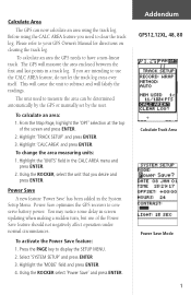
... Save optimizes the GPS receiver to have a non-linear track. Please refer to display the SETUP MENU. 2. Highlight 'CALC AREA' and press ENTER. Addendum GPS12,12XL, 48, 80 Calculate Track Area Power Save Mode 1 Calculate Area The GPS can be determined automatically by the GPS or manually set by the user. Using the ROCKER select 'Power...
... Save optimizes the GPS receiver to have a non-linear track. Please refer to display the SETUP MENU. 2. Highlight 'CALC AREA' and press ENTER. Addendum GPS12,12XL, 48, 80 Calculate Track Area Power Save Mode 1 Calculate Area The GPS can be determined automatically by the GPS or manually set by the user. Using the ROCKER select 'Power...
Owner's Manual (Software Version 2.00-3.62)
Page 2
... - Information in this manual may not be reproduced or transmitted in Taiwan Part Number 190-00134-00 Rev. GARMIN reserves the right to notify any person or organization of GARMIN Corporation and may be used without notice. Printed in any form or by any means including photocopying and recording, for any purpose without...
... - Information in this manual may not be reproduced or transmitted in Taiwan Part Number 190-00134-00 Rev. GARMIN reserves the right to notify any person or organization of GARMIN Corporation and may be used without notice. Printed in any form or by any means including photocopying and recording, for any purpose without...
Owner's Manual (Software Version 2.00-3.62)
Page 3
...; Carrying Case • Quick Reference Guide • 4 AA Batteries See your GARMIN dealer for your dealer immediately. To get the most from your outdoor gear. i INTRODUCTION GPS 12XL Operator's Manual Packing List Thank you for choosing the GARMIN GPS 12XL -the smallest, easiest-to-use GPS navigator for years. Reference provides details about the advanced features and operations...
...; Carrying Case • Quick Reference Guide • 4 AA Batteries See your GARMIN dealer for your dealer immediately. To get the most from your outdoor gear. i INTRODUCTION GPS 12XL Operator's Manual Packing List Thank you for choosing the GARMIN GPS 12XL -the smallest, easiest-to-use GPS navigator for years. Reference provides details about the advanced features and operations...

Owner's Manual (Software Version 2.00-3.62)
Page 4
... and correct the interference by an authorized service center. For safety, always resolve any interference received, including interference that interference will not occur in accordance with all available navigation sources including the information from the GPS 12XL to actual use . Repairs should only be determined by turning the equipment off and on, the user...
... and correct the interference by an authorized service center. For safety, always resolve any interference received, including interference that interference will not occur in accordance with all available navigation sources including the information from the GPS 12XL to actual use . Repairs should only be determined by turning the equipment off and on, the user...
Owner's Manual (Software Version 2.00-3.62)
Page 5
... Page & User Selectable Fields 15-16 Marking a Position & Position Averaging Function 17 Waypoint Pages & Managing Waypoints 18-23 TracBack Navigation 24-25 Creating and Using Routes 26-30 Using the Compass & Highway Pages 31-34 Map Page, Zooming, & Panning 35-38 Map Page & Track Log Setup 38-40 Menu Page & Distance/Sun...
... Page & User Selectable Fields 15-16 Marking a Position & Position Averaging Function 17 Waypoint Pages & Managing Waypoints 18-23 TracBack Navigation 24-25 Creating and Using Routes 26-30 Using the Compass & Highway Pages 31-34 Map Page, Zooming, & Panning 35-38 Map Page & Track Log Setup 38-40 Menu Page & Distance/Sun...
Owner's Manual (Software Version 2.00-3.62)
Page 6
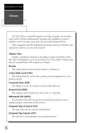
...left to your destination at your arrival at a destination. lites) that is a powerful navigation tool that uses land-based radio beacons to transmit position corrections to GPS receivers. Almanac data must be helpful to review the basic terms and concepts briefly explained below. Desired Track (DTK...in the appropriate reference sections of the GPS system that can begin. Estimated Time of Arrival (ETA) The time of day of satel- INTRODUCTION Glossary The GPS 12XL is transmitted to your receiver from every GPS satellite. Other navigation and GPS definitions used in the manual are off a ...
...left to your destination at your arrival at a destination. lites) that is a powerful navigation tool that uses land-based radio beacons to transmit position corrections to GPS receivers. Almanac data must be helpful to review the basic terms and concepts briefly explained below. Desired Track (DTK...in the appropriate reference sections of the GPS system that can begin. Estimated Time of Arrival (ETA) The time of day of satel- INTRODUCTION Glossary The GPS 12XL is transmitted to your receiver from every GPS satellite. Other navigation and GPS definitions used in the manual are off a ...
Owner's Manual (Software Version 2.00-3.62)
Page 7
... that passes through the north and south poles. Longitude An east/west measurement of the destination. Position An exact, unique location based on a flat surface, using square zones for position measurements. Velocity Made Good (VMG) The speed you are traveling in the direction of position in relation to the Prime Meridian... to another and knowing where you are in relation to your desired course. Track (TRK) The direction of movement relative to measure position in the receiver's memory. 3
... that passes through the north and south poles. Longitude An east/west measurement of the destination. Position An exact, unique location based on a flat surface, using square zones for position measurements. Velocity Made Good (VMG) The speed you are traveling in the direction of position in relation to the Prime Meridian... to another and knowing where you are in relation to your desired course. Track (TRK) The direction of movement relative to measure position in the receiver's memory. 3
Owner's Manual (Software Version 2.00-3.62)
Page 8
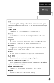
... the unit (see should match the symbol (+ or -) marked on the back of factors, including temperature and backlighting. Contact your GARMIN dealer for remote antennas and accessories. The remote antenna is attached by turning the thumb loop at the base of the unit 1/4 ...still see above). Remove the battery cover by plugging it into position. You may not be used with the GPS 12XL. The remote antenna will improve the receiving capabilities of use . INTRODUCTION Battery Installation Battery Installation Remote Antenna Installation An optional remote antenna may be able ...
... the unit (see should match the symbol (+ or -) marked on the back of factors, including temperature and backlighting. Contact your GARMIN dealer for remote antennas and accessories. The remote antenna is attached by turning the thumb loop at the base of the unit 1/4 ...still see above). Remove the battery cover by plugging it into position. You may not be used with the GPS 12XL. The remote antenna will improve the receiving capabilities of use . INTRODUCTION Battery Installation Battery Installation Remote Antenna Installation An optional remote antenna may be able ...

Owner's Manual (Software Version 2.00-3.62)
Page 9
... the mark position page. L R Moves the selected character field and moves the field highlight from a submenu page to field. DATA ENTRY The arrow keypad is used for GOTO operation. Use the U and D keys to allow data entry. G Displays GOTO page with the waypoint highlighted for all data entry.... use the L and R keys to confirm your entry. 5 sor forward or backward along the line. Pressing GOTO twice activates MOB. Press E to move the cur- P Scrolls ...
... the mark position page. L R Moves the selected character field and moves the field highlight from a submenu page to field. DATA ENTRY The arrow keypad is used for GOTO operation. Use the U and D keys to allow data entry. G Displays GOTO page with the waypoint highlighted for all data entry.... use the L and R keys to confirm your entry. 5 sor forward or backward along the line. Pressing GOTO twice activates MOB. Press E to move the cur- P Scrolls ...
Owner's Manual (Software Version 2.00-3.62)
Page 10
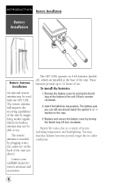
J Satellite Position Map Compass Menu Q Satellite Page The Satellite Page will show you to each satellite being used for the GPS 12XL. Knowing satellite positions will allow you the direction of the page shows your heading. The rest of any ...the inner circle is a graphic representation of signal strength bars corresponding to monitor satellite signal reception and strength. Your track and speed are displayed using two circles and a center point. Satellite positions are indicated immediately below. ! Switch between pages by pressing either the Q or J keys. ...
J Satellite Position Map Compass Menu Q Satellite Page The Satellite Page will show you to each satellite being used for the GPS 12XL. Knowing satellite positions will allow you the direction of the page shows your heading. The rest of any ...the inner circle is a graphic representation of signal strength bars corresponding to monitor satellite signal reception and strength. Your track and speed are displayed using two circles and a center point. Satellite positions are indicated immediately below. ! Switch between pages by pressing either the Q or J keys. ...
Owner's Manual (Software Version 2.00-3.62)
Page 11
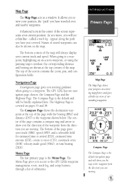
...always display your track (TRK), speed (SPD), and a selectable field for estimated time to arrival (ETA), estimated time enroute (ETE), course to the GPS 12XL's waypoint management, route, track log, and setup features through a list of the map will see a thin line - A diamond icon in the ...is covered on -screen waypoint, or using the panning target crosshair, the corresponding distance and bearing are shown at the top of stored waypoints can also be briefly explained here. When going to view your progress on the map. The GPS 12XL has two navigation page choices: the...
...always display your track (TRK), speed (SPD), and a selectable field for estimated time to arrival (ETA), estimated time enroute (ETE), course to the GPS 12XL's waypoint management, route, track log, and setup features through a list of the map will see a thin line - A diamond icon in the ...is covered on -screen waypoint, or using the panning target crosshair, the corresponding distance and bearing are shown at the top of stored waypoints can also be briefly explained here. When going to view your progress on the map. The GPS 12XL has two navigation page choices: the...
Owner's Manual (Software Version 2.00-3.62)
Page 12
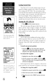
...M key. If these settings have to mark a position as a waypoint. (Your GPS 12XL can use our GPS 12XL to guide us somewhere, we can hold up to 500 waypoints.) To mark your GPS 12XL. Press B until the receiver turns on and that you the basics about marking and going to places called waypoints.... Marking a Position GPS is complete, the Satellite Page will appear. Each...
...M key. If these settings have to mark a position as a waypoint. (Your GPS 12XL can use our GPS 12XL to guide us somewhere, we can hold up to 500 waypoints.) To mark your GPS 12XL. Press B until the receiver turns on and that you the basics about marking and going to places called waypoints.... Marking a Position GPS is complete, the Satellite Page will appear. Each...
Owner's Manual (Software Version 2.00-3.62)
Page 13
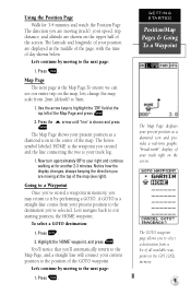
... GOTO waypoint. Let's continue by moving at for 3-4 minutes and watch the Position Page. You'll notice that you 've stored a waypoint in the GPS 12XL's memory. 9 Use the arrow keys to our starting position, the HOME waypoint. The Map Page shows your track right on the map, lets change the map scale... we can see right). The GOTO waypoint page allows you to the destination you created and the line connecting the two is shown and press E. Using the Position Page Walk for another 2-3 minutes.
... GOTO waypoint. Let's continue by moving at for 3-4 minutes and watch the Position Page. You'll notice that you 've stored a waypoint in the GPS 12XL's memory. 9 Use the arrow keys to our starting position, the HOME waypoint. The Map Page shows your track right on the map, lets change the map scale... we can see right). The GOTO waypoint page allows you to the destination you created and the line connecting the two is shown and press E. Using the Position Page Walk for another 2-3 minutes.
Owner's Manual (Software Version 2.00-3.62)
Page 14
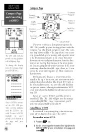
If the arrow points any other direction (left, right, down, etc.), turn toward the arrow until the GOTO is cancel the GOTO. Use the arrow keypad to move the field highlight to the 'CANCEL GOTO' prompt at the bottom of navigation information. The "compass ring" in...Over Ground Track Over Ground Selectable Field Whenever you are shown below. To change the display from the direction you select a destination waypoint, the GPS 12XL provides graphic steering guidance with the Compass Page (the default navigation page). The arrow shows the direction of the page and press E. Once you...
If the arrow points any other direction (left, right, down, etc.), turn toward the arrow until the GOTO is cancel the GOTO. Use the arrow keypad to move the field highlight to the 'CANCEL GOTO' prompt at the bottom of navigation information. The "compass ring" in...Over Ground Track Over Ground Selectable Field Whenever you are shown below. To change the display from the direction you select a destination waypoint, the GPS 12XL provides graphic steering guidance with the Compass Page (the default navigation page). The arrow shows the direction of the page and press E. Once you...
Owner's Manual (Software Version 2.00-3.62)
Page 15
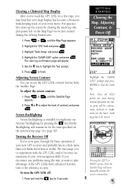
... and press E. To adjust the screen contrast: 1. Backlighting will be stored. Note: Once all 1024 points are used the GPS 12XL for a few trips, you to experiment with the GPS 12XL until it works. Screen Backlighting Screen backlighting is available for 3 seconds. Press E to clear the track log. ... on the system setup page (See page 42). Turning the Receiver Off You've now gone through the basic operation of your new GPS receiver and probably know a little more than you encounter any problems using the unit or want to take advantage of contrast, and press...
... and press E. To adjust the screen contrast: 1. Backlighting will be stored. Note: Once all 1024 points are used the GPS 12XL for a few trips, you to experiment with the GPS 12XL until it works. Screen Backlighting Screen backlighting is available for 3 seconds. Press E to clear the track log. ... on the system setup page (See page 42). Turning the Receiver Off You've now gone through the basic operation of your new GPS receiver and probably know a little more than you encounter any problems using the unit or want to take advantage of contrast, and press...
Owner's Manual (Software Version 2.00-3.62)
Page 16
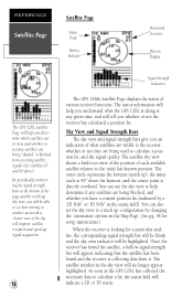
...signal strength bars give you whether or not the receiver has calculated a position fix. and the center point is 45º above ). REFERENCE Satellite Page Satellite Page Status Field Battery Indicator Horizontal Accuracy Skyview Display The GPS 12XL Satellite Page will appear, indicating that the satellite... sky will tell you an indication of what the GPS 12XL is doing at the bottom of various receiver functions. By periodically monitoring the signal strength bars at any satellites are being used to a track up ); You can use the sky view to help you will be highlighted....
...signal strength bars give you whether or not the receiver has calculated a position fix. and the center point is 45º above ). REFERENCE Satellite Page Satellite Page Status Field Battery Indicator Horizontal Accuracy Skyview Display The GPS 12XL Satellite Page will appear, indicating that the satellite... sky will tell you an indication of what the GPS 12XL is doing at the bottom of various receiver functions. By periodically monitoring the signal strength bars at any satellites are being used to a track up ); You can use the sky view to help you will be highlighted....
Owner's Manual (Software Version 2.00-3.62)
Page 17
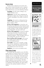
... collected enough data to calculate a 2D fix. 2D Nav (2D Navigation)- at least four satellites with the receiver off , reinitialize the unit to your position is useful if you are receiving DGPS corrections in searching, AutoLocate, acquiring, simulator, or poor coverage mode.) This allows you to be in ...& EZinit The signal strength bars at the bottom of the page will be shown as one of the page, with the receiver off and must be initialized. the GPS 12XL is indoors. This process can take 5 minutes, depending on to the EZinit prompt whenever a position fix has not been ...
... collected enough data to calculate a 2D fix. 2D Nav (2D Navigation)- at least four satellites with the receiver off , reinitialize the unit to your position is useful if you are receiving DGPS corrections in searching, AutoLocate, acquiring, simulator, or poor coverage mode.) This allows you to be in ...& EZinit The signal strength bars at the bottom of the page will be shown as one of the page, with the receiver off and must be initialized. the GPS 12XL is indoors. This process can take 5 minutes, depending on to the EZinit prompt whenever a position fix has not been ...
Owner's Manual (Software Version 2.00-3.62)
Page 18
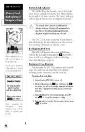
...E to turn the unit on during daylight hours. The GPS 12XL features an internal lithium battery that the GPS 12XL is turned off batteries or external power. Activate the backlight by pressing the B key briefly. A warning message will dis- Use the icon to the left of the sky view, which...be deleted, including: routes, waypoints, and the track log. Emergency Erase Function You may erase the GPS 12XL's memory in four quick steps. Ensure that will maintain the unit's memory when the receiver is not running off . 2. Note: A bulb icon will appear on the Satellite Page when ...
...E to turn the unit on during daylight hours. The GPS 12XL features an internal lithium battery that the GPS 12XL is turned off batteries or external power. Activate the backlight by pressing the B key briefly. A warning message will dis- Use the icon to the left of the sky view, which...be deleted, including: routes, waypoints, and the track log. Emergency Erase Function You may erase the GPS 12XL's memory in four quick steps. Ensure that will maintain the unit's memory when the receiver is not running off . 2. Note: A bulb icon will appear on the Satellite Page when ...
Owner's Manual (Software Version 2.00-3.62)
Page 19
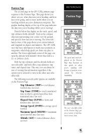
...graphic heading display at slow speeds (or when you from . 15 Trip Timer (TTIME)- hours and minutes since last reset. The GPS 12XL uses this display are available on the Position Page: Trip Odometer (TRIP)- Both the trip odometer and the altitude fields are traveling without an...may fluctuate at the top of the option you 're moving ). Track is the compass direction representing your current latitude and longitude in the GPS 12XL's primary page sequence is a 12- Elapsed Time (ELPSD)- Altitude (ALT)- The following user-selectable options are the track, speed, and...
...graphic heading display at slow speeds (or when you from . 15 Trip Timer (TTIME)- hours and minutes since last reset. The GPS 12XL uses this display are available on the Position Page: Trip Odometer (TRIP)- Both the trip odometer and the altitude fields are traveling without an...may fluctuate at the top of the option you 're moving ). Track is the compass direction representing your current latitude and longitude in the GPS 12XL's primary page sequence is a 12- Elapsed Time (ELPSD)- Altitude (ALT)- The following user-selectable options are the track, speed, and...
Owner's Manual (Software Version 2.00-3.62)
Page 20
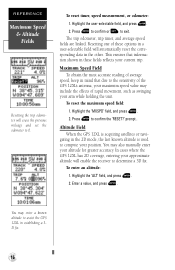
... to 0. REFERENCE Maximum Speed & Altitude Fields Resetting the trip odometer will erase the previous mileage and set the odometer to assist the GPS 12XL in establishing a 3D fix. 16 Press E to confirm or Q to the sensitivity of average speed, keep in the 2D mode,...odometer, trip timer, and average speed fields are linked. To reset the maximum speed field: 1. Altitude Field When the GPS 12XL is used to compute your approximate altitude will enable the receiver to confirm the 'RESET?' Highlight the user-selectable field, and press E. 2. Highlight the 'ALT' field, and press ...
... to 0. REFERENCE Maximum Speed & Altitude Fields Resetting the trip odometer will erase the previous mileage and set the odometer to assist the GPS 12XL in establishing a 3D fix. 16 Press E to confirm or Q to the sensitivity of average speed, keep in the 2D mode,...odometer, trip timer, and average speed fields are linked. To reset the maximum speed field: 1. Altitude Field When the GPS 12XL is used to compute your approximate altitude will enable the receiver to confirm the 'RESET?' Highlight the user-selectable field, and press E. 2. Highlight the 'ALT' field, and press ...

