Owner's Manual
Page 3
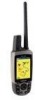
... information for Points of Interest (POIs) and other useful items. • Unlock optional maps. • Access MotionBased® Web-based activity tracker where you can view your saved tracks. • Download geocaches to move backward through your steps. • To extend battery life of the display... backlight (page 4). • To extend the DC 30 battery life, turn the unit off when you are not using your Astro 220. at www.my.garmin.com. Product Registration ...
... information for Points of Interest (POIs) and other useful items. • Unlock optional maps. • Access MotionBased® Web-based activity tracker where you can view your saved tracks. • Download geocaches to move backward through your steps. • To extend battery life of the display... backlight (page 4). • To extend the DC 30 battery life, turn the unit off when you are not using your Astro 220. at www.my.garmin.com. Product Registration ...

Owner's Manual
Page 27
...page. 3. OR If the city you want is found, the Astro 220 marks the cache as found, logs an entry into the calendar,...download geocache locations from the list. 2. Press MENU > MENU > Advanced > Find > Cities. Select a city from the Internet. A list of exits near your current location appears. 2. The exit description, a list of items near the exit, and the distance and bearing from the list > ENTER for details and how to my.garmin... of services near the new map location. To find a geocache: 1. Use the Rocker to move the map pointer to the map location you want , and ...
...page. 3. OR If the city you want is found, the Astro 220 marks the cache as found, logs an entry into the calendar,...download geocache locations from the list. 2. Press MENU > MENU > Advanced > Find > Cities. Select a city from the Internet. A list of exits near your current location appears. 2. The exit description, a list of items near the exit, and the distance and bearing from the list > ENTER for details and how to my.garmin... of services near the new map location. To find a geocache: 1. Use the Rocker to move the map pointer to the map location you want , and ...
Owner's Manual
Page 54
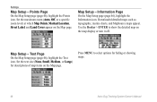
... Text icon. Press MENU to show the detailed map on the map display or turn it off. Map Setup - Information Page On the Map Setup page (page 46), highlight the Information icon. Downloaded detailed maps such as topographic, marine charts, and MapSource maps appear. Use the Rocker > ENTER to select ... icon. Settings Map Setup - Set the maximum zoom (Auto, Off, or a specific zoom level) at which Map Points, Marked Location, Street Label, and Land Cover appear on the Map page. Set the text size (None, Small, Medium, or Large) for hiding or showing maps. 48 Astro Dog Tracking System...
... Text icon. Press MENU to show the detailed map on the map display or turn it off. Map Setup - Information Page On the Map Setup page (page 46), highlight the Information icon. Downloaded detailed maps such as topographic, marine charts, and MapSource maps appear. Use the Rocker > ENTER to select ... icon. Settings Map Setup - Set the maximum zoom (Auto, Off, or a specific zoom level) at which Map Points, Marked Location, Street Label, and Land Cover appear on the Map page. Set the text size (None, Small, Medium, or Large) for hiding or showing maps. 48 Astro Dog Tracking System...
Owner's Manual
Page 55
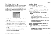
...for marine colors, spot soundings, light sectors, and symbol sets when using downloaded marine charts (MapSource BlueChart marine mapping data). • Marine Colors-turns marine colors On or Off on the Map page. • Spot Soundings-turns spot soundings that overlays the roads on ... Light Sectors-turns navigational light locations Off, Auto (location shown when map pointer passes over), or On. • Symbol Set-selects the map symbol set (Auto, GARMIN, NOAA, International). To select the guidance method your Astro 220 uses to calculate road routes: On the Routing Setup page, select ...
...for marine colors, spot soundings, light sectors, and symbol sets when using downloaded marine charts (MapSource BlueChart marine mapping data). • Marine Colors-turns marine colors On or Off on the Map page. • Spot Soundings-turns spot soundings that overlays the roads on ... Light Sectors-turns navigational light locations Off, Auto (location shown when map pointer passes over), or On. • Symbol Set-selects the map symbol set (Auto, GARMIN, NOAA, International). To select the guidance method your Astro 220 uses to calculate road routes: On the Routing Setup page, select ...
Owner's Manual
Page 64
... a new Removable Disk Drive listed. Select Edit > Paste. Install Garmin MapSource Trip and Waypoint Manager. Highlight the file, and select Edit > Copy. 3. Unplug your Astro 220 from Windows Explorer, click Tools > Map Network Drive and remap a drive letter for the microSD on Updates & Downloads. 58 Astro Dog Tracking System Owner's Manual Go to view the directory...
... a new Removable Disk Drive listed. Select Edit > Paste. Install Garmin MapSource Trip and Waypoint Manager. Highlight the file, and select Edit > Copy. 3. Unplug your Astro 220 from Windows Explorer, click Tools > Map Network Drive and remap a drive letter for the microSD on Updates & Downloads. 58 Astro Dog Tracking System Owner's Manual Go to view the directory...


