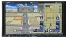
Owner's Manual
Page 2
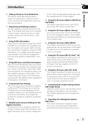
... Navigation Menu Screens 26 - Changing the scale of the map display between day and night 10 License Agreement 11 - Contents ! How to Use the Map 38 - Color difference of the map 43 for the Map Database 18 - About Gracenote® 19 Before Using the System Important Safety Information 21 Additional Safety Information 22 - Introduction Manual Overview 8 - PIONEER AVIC-Z3...
... Navigation Menu Screens 26 - Changing the scale of the map display between day and night 10 License Agreement 11 - Contents ! How to Use the Map 38 - Color difference of the map 43 for the Map Database 18 - About Gracenote® 19 Before Using the System Important Safety Information 21 Additional Safety Information 22 - Introduction Manual Overview 8 - PIONEER AVIC-Z3...
Owner's Manual
Page 3
Searching for Points of Navigation Interruption Screen 50 Changing the Map Color 50 Setting a Route to Your Destination Searching for POIs by specifying a city name first 53 Finding a POI in "Address Book" 60 - Deleting a POI ...entry in "Destination History" 64 Using Traffic Information Using XM NavTraffic Information 65 - Confirming traffic information on the Map 49 Viewing the Map Color Legend 49 Changing the View Mode for the Navigation Map 49 Setting the Map Color Change between Day and Night 50 Changing the Setting of Interest (POI) Statewide 51 - Registering a ...
Searching for Points of Navigation Interruption Screen 50 Changing the Map Color 50 Setting a Route to Your Destination Searching for POIs by specifying a city name first 53 Finding a POI in "Address Book" 60 - Deleting a POI ...entry in "Destination History" 64 Using Traffic Information Using XM NavTraffic Information 65 - Confirming traffic information on the Map 49 Viewing the Map Color Legend 49 Changing the View Mode for the Navigation Map 49 Setting the Map Color Change between Day and Night 50 Changing the Setting of Interest (POI) Statewide 51 - Registering a ...
Owner's Manual
Page 8
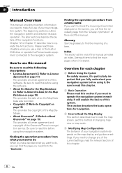
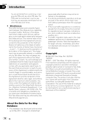
How to use a disc in the built-in DVD drive or operate the Pioneer audio equipment connected to the navigation system. Glossary See the glossary to find the main pages where it . The beginning sections outline the navigation system and describe its basic operation. Chapter 12 to Chapter 17...the "Contents". The later sections describe the details of the navigation functions. Be sure to read the map screen, and the method of changing map view or map scale. 5 Modifying Map Configurations The behavior of your new navigation system. Index The section at the end of the manual. ...
How to use a disc in the built-in DVD drive or operate the Pioneer audio equipment connected to the navigation system. Glossary See the glossary to find the main pages where it . The beginning sections outline the navigation system and describe its basic operation. Chapter 12 to Chapter 17...the "Contents". The later sections describe the details of the navigation functions. Be sure to read the map screen, and the method of changing map view or map scale. 5 Modifying Map Configurations The behavior of your new navigation system. Index The section at the end of the manual. ...
Owner's Manual
Page 9
...that can be used when Pioneer audio equipment featuring IP-BUS (MultiCD player, Interface adapter for iPod, TV tuner) is connected. If you need to hands-free phoning. The navigation system can record a music CD to the hard disk drive in the navigation system. This chapter describes ways...edit the points on the map and operation related traffic information. 9 Using XM Tuner and Other Information When Pioneer XM satellite radio tuner (GEXP10XMT) is connected to the navigation system, variety of information other location, and how to edit the entry in DVD Drive and Radio) This...
...that can be used when Pioneer audio equipment featuring IP-BUS (MultiCD player, Interface adapter for iPod, TV tuner) is connected. If you need to hands-free phoning. The navigation system can record a music CD to the hard disk drive in the navigation system. This chapter describes ways...edit the points on the map and operation related traffic information. 9 Using XM Tuner and Other Information When Pioneer XM satellite radio tuner (GEXP10XMT) is connected to the navigation system, variety of information other location, and how to edit the entry in DVD Drive and Radio) This...

Owner's Manual
Page 10
... this time are described in ALL CAPITAL, BOLD lettering: e.g.) MENU button, MAP button. ! tem are grayed out. ! Items in this : e.g.) = For details, refer to Modifying the Route Calculation Conditions on your navigation system and information such as a TV tuner or general-purpose AV equipment. Extra ...the screen are not avail- Please see may differ from the equipment that is connected to this system with this : e.g.) p Touch panel keys which are described in DVD drive or from those shown. About the definition of after-care. Chapter 01 Introduction j Appendix ...
... this time are described in ALL CAPITAL, BOLD lettering: e.g.) MENU button, MAP button. ! tem are grayed out. ! Items in this : e.g.) = For details, refer to Modifying the Route Calculation Conditions on your navigation system and information such as a TV tuner or general-purpose AV equipment. Extra ...the screen are not avail- Please see may differ from the equipment that is connected to this system with this : e.g.) p Touch panel keys which are described in DVD drive or from those shown. About the definition of after-care. Chapter 01 Introduction j Appendix ...

Owner's Manual
Page 15
.... BY USING YOUR COPY OF THE TELE ATLAS DATA, YOU AGREE TO THE TERMS AND CONDITIONS OF THIS AGREEMENT. 1 Grant of other use the map data and business points of interest information (the "POIs"), (together, the "Data") contained on the Data. No change this Agreement shall be governed by...by renting, leasing, publishing, leasing, sublicensing or transferring the Data to change in any other persons or entities. The Data is the entire Agreement between Pioneer and you agree to hold the Data in confidence and in trust and not to disclose the Data or any portions in this Agreement...
.... BY USING YOUR COPY OF THE TELE ATLAS DATA, YOU AGREE TO THE TERMS AND CONDITIONS OF THIS AGREEMENT. 1 Grant of other use the map data and business points of interest information (the "POIs"), (together, the "Data") contained on the Data. No change this Agreement shall be governed by...by renting, leasing, publishing, leasing, sublicensing or transferring the Data to change in any other persons or entities. The Data is the entire Agreement between Pioneer and you agree to hold the Data in confidence and in trust and not to disclose the Data or any portions in this Agreement...
Owner's Manual
Page 18
... 2001 - 2007 Tele Atlas. Tele Atlas is an authorized distributor of Santa Clara. Changes to standard sized passenger vehicles. Nothing in the map database applies only to streets/high- 18 En This Agreement may be held liable for the County of selected Statistics Canada computer files under ...determined to be invalid, illegal, or unenforceable, such provision or part thereof shall be stricken from this Agreement and the remainder of this map in the database. You may be delivered by Tele Atlas directly against you herein are not included in any applicable export laws. If...
... 2001 - 2007 Tele Atlas. Tele Atlas is an authorized distributor of Santa Clara. Changes to standard sized passenger vehicles. Nothing in the map database applies only to streets/high- 18 En This Agreement may be held liable for the County of selected Statistics Canada computer files under ...determined to be invalid, illegal, or unenforceable, such provision or part thereof shall be stricken from this Agreement and the remainder of this map in the database. You may be delivered by Tele Atlas directly against you herein are not included in any applicable export laws. If...
Owner's Manual
Page 26
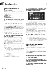
...], [Map], and [Settings]. If the route is turned off. Do not use audio source", refer to Using the AV Source (Built-in DVD Drive and Radio) on page 97 5 Turn off . The navigation menu is displayed. Displaying the Navigation menu 1 Press MENU button. 2 To change the language or time. (The settings can operate the navigation system...
...], [Map], and [Settings]. If the route is turned off. Do not use audio source", refer to Using the AV Source (Built-in DVD Drive and Radio) on page 97 5 Turn off . The navigation menu is displayed. Displaying the Navigation menu 1 Press MENU button. 2 To change the language or time. (The settings can operate the navigation system...

Owner's Manual
Page 27
...[Set My Favorites], and [My Favorites] can use En 27 Active subscription to XM NavTraffic is required to receive traffic information on the navigation system. = For details, refer to Using XM NavTraffic Information on page 65 = For details, refer to Emergency Info on the next page ... card transfer via Bluetooth technology. [Map] menu You can change [View Mode], or set route from this menu. = For more details about "Specifying the address and searching for emergencies. Use for cities where information is connected to the navigation system. GEX-P10XMT*1: XM Digital Satellite Data...
...[Set My Favorites], and [My Favorites] can use En 27 Active subscription to XM NavTraffic is required to receive traffic information on the navigation system. = For details, refer to Using XM NavTraffic Information on page 65 = For details, refer to Emergency Info on the next page ... card transfer via Bluetooth technology. [Map] menu You can change [View Mode], or set route from this menu. = For more details about "Specifying the address and searching for emergencies. Use for cities where information is connected to the navigation system. GEX-P10XMT*1: XM Digital Satellite Data...

Owner's Manual
Page 28
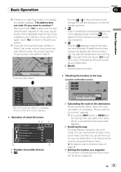
...Select the method for your surroundings appears. 8 After releasing the parking brake, drive in accordance with the navigation information, subject to your destination, and the map of searching for searching the destination. 3 Select the method of your destination. 28 En Calculating your vehicle...enable these functions, you cannot use [Address Search] and the basics of a specific button or function is indicated by using the navigation system. 1 Press MENU button to To ensure safe driving on page 22. Chapter 03 Basic Operation The availability of using Address Search The...
...Select the method for your surroundings appears. 8 After releasing the parking brake, drive in accordance with the navigation information, subject to your destination, and the map of searching for searching the destination. 3 Select the method of your destination. 28 En Calculating your vehicle...enable these functions, you cannot use [Address Search] and the basics of a specific button or function is indicated by using the navigation system. 1 Press MENU button to To ensure safe driving on page 22. Chapter 03 Basic Operation The availability of using Address Search The...

Owner's Manual
Page 30
... in 4. Chapter 03 Basic Operation Jump to the state selection screen. (Selected state code is shown. = For details, refer to Checking the location on the map on the next page 30 En a [Street]: Touch if you want to specify the destination city or area first. (This is available only when 4 is...
... in 4. Chapter 03 Basic Operation Jump to the state selection screen. (Selected state code is shown. = For details, refer to Checking the location on the map on the next page 30 En a [Street]: Touch if you want to specify the destination city or area first. (This is available only when 4 is...
Owner's Manual
Page 31
... be displayed within the displayed area, touching to the right of the item allows you to see remaining characters. 4: Touching displays a map of the place you have selected. (Possibilities for place names may not be set the location as your destination. 5 [Back]: Returns... location indicated by the scroll cursor as a waypoint. When the route calculation is no matching location, the navigation system displays "The address does not exist. Do you press MAP button or MENU button during route calculation, the calculation is completed, "Route confirmation screen" appears. # Operation...
... be displayed within the displayed area, touching to the right of the item allows you to see remaining characters. 4: Touching displays a map of the place you have selected. (Possibilities for place names may not be set the location as your destination. 5 [Back]: Returns... location indicated by the scroll cursor as a waypoint. When the route calculation is no matching location, the navigation system displays "The address does not exist. Do you press MAP button or MENU button during route calculation, the calculation is completed, "Route confirmation screen" appears. # Operation...

Owner's Manual
Page 33
Your navigation system gives you return to the route, the screen re- Direction of the freeway - Road number of travel - gine and get back on the hard disk drive, the screen changes to [Map Mode]. When you the fol- Distance to the original view and resumes route ...- turns to the next turning point - When you stop at a gas station or a restaurant during the route guidance, your navigation system remembers your surroundings reappears. lowing information with the timing adjusted to the speed of your destination and route information. Arrival of your ...
Your navigation system gives you return to the route, the screen re- Direction of the freeway - Road number of travel - gine and get back on the hard disk drive, the screen changes to [Map Mode]. When you the fol- Distance to the original view and resumes route ...- turns to the next turning point - When you stop at a gas station or a restaurant during the route guidance, your navigation system remembers your surroundings reappears. lowing information with the timing adjusted to the speed of your destination and route information. Arrival of your ...

Owner's Manual
Page 35
... the Current Route You can select two methods: ! Checking the passing streets with a list You can return to set correctly, the navigation system cannot consider traffic regulations correctly. p [Route Overview] is displayed only when the route is not available if your destination. En 35 Scroll...the current travel history taken into account. You can check the route details. Names of your route to Setting the time difference on the map Checking the passing streets with a list ! cludes freeway even if [On] is selected. Set the time difference correctly (= Refer to ...
... the Current Route You can select two methods: ! Checking the passing streets with a list You can return to set correctly, the navigation system cannot consider traffic regulations correctly. p [Route Overview] is displayed only when the route is not available if your destination. En 35 Scroll...the current travel history taken into account. You can check the route details. Names of your route to Setting the time difference on the map Checking the passing streets with a list ! cludes freeway even if [On] is selected. Set the time difference correctly (= Refer to ...

Owner's Manual
Page 36
view] is set waypoints in the route to your navigation system may not be shown in the list as you drive on.) Checking the ...light blue. 36 En The waypoint menu screen appears. 3 Touch [Add]. 3 Touch the screen and place the scroll cursor on a map, then touch [OK] to add to the waypoints. (You can view the detail or the entire picture. 4 Touch [Back]. "Route...and you set . 2 Touch [Detail]. p [Route Overview] is displayed only when the route is selected on the map You can also check the overview by using the shortcut menu if [Whole Route Over- Chapter 03 Basic Operation p When...
view] is set waypoints in the route to your navigation system may not be shown in the list as you drive on.) Checking the ...light blue. 36 En The waypoint menu screen appears. 3 Touch [Add]. 3 Touch the screen and place the scroll cursor on a map, then touch [OK] to add to the waypoints. (You can view the detail or the entire picture. 4 Touch [Back]. "Route...and you set . 2 Touch [Detail]. p [Route Overview] is displayed only when the route is selected on the map You can also check the overview by using the shortcut menu if [Whole Route Over- Chapter 03 Basic Operation p When...

Owner's Manual
Page 38
... ! How to view the map of the current location p This example shows a case where [Second Maneuver Arrow] is set to [View]. Rear View (Only possible when [Camera Input] is set to [On].) 1 Press MAP button to display a map of the area around your navigation system can display the view mode ...screen by your current position. 2 Press MAP button again. 3 Touch the mode name to select the mode you will travel along next...
... ! How to view the map of the current location p This example shows a case where [Second Maneuver Arrow] is set to [View]. Rear View (Only possible when [Camera Input] is set to [On].) 1 Press MAP button to display a map of the area around your navigation system can display the view mode ...screen by your current position. 2 Press MAP button again. 3 Touch the mode name to select the mode you will travel along next...

Owner's Manual
Page 39
... 3D POI Depending on the data, the POI may show a different speed than your vehicle's actual speedometer, because your vehicle. How to Read the Map Display Chapter 04 How to 3D Landmark on page 47 Vehicle Dynamics Display Indicates the status of your unit measures speed in a different way. 8 4... Dynamics Display mode, the speedometer display may appear in graphical 3D or plate format with the setting of [Overlay POI]. 2D Twin Map View You can display a map in half. The right screen and the left and right meters. = For details, refer to Setting the Vehicle Dynamics Display on ...
... 3D POI Depending on the data, the POI may show a different speed than your vehicle's actual speedometer, because your vehicle. How to Read the Map Display Chapter 04 How to 3D Landmark on page 47 Vehicle Dynamics Display Indicates the status of your unit measures speed in a different way. 8 4... Dynamics Display mode, the speedometer display may appear in graphical 3D or plate format with the setting of [Overlay POI]. 2D Twin Map View You can display a map in half. The right screen and the left and right meters. = For details, refer to Setting the Vehicle Dynamics Display on ...

Owner's Manual
Page 40
..., indicating the recommended lane to be in to easily maneuver the next guidance. when monitoring an attached trailer) as a split screen where map information is not resized to fit to screen, and that a portion of camera image may not be viewable. Please beware that case, ...whether the camera's functions or lifetime would be affected. In that in this setting, camera image is partially displayed. Enlarged map of the intersection (2D) d e n Enlarged map of the intersection (3D) Display during freeway driving In certain locations of the freeway, lane information is not displayed. ...
..., indicating the recommended lane to be in to easily maneuver the next guidance. when monitoring an attached trailer) as a split screen where map information is not resized to fit to screen, and that a portion of camera image may not be viewable. Please beware that case, ...whether the camera's functions or lifetime would be affected. In that in this setting, camera image is partially displayed. Enlarged map of the intersection (2D) d e n Enlarged map of the intersection (3D) Display during freeway driving In certain locations of the freeway, lane information is not displayed. ...

Owner's Manual
Page 41
...The head of interchanges and exits. dance point)* 2 Distance to the guidance point* Touching allows you drive. How to Read the Map Display Chapter 04 How to Read the Map Display While driving on the freeway, freeway exit numbers and freeway signs may be displayed when in the vicinity of the triangular...used (or next gui- If waypoints are dis- p When the vehicle position is on this button shows the dis- tance to "North up : The map display always shows the vehi- If the scale is fixed to the destination (or waypoint) appears. 4 Street name (or city name) that it is ...
...The head of interchanges and exits. dance point)* 2 Distance to the guidance point* Touching allows you drive. How to Read the Map Display Chapter 04 How to Read the Map Display While driving on the freeway, freeway exit numbers and freeway signs may be displayed when in the vicinity of the triangular...used (or next gui- If waypoints are dis- p When the vehicle position is on this button shows the dis- tance to "North up : The map display always shows the vehi- If the scale is fixed to the destination (or waypoint) appears. 4 Street name (or city name) that it is ...

Owner's Manual
Page 42
...k Bluetooth Connected icon This icon shows whether the cellular phone featuring Bluetooth technology is an ideal value calculated based on the enlarged intersection map. Chapter 04 How to Chapter 18 9 Traffic status This appears when an XM satellite radio tuner (GEX-P10XMT, sold separately) is ...connected. = For details, refer to Read the Map Display ! ANTENNA - UPDATING - p The estimated time of arrival (or travel * When you approach a interchange, junction, or exit, the lane ...
...k Bluetooth Connected icon This icon shows whether the cellular phone featuring Bluetooth technology is an ideal value calculated based on the enlarged intersection map. Chapter 04 How to Chapter 18 9 Traffic status This appears when an XM satellite radio tuner (GEX-P10XMT, sold separately) is ...connected. = For details, refer to Read the Map Display ! ANTENNA - UPDATING - p The estimated time of arrival (or travel * When you approach a interchange, junction, or exit, the lane ...


