Owner's Manual
Page 21
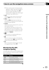
Indicator : : : : Meaning GPS navigation possible Insufficient GPS navigation GPS navigation not possible No connection to GPS receiver Chapter 04 En 21 How to use the navigation menu screens p When entering text, the first character appears in lower case. Touching and... to a Greek keyboard. 5 Results Touch to finalize the keyboard entry (open the list of the position information. Monitoring the GPS reception quality In the top right corner, the GPS reception quality icon shows the current accuracy of results before it appears automatically, touch [Results]). 6 Touch to switch to a ...
Indicator : : : : Meaning GPS navigation possible Insufficient GPS navigation GPS navigation not possible No connection to GPS receiver Chapter 04 En 21 How to use the navigation menu screens p When entering text, the first character appears in lower case. Touching and... to a Greek keyboard. 5 Results Touch to finalize the keyboard entry (open the list of the position information. Monitoring the GPS reception quality In the top right corner, the GPS reception quality icon shows the current accuracy of results before it appears automatically, touch [Results]). 6 Touch to switch to a ...
Owner's Manual
Page 24
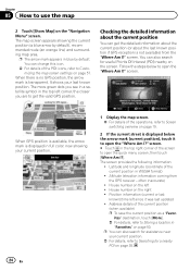
...the current position in blue by default), recommended route (an orange line) and surrounding map area. You can get the valid GPS position. Position information (current or last known)/time left ! Chapter 05 How to Customizing the map screen settings on page 57....default. p The arrow mark appears in WGS84 format) ! When there is no GPS position, the arrow mark is not available) from the GPS receiver - Checking the detailed information about the last known position if GPS reception is transparent. screen. The screen provides the following information: ! Altitude (elevation...
...the current position in blue by default), recommended route (an orange line) and surrounding map area. You can get the valid GPS position. Position information (current or last known)/time left ! Chapter 05 How to Customizing the map screen settings on page 57....default. p The arrow mark appears in WGS84 format) ! When there is no GPS position, the arrow mark is not available) from the GPS receiver - Checking the detailed information about the last known position if GPS reception is transparent. screen. The screen provides the following information: ! Altitude (elevation...
Owner's Manual
Page 46
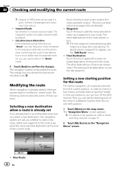
... "Navigation Menu" screen appears. = For details of the route remain intact. p The new waypoint is now the last waypoint. Then you can turn off the GPS receiver. The navigation system recalculates the route. Unpaved Roads: Set whether to confirm the changes. If this key to plan a new route to modify the current...
... "Navigation Menu" screen appears. = For details of the route remain intact. p The new waypoint is now the last waypoint. Then you can turn off the GPS receiver. The navigation system recalculates the route. Unpaved Roads: Set whether to confirm the changes. If this key to plan a new route to modify the current...

Owner's Manual
Page 56
.... ! Cancel Route: Cancels the route and stops navigation. Itinerary: Displays the list of the selected vehicle profile. ! GPS Info: Displays the GPS information screen with the next one of Interest in route calculation. Historical Traffic: You can search for example on public holidays...(Detour, and Event types) are all related to enable or disable historical traffic data and traffic patterns by touching this system uses the received real-time traffic information in various different ways. ! Where Am I?: Displays a special screen with a previously saved route. ! Setting ...
.... ! Cancel Route: Cancels the route and stops navigation. Itinerary: Displays the list of the selected vehicle profile. ! GPS Info: Displays the GPS information screen with the next one of Interest in route calculation. Historical Traffic: You can search for example on public holidays...(Detour, and Event types) are all related to enable or disable historical traffic data and traffic patterns by touching this system uses the received real-time traffic information in various different ways. ! Where Am I?: Displays a special screen with a previously saved route. ! Setting ...
Owner's Manual
Page 60
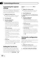
... later be used to be displayed on page 54. 2 Touch [Regional]. 3 Touch the setting item. ! They can set other country specific units used by the GPS receiver, can turn on the automatic saving here. You can let this system. !
... later be used to be displayed on page 54. 2 Touch [Regional]. 3 Touch the setting item. ! They can set other country specific units used by the GPS receiver, can turn on the automatic saving here. You can let this system. !

Owner's Manual
Page 66
...(supplied). Yellow (B+) To the terminal that the power is always supplied regardless of your Pioneer AV receiver. AV receiver RGB cable (supplied) 2 m (6 ft. 7 in.) TMC antenna (supplied) 2.65 m (8 ft. 8 in.) Attach the GPS antenna to the "GPS ANTENNA" jack on the back of the ignition switch position. 66 En Fuse (3 A,... Power cord (supplied) Black (GND) To vehicle (metal) body. GPS antenna (supplied) Affix the double-sided tape (supplied) on the double-sided tape. Connect the other end of the cable to the AV receiver using an 11 mm (.4 in ) screw Where applicable, secure the ...
...(supplied). Yellow (B+) To the terminal that the power is always supplied regardless of your Pioneer AV receiver. AV receiver RGB cable (supplied) 2 m (6 ft. 7 in.) TMC antenna (supplied) 2.65 m (8 ft. 8 in.) Attach the GPS antenna to the "GPS ANTENNA" jack on the back of the ignition switch position. 66 En Fuse (3 A,... Power cord (supplied) Black (GND) To vehicle (metal) body. GPS antenna (supplied) Affix the double-sided tape (supplied) on the double-sided tape. Connect the other end of the cable to the AV receiver using an 11 mm (.4 in ) screw Where applicable, secure the ...
Owner's Manual
Page 68
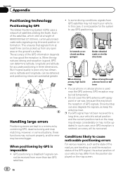
... two dimensions, latitude and longitude, can be obtained and positioning errors are traveling on and the reception status of the GPS signal, the actual position of GPS signals. p If a GPS signal has not been received for accurate positioning in some driving conditions, signals from any open area on the ground's surface. In this may...
... two dimensions, latitude and longitude, can be obtained and positioning errors are traveling on and the reception status of the GPS signal, the actual position of GPS signals. p If a GPS signal has not been received for accurate positioning in some driving conditions, signals from any open area on the ground's surface. In this may...
Owner's Manual
Page 74
... voltage range: 12.0 V to improvements. 74 En channel system Reception frequency 1 575.42 MHz Sensitivity 157.5 dBm (typ) Position update frequency Approx. once per second GPS antenna Antenna Micro strip flat antenna/ right-handed helical polarization Antenna cable 3.0 m (9.84 ft.) Dimensions (W × H × D) ... 50.6 mm × 15.5 mm &#...consumption 0.21 A Dimensions (W × H × D): 134 mm × 29 mm × 84 mm (5-1/4 in. × 1-1/8 in. × 3-1/4 in.) Weight 140 g (0.31 lbs) GPS receiver System L1, C/Acode GPS Reception system 32 tracking/32 acquisition-
... voltage range: 12.0 V to improvements. 74 En channel system Reception frequency 1 575.42 MHz Sensitivity 157.5 dBm (typ) Position update frequency Approx. once per second GPS antenna Antenna Micro strip flat antenna/ right-handed helical polarization Antenna cable 3.0 m (9.84 ft.) Dimensions (W × H × D) ... 50.6 mm × 15.5 mm &#...consumption 0.21 A Dimensions (W × H × D): 134 mm × 29 mm × 84 mm (5-1/4 in. × 1-1/8 in. × 3-1/4 in.) Weight 140 g (0.31 lbs) GPS receiver System L1, C/Acode GPS Reception system 32 tracking/32 acquisition-


