Owner's Manual
Page 2
... Pioneer product. for Points of a street 30 Searching for a location by entering the city center 30 Finding the location by specifying the ZIP code 31 Searching for Canada 8 - Traffic information 14 - route settings screen) 20 Operating the on-screen keyboard 20 Monitoring the GPS ... and selecting a location Searching for a location by address 29 Searching for a location by entering the midpoint of Interest (POI) 32 - PIONEER AVIC-U250 - Please read the map screen 22 Frequently shown route events 23 Seeing the current position on each menu 20 Operating list screens (e.g. for ...
... Pioneer product. for Points of a street 30 Searching for a location by entering the city center 30 Finding the location by specifying the ZIP code 31 Searching for Canada 8 - Traffic information 14 - route settings screen) 20 Operating the on-screen keyboard 20 Monitoring the GPS ... and selecting a location Searching for a location by address 29 Searching for a location by entering the midpoint of Interest (POI) 32 - PIONEER AVIC-U250 - Please read the map screen 22 Frequently shown route events 23 Seeing the current position on each menu 20 Operating list screens (e.g. for ...

Owner's Manual
Page 4
When positioning by GPS 68 Handling large errors 68 - Route search specifications 70 SD and SDHC logo 71 Display information 72 Glossary 73 Specifications 74 4 En Conditions likely to cause noticeable positioning errors 68 Route setting information 70 - Contents Before installing this product 64 To prevent damage 64 Precautions before installation 65 Connecting the system 66 Installing with the hook and loop fastener 67 Appendix Positioning technology 68 - Positioning by GPS is impossible 68 -
When positioning by GPS 68 Handling large errors 68 - Route search specifications 70 SD and SDHC logo 71 Display information 72 Glossary 73 Specifications 74 4 En Conditions likely to cause noticeable positioning errors 68 Route setting information 70 - Contents Before installing this product 64 To prevent damage 64 Precautions before installation 65 Connecting the system 66 Installing with the hook and loop fastener 67 Appendix Positioning technology 68 - Positioning by GPS is impossible 68 -
Owner's Manual
Page 21
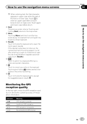
...offering numeric and symbol characters. 7 Touch to correct your entry on Caps Lock. Indicator : : : : Meaning GPS navigation possible Insufficient GPS navigation GPS navigation not possible No connection to GPS receiver Chapter 04 En 21 How to use the navigation menu screens p When entering text, the first character appears ... input string. 8 Touch to finalize the keyboard entry (accept the suggested search result). Monitoring the GPS reception quality In the top right corner, the GPS reception quality icon shows the current accuracy of the text is in upper case while the rest of...
...offering numeric and symbol characters. 7 Touch to correct your entry on Caps Lock. Indicator : : : : Meaning GPS navigation possible Insufficient GPS navigation GPS navigation not possible No connection to GPS receiver Chapter 04 En 21 How to use the navigation menu screens p When entering text, the first character appears ... input string. 8 Touch to finalize the keyboard entry (accept the suggested search result). Monitoring the GPS reception quality In the top right corner, the GPS reception quality icon shows the current accuracy of the text is in upper case while the rest of...
Owner's Manual
Page 24
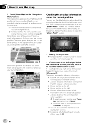
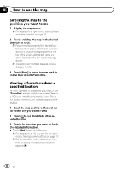
... position as a "Favor- The more green dots you are to open the "Where Am I ?" When GPS position is available, the arrow mark is not available) from the GPS receiver - Position information (current or last known)/time left ! Checking the detailed information about the last known ...the current position (or about the current position You can also search for a nearby POI on the right ! p You can get the valid GPS position. ites" destination, touch [More]. = For details, refer to Searching for assistance near your current position. = For details, refer to Storing...
... position as a "Favor- The more green dots you are to open the "Where Am I ?" When GPS position is available, the arrow mark is not available) from the GPS receiver - Position information (current or last known)/time left ! Checking the detailed information about the last known ...the current position (or about the current position You can also search for a nearby POI on the right ! p You can get the valid GPS position. ites" destination, touch [More]. = For details, refer to Searching for assistance near your current position. = For details, refer to Storing...
Owner's Manual
Page 26
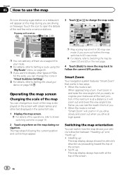
... or a restaurant will zoom in if you drive slowly and zoom out when you drive at high speed. Touch the icon to follow the current GPS position. Smart Zoom Your navigation system features "Smart Zoom" that works in 3D map view mode. Switching the map orientation You can change the map...
... or a restaurant will zoom in if you drive slowly and zoom out when you drive at high speed. Touch the icon to follow the current GPS position. Smart Zoom Your navigation system features "Smart Zoom" that works in 3D map view mode. Switching the map orientation You can change the map...
Owner's Manual
Page 27
... the map during navigation. p When the 3D map screen is selected, is displayed. 4 Touch [Back] to move the map back to follow the current GPS position. En 27 The map stops following the current position and control keys appear. 3 Touch to switch the map orientation. Each time you touch the... in large steps and touching and holding the key modifies it continuously and smoothly. 4 Touch [Back] to move the map back to follow the current GPS position. 3 Touch / to tilt up " when the 3D map screen is displayed. 1 Display the map screen. = For details of the operations, refer to Screen ...
... the map during navigation. p When the 3D map screen is selected, is displayed. 4 Touch [Back] to move the map back to follow the current GPS position. En 27 The map stops following the current position and control keys appear. 3 Touch to switch the map orientation. Each time you touch the... in large steps and touching and holding the key modifies it continuously and smoothly. 4 Touch [Back] to move the map back to follow the current GPS position. 3 Touch / to tilt up " when the 3D map screen is displayed. 1 Display the map screen. = For details of the operations, refer to Screen ...
Owner's Manual
Page 28
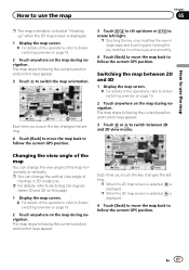
... direction to scroll. Place the cursor over the icon to view detailed information. 1 Scroll the map and move the map back to follow the current GPS position. p The scrolling increment depends on your dragging length. 3 Touch [Back] to move the scroll cursor to the icon you want to view. 2 Touch to...
... direction to scroll. Place the cursor over the icon to view detailed information. 1 Scroll the map and move the map back to follow the current GPS position. p The scrolling increment depends on your dragging length. 3 Touch [Back] to move the scroll cursor to the icon you want to view. 2 Touch to...
Owner's Manual
Page 33
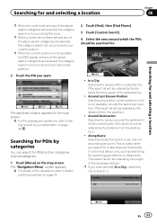
... a selected city. (The result list will occur around your last known position. 3 Touch the POI you want. p When the current position is not available (no GPS signal) and any of the above search categories are selected, the category search will be ordered by the distance from the center of the selected...
... a selected city. (The result list will occur around your last known position. 3 Touch the POI you want. p When the current position is not available (no GPS signal) and any of the above search categories are selected, the category search will be ordered by the distance from the center of the selected...
Owner's Manual
Page 40
... Menu" screen. If you want to set. Chapter 07 After the location is decided 5 Touch any of the alternatives to see it is the current GPS position, is displayed. 4 Touch .
... Menu" screen. If you want to set. Chapter 07 After the location is decided 5 Touch any of the alternatives to see it is the current GPS position, is displayed. 4 Touch .
Owner's Manual
Page 46
...! Unpaved Roads: Set whether to appear, use the "Edit Route" menu. ! Calculate Green Alternative: If the selected routing method is much better than the current GPS position. 1 Touch [Menu] on the map screen. tinations to check future routes, simulate them or see their length in the vehicle. ! Chapter 08 Checking and...time and distance, you can quickly switch to "Green" mode. 5 Touch [Back] to a different location than the selected method, you can turn off the GPS receiver. Setting a new starting point of those options. In order to keep the route optimal. New Route: 46 En
...! Unpaved Roads: Set whether to appear, use the "Edit Route" menu. ! Calculate Green Alternative: If the selected routing method is much better than the current GPS position. 1 Touch [Menu] on the map screen. tinations to check future routes, simulate them or see their length in the vehicle. ! Chapter 08 Checking and...time and distance, you can quickly switch to "Green" mode. 5 Touch [Back] to a different location than the selected method, you can turn off the GPS receiver. Setting a new starting point of those options. In order to keep the route optimal. New Route: 46 En
Owner's Manual
Page 47
...point of the route the same way as you already have a route. 7 Touch [Set Start]. If the current route already existed, it is no GPS reception). The "Navigation Menu" screen appears. = For details of destinations. En 47 Editing the list of destinations You can add or remove destinations, ...modify the start position or reorder the list. 1 Touch [Menu] on GPS]. Checking and modifying the current route 4 Touch on the first line (normally the current GPS position) and confirm your action on the warning message screen. # Touch [Turn on the map screen. ...
...point of the route the same way as you already have a route. 7 Touch [Set Start]. If the current route already existed, it is no GPS reception). The "Navigation Menu" screen appears. = For details of destinations. En 47 Editing the list of destinations You can add or remove destinations, ...modify the start position or reorder the list. 1 Touch [Menu] on GPS]. Checking and modifying the current route 4 Touch on the first line (normally the current GPS position) and confirm your action on the warning message screen. # Touch [Turn on the map screen. ...

Owner's Manual
Page 56
... you can select one if waypoints are available only if the receiver is enabled. ! The key is not always the same between two points. GPS Info: Displays the GPS information screen with a previously saved route. ! You can be better to turn off in route calculation. Remove Next Waypoint: Skips the next waypoint...
... you can select one if waypoints are available only if the receiver is enabled. ! The key is not always the same between two points. GPS Info: Displays the GPS information screen with a previously saved route. ! You can be better to turn off in route calculation. Remove Next Waypoint: Skips the next waypoint...
Owner's Manual
Page 60
... settings screen. = For details of the user interface. Starting the configuration wizard Modify the basic software parameters set other country specific units used by the GPS receiver, can let this . Program Language: This key displays the current written language of the operations, refer to Displaying the settings screen on the map...
... settings screen. = For details of the user interface. Starting the configuration wizard Modify the basic software parameters set other country specific units used by the GPS receiver, can let this . Program Language: This key displays the current written language of the operations, refer to Displaying the settings screen on the map...
Owner's Manual
Page 63
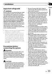
...away in considerable danger. ! Be sure to the risk of the steps in place for professional installation only. Do not cut the GPS antenna cable to shorten it or use an extension to remain exposed. ! Do not shorten any bare wiring to make adjustments while safely... parked. Installation Chapter 13 Installation Important safeguards WARNING Pioneer does not recommend that they will be exceeded, causing overheating. Precautions before installing your vehicle as a result of the lead will not...
...away in considerable danger. ! Be sure to the risk of the steps in place for professional installation only. Do not cut the GPS antenna cable to shorten it or use an extension to remain exposed. ! Do not shorten any bare wiring to make adjustments while safely... parked. Installation Chapter 13 Installation Important safeguards WARNING Pioneer does not recommend that they will be exceeded, causing overheating. Precautions before installing your vehicle as a result of the lead will not...

Owner's Manual
Page 66
... unit Power cord (supplied) Black (GND) To vehicle (metal) body. Yellow (B+) To the terminal that the power is always supplied regardless of your Pioneer AV receiver. Chapter 13 Installation Connecting the system Insert one end of the RGB cable into the "DATA BUS" slot on the side of this... back of the ignition switch position. 66 En AV receiver RGB cable (supplied) 2 m (6 ft. 7 in.) TMC antenna (supplied) 2.65 m (8 ft. 8 in.) Attach the GPS antenna to the AV receiver using an 11 mm (.4 in ) screw (supplied). TMC antenna IF 3 m (9 ft. 10 in.) Secure the RGB cable with an 11...
... unit Power cord (supplied) Black (GND) To vehicle (metal) body. Yellow (B+) To the terminal that the power is always supplied regardless of your Pioneer AV receiver. Chapter 13 Installation Connecting the system Insert one end of the RGB cable into the "DATA BUS" slot on the side of this... back of the ignition switch position. 66 En AV receiver RGB cable (supplied) 2 m (6 ft. 7 in.) TMC antenna (supplied) 2.65 m (8 ft. 8 in.) Attach the GPS antenna to the AV receiver using an 11 mm (.4 in ) screw (supplied). TMC antenna IF 3 m (9 ft. 10 in.) Secure the RGB cable with an 11...
Owner's Manual
Page 68
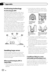
...reception of your vehicle. This ensures that signals from at a height of satellites orbiting the Earth. When positioning by GPS is used near the GPS antenna, GPS reception may not reach your vehicle may become bigger. In tunnels or enclosed parking garages Under elevated roads or similar ...is impossible ! Each of the satellites, which orbit at least three can determine latitude, longitude and altitude for the system to use GPS positioning. When the signals are traveling on how good the reception is restored, accuracy will be obtained and positioning errors are kept ...
...reception of your vehicle. This ensures that signals from at a height of satellites orbiting the Earth. When positioning by GPS is used near the GPS antenna, GPS reception may not reach your vehicle may become bigger. In tunnels or enclosed parking garages Under elevated roads or similar ...is impossible ! Each of the satellites, which orbit at least three can determine latitude, longitude and altitude for the system to use GPS positioning. When the signals are traveling on how good the reception is restored, accuracy will be obtained and positioning errors are kept ...
Owner's Manual
Page 70
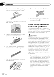
... is open during the morning only, but you arrive later, it would be able to the map data. If trees or other obstacles block the GPS signals for the route are automatically set the streets you drive around a large parking lot. ! One-way streets and street closures may not know some...
... is open during the morning only, but you arrive later, it would be able to the map data. If trees or other obstacles block the GPS signals for the route are automatically set the streets you drive around a large parking lot. ! One-way streets and street closures may not know some...
Owner's Manual
Page 73
... out by the system to check a route traveled or if returning along your destination. It is handy when you drive to a specific location; En 73 GPS Global Positioning System. The next guidance point along a complex route. RDS-TMC A communication system for a variety of the latest traffic information using FM multiplex broadcast...
... out by the system to check a route traveled or if returning along your destination. It is handy when you drive to a specific location; En 73 GPS Global Positioning System. The next guidance point along a complex route. RDS-TMC A communication system for a variety of the latest traffic information using FM multiplex broadcast...
Owner's Manual
Page 74
....) Dimensions (W × H × D) ... 50.6 mm × 15.5 mm × 50.6 mm (1.99 in. × 0.61 in. × 1.99 in .) Weight 140 g (0.31 lbs) GPS receiver System L1, C/Acode GPS Reception system 32 tracking/32 acquisition- channel system Reception frequency 1 575.42 MHz Sensitivity 157.5 dBm (typ) Position update frequency Approx. Appendix Appendix...
....) Dimensions (W × H × D) ... 50.6 mm × 15.5 mm × 50.6 mm (1.99 in. × 0.61 in. × 1.99 in .) Weight 140 g (0.31 lbs) GPS receiver System L1, C/Acode GPS Reception system 32 tracking/32 acquisition- channel system Reception frequency 1 575.42 MHz Sensitivity 157.5 dBm (typ) Position update frequency Approx. Appendix Appendix...


