Instruction Manual
Page 1
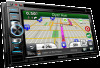
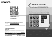
... KENWOOD Corporation 13DNX_IM366_Ref_K_En_01 (K/K2/R) 1 In this instruction manual. Check the latest edition What Do You Want To Do? With one-click, you can jump to the section of the media you want to read through this manual, you will help you call upon your new GPS Navigation System. DNX890HD DNX7700BT DNX690HD DNX570HD DNX5080EX DNX5700BT GPS NAVIGATION... service on the warranty card, and in the space provided below to the model and serial numbers whenever you obtain the best performance from your Kenwood dealer for purchasing the KENWOOD GPS NAVIGATION SYSTEM.
... KENWOOD Corporation 13DNX_IM366_Ref_K_En_01 (K/K2/R) 1 In this instruction manual. Check the latest edition What Do You Want To Do? With one-click, you can jump to the section of the media you want to read through this manual, you will help you call upon your new GPS Navigation System. DNX890HD DNX7700BT DNX690HD DNX570HD DNX5080EX DNX5700BT GPS NAVIGATION... service on the warranty card, and in the space provided below to the model and serial numbers whenever you obtain the best performance from your Kenwood dealer for purchasing the KENWOOD GPS NAVIGATION SYSTEM.
User Manual
Page 2
...User License Agreements 4 Getting Started 10 Using the Navigation System 10 Help When You Need It 10 Searching Help Topics 10 Status Bar Icons 10 Satellite Signals 11 Viewing GPS Satellite Signals 11 Using the On-Screen Buttons 11...Stopping the Route 18 Updating Speed Limits 18 Using Suggested Routes 18 Using Exit Services 18 Finding Exit Services 19 Navigating to an Exit 19 Using Find Ahead 19 Avoiding Road Features 19 Adding a Custom Avoidance Area 19 Avoiding ... Nearby Services 23 Directions to Your Current Location 23 2 GPS Navigation Instruction Manual
...User License Agreements 4 Getting Started 10 Using the Navigation System 10 Help When You Need It 10 Searching Help Topics 10 Status Bar Icons 10 Satellite Signals 11 Viewing GPS Satellite Signals 11 Using the On-Screen Buttons 11...Stopping the Route 18 Updating Speed Limits 18 Using Suggested Routes 18 Using Exit Services 18 Finding Exit Services 19 Navigating to an Exit 19 Using Find Ahead 19 Avoiding Road Features 19 Adding a Custom Avoidance Area 19 Avoiding ... Nearby Services 23 Directions to Your Current Location 23 2 GPS Navigation Instruction Manual
User Manual
Page 4
... restrictions set forth in the following terms and conditions which are capable of Garmin and/or its licensors (including their licensors and 4 GPS Navigation Instruction Manual suppliers) and affiliated companies on the other similar purposes. The third-party map data embedded in any other applications and data... America LLC and/or its subsidiaries ("Garmin"). Garmin Ltd. End-User License Agreements Software License Agreement BY USING THE DNX890HD / DNX690HD / DNX570HD / DNX5080EX, YOU AGREE TO BE BOUND BY THE TERMS AND CONDITIONS OF THE FOLLOWING SOFTWARE LICENSE AGREEMENT.
... restrictions set forth in the following terms and conditions which are capable of Garmin and/or its licensors (including their licensors and 4 GPS Navigation Instruction Manual suppliers) and affiliated companies on the other similar purposes. The third-party map data embedded in any other applications and data... America LLC and/or its subsidiaries ("Garmin"). Garmin Ltd. End-User License Agreements Software License Agreement BY USING THE DNX890HD / DNX690HD / DNX570HD / DNX5080EX, YOU AGREE TO BE BOUND BY THE TERMS AND CONDITIONS OF THE FOLLOWING SOFTWARE LICENSE AGREEMENT.
User Manual
Page 6
... Postal Service®. You agree to submit to the jurisdiction of the Netherlands for the International Sale of Goods, which is effective until such time 6 GPS Navigation Instruction Manual as (i) if applicable, your Product uses RDS-TMC Codes contained in the Map Data, the traffic location codes are inconsistent with, or conflict...
... Postal Service®. You agree to submit to the jurisdiction of the Netherlands for the International Sale of Goods, which is effective until such time 6 GPS Navigation Instruction Manual as (i) if applicable, your Product uses RDS-TMC Codes contained in the Map Data, the traffic location codes are inconsistent with, or conflict...
User Manual
Page 8
...traffic receiver (as long as you will operate properly as is shorter. If you purchase "lifetime" or "one-time" traffic, you own a compatible Garmin GPS) or as long as a result of weather difficulties, the destruction of transmitters and/or broadcasting infrastructures, a natural disaster, and/or a lack of reliability,... subsidiaries), and their suppliers make no representations about content, traffic and road conditions, route usability, or speed. You agree to the reliability, 8 GPS Navigation Instruction Manual accuracy, exhaustiveness, and completeness of your Garmin product.
...traffic receiver (as long as you will operate properly as is shorter. If you purchase "lifetime" or "one-time" traffic, you own a compatible Garmin GPS) or as long as a result of weather difficulties, the destruction of transmitters and/or broadcasting infrastructures, a natural disaster, and/or a lack of reliability,... subsidiaries), and their suppliers make no representations about content, traffic and road conditions, route usability, or speed. You agree to the reliability, 8 GPS Navigation Instruction Manual accuracy, exhaustiveness, and completeness of your Garmin product.
User Manual
Page 10
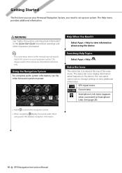
... information, see the other important information. ⁄ • The screenshots shown in this displays navigation information. Help When You Need It Select Apps > Help to access the navigation system. • When navigating, ➋ displays Kenwood audio. Status Bar Icons The status bar is located at the top of the main menu. ... WARNING See "Safety Precautions and Important Information" in the Quick Start Guide for reference only. When using the device. See (page 24). 10 GPS Navigation Instruction Manual GPS signal status. Searching Help Topics Select Apps > Help > .
... information, see the other important information. ⁄ • The screenshots shown in this displays navigation information. Help When You Need It Select Apps > Help to access the navigation system. • When navigating, ➋ displays Kenwood audio. Status Bar Icons The status bar is located at the top of the main menu. ... WARNING See "Safety Precautions and Important Information" in the Quick Start Guide for reference only. When using the device. See (page 24). 10 GPS Navigation Instruction Manual GPS signal status. Searching Help Topics Select Apps > Help > .
User Manual
Page 12
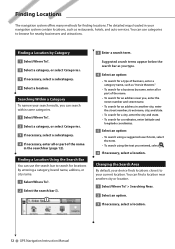
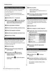
...necessary, enter all or part of the name in the search bar (page 12). Finding Locations The navigation system offers many methods for nearby businesses and attractions. Changing the Search Area By default, your device ...type of business, enter a category name, such as restaurants, hotels, and auto services. You can use categories to your navigation system contain locations, such as "movie theaters." • To search for locations by Category 1 Select Where To?. 2...> Searching Near. 2 Select an option. 3 If necessary, select a location. 12 GPS Navigation Instruction Manual
...necessary, enter all or part of the name in the search bar (page 12). Finding Locations The navigation system offers many methods for nearby businesses and attractions. Changing the Search Area By default, your device ...type of business, enter a category name, such as restaurants, hotels, and auto services. You can use categories to your navigation system contain locations, such as "movie theaters." • To search for locations by Category 1 Select Where To?. 2...> Searching Near. 2 Select an option. 3 If necessary, select a location. 12 GPS Navigation Instruction Manual
User Manual
Page 14
... of places. Find a Location Using Quick Search After you can find places included in the map data, such as "Home" in the Saved menu. 14 GPS Navigation Instruction Manual Finding a Location by Browsing the Map Before you have performed a search for places along the road (page 21). 1 Select View Map. 2 Drag and...
... of places. Find a Location Using Quick Search After you can find places included in the map data, such as "Home" in the Saved menu. 14 GPS Navigation Instruction Manual Finding a Location by Browsing the Map Before you have performed a search for places along the road (page 21). 1 Select View Map. 2 Drag and...
User Manual
Page 16
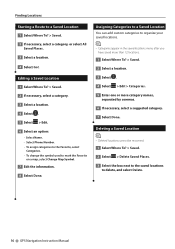
... To? > Saved. 2 If necessary, select a category, or select All Saved Places. 3 Select a location. 4 Select Go!. Finding Locations Starting a Route to delete, and select Delete. 16 GPS Navigation Instruction Manual Editing a Saved Location 1 Select Where To? > Saved. 2 If necessary, select a category. 3 Select a location. 4 Select . 5 Select > Edit. 6 Select an option: • Select Name. •...
... To? > Saved. 2 If necessary, select a category, or select All Saved Places. 3 Select a location. 4 Select Go!. Finding Locations Starting a Route to delete, and select Delete. 16 GPS Navigation Instruction Manual Editing a Saved Location 1 Select Where To? > Saved. 2 If necessary, select a category. 3 Select a location. 4 Select . 5 Select > Edit. 6 Select an option: • Select Name. •...
User Manual
Page 18
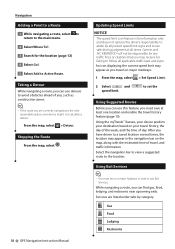
... Set Speed Limit. 2 Select and speed limit. From the map, select > Detour. Stopping the Route From the map, select . 18 GPS Navigation Instruction Manual Updating Speed Limits NOTICE The speed limit icon feature is the only reasonable option, your travel history, the day of the week, and..., and restrooms near upcoming exits. Gas Food Lodging Restrooms Garmin and JVC KENWOOD will not be on the map, along with the estimated time of travel, and traffic information. Navigation Adding a Point to a Route 1 While navigating a route, select to return to the main menu. 2 Select Where To...
... Set Speed Limit. 2 Select and speed limit. From the map, select > Detour. Stopping the Route From the map, select . 18 GPS Navigation Instruction Manual Updating Speed Limits NOTICE The speed limit icon feature is the only reasonable option, your travel history, the day of the week, and..., and restrooms near upcoming exits. Gas Food Lodging Restrooms Garmin and JVC KENWOOD will not be on the map, along with the estimated time of travel, and traffic information. Navigation Adding a Point to a Route 1 While navigating a route, select to return to the main menu. 2 Select Where To...
User Manual
Page 20
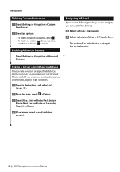
... can take a detour for a specified distance along your route or detour around . 20 GPS Navigation Instruction Manual Navigation Deleting Custom Avoidances 1 Select Settings > Navigation > Custom Avoidances. 2 Select an option: • To delete all custom avoidances, select . • To delete one custom...the avoidance, and select > Delete. This is useful if you are not following roadways as a straight line to detour around specific roads. Navigating Off Road If you encounter construction zones, closed roads, or poor road conditions. 1 Select a destination, and select Go! (page 12)....
... can take a detour for a specified distance along your route or detour around . 20 GPS Navigation Instruction Manual Navigation Deleting Custom Avoidances 1 Select Settings > Navigation > Custom Avoidances. 2 Select an option: • To delete all custom avoidances, select . • To delete one custom...the avoidance, and select > Delete. This is useful if you are not following roadways as a straight line to detour around specific roads. Navigating Off Road If you encounter construction zones, closed roads, or poor road conditions. 1 Select a destination, and select Go! (page 12)....
User Manual
Page 22
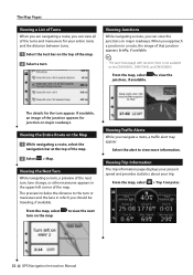
...Computer. 22 GPS Navigation Instruction Manual Viewing Trip Information The trip information page displays your present speed and provides statistics about your entire route and the distance between turns. 1 Select the text bar on the DNX690HD , DNX570HD, and DNX5080EX. to the turn . Viewing Junctions While navigating a route,...-left corner of the map. The Map Pages Viewing a List of Turns When you are navigating a route, you can view the junctions on the Map 1 While navigating a route, select the navigation bar at the top of the map. 2 Select > Map. From the map, select ...
...Computer. 22 GPS Navigation Instruction Manual Viewing Trip Information The trip information page displays your present speed and provides statistics about your entire route and the distance between turns. 1 Select the text bar on the DNX690HD , DNX570HD, and DNX5080EX. to the turn . Viewing Junctions While navigating a route,...-left corner of the map. The Map Pages Viewing a List of Turns When you are navigating a route, you can view the junctions on the Map 1 While navigating a route, select the navigation bar at the top of the map. 2 Select > Map. From the map, select ...
User Manual
Page 24
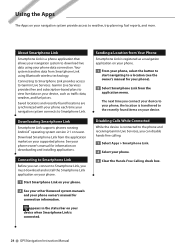
... manual for connection information. appears in the status bar on your phone. 3 Clear the Hands-Free Calling check box. 24 GPS Navigation Instruction Manual Disabling Calls While Connected While the device is connected to the phone and receiving Garmin Live Services, you can connect to..., you connect your device to your phone, the location is a phone application that allows your navigation system to download live data on your phone. 2 See your other Kenwood system manuals and your device. Downloading Smartphone Link Smartphone Link supports phones running Android™ operating ...
... manual for connection information. appears in the status bar on your phone. 3 Clear the Hands-Free Calling check box. 24 GPS Navigation Instruction Manual Disabling Calls While Connected While the device is connected to the phone and receiving Garmin Live Services, you can connect to..., you connect your device to your phone, the location is a phone application that allows your navigation system to download live data on your phone. 2 See your other Kenwood system manuals and your device. Downloading Smartphone Link Smartphone Link supports phones running Android™ operating ...
User Manual
Page 26
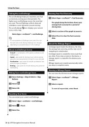
...The leaf color on the driving challenge icon changes depending on your current ecoChallenge. 1 Select Apps > ecoRoute > ecoChallenge. 2 Select > Reset. 3 Select Yes. 26 GPS Navigation Instruction Manual lose points for smooth braking; The graph along the bottom shows your driving habits. To reset all report data, select Reset. Resetting Your...fuel economy for smooth acceleration; The ecoChallenge collects data and calculates a score whenever you traveled. About ecoChallenge Scores • Overall-a combination of navigating to zoom in the challenge. If you stop a route on the map.
...The leaf color on the driving challenge icon changes depending on your current ecoChallenge. 1 Select Apps > ecoRoute > ecoChallenge. 2 Select > Reset. 3 Select Yes. 26 GPS Navigation Instruction Manual lose points for smooth braking; The graph along the bottom shows your driving habits. To reset all report data, select Reset. Resetting Your...fuel economy for smooth acceleration; The ecoChallenge collects data and calculates a score whenever you traveled. About ecoChallenge Scores • Overall-a combination of navigating to zoom in the challenge. If you stop a route on the map.
User Manual
Page 28
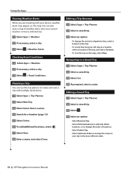
Navigating to arrange the stops on your trip in the trip, and select Duration. • To view the trip on the map. Checking Road Conditions 1 Select ..., select a city. 3 Select > Weather Alerts. Using the Apps Viewing Weather Alerts While you will stay at a location, select a location in the most-efficient order. 28 GPS Navigation Instruction Manual
Navigating to arrange the stops on your trip in the trip, and select Duration. • To view the trip on the map. Checking Road Conditions 1 Select ..., select a city. 3 Select > Weather Alerts. Using the Apps Viewing Weather Alerts While you will stay at a location, select a location in the most-efficient order. 28 GPS Navigation Instruction Manual
User Manual
Page 30
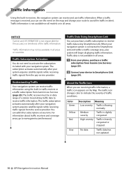
... your navigation system is received, you are receiving traffic information, a traffic icon appears on the Map. Medium severity Traffic is not responsible for the accuracy or timeliness of the traffic information. NOTICE Garmin and JVC KENWOOD is ...navigation system acquires satellite signals while receiving traffic signals from the pay service provider. Traffic data is not available on all models or in all areas. The traffic icon changes color to www.garmin.com/kenwood. You can add other subscriptions at any time. No data Traffic data has not updated. 30 GPS Navigation...
... your navigation system is received, you are receiving traffic information, a traffic icon appears on the Map. Medium severity Traffic is not responsible for the accuracy or timeliness of the traffic information. NOTICE Garmin and JVC KENWOOD is ...navigation system acquires satellite signals while receiving traffic signals from the pay service provider. Traffic data is not available on all models or in all areas. The traffic icon changes color to www.garmin.com/kenwood. You can add other subscriptions at any time. No data Traffic data has not updated. 30 GPS Navigation...
User Manual
Page 32
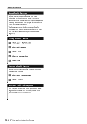
... Subscription You can purchase traffic subscriptions for more information. 32 GPS Navigation Instruction Manual Viewing a Traffic Camera Before you can view a traffic camera, you must subscribe to the photoLive service, and your device must save cameras that you want to www.garmin.com /kenwood for other regions or countries. Traffic Information About Traffic...
... Subscription You can purchase traffic subscriptions for more information. 32 GPS Navigation Instruction Manual Viewing a Traffic Camera Before you can view a traffic camera, you must subscribe to the photoLive service, and your device must save cameras that you want to www.garmin.com /kenwood for other regions or countries. Traffic Information About Traffic...
User Manual
Page 33
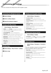
...used to use less fuel than other routes. • Off Road-calculates a direct line from receiving a GPS signal, and saves battery power. Route Preferences Select Settings > Navigation > Calculation Mode. Select the icon you to your location to avoid specific roads or areas. •...Mode-sets route preference. • Avoidances-sets road features to avoid on a route. • Custom Avoidances-allows you want to display your GPS navigation system. Adjusting the Display Settings Select Settings > Display. • Color Mode-select Day for a light background, Night for a given route...
...used to use less fuel than other routes. • Off Road-calculates a direct line from receiving a GPS signal, and saves battery power. Route Preferences Select Settings > Navigation > Calculation Mode. Select the icon you to your location to avoid specific roads or areas. •...Mode-sets route preference. • Avoidances-sets road features to avoid on a route. • Custom Avoidances-allows you want to display your GPS navigation system. Adjusting the Display Settings Select Settings > Display. • Color Mode-select Day for a light background, Night for a given route...
User Manual
Page 34
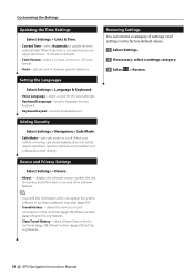
... device to record information for distances. displays the software version number, the unit ID number, and information on or off. Adding Security Select Settings > Navigation > Safe Mode. • Safe Mode-turn safe mode on several other software features. ⁄ • You need this information when you can ...Units & Time. • Current Time-select Automatic to the factory default values. 1 Select Settings. 2 If necessary, select a settings category. 3 Select > Restore. 34 GPS Navigation Instruction Manual When your keyboard. • Keyboard Layout-sets the keyboard layout.
... device to record information for distances. displays the software version number, the unit ID number, and information on or off. Adding Security Select Settings > Navigation > Safe Mode. • Safe Mode-turn safe mode on several other software features. ⁄ • You need this information when you can ...Units & Time. • Current Time-select Automatic to the factory default values. 1 Select Settings. 2 If necessary, select a settings category. 3 Select > Restore. 34 GPS Navigation Instruction Manual When your keyboard. • Keyboard Layout-sets the keyboard layout.
User Manual
Page 36
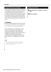
... can manually load custom points of these points. The POI Loader is lawful in the system will be overwritten. 36 GPS Navigation Instruction Manual You are not responsible for the consequences of using custom POI databases, or for ensuring that your use the Garmin POI Loader to... the POIs onto a USB mass storage device. Appendix Custom POIs (Points of Interest) You can notify you when you load custom POIs to the navigation system, any other custom POIs already saved in your POI database, use of custom POI databases. Some custom POI databases contain alert information for more...
... can manually load custom points of these points. The POI Loader is lawful in the system will be overwritten. 36 GPS Navigation Instruction Manual You are not responsible for the consequences of using custom POI databases, or for ensuring that your use the Garmin POI Loader to... the POIs onto a USB mass storage device. Appendix Custom POIs (Points of Interest) You can notify you when you load custom POIs to the navigation system, any other custom POIs already saved in your POI database, use of custom POI databases. Some custom POI databases contain alert information for more...


