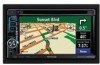
Instruction Manual
Page 2
... Routes 18 Creating a New Saved Route 18 Editing a Saved Route 18 Adding an Intermediate Destination 18 Point to Your Route Saving the Active Route 18 Navigating a Saved Route 18 Recalculating the Route 18 Deleting All Saved Routes 19 Stopping Your Route 19 Adding a Detour to a Route 19 Adding Avoidances 19...
... Routes 18 Creating a New Saved Route 18 Editing a Saved Route 18 Adding an Intermediate Destination 18 Point to Your Route Saving the Active Route 18 Navigating a Saved Route 18 Recalculating the Route 18 Deleting All Saved Routes 19 Stopping Your Route 19 Adding a Detour to a Route 19 Adding Avoidances 19...
Instruction Manual
Page 3
... the Traffic Settings 22 Adding a Traffic Receiver Subscription 22 Changing the Settings 24 Changing the General Settings 24 Changing the Map Settings 25 Changing the Navigation Settings 26 Adjusting the Traffic Settings 26 Viewing Information (About) 26 Restoring the Settings 26 Appendix 27 Using the Remote Control 27 Updating the Software...
... the Traffic Settings 22 Adding a Traffic Receiver Subscription 22 Changing the Settings 24 Changing the General Settings 24 Changing the Map Settings 25 Changing the Navigation Settings 26 Adjusting the Traffic Settings 26 Viewing Information (About) 26 Restoring the Settings 26 Appendix 27 Using the Remote Control 27 Updating the Software...
Instruction Manual
Page 4
... Precautions and Important Information Read this information carefully before starting to operate the Kenwood Car Navigation System and follow the instructions in a safe and legal manner before continuing navigation. It does not reflect road closures or road conditions, traffic congestion, weather... the following potentially hazardous situations could affect the accuracy and performance of Garmin is prohibitively expensive. 4 DNX6140/DNX6000EX/DNX5140 GPS Navigation Instruction Manual GPS satellite signals will soon be fully aware of all data sources contain inaccurate or incomplete...
... Precautions and Important Information Read this information carefully before starting to operate the Kenwood Car Navigation System and follow the instructions in a safe and legal manner before continuing navigation. It does not reflect road closures or road conditions, traffic congestion, weather... the following potentially hazardous situations could affect the accuracy and performance of Garmin is prohibitively expensive. 4 DNX6140/DNX6000EX/DNX5140 GPS Navigation Instruction Manual GPS satellite signals will soon be fully aware of all data sources contain inaccurate or incomplete...
Instruction Manual
Page 6
... for the International Sale of the United States Government, or funded in whole or in DFARS 252.2277014(a)(1) (JUN 1995) (DOD commercial computer 6 DNX6140/DNX6000EX/DNX5140 GPS Navigation Instruction Manual Disclaimer of NAVTEQ. The NAVTEQ® name and logo, the NAVTEQ and NAVTEQ ON BOARD® trademarks and logos, and other entity...
... for the International Sale of the United States Government, or funded in whole or in DFARS 252.2277014(a)(1) (JUN 1995) (DOD commercial computer 6 DNX6140/DNX6000EX/DNX5140 GPS Navigation Instruction Manual Disclaimer of NAVTEQ. The NAVTEQ® name and logo, the NAVTEQ and NAVTEQ ON BOARD® trademarks and logos, and other entity...

Instruction Manual
Page 8
... 6230. © Copyright, HER MAJESTY THE QUEEN IN RIGHT OF CANADA, as represented by DMTI Spatial or any provision of Natural Resources Canada. 8 DNX6140/DNX6000EX/DNX5140 GPS Navigation Instruction Manual This license is an authorized user and distributor of selected Statistics Canada Computer files under license from Her Majesty the Queen in...
... 6230. © Copyright, HER MAJESTY THE QUEEN IN RIGHT OF CANADA, as represented by DMTI Spatial or any provision of Natural Resources Canada. 8 DNX6140/DNX6000EX/DNX5140 GPS Navigation Instruction Manual This license is an authorized user and distributor of selected Statistics Canada Computer files under license from Her Majesty the Queen in...

Instruction Manual
Page 9
English 9 These steps normally have to be performed only once. • Select a language. • Select your current time zone. • Select whether you need to set up your system. Getting Started The first time you use your Kenwood Navigation System, you need to complete to set up the system. First Time Setup These are the steps that you want your system to auto-adjust for daylight saving time. • Select your preferred units of measure (statute or metric).
English 9 These steps normally have to be performed only once. • Select a language. • Select your current time zone. • Select whether you need to set up your system. Getting Started The first time you use your Kenwood Navigation System, you need to complete to set up the system. First Time Setup These are the steps that you want your system to auto-adjust for daylight saving time. • Select your preferred units of measure (statute or metric).

Instruction Manual
Page 10
Find It and Go! Finding a Restaurant 1 Touch Where To?. 5 Touch a place. 2 Touch Food, Hotel.... 6 Touch Go To. 3 Touch Food & Drink. 4 Touch a food category. 10 DNX6140/DNX6000EX/DNX5140 GPS Navigation Instruction Manual Follow the instructions on the next two pages to find a place and go to it!
Find It and Go! Finding a Restaurant 1 Touch Where To?. 5 Touch a place. 2 Touch Food, Hotel.... 6 Touch Go To. 3 Touch Food & Drink. 4 Touch a food category. 10 DNX6140/DNX6000EX/DNX5140 GPS Navigation Instruction Manual Follow the instructions on the next two pages to find a place and go to it!
Instruction Manual
Page 11
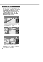
For more information about using the map. The default line color is marked with voice prompts, arrows, and directions along the top of the map. A checkered flag marks your destination. If you to your destination using the map and the other tools, see pages 16-17. Follow the arrows. Following Your Route Follow the route to your destination with a highlighted line. Your route is green. English 11 As you travel, the navigation system guides you depart from the original route, the navigation system recalculates the route and provides new route instructions.
For more information about using the map. The default line color is marked with voice prompts, arrows, and directions along the top of the map. A checkered flag marks your destination. If you to your destination using the map and the other tools, see pages 16-17. Follow the arrows. Following Your Route Follow the route to your destination with a highlighted line. Your route is green. English 11 As you travel, the navigation system guides you depart from the original route, the navigation system recalculates the route and provides new route instructions.

Instruction Manual
Page 12
... a state. Finding a Place Using the Map 1 From the Menu page, touch View Map. Touch Review. 4 Enter the street name and touch Done. 12 DNX6140/DNX6000EX/DNX5140 GPS Navigation Instruction Manual Next page 3 menu to ? > Browse Map. Touch Go To. 3 Enter the address number and touch Done. You can also touch Where to...
... a state. Finding a Place Using the Map 1 From the Menu page, touch View Map. Touch Review. 4 Enter the street name and touch Done. 12 DNX6140/DNX6000EX/DNX5140 GPS Navigation Instruction Manual Next page 3 menu to ? > Browse Map. Touch Go To. 3 Enter the address number and touch Done. You can also touch Where to...
Instruction Manual
Page 14
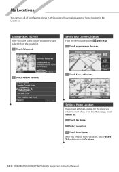
... map. 2 Touch Add As Favorite. 2 Touch Save As Favorite. You can also save your favorite places in My Locations. and then touch Go Home. 14 DNX6140/DNX6000EX/DNX5140 GPS Navigation Instruction Manual
... map. 2 Touch Add As Favorite. 2 Touch Save As Favorite. You can also save your favorite places in My Locations. and then touch Go Home. 14 DNX6140/DNX6000EX/DNX5140 GPS Navigation Instruction Manual
Instruction Manual
Page 16
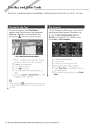
... to reset all information on the Trip Computer. 6 To reset the Maximum Speed, touch Reset Max. 16 DNX6140/DNX6000EX/DNX5140 GPS Navigation Instruction Manual The position icon shows your current location. 1 3 4 2 6 6 5 Map Page while Navigating a Route 1 While navigating a route, touch the text bar to open the map. To view the Trip Computer, select Speed...
... to reset all information on the Trip Computer. 6 To reset the Maximum Speed, touch Reset Max. 16 DNX6140/DNX6000EX/DNX5140 GPS Navigation Instruction Manual The position icon shows your current location. 1 3 4 2 6 6 5 Map Page while Navigating a Route 1 While navigating a route, touch the text bar to open the map. To view the Trip Computer, select Speed...

Instruction Manual
Page 17
... and EGNOS, visit www.garmin.com/aboutGPS/waas.html. The satellite signal-strength bars indicate the strength of each satellite you are systems of satellites and ground stations that provide GPS signal corrections, giving you are receiving. English 17 Next Turn Page • Touch and... the route. While navigating a route, touch the text bar on the map. Or, from the Menu page, touch Tools > Turn List. 1 3 2 1 Direction of this turn ...
... and EGNOS, visit www.garmin.com/aboutGPS/waas.html. The satellite signal-strength bars indicate the strength of each satellite you are systems of satellites and ground stations that provide GPS signal corrections, giving you are receiving. English 17 Next Turn Page • Touch and... the route. While navigating a route, touch the text bar on the map. Or, from the Menu page, touch Tools > Turn List. 1 3 2 1 Direction of this turn ...

Instruction Manual
Page 18
...> Routes > Save Active Route. Recalculating the Route From the Menu page, touch Tools > My Data > Routes > Recalculate Route. 18 DNX6140/DNX6000EX/DNX5140 GPS Navigation Instruction Manual Select the ending point. 4 To add a stop, touch Yes, then touch Next. For more information, see page 13. Touch...Down. Touch the route you create it. Creating and Editing Routes This section describes how to navigate. Navigating a Saved Route From the Menu page, touch Tools > My Data > Routes > Navigate Saved Route. Select the point. 5 Select your route as you want to Faster Time, ...
...> Routes > Save Active Route. Recalculating the Route From the Menu page, touch Tools > My Data > Routes > Recalculate Route. 18 DNX6140/DNX6000EX/DNX5140 GPS Navigation Instruction Manual Select the ending point. 4 To add a stop, touch Yes, then touch Next. For more information, see page 13. Touch...Down. Touch the route you create it. Creating and Editing Routes This section describes how to navigate. Navigating a Saved Route From the Menu page, touch Tools > My Data > Routes > Navigate Saved Route. Select the point. 5 Select your route as you want to Faster Time, ...

Instruction Manual
Page 19
... For example, if a road sign indicates that ramp. • Detour by Road(s) In Route-select roads on your route to avoid. The navigation system recalculates your route to avoid that the street is closed for the route. Touch to view more road types to avoid. Select the road type...enter specific areas and roads to a Route If you have entered for the next 2 miles, touch 2 miles in the list of roads. The navigation system recalculates your routes. Then touch Yes. For example, if the highway ramp is closed , select the ramp in the list. Deleting All Saved Routes ...
... For example, if a road sign indicates that ramp. • Detour by Road(s) In Route-select roads on your route to avoid. The navigation system recalculates your route to avoid that the street is closed for the route. Touch to view more road types to avoid. Select the road type...enter specific areas and roads to a Route If you have entered for the next 2 miles, touch 2 miles in the list of roads. The navigation system recalculates your routes. Then touch Yes. For example, if the highway ramp is closed , select the ramp in the list. Deleting All Saved Routes ...
Instruction Manual
Page 20
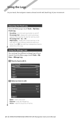
... item to edit. • Name-enter a new name. • Distance-reset the mileage log. • Active-make this log active or inactive. 20 DNX6140/DNX6000EX/DNX5140 GPS Navigation Instruction Manual To clear the track log, touch Percentage Full > Yes > OK. • Map Display-displays the current track log on and off. •...; Percentage Full-displays the current percentage capacity of the track log. Using the Logs As you travel, the navigator creates a bread-crumb trail (track log) of your travels. Touch OK.
... item to edit. • Name-enter a new name. • Distance-reset the mileage log. • Active-make this log active or inactive. 20 DNX6140/DNX6000EX/DNX5140 GPS Navigation Instruction Manual To clear the track log, touch Percentage Full > Yes > OK. • Map Display-displays the current track log on and off. •...; Percentage Full-displays the current percentage capacity of the track log. Using the Logs As you travel, the navigator creates a bread-crumb trail (track log) of your travels. Touch OK.
Instruction Manual
Page 21
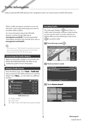
...... Traffic Events List 1 Traffic symbol 2 Color code 3 Traffic source (FM Traffic) and signal strength Next page 3 English 21 to the DNX6140/DNX6000EX/DNX5140. When a traffic message is connected to view traffic at www.garmin.com/traffic. For participating FM subscription providers and covered cities, refer... traffic module is received, you can see the event on the road you are driving. Traffic Information Using an optional FM Traffic Receiver, the navigation system can be used. When you are following a route, touch to avoid the traffic. 1 From the map, touch . 2 Touch an item...
...... Traffic Events List 1 Traffic symbol 2 Color code 3 Traffic source (FM Traffic) and signal strength Next page 3 English 21 to the DNX6140/DNX6000EX/DNX5140. When a traffic message is connected to view traffic at www.garmin.com/traffic. For participating FM subscription providers and covered cities, refer... traffic module is received, you can see the event on the road you are driving. Traffic Information Using an optional FM Traffic Receiver, the navigation system can be used. When you are following a route, touch to avoid the traffic. 1 From the map, touch . 2 Touch an item...
Instruction Manual
Page 22
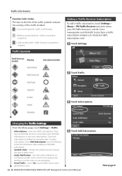
...-turn the audio notification on or off when a traffic event occurs on the road you are navigating. • Avoid Traffic-select Yes to avoid traffic events when generating a route. 4 Touch Add Subscription. 22 DNX6140/DNX6000EX/DNX5140 GPS Navigation Instruction Manual Next page 3 Go to www.garmin.com/fmtraffic to display the expiration date...
...-turn the audio notification on or off when a traffic event occurs on the road you are navigating. • Avoid Traffic-select Yes to avoid traffic events when generating a route. 4 Touch Add Subscription. 22 DNX6140/DNX6000EX/DNX5140 GPS Navigation Instruction Manual Next page 3 Go to www.garmin.com/fmtraffic to display the expiration date...
Instruction Manual
Page 24
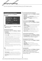
... prompts. Changing Your Time Settings From the Menu page, touch Settings > General > Time. • Time Zone-select your GPS navigation system. Change units of measure to adjust the notifications for all voice prompts and messages. Changing the Settings This section describes how to customize... voice languages are spoken. Select Speak Key Only to specify Statute or Metric for daylight saving based on ). 24 DNX6140/DNX6000EX/DNX5140 GPS Navigation Instruction Manual The Auto setting automatically adjusts the time for each time you approach turns. See page 17. Changing the...
... prompts. Changing Your Time Settings From the Menu page, touch Settings > General > Time. • Time Zone-select your GPS navigation system. Change units of measure to adjust the notifications for all voice prompts and messages. Changing the Settings This section describes how to customize... voice languages are spoken. Select Speak Key Only to specify Statute or Metric for daylight saving based on ). 24 DNX6140/DNX6000EX/DNX5140 GPS Navigation Instruction Manual The Auto setting automatically adjusts the time for each time you approach turns. See page 17. Changing the...
Instruction Manual
Page 25
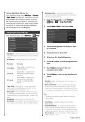
Safe Mode disables all navigation system functions that is displayed while navigating a route. Touch Wide or Thin. Display the map in 2 dimensions ... or While Routing. 3. Then touch Next. • Map Detail-adjust the amount of the map. Touch the navigation data field you can also specify a maximum Auto Zoom distance, from 120 feet to 800 miles. ⁄ ...Night for each item on the map. When it takes the map to customize which types of text for each navigation data field. 7. Normal is the default map view. • Color Mode-select Day for optimal viewing. From...
Safe Mode disables all navigation system functions that is displayed while navigating a route. Touch Wide or Thin. Display the map in 2 dimensions ... or While Routing. 3. Then touch Next. • Map Detail-adjust the amount of the map. Touch the navigation data field you can also specify a maximum Auto Zoom distance, from 120 feet to 800 miles. ⁄ ...Night for each item on the map. When it takes the map to customize which types of text for each navigation data field. 7. Normal is the default map view. • Color Mode-select Day for optimal viewing. From...
Instruction Manual
Page 26
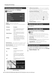
...8226; Next Turn Pop-up-select when the Next Turn page appears while navigating a route. Next Turn Page 26 DNX6140/DNX6000EX/DNX5140 GPS Navigation Instruction Manual Restoring the Settings To restore the navigation system to take more time to the Next Turn page for your destination. Preference... Settings See page 22. Creates a direct-line route from your current location to your preference each turn . This feature allows the navigation system to continually search for a better route to your vehicle type. • Preference-select a preference for every turn . • Off...
...8226; Next Turn Pop-up-select when the Next Turn page appears while navigating a route. Next Turn Page 26 DNX6140/DNX6000EX/DNX5140 GPS Navigation Instruction Manual Restoring the Settings To restore the navigation system to take more time to the Next Turn page for your destination. Preference... Settings See page 22. Creates a direct-line route from your current location to your preference each turn . This feature allows the navigation system to continually search for a better route to your vehicle type. • Preference-select a preference for every turn . • Off...


