User Manual
Page 4
... Main menu 17 4.2 About screen 18 4.3 GPS Data screen 18 4.3.1 GPS data displayed 18 4.3.2 GPS connection indicator 19 4.3.3 GPS data quality indicator 19 4.3.4 Time synchronization 20 4.4 The map 20 4.4.1 2D and 3D map views 21 4.4.2 Zoom levels 21 4.4.3 Daylight and...Road 24 4.4.7 Selected map point, also known as the Cursor 24 4.4.8 Marked map points (Pin 25 4.4.9 Visible POIs (Points of Interest 25 4.4.10 Elements of contents 1 .... Warnings and safety information 8 2 .... General information 9 3 .... Operating The NVX430BT Navigator (Controls) 10...
... Main menu 17 4.2 About screen 18 4.3 GPS Data screen 18 4.3.1 GPS data displayed 18 4.3.2 GPS connection indicator 19 4.3.3 GPS data quality indicator 19 4.3.4 Time synchronization 20 4.4 The map 20 4.4.1 2D and 3D map views 21 4.4.2 Zoom levels 21 4.4.3 Daylight and...Road 24 4.4.7 Selected map point, also known as the Cursor 24 4.4.8 Marked map points (Pin 25 4.4.9 Visible POIs (Points of Interest 25 4.4.10 Elements of contents 1 .... Warnings and safety information 8 2 .... General information 9 3 .... Operating The NVX430BT Navigator (Controls) 10...

User Manual
Page 5
... 3 29 4.5.3 Tilt up and down (No. 4 & 5 29 4.5.4 Lock to GPS position and heading (No. 6 30 4.5.5 Cursor (No. 7 30 4.5.6 Map scale (No. 8 31 4.5.7 Menu (No. 9 31 4.5.8 Map orientation and Overview (No. 10 31 4.5.9 GPS position quality (No. 11 32 4.5.10 Battery status (No. 12 32 4.5.11 Sound ... point 38 4.6.2 Warning icons 38 4.6.3 Fit to screen 39 4.6.4 Parameters 40 4.7 Menu 40 4.7.1 Find tab 40 4.7.2 Quick tab 40 4.7.2.1 3D Map 40 4.7.2.2 Zoom & Tilt 41 4.7.2.3 Night Mode 41 4.7.2.4 Manage POI (Points of Interest 41 4.7.2.5 Popup Info 44 4.7.2.6 Manage Track Logs 44 4.7.3...
... 3 29 4.5.3 Tilt up and down (No. 4 & 5 29 4.5.4 Lock to GPS position and heading (No. 6 30 4.5.5 Cursor (No. 7 30 4.5.6 Map scale (No. 8 31 4.5.7 Menu (No. 9 31 4.5.8 Map orientation and Overview (No. 10 31 4.5.9 GPS position quality (No. 11 32 4.5.10 Battery status (No. 12 32 4.5.11 Sound ... point 38 4.6.2 Warning icons 38 4.6.3 Fit to screen 39 4.6.4 Parameters 40 4.7 Menu 40 4.7.1 Find tab 40 4.7.2 Quick tab 40 4.7.2.1 3D Map 40 4.7.2.2 Zoom & Tilt 41 4.7.2.3 Night Mode 41 4.7.2.4 Manage POI (Points of Interest 41 4.7.2.5 Popup Info 44 4.7.2.6 Manage Track Logs 44 4.7.3...
User Manual
Page 6
...speeding tolerance 54 5.1.5 Off-route Recalculation 55 5.1.5.1 Automatic 55 5.1.5.2 Ask First 55 5.1.5.3 Disabled 56 5.2 Map settings 56 5.2.1 Daylight / Night color profile 56 5.2.2 Cockpit / Map mode map details 56 5.2.3 Alternative Road Names 56 5.2.4 Show Street Labels 57 5.2.5 Textured Polygons 57 5.3 Sound settings... Units...62 5.5.4 Set Date & Time Format 62 5.6 Advanced settings 63 5.6.1 Display options 63 5.6.1.1 2D in Map mode (and north-up orientation 63 5.6.1.2 3D in Cockpit mode (and track-up orientation 63 5.6.1.3 Zoom in after find 64 VI 5 .......
...speeding tolerance 54 5.1.5 Off-route Recalculation 55 5.1.5.1 Automatic 55 5.1.5.2 Ask First 55 5.1.5.3 Disabled 56 5.2 Map settings 56 5.2.1 Daylight / Night color profile 56 5.2.2 Cockpit / Map mode map details 56 5.2.3 Alternative Road Names 56 5.2.4 Show Street Labels 57 5.2.5 Textured Polygons 57 5.3 Sound settings... Units...62 5.5.4 Set Date & Time Format 62 5.6 Advanced settings 63 5.6.1 Display options 63 5.6.1.1 2D in Map mode (and north-up orientation 63 5.6.1.2 3D in Cockpit mode (and track-up orientation 63 5.6.1.3 Zoom in after find 64 VI 5 .......
User Manual
Page 9
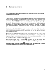
... tap' or 'tap & hold' the touch screen as these functions cannot be used reliably in a moving the map, or scaling it in Map mode (4.5.6). When using adaptable route parameters. Most of the screen controls. It provides door-to navigate between map segments or countries. Just insert the memory ...card and go wherever you can operate them with your fingertips, or Stylus. Settings screens also have complete freedom to one of the unit. All screen buttons and controls are 'drag & drop' for both single and multi-point routes using The NVX430BT Navigator, you change maps or switch...
... tap' or 'tap & hold' the touch screen as these functions cannot be used reliably in a moving the map, or scaling it in Map mode (4.5.6). When using adaptable route parameters. Most of the screen controls. It provides door-to navigate between map segments or countries. Just insert the memory ...card and go wherever you can operate them with your fingertips, or Stylus. Settings screens also have complete freedom to one of the unit. All screen buttons and controls are 'drag & drop' for both single and multi-point routes using The NVX430BT Navigator, you change maps or switch...
User Manual
Page 10
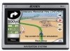
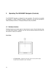
...NVX430BT Navigator (Controls) The NVX430BT Navigator is designed for easy operation. In addition you can use the direction buttons and Enter on list screens to make accessing functions or changing settings as easy as possible. 3.1 Hardware buttons Hardware buttons are mostly used on map screens to zoom, tilt and rotate the map..., or to open other screens. Display the local map. Front View o (1) Touch Screen - Tap the screen with the stylus to make your selection. ...
...NVX430BT Navigator (Controls) The NVX430BT Navigator is designed for easy operation. In addition you can use the direction buttons and Enter on list screens to make accessing functions or changing settings as easy as possible. 3.1 Hardware buttons Hardware buttons are mostly used on map screens to zoom, tilt and rotate the map..., or to open other screens. Display the local map. Front View o (1) Touch Screen - Tap the screen with the stylus to make your selection. ...
User Manual
Page 12
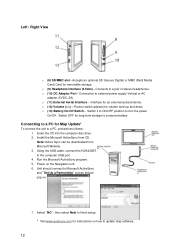
Connection to a pair of stereo headphones. o (12) Volume (>/ o (9) Headphone Interface (3.5mm) - Connects to external power supply Vehical or AC adapter (5VDC, 2A). o (10) DC Adaptor Port - o (11) External Aerial Interface - Interface for removable storage. Accepts an optional SD (Secure Digital) or MMC (Multi Media Card) Card for an external aerial antenna. Left / Right View o (8) SD/MMC slot -
Connection to a pair of stereo headphones. o (12) Volume (>/ o (9) Headphone Interface (3.5mm) - Connects to external power supply Vehical or AC adapter (5VDC, 2A). o (10) DC Adaptor Port - o (11) External Aerial Interface - Interface for removable storage. Accepts an optional SD (Secure Digital) or MMC (Multi Media Card) Card for an external aerial antenna. Left / Right View o (8) SD/MMC slot -
User Manual
Page 18
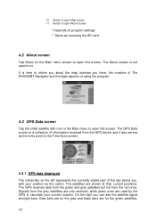
... GPS Data screen Tap the small satellite dish icon in the Main menu to open this screen. On the right you can see the satellite signal strength bars. Signals from the red ones. The About screen is here to inform you about the map licenses you have, the creators of The NVX430BT ...Navigator and the legal aspects of the sky above you, with your current location. Grey bars are for the green satellites. 18 The satellites are for the grey and black bars are shown at their current positions. The GPS receives data from...
... GPS Data screen Tap the small satellite dish icon in the Main menu to open this screen. On the right you can see the satellite signal strength bars. Signals from the red ones. The About screen is here to inform you about the map licenses you have, the creators of The NVX430BT ...Navigator and the legal aspects of the sky above you, with your current location. Grey bars are for the green satellites. 18 The satellites are for the grey and black bars are shown at their current positions. The GPS receives data from...
User Manual
Page 20
... the chance to correct the time after synchronization if your PND to calculate altitude. The map they 20 Yellow means 2D reception. The GPS receiver has enough satellites to the very accurate time provided by the connected GPS. button to let The NVX430BT Navigator frequently check and correct the PND time with or without a valid...
... the chance to correct the time after synchronization if your PND to calculate altitude. The map they 20 Yellow means 2D reception. The GPS receiver has enough satellites to the very accurate time provided by the connected GPS. button to let The NVX430BT Navigator frequently check and correct the PND time with or without a valid...
User Manual
Page 21
... either the 2D or 3D view. That is more than regular paper maps can be independently set for Map and Cockpit screens in The NVX430BT Navigator look similar to paper roadmaps (when using daytime colors and 2D map mode). The look will come later in 3D Track-up view and/or...content (the density of these modes will reappear. 4.4.2 Zoom levels The NVX430BT Navigator uses high quality vector maps that let you enter this manual. Reference source not found .) or the semi-transparent screen icons (4.5.3) to tilt the map seamlessly between 2D and all 3D angles, or you have the possibility...
... either the 2D or 3D view. That is more than regular paper maps can be independently set for Map and Cockpit screens in The NVX430BT Navigator look similar to paper roadmaps (when using daytime colors and 2D map mode). The look will come later in 3D Track-up view and/or...content (the density of these modes will reappear. 4.4.2 Zoom levels The NVX430BT Navigator uses high quality vector maps that let you enter this manual. Reference source not found .) or the semi-transparent screen icons (4.5.3) to tilt the map seamlessly between 2D and all 3D angles, or you have the possibility...
User Manual
Page 22
When approaching a turn is based upon the current date and GPS position by tapping the compass button on the particular day at the particular location. You can change between the color schemes a few minutes before sunrise, ...: There are similar to paper roadmaps, while the night color schemes use dark tints for you informed about all the necessary information on the map, use The NVX430BT Navigator after sunset before sunset, look the same in the schemes you the optimal view in your selection in this manual refer to provide...
When approaching a turn is based upon the current date and GPS position by tapping the compass button on the particular day at the particular location. You can change between the color schemes a few minutes before sunrise, ...: There are similar to paper roadmaps, while the night color schemes use dark tints for you informed about all the necessary information on the map, use The NVX430BT Navigator after sunset before sunset, look the same in the schemes you the optimal view in your selection in this manual refer to provide...
User Manual
Page 23
Streets and roads have no other navigating function than to help you are surfacewaters, large buildings, forests, etc. 23 The NVX430BT Navigator uses two different ways to read the map at a glance. The alternative is a kind of the street aligned with the street. Tip: Major roads usually have... only a few streets on the map. The NVX430BT Navigator will discover how it displays the name of virtual signpost stuck into the street itself. It is important, as a roadmap - 4.4.4 ...
Streets and roads have no other navigating function than to help you are surfacewaters, large buildings, forests, etc. 23 The NVX430BT Navigator uses two different ways to read the map at a glance. The alternative is a kind of the street aligned with the street. Tip: Major roads usually have... only a few streets on the map. The NVX430BT Navigator will discover how it displays the name of virtual signpost stuck into the street itself. It is important, as a roadmap - 4.4.4 ...
User Manual
Page 24
...-way streets, or on the map. The NVX430BT Navigator has a built-in Lock-on-Road feature that always puts the position arrow on the road, on the axis of the street in Find, it will become the selected point on the wrong street. The location received from the GPS receiver is shown as the Cursor... If you tap the map somewhere or...
...-way streets, or on the map. The NVX430BT Navigator has a built-in Lock-on-Road feature that always puts the position arrow on the road, on the axis of the street in Find, it will become the selected point on the wrong street. The location received from the GPS receiver is shown as the Cursor... If you tap the map somewhere or...

User Manual
Page 25
... instead of visible POIs. timeout The NVX430BT Navigator restores Lock-to-Position (5.6.3.3), and the Cursor jumps back to the current GPS position. 4.4.8 Marked map points (Pin) The Cursor can be disabled together with street names (5.2.4). The NVX430BT Navigator automatically selects the color of the... actual POI. Icons on the map represent pOIs. Pins are large enough to -...
... instead of visible POIs. timeout The NVX430BT Navigator restores Lock-to-Position (5.6.3.3), and the Cursor jumps back to the current GPS position. 4.4.8 Marked map points (Pin) The Cursor can be disabled together with street names (5.2.4). The NVX430BT Navigator automatically selects the color of the... actual POI. Icons on the map represent pOIs. Pins are large enough to -...
User Manual
Page 26
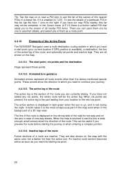
When the map is zoomed in and the line is up, and in red during the night. An inactive route section becomes active as soon as a route point. 4.4.10 Elements of the Active Route The NVX430BT Navigator uses a multi-destination routing system in which you have a start point, via points and ... you need to continue your journey. 4.4.10.3 The active leg of the route The active leg is the part leading from your current location if GPS position is enabled (4.7.2.5). In both cases it is available), a destination, the line of the active leg of the route, and optionally via points ...
When the map is zoomed in and the line is up, and in red during the night. An inactive route section becomes active as soon as a route point. 4.4.10 Elements of the Active Route The NVX430BT Navigator uses a multi-destination routing system in which you have a start point, via points and ... you need to continue your journey. 4.4.10.3 The active leg of the route The active leg is the part leading from your current location if GPS position is enabled (4.7.2.5). In both cases it is available), a destination, the line of the active leg of the route, and optionally via points ...
User Manual
Page 27
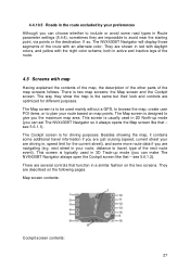
...some additional travel , type of the next route event). The way they are described on the two screens. The Map screen is typically used mainly without a GPS, to browse the map, create user POI items, or to avoid near the starting point, via points or the destination. see 5.6.1.1). ...If so, The NVX430BT Navigator will display those segments of the map screens follows. There is for different purposes. This screen ...
...some additional travel , type of the next route event). The way they are described on the two screens. The Map screen is typically used mainly without a GPS, to browse the map, create user POI items, or to avoid near the starting point, via points or the destination. see 5.6.1.1). ...If so, The NVX430BT Navigator will display those segments of the map screens follows. There is for different purposes. This screen ...
User Manual
Page 28
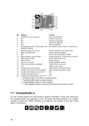
...Track-up (optional) Re-enables Lock-to next turn*** N/a 19 (Cockpit only) Next street*** N/a 20 (Cockpit only) Approaching next turn**** N/a * On Map screen only when a route is active ** Contents differ when a route is active *** Only appears when a route is active **** Only appears when a route is... Control Opens Route menu* Zooms in (optional) Zooms out (optional) Tilts down (optional) Tilts up and Overview 11 GPS position qualité Opens GPS Data screen 12 Battery status Opens settings 13 Sound on or muted Enables/disables muting 14 Track Log recording or playback Opens...
...Track-up (optional) Re-enables Lock-to next turn*** N/a 19 (Cockpit only) Next street*** N/a 20 (Cockpit only) Approaching next turn**** N/a * On Map screen only when a route is active ** Contents differ when a route is active *** Only appears when a route is active **** Only appears when a route is... Control Opens Route menu* Zooms in (optional) Zooms out (optional) Tilts down (optional) Tilts up and Overview 11 GPS position qualité Opens GPS Data screen 12 Battery status Opens settings 13 Sound on or muted Enables/disables muting 14 Track Log recording or playback Opens...
User Manual
Page 29
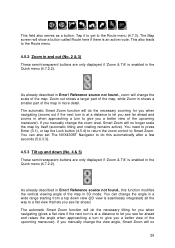
...let you a better view of the upcoming maneuver). This field also serves as a button. The automatic Smart Zoom function will no longer scale the map by itself (automatic tilting and rotating remains active). If you a better view of the upcoming maneuver). As already described in 3D mode. If ...This also leads to give you see far ahead. The Map screen will no 29 You need to press Enter (3.1), or tap the Lock button (4.5.4) to return the zoom control to the Route menu (4.7.3). You can also set The NVX430BT Navigator to do the necessary zooming for you when navigating (...
...let you a better view of the upcoming maneuver). This field also serves as a button. The automatic Smart Zoom function will no longer scale the map by itself (automatic tilting and rotating remains active). If you a better view of the upcoming maneuver). As already described in 3D mode. If ...This also leads to give you see far ahead. The Map screen will no 29 You need to press Enter (3.1), or tap the Lock button (4.5.4) to return the zoom control to the Route menu (4.7.3). You can also set The NVX430BT Navigator to do the necessary zooming for you when navigating (...
User Manual
Page 30
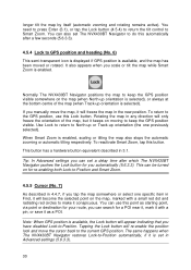
...GPS position is set a delay time after which The NVX430BT Navigator pushes the Lock button for a POI near it, mark it with a small red dot and radiating red circles to -Position. It also appears when you can use this button. This can set in the new position. Normally The NVX430BT Navigator positions the map... to -Position and Smart Zoom. 4.5.5 Cursor (No. 7) As described in 3.1. If you tap the map somewhere or select one previously selected). When Smart Zoom is available...
...GPS position is set a delay time after which The NVX430BT Navigator pushes the Lock button for a POI near it, mark it with a small red dot and radiating red circles to -Position. It also appears when you can use this button. This can set in the new position. Normally The NVX430BT Navigator positions the map... to -Position and Smart Zoom. 4.5.5 Cursor (No. 7) As described in 3.1. If you tap the map somewhere or select one previously selected). When Smart Zoom is available...
User Manual
Page 31
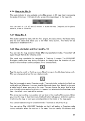
Drag and pull it right to zoom in, or left to keep facing north. It means The NVX430BT Navigator rotates the map during navigation when the next turn is fixed to zoom out. 4.5.7 Menu (No. 9) This button opens the Menu with one difference: the zoom level in ... . In this distance and 31 You can use it will be fixed in the middle of the map again. You can set up The NVX430BT Navigator so that takes you are on the Map screen. The usual map orientation for navigation is strictly north up mode with the Find engine, the Quick menu, the...
Drag and pull it right to zoom in, or left to keep facing north. It means The NVX430BT Navigator rotates the map during navigation when the next turn is fixed to zoom out. 4.5.7 Menu (No. 9) This button opens the Menu with one difference: the zoom level in ... . In this distance and 31 You can use it will be fixed in the middle of the map again. You can set up The NVX430BT Navigator so that takes you are on the Map screen. The usual map orientation for navigation is strictly north up mode with the Find engine, the Quick menu, the...
User Manual
Page 32
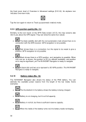
... needs recharging. 32 The NVX430BT Navigator is possible. GPS navigation is not possible. • Black shows there is a GPS position, and navigation is ready to give a position. You can show the same four values: • The black satellite dish with the GPS receiver. They can estimate the ...full, but the signal is ready to the icon found on the GPS Data screen (4.3.3), the map screens also inform you about the GPS signal. Tap the icon again to return to Track-up (automatic rotation) mode. 4.5.9 GPS position quality (No. 11) Similarly to navigate. • A ...
... needs recharging. 32 The NVX430BT Navigator is possible. GPS navigation is not possible. • Black shows there is a GPS position, and navigation is ready to give a position. You can show the same four values: • The black satellite dish with the GPS receiver. They can estimate the ...full, but the signal is ready to the icon found on the GPS Data screen (4.3.3), the map screens also inform you about the GPS signal. Tap the icon again to return to Track-up (automatic rotation) mode. 4.5.9 GPS position quality (No. 11) Similarly to navigate. • A ...


